Brief to council re: rezoning of Broadway
- AM1519-: PAM 1972-200
- Item
- 1972
16 results with digital objects Show results with digital objects
Brief to council re: rezoning of Broadway
Part of City of Vancouver Archives technical and cartographic drawing collection
Item is a map showing zoning in Burnaby according to the following zoning districts: commercial, light industrial, heavy industrial, residential and unzoned. The map also shows streets, railways and municipal boundaries.
Burnaby (B.C.). Town Planning Commission

City of North Vancouver zone map showing "use" and "set-back" restrictions
Part of City of Vancouver Archives technical and cartographic drawing collection
Item is a map showing zoning in the city of North Vancouver. Zones include residential (single-family residences only, semi-detached residences and apartment blocks, hotels, etc.) business (Local shopping and business and buildings of the warehouse class) and industrial districts.
City of Vancouver : generalized future land use in relation to feasibility network
Part of City of Vancouver fonds
Item is a copy of an Engineering Department map which has been annotated to show pre-1916 residential construction, existing major streets, public and semi-public buildings, single and two-family dwellings, multiple family dwellings, district commercial, industrial, open spaces, proposed additional major streets - 1976, proposed deletion of existing major streets - 1976, proposed freeways and secondary schools in the city of Vancouver.
Vancouver (B.C.). Planning Department
City of Vancouver public hearing, rezoning application

City of Vancouver, British Columbia : zoning diagram
Part of City of Vancouver Archives technical and cartographic drawing collection
Part contains a zoning map showing city streets, residential, apartment, commercial and industrial districts, as well as parkways and open spaces. Concentric circles spaced a mile apart on the map emanate from a point in downtown Vancouver.
Composite industrial map of the metropolitan area, Lower Mainland, British Columbia
Part of City of Vancouver Archives technical and cartographic drawing collection
Item is a map showing areas either occupied by industry or zoned for industry in the following municipalities of the Lower Mainland: Vancouver, New Westminster, North Vancouver, Port Coquitlam, Port Moody, Burnaby, Coquitlam, Delta, North Vancouver, Richmond, Surrey and West Vancouver. Industrial areas are categorized as either light or heavy industry. New housing developments, main traffic arteries, railways and municipal boundaries are also indicated.
CP Rail : False Creek lands rezoning application
"We are pleased to submit this document in support of an application to rezone the CP Rail False Creek lands between the Cambie and Granville Street bridges. . . ."
Canadian Pacific Railway Company

Development in the western portion of the Lower Mainland region, 1968
Part of City of Vancouver Archives technical and cartographic drawing collection
Item is a map showing residential, commercial, industrial, civic and institutional, parks and recreational and agricultural zoning in the Lower Mainland area, including West Vancouver, North Vancouver, Vancouver, Burnaby, Coquitlam, New Westminster, Richmond, Maple Ridge, Langley, Surrey, Delta and White Rock. Information has been added to a base map published by the Province of British Columbia.
Part of City of Vancouver Archives technical and cartographic drawing collection
Map shows major highways and zoning in the Greater Vancouver area according to the following: residential, commerical, industrial, civic and institutional, parks and recreational and agricultural.
Existing service stations, retail shopping centres and commercial zoning
Part of City of Vancouver Archives technical and cartographic drawing collection
Item is a map showing the locations of retail shopping centres in Vancouver according to local, district and regional function. Map also shows locations of service stations and commercially zoned areas.
Vancouver (B.C.). Planning Department

Existing service stations, retail shopping centres and commercial zoning
Part of City of Vancouver fonds
Item is a map showing retail shopping centres, zoning, and service station distribution in Vancouver.
Survey presented to the North West Point Grey home Owners' Association. June 1963
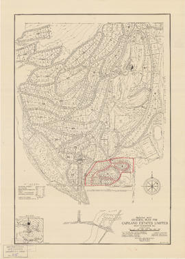
General plan for Capilano Estates Limited
Part of City of Vancouver Archives technical and cartographic drawing collection
Item is a map showing the layout of the proposed Capilano Estates development, including a golf course, a polo field, riding stables, housing lots, and park land. Annotations are pencil outlines of blocks in the southern end of the development.
Generalized land use : Greater Vancouver Regional District
Part of City of Vancouver Archives technical and cartographic drawing collection
Item is a map showing the general patterns of development in the member municipalities and electoral areas of the Greater Vancouver Regional District as of June 1979. Land use has been categorized according to the following categories : rural residential; single family residential; medium density residential; high density residential; commercial; industrial; extractive; transportation, communications and utilities; institutional; recreational areas and parks; farm; and open and undeveloped areas.
Industrial zoning : changes from 1930-1962
Part of City of Vancouver fonds
Map is Plan no. 4105A Sheet 10 of 11 of the City of Vancouver, showing streets, blocks, hospitals, golf courses, First Nations reserves, parks, schools, city yards and cemetery. Map is hand coloured to show light and heavy industry additions, light and heavy industry deletions, and changes from light to heavy industry and heavy to light industry. Base map is titled "City of Vancouver zoning map : a diagrammatic reproduction of schedule "D" : zoning district plan and schedule "E" : building lines of zoning and development by-law no. 3575 (amended to by-law no. 3972, March 1962)." Map is dated June 25, 1962 and labelled "1962 June 4105 A-10, Industrial Study 1964."

Key map showing proposed areas for partial and comprehensive redevelopment
Part of City of Vancouver fonds
Item is a map showing the boundaries of the redevelopment study area, comprehensive redevelopment areas, limited redevelopment areas and the East End study area. The boundary of the study area lies roughly between Burrard Inlet in the north and 33rd Avenue in the south and between Nanaimo Street in the east and Carnarvon Street in the west.

Map of City of Vancouver, British Columbia
Part of City of Vancouver Archives technical and cartographic drawing collection
Part contains a zoning map showing city streets, residential, apartment, commercial and industrial districts, as well as City-owned parks and golf courses. Concentric circles spaced a mile apart on the map emanate from a point in downtown Vancouver.

Part of City publications collection
Item is a map showing proposed commercial and residential zones and the location of an elementary school in the area directly south of Simon Fraser University. Base map shows land use for the area bounded by Willingdon Avenue, North Road, Barnet Road, and the Trans-Canada Highway.

Official Regional Plan : proposed amendments within the City of Vancouver
Part of City publications collection
Item is a map showing proposed amendments to industrial and rural zoning areas.

Point Grey, B.C. : district map
Part of City of Vancouver Archives technical and cartographic drawing collection
Item is a flyer or promotional brochure showing proposed zoning districts for the municipality of Point Grey to be created by a proposed zoning by-law. The districts are depicted on the map which makes up the majority of the item. Surrounding the map is the text of the proposed by-law.

Proposed development of Vancouver City Yard, 49th Avenue at Ross Street, South Vancouver
Part of City of Vancouver fonds
Item is a site plan showing existing and proposed storage, accommodation, and work buildings, landscaping, and proposed re-zoning.

Part of City of Vancouver fonds
Item is a map showing proposed commercial and industrial zoning at high and medium densities, and the boundaries of the proposed high density core and parking areas in downtown from Burrard Street, Robson Street, and Nicola Street in the west to Main Street in the east.

Proposed zoning : comprehensive redevelopment areas
Part of City of Vancouver fonds
Item is a map showing proposed zoning for two comprehensive redevelopment areas according to the following district types: residential, commercial (suburban), commercial (medium density), industrial (light) and industrial (heavy). Map also shows the boundaries of the comprehensive redevelopment areas. These two areas lie roughly between Burrard Inlet in the north and 10th Avenue in the south and between Semlin Drive in the east and Burrard Street in the west.

Redevelopment plan for Jericho Department of National Defence lands
Part of City of Vancouver Archives technical and cartographic drawing collection
Item is a map showing proposed redevelopment of portions of former Department of National Defence lands in the Jericho area. The map shows existing city parks, D.N.D. lands to be taken over for parks and recreation, city owned land, single family land, town houses, garden apartments and town houses and proposed new roads. The map appears to have been removed from a report.
Vancouver (B.C.). Engineering Services

Rezoning application map (Point Grey Road)
Part of City of Vancouver Archives technical and cartographic drawing collection
Item is a map that would have been created to accompany an application for re-zoning for Block 235 D.L. 538 and water lots 5834, 5601 and 5600. It appears that this application failed, as no amendment to By-law 3575 for these properties has been found.
Vancouver (B.C.). Planning Department
Part of City of Vancouver fonds
File consists of three identical base maps of the area from Earles Street to Boundary Road and 29th Avenue to 49th Avenue, which have been annotated to show the sewage system, water services system, and types of occupancy in the area bounded by Joyce Street, Boundary Road, Wellington Avenue and Kingsway.
The effects of rezoning on property values in the city of Vancouver

Vancouver South, British Columbia
Part of City of Vancouver Archives technical and cartographic drawing collection
Item is a map showing land use status of the area from Vancouver South in the north through Tsawwassen in the south and from Boundary Road in the east to Georgia Strait in the west. Ancillary map on recto shows index map of adjoining maps in the series (including New Westminster, Sumas, Chilliwack and Galiano Island).
Vancouver, B.C. zoning diagram
Part of City of Vancouver Archives technical and cartographic drawing collection
Item is a pamphlet on zoning in Vancouver. The front side of the pamphlet contains text regarding zoning and the planning process. The back side of the sheet contains a zoning map.
Vancouver, British Columbia : [urban analysis maps]
Part of City of Vancouver Archives technical and cartographic drawing collection
Maps show land use, land slope and elevation, density of buildings, structural material of buildings, height of buildings, water supply systems, sewage systems, electric power systems, gas trunk systems, population distribution, daytime population distribution, dwelling units, schools, hospitals and doctors, land transportation, port facilities, food manufacturing, textile manufacturing, wood product manufacturing, metal product manufacturing, transportation equipment manufacturing, non-metallic mineral and chemical products manufacturing, retail and wholesale food enterprises, retail and wholesale building materials enterprises, retail and wholesale drugs, general merchandise, apparel and accessories enterprises, retail and wholesale clothing and shoes enterprises, retail and wholesale furnishing enterprises and hotels and eating places in the Greater Vancouver area (including West Vancouver, North Vancouver, Vancouver, Burnaby, New Westminster, the northern portion of Richmond and the western portion of Coquitlam). Much of the data for these maps was derived from the 1961 census of Canada.
Will this be your backyard? Will this be your street?