- COV-PG-S247-: LEG1153.356
- Item
- [1923?]
Part of City of Vancouver fonds
Part of City of Vancouver fonds

Part of City of Vancouver fonds

Part of City of Vancouver fonds

Part of City of Vancouver fonds

Part of City of Vancouver fonds

Part of City of Vancouver fonds
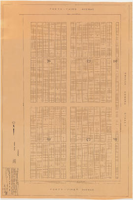
![General plan - sheet 11 [Arbutus Street to Celtic Avenue to Fraser River]](/uploads/r/null/3/f/d/3fd9a37e7d563f1ab5ea2d9d72418a55895d86310b0a78eab48407b8b835b701/136e3b9b-509e-4f21-94e7-d53135afd227-LEG1153_142.jpg)
General plan - sheet 11 [Arbutus Street to Celtic Avenue to Fraser River]
Part of City of Vancouver fonds
![General plan - sheet 12 [Cambie Street to Sixteenth Avenue to Arbutus Street to Twenty-third Avenue]](/uploads/r/null/8/5/f/85f228499ffefb33a4420336b35885201d899673637daca6b1eebd8fd0111f3e/4ee908fd-0dfa-4297-8198-99592dee3c2b-LEG1153_142.jpg)
General plan - sheet 12 [Cambie Street to Sixteenth Avenue to Arbutus Street to Twenty-third Avenue]
Part of City of Vancouver fonds

Part of City of Vancouver fonds

Part of City of Vancouver fonds

Part of City of Vancouver fonds

Part of City of Vancouver fonds

Part of City of Vancouver fonds
![General plan - sheet 18 [Cambie Street to Dogwood Avenue to Arbutus Street to Sixtieth Avenue]](/uploads/r/null/7/3/0/730edd4b5bb09f437c0bf207248dd5623603f3054a8b42c57e71efc48dbc508f/3aa6b0df-f6ac-4001-92db-28b342873388-LEG1153_142.jpg)
General plan - sheet 18 [Cambie Street to Dogwood Avenue to Arbutus Street to Sixtieth Avenue]
Part of City of Vancouver fonds
![General plan - sheet 19 [Ash Street to Fifty-ninth Avenue to Arbutus Street to Sixty-seventh Avenue]](/uploads/r/null/c/d/9/cd91342eba2fda61236d03f55e1772cfcacc898fda7f2de3b55408ad37e4f618/ab184e33-c017-49fd-8425-47302485efcc-LEG1153_142.jpg)
General plan - sheet 19 [Ash Street to Fifty-ninth Avenue to Arbutus Street to Sixty-seventh Avenue]
Part of City of Vancouver fonds
Part of City of Vancouver fonds
![General plan - sheet 21 [Heather Street to Seventy-third Avenue to Fraser River]](/uploads/r/null/d/1/6/d1697104a1a4279099944caca836ec97365dd22d65bd611490ee71828ae0ce96/5bf4af24-c2fe-477e-a13d-1ba1c9107389-LEG1153_142.jpg)
General plan - sheet 21 [Heather Street to Seventy-third Avenue to Fraser River]
Part of City of Vancouver fonds

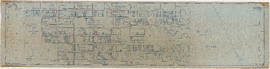
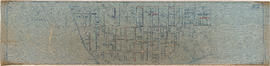
Sewerage system : plan of Point Grey Municipality
Part of City of Vancouver fonds
Item is a map annotated to show the sewer system in Point Grey. Base map was created by the Vancouver Map and Blue Print Co. and shows streets, railways, and district lot and block numbers.

Key plan showing Mountain View Cemetery, Vancouver, B.C.
Part of City of Vancouver fonds
Item is a map of Mountain View Cemetery, showing blocks and plots.

Key plan showing Mountain View Cemetery, Vancouver, B.C.
Part of City of Vancouver fonds
Item is a map of Mountain View Cemetery, showing blocks and plots. Annotations are noted regarding pathways and notes re: Jewish section of the cemetery.
Portion of area bounded by 41st Avenue, Prince Edward Street & 43rd Avenue
Part of City of Vancouver fonds
Item is a map of a portion of Mountain View Cemetery showing existing graves before proposed addition.
Portion of area bounded by 41st Avenue, Prince Edward Street & 43rd Avenue
Part of City of Vancouver fonds
Item is a map of a portion of Mountain View Cemetery showing existing graves, as well as locations of proposed additional graves.
![[Aerial survey photograph]](/uploads/r/null/f/a/fab195a7fc233deb2d6de7cd7adbb1c17e581561907ad4326ec3e70802b8053e/7186442f-d249-4e5f-9aca-ac698f0376fd-A40953_142.jpg)
Part of City of Vancouver fonds
![[Aerial survey photograph with body of water]](/uploads/r/null/0/8/08c3cd4f3f862932c7f8892684151a7b8147e1d257a9a70930541c72b57f2f9b/348a6a46-4362-459e-ac8b-e210bffcfe4f-A40990_142.jpg)
[Aerial survey photograph with body of water]
Part of City of Vancouver fonds
![[Aerial survey photograph]](/uploads/r/null/8/6/86329ac6a4aa2d72519aa3411a56ef7fc696546a8bd1c916228309a90e76067a/889ed9ec-97c7-4317-9c11-53a8c123430d-A40954_142.jpg)
Part of City of Vancouver fonds
![[Aerial survey photograph]](/uploads/r/null/5/d/5d61d720b2a88dce52e09ab49a7ef4942b0eac1405c7b4e765e3beda6f25999a/b0d55cc5-84f3-47e9-919c-a036db614315-A48057_142.jpg)
Part of City of Vancouver fonds
![[Aerial survey photograph with river]](/uploads/r/null/f/e/fe98d2abefe97f551eec30eb0326bbb273e1ee059396e9f6909ffc1984a9f7ea/6786642e-fcc8-4f00-bf6d-26d122fae5ec-A38258_142.jpg)
[Aerial survey photograph with river]
Part of City of Vancouver fonds
Part of City of Vancouver fonds
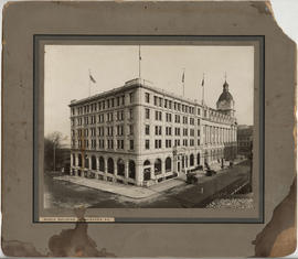
Photograph shows the Winch building on the corner of Howe Street and West Hastings. The Post Office building is also visible.
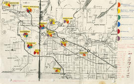
General overview of high-tech industry demographics
Part of City of Vancouver fonds
Item is a map annotated to show technology industry activities in Lower Mainland municipalities. Categories of activity are design/fabrication, system design/consulting, research/development, education, fabrication/manufacturing, and other. Item includes a list of the number of firms in each location.
![Vancouver's high-tech industry location map plus G.V.R.D. [Greater Vancouver Regional District] d...](/uploads/r/null/2/b/7/2b7c912f51dd7827d1a0ac60042357a631d2c8fdc3487bc37f286d2945c4ea4c/7a17e6a4-d593-45c5-9625-f03c471efb68-LEG1362_142.jpg)
Part of City of Vancouver fonds
Item is a map annotated to show locations of Vancouver technology firms. Categories of activity are system design/consulting, fabrication/manufacturing, design/fabrication, research/development, and other. Base map is a street map produced by the Engineering Department.
![[Group of people, including one nurse, in workshop]](/uploads/r/null/e/b/eb3c65f6f6575a881ac41a3849bdac75aa551c85f305902387a2e076508148e2/181e4849-686c-4529-97d2-37f43bfbc1b2-A47198_142.jpg)
[Group of people, including one nurse, in workshop]
Part of City of Vancouver fonds
![[Nurses and patients in hallway]](/uploads/r/null/a/b/ab8ed8d1ff2c790ba60dfda07befa87e7c3fed308a40a40163fdb48ac6ef6e62/6080a782-63ad-4c96-b1f1-1357a6764c59-A47199_142.jpg)
[Nurses and patients in hallway]
Part of City of Vancouver fonds
![[Empty hospital hallway]](/uploads/r/null/b/7/b7e31a09e2a979623029884c6c64fbdd2db963c96603c37ef6987cf4799e3b6b/ec3365c8-5236-46f9-9f39-b7ecfd168cb3-A47200_142.jpg)
Part of City of Vancouver fonds
![[Nurses standing by women in hospital beds]](/uploads/r/null/a/d/ad739bb4cf9ecdc3b7138bfe58274324ef7e6ca37b46ffea8c83e2a4f1d361f3/2e2baa0a-5152-4f61-b441-5d3ea584cae4-A47201_142.jpg)
[Nurses standing by women in hospital beds]
Part of City of Vancouver fonds
![[Exterior of hospital]](/uploads/r/null/a/7/a75de289032ec067262548708454091f6f6da099e423aefee5ec3eee7e0dbec2/6fabaf81-e99b-48ab-965d-636b92241d86-A47202_142.jpg)
Part of City of Vancouver fonds
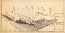
Preliminary plan for Vancouver Crematorium
Part of City of Vancouver fonds
Item is a diazotype print of an architectural drawing of the Vancouver Crematorium, Fraser Street and 41st Avenue.
Rhone & Iredale Architects

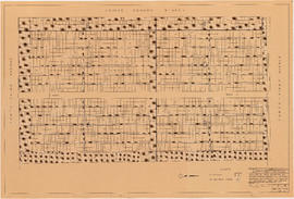
Mountain View Cemetery : proposed plan re conversion of pathways
Part of City of Vancouver fonds
Item is a copy of a portion of a map, which has been annotated to show pathways which are proposed to be converted to grave sites at Mountain View Cemetery, blocks 1-6, ranges 1-5.
![Abray section - conversion [of] pathways [Mountain View Cemetery]](/uploads/r/null/5/4/e/54ee58421d9f0e63fc174d29177384fc85458f48ea912dab4e63387f14e70e22/3602f9ee-31a1-4d28-80ad-8c9a6a8cdfbe-LEG1968_142.jpg)
Abray section - conversion [of] pathways [Mountain View Cemetery]
Part of City of Vancouver fonds
![Photograph [banquet at Empress Hotel]](/uploads/r/null/e/4/7/e473c20d7d5bd27643bda4ebb38dddf3ba18bb0dd37723f96ac6e2ed111c072f/9e9251ac-1a35-4698-8b49-923dc727c987-CVA325-1_142.jpg)
Photograph [banquet at Empress Hotel]
Part of City of Vancouver fonds
Photograph shows members of the Health Department dining in the Empress Hotel dining room at 235 East Hastings Street. Writing on the verso identifies the following; head of table: Dr. Underhill; left side: unidentified, Joe Pitman (Ch. Quar. Officer), Joe Hynes (Ch. Sar. Inspector), Ted Slevin, Sam Kinniston, George Rogers; right side: first six are unidentified, Joe Gibbs, and John Vance.

Part of City of Vancouver fonds


Part of City of Vancouver fonds

Part of City of Vancouver fonds


Part of City of Vancouver fonds

Part of City of Vancouver fonds

Aerial view of Vancouver City Hall and residential housing, facing east, on Cambie Street
Part of City of Vancouver fonds

Part of City of Vancouver fonds

Part of City of Vancouver fonds