Add to clipboard
General plan - sheet 5 [Arbutus Street to Twenty-third Avenue to Government Reserve to Twenty-ninth Avenue]
Add to clipboard
General plan - sheet 6 [Arbutus Street to Twenty-ninth Avenue to Government Reserve to Twenty-fifth Avenue]
Add to clipboard
General plan - sheet 7 [West Boulevard to Thirty-fifth Avenue to Government Reserve to Forty-first Avenue]
Add to clipboard
General plan - sheet 8 [West Boulevard to Forty-first Avenue to Musqueam Reserve to Forty-eighth Avenue]
Add to clipboard
General plan - sheet 9 [Arbutus Street to Forty-seventh Avenue to Musqueam Reserve to Fifty-third Avenue]
Add to clipboard
General plan - sheet 10 [Arbutus Street to Fifty-third Avenue to Musqueam Reserve to Fifty-ninth Avenue]
Add to clipboard
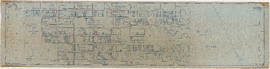
General plan - sheet 11 [Arbutus Street to Celtic Avenue to Fraser River]
Add to clipboard
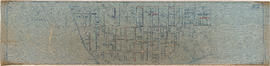
General plan - sheet 12 [Cambie Street to Sixteenth Avenue to Arbutus Street to Twenty-third Avenue]
Add to clipboard
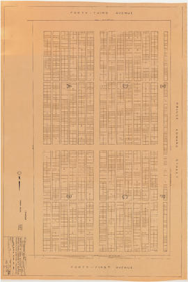
General plan - sheet 13 [Cambie Street to Twenty-third Avenue to East Boulevard to Twenty-ninth Avenue]
Add to clipboard
General plan - sheet 14 [Heather Street to Twenty-ninth Avenue to Arbutus Street to Thirty-fifth Avenue]
Add to clipboard
General plan - sheet 15 [Heather Street to Thirty-fifth Avenue to West Boulevard to Forty-first Avenue]
Add to clipboard
General plan - sheet 16 [Cambie Street to Forty-first Avenue to West Boulevard to Forty-seventh Avenue]
Add to clipboard
General plan - sheet 17 [Cambie Street to Forty-seventh Avenue to Arbutus Street to Fifty-third Avenue]
Add to clipboard
General plan - sheet 18 [Cambie Street to Dogwood Avenue to Arbutus Street to Sixtieth Avenue]
Add to clipboard
General plan - sheet 19 [Ash Street to Fifty-ninth Avenue to Arbutus Street to Sixty-seventh Avenue]
Add to clipboard
General plan - sheet 20 [Ash Street to Sixty-seventh Avenue to Arbutus Street to Seventy-third Avenue]
Add to clipboard
General plan - sheet 21 [Heather Street to Seventy-third Avenue to Fraser River]
Add to clipboard
Sewerage system : plan of Point Grey Municipality
Add to clipboard
Key plan showing Mountain View Cemetery, Vancouver, B.C.
Add to clipboard
Key plan showing Mountain View Cemetery, Vancouver, B.C.
Add to clipboard
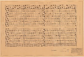
Portion of area bounded by 41st Avenue, Prince Edward Street & 43rd Avenue
Add to clipboard
Portion of area bounded by 41st Avenue, Prince Edward Street & 43rd Avenue
Add to clipboard
Skills : a controlled drinking program
Add to clipboard
Women and AIDS : A Human Rights Issue : Public Forum [panel]
Add to clipboard
[Aerial survey photograph]
Add to clipboard
[Aerial survey photograph with body of water]
Add to clipboard
[Aerial survey photograph]
Add to clipboard
[Aerial survey photograph]
Add to clipboard
[Aerial survey photograph with river]
Add to clipboard
Winch building
Add to clipboard
Yokohama presentation
Add to clipboard
General overview of high-tech industry demographics
Add to clipboard
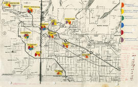
Vancouver's high-tech industry location map plus G.V.R.D. [Greater Vancouver Regional District] demographic of same as at Sept. 15, 1986
Add to clipboard
[Group of people, including one nurse, in workshop]
Add to clipboard
[Nurses and patients in hallway]
Add to clipboard
[Empty hospital hallway]
Add to clipboard
[Nurses standing by women in hospital beds]
Add to clipboard
[Exterior of hospital]
Add to clipboard
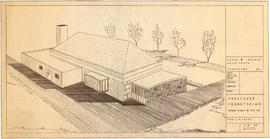
Preliminary plan for Vancouver Crematorium
Add to clipboard
Mountain View Cemetery : proposed plan re conversion of pathways
Add to clipboard
Abray section - conversion [of] pathways [Mountain View Cemetery]
Add to clipboard
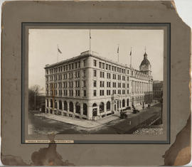
Photograph [banquet at Empress Hotel]
Add to clipboard
Aerial view of Strathcona to Downtown, with Georgia Viaduct, False Creek, Canadian Central Station and Canadian Western Cooperage sawmill
Add to clipboard
Aerial view of Downtown Vancouver, West End and Yaletown, with Granville Street Bridge and Burrard Street Bridge, and C.P.R. [Canadian Pacific Railway] train yards
Add to clipboard
Aerial view of Mount Pleasant and False Creek, at Main Street and 2nd Avenue, with Canadian Central Station and Opsal Steel
Add to clipboard
Aerial view of False Creek, Fairview and Granville Island, at Lamey's Mill Road, West 6th Avenue and Birch Street, with Granville Street Bridge
Add to clipboard
Aerial view of Strathcona, between Jackson and Gore Avenues at Prior, with Canadian Pacific Railway train yards, Lord Strathcona Elementary, Oppenheimer Park, First United Church and St. James Anglican Church
Add to clipboard
Aerial view of Vancouver City Hall and residential housing, at Cambie Street and 12th Avenue, with Model and Normal School (City Square Mall) and Blessed Sacrament Parish
Add to clipboard
Aerial view of Fairview at the foot of Granville Street Bridge, with Granville Island and industrial buildings
Add to clipboard
Aerial view of False Creek at Cambie Street Bridge and 2nd Avenue with Canadian Western Cooperage sawmill


![General plan - sheet 11 [Arbutus Street to Celtic Avenue to Fraser River]](/uploads/r/null/3/f/d/3fd9a37e7d563f1ab5ea2d9d72418a55895d86310b0a78eab48407b8b835b701/136e3b9b-509e-4f21-94e7-d53135afd227-LEG1153_142.jpg)
![General plan - sheet 12 [Cambie Street to Sixteenth Avenue to Arbutus Street to Twenty-third Avenue]](/uploads/r/null/8/5/f/85f228499ffefb33a4420336b35885201d899673637daca6b1eebd8fd0111f3e/4ee908fd-0dfa-4297-8198-99592dee3c2b-LEG1153_142.jpg)


![General plan - sheet 18 [Cambie Street to Dogwood Avenue to Arbutus Street to Sixtieth Avenue]](/uploads/r/null/7/3/0/730edd4b5bb09f437c0bf207248dd5623603f3054a8b42c57e71efc48dbc508f/3aa6b0df-f6ac-4001-92db-28b342873388-LEG1153_142.jpg)
![General plan - sheet 19 [Ash Street to Fifty-ninth Avenue to Arbutus Street to Sixty-seventh Avenue]](/uploads/r/null/c/d/9/cd91342eba2fda61236d03f55e1772cfcacc898fda7f2de3b55408ad37e4f618/ab184e33-c017-49fd-8425-47302485efcc-LEG1153_142.jpg)
![General plan - sheet 21 [Heather Street to Seventy-third Avenue to Fraser River]](/uploads/r/null/d/1/6/d1697104a1a4279099944caca836ec97365dd22d65bd611490ee71828ae0ce96/5bf4af24-c2fe-477e-a13d-1ba1c9107389-LEG1153_142.jpg)


![Women and AIDS : A Human Rights Issue : Public Forum [panel]](/uploads/r/null/5/2/4/5247bb62488336bffd4c69c650279e073b62245601c64911ffb317fe92e17894/0aebc6bd-c75f-41c7-9921-60f1b3abc64a-LEG2219_142.jpg)
![[Aerial survey photograph]](/uploads/r/null/f/a/fab195a7fc233deb2d6de7cd7adbb1c17e581561907ad4326ec3e70802b8053e/7186442f-d249-4e5f-9aca-ac698f0376fd-A40953_142.jpg)
![[Aerial survey photograph with body of water]](/uploads/r/null/0/8/08c3cd4f3f862932c7f8892684151a7b8147e1d257a9a70930541c72b57f2f9b/348a6a46-4362-459e-ac8b-e210bffcfe4f-A40990_142.jpg)
![[Aerial survey photograph]](/uploads/r/null/8/6/86329ac6a4aa2d72519aa3411a56ef7fc696546a8bd1c916228309a90e76067a/889ed9ec-97c7-4317-9c11-53a8c123430d-A40954_142.jpg)
![[Aerial survey photograph]](/uploads/r/null/5/d/5d61d720b2a88dce52e09ab49a7ef4942b0eac1405c7b4e765e3beda6f25999a/b0d55cc5-84f3-47e9-919c-a036db614315-A48057_142.jpg)
![[Aerial survey photograph with river]](/uploads/r/null/f/e/fe98d2abefe97f551eec30eb0326bbb273e1ee059396e9f6909ffc1984a9f7ea/6786642e-fcc8-4f00-bf6d-26d122fae5ec-A38258_142.jpg)
![Vancouver's high-tech industry location map plus G.V.R.D. [Greater Vancouver Regional District] d...](/uploads/r/null/2/b/7/2b7c912f51dd7827d1a0ac60042357a631d2c8fdc3487bc37f286d2945c4ea4c/7a17e6a4-d593-45c5-9625-f03c471efb68-LEG1362_142.jpg)
![[Group of people, including one nurse, in workshop]](/uploads/r/null/e/b/eb3c65f6f6575a881ac41a3849bdac75aa551c85f305902387a2e076508148e2/181e4849-686c-4529-97d2-37f43bfbc1b2-A47198_142.jpg)
![[Nurses and patients in hallway]](/uploads/r/null/a/b/ab8ed8d1ff2c790ba60dfda07befa87e7c3fed308a40a40163fdb48ac6ef6e62/6080a782-63ad-4c96-b1f1-1357a6764c59-A47199_142.jpg)
![[Empty hospital hallway]](/uploads/r/null/b/7/b7e31a09e2a979623029884c6c64fbdd2db963c96603c37ef6987cf4799e3b6b/ec3365c8-5236-46f9-9f39-b7ecfd168cb3-A47200_142.jpg)
![[Nurses standing by women in hospital beds]](/uploads/r/null/a/d/ad739bb4cf9ecdc3b7138bfe58274324ef7e6ca37b46ffea8c83e2a4f1d361f3/2e2baa0a-5152-4f61-b441-5d3ea584cae4-A47201_142.jpg)
![[Exterior of hospital]](/uploads/r/null/a/7/a75de289032ec067262548708454091f6f6da099e423aefee5ec3eee7e0dbec2/6fabaf81-e99b-48ab-965d-636b92241d86-A47202_142.jpg)

![Abray section - conversion [of] pathways [Mountain View Cemetery]](/uploads/r/null/5/4/e/54ee58421d9f0e63fc174d29177384fc85458f48ea912dab4e63387f14e70e22/3602f9ee-31a1-4d28-80ad-8c9a6a8cdfbe-LEG1968_142.jpg)
![Photograph [banquet at Empress Hotel]](/uploads/r/null/e/4/7/e473c20d7d5bd27643bda4ebb38dddf3ba18bb0dd37723f96ac6e2ed111c072f/9e9251ac-1a35-4698-8b49-923dc727c987-CVA325-1_142.jpg)


