![[School buidling]](/uploads/r/null/f/2/7/f27a9956597ed3eab185566751e605bf55af03aa3414c945f834b796d187c117/d78b3793-55c1-4306-909a-46b53b064c4c-CVA1095-08698_142.jpg)
- COV-S644-: CVA 1095-08698
- Item
- Aug. 1974
Part of City of Vancouver fonds
Part of City of Vancouver fonds
![[School buidling]](/uploads/r/null/4/1/d/41d180811de4ef150e9fc20cbf7713ab4a27b51a03f02ed12164b22e4ad4b47f/8bca8e93-bc97-42e0-a7ad-fa3bccedcee8-CVA1095-08699_142.jpg)
Part of City of Vancouver fonds
![Bayview [Elementary] School [at 2251 Collingwood Street and] W[est] 6th [Avenue]](/uploads/r/null/7/c/7c80d8e080da3f0745622eed50eb94999f780594860ca265b3ae99429bab00e3/317e50c5-8054-47e6-98df-abd9b80e7bbe-A58925_142.jpg)
Bayview [Elementary] School [at 2251 Collingwood Street and] W[est] 6th [Avenue]
Part of City of Vancouver fonds
Photograph also shows the playground area after improvements
![Henry Hudson [Elementary] School [at 1551 Cypress Street]](/uploads/r/null/5/5/5558d20cb85309ca9ec5d4ebfe8312783a23a61958cb7404707249ebe0b67947/b111f9c1-0d79-433a-b60d-b770808a7361-A58957_142.jpg)
Henry Hudson [Elementary] School [at 1551 Cypress Street]
Part of City of Vancouver fonds
![[Henry] Hudson [Elementary] School [at 1551 Cypress Street]](/uploads/r/null/0/2/02daa6531376a535dff9bb9e4f40c98c06be0fe4912be872010e00565aa25e6e/1763ebc4-89d0-43a3-b817-96de6051cbe0-A58958_142.jpg)
[Henry] Hudson [Elementary] School [at 1551 Cypress Street]
Part of City of Vancouver fonds
![Bayview [Elementary] School [at 2251 Collingwood Street]](/uploads/r/null/8/4/84146e68cd846eeeaae7e2bd5b42caedb758a2b24321969f1526b2cf31663f39/ec8a093d-2991-41d4-ae38-c216a26dc428-A58959_142.jpg)
Bayview [Elementary] School [at 2251 Collingwood Street]
Part of City of Vancouver fonds
![Bayview [Elementary] School [at 2251 Collingwood Street]](/uploads/r/null/6/9/69766eb65a9e2ee872207bc935f99ec47ae460557c96055707ca0cc60e3c41f1/2d87f4d6-bc65-4818-ad9f-45745a213a5c-A58960_142.jpg)
Bayview [Elementary] School [at 2251 Collingwood Street]
Part of City of Vancouver fonds
![Bayview [Elementary] School [at 2251 Collingwood Street]](/uploads/r/null/1/b/1b35ea4cd1007e2267edc0154384a822061ebc5b88dcd18b351a1ea125677f9d/26305ca1-fa35-44fe-9f22-4aa5146f5e2c-A58963_142.jpg)
Bayview [Elementary] School [at 2251 Collingwood Street]
Part of City of Vancouver fonds
![Bayview [Elementary] School [at 2251 Collingwood Street]](/uploads/r/null/2/d/2d225ed6570ec985812b9595c80d96781d4ca9ab544030f0b6f58178f59b9748/f558ec73-d4a1-4c64-911f-b92f064f3abf-A58964_142.jpg)
Bayview [Elementary] School [at 2251 Collingwood Street]
Part of City of Vancouver fonds
Photograph also shows a mural on the exterior wall of the school
![[Kitsilano] Comm[unity] Cent[re] and Ice Rink [at 2495 West 12th Avenue]](/uploads/r/null/d/9/d9d761b639f1d0ac4a01b48249a9f15db50161c1906b66a8a6f3bd78fae21c89/69059b05-f0ca-4d67-903f-216fd4844af0-A58965_142.jpg)
[Kitsilano] Comm[unity] Cent[re] and Ice Rink [at 2495 West 12th Avenue]
Part of City of Vancouver fonds
Photograph also shows Connaught Park, the Greater Vancouver Regl, Sewage and Drainage and Water District (2294 West 10th Avenue), and apartment buildings at 2285 West 10th Avenue (Patna Apartments) and 2586 Vine Street
![[Kitsilano] Ice Rink [at 2495 West 12th Avenue]](/uploads/r/null/e/b/eb721478621e4bda9a57c84a63bed97f2584c3d59a11c99b4a350144e51252bd/dc26c67f-7ca8-4fe5-807c-7e3c8c3c65dc-A58967_142.jpg)
[Kitsilano] Ice Rink [at 2495 West 12th Avenue]
Part of City of Vancouver fonds
Photograph also shows Connaught Park, the Greater Vancouver Regl, Sewage and Drainage and Water Distict (2294 West 10th Avenue), and apartment buildings 2285 West 10th Avenue (Patna Apartments) and 2586 Vine Street
![[Kitsilano Secondary School at 2550 West 10th Avenue]](/uploads/r/null/d/9/d948ed1b439eeea7151c09ff01708341f7f3bb8e611fe5a482b710adfb176524/994d8698-c7b5-4606-b8bb-bf8fe56e95d9-A58969_142.jpg)
[Kitsilano Secondary School at 2550 West 10th Avenue]
Part of City of Vancouver fonds
![[View of] Mount Pleasant School [370 East Broadway from East 10th Avenue and Kingsway]](/uploads/r/null/4/a/4a9c17ea5d268fc17a0c524e5a734a8b8f6233d37b48b2dcecf9afea9c5c9598/908742d8-8944-4b01-ae91-cc8033daa91a-A59088_142.jpg)
[View of] Mount Pleasant School [370 East Broadway from East 10th Avenue and Kingsway]
Part of City of Vancouver fonds
Photograph shows the back of the school facing Kingsway and East 10th Avenue.
![Simon Fraser [Elementary] School [at] 3185 Manitoba [Street]](/uploads/r/null/c/e/ceb7f0a743608fb0d43a03fedf7e0accac463f28944ff1fd2e6fb5ec70f58488/ec148232-5579-42c1-ac42-8a85607ed3de-A59091_142.jpg)
Simon Fraser [Elementary] School [at] 3185 Manitoba [Street]
Part of City of Vancouver fonds
![St. Patrick's School [at] 2850 Quebec [Street]](/uploads/r/null/a/7/a78a7cdf297024f8481e2a4b3e81252c4c47b3f178dea1395351111a530c7fe1/93aed1ab-0454-4963-84f4-b51be040d098-A59092_142.jpg)
St. Patrick's School [at] 2850 Quebec [Street]
Part of City of Vancouver fonds
![Shaughn[essy Elementary] School [at 4250 Marguerite Street]](/uploads/r/null/6/a/6af8bd8506d9332ec561ec9a2b132e98867e98b7d4c797370c6c707534cb8634/f3bdba72-facf-45ab-b3ab-e5a38a7d486e-A59154_142.jpg)
Shaughn[essy Elementary] School [at 4250 Marguerite Street]
Part of City of Vancouver fonds
![[The Vancouver] Chinese Public School [at] 499 E[ast] Pender [Street]](/uploads/r/null/9/a/9a4d898a4390e8a2cc895d51a65b2329c57ef923bce8139f2a23201e1392e2ce/dbe7f86b-7921-47b8-954b-5132f9ab67f3-A59159_142.jpg)
[The Vancouver] Chinese Public School [at] 499 E[ast] Pender [Street]
Part of City of Vancouver fonds
![[Pender Street looking west from Strathcona School in] Strathcona](/uploads/r/null/6/d/6d8d50423b1d5d23c3f7b45d7a7a107f2c7f46c2fac2c54989f42b537b6879e8/681b6d46-eea2-437b-b7a5-d8b97ceb7504-A59203_142.jpg)
[Pender Street looking west from Strathcona School in] Strathcona
Part of City of Vancouver fonds
Photograph also shows the Chinese Public School, 499 E Pender in the background.
![Lord Roberts [Elementary School at 1100 Bidwell Street]](/uploads/r/null/c/8/c80de33ddcbcb56b0ed17b085262ef345a0ea8df500e3a7a2cfed4524a97bcbd/8187188b-ff56-4be4-b2ab-1306ac547656-A59257_142.jpg)
Lord Roberts [Elementary School at 1100 Bidwell Street]
Part of City of Vancouver fonds
Photograph shows the back of the school
![Lord Roberts [Elementary School at 1100 Bidwell Street]](/uploads/r/null/3/a/3a0322ec0a824708f4845f0190a771528c27e9badb265e6c2b258265cadca615/3efbe786-0114-42d7-b97d-981d41e3cff2-A59258_142.jpg)
Lord Roberts [Elementary School at 1100 Bidwell Street]
Part of City of Vancouver fonds
Photograph shows the back of the school
![Jericho Hill School [at 4125 West 8th Avenue]](/uploads/r/null/3/e/3ea990ff4d37986d60d406cfbafa91fdb15eb1ddcb9c79deeee2f02fc6a013bd/5840df8c-af1f-4c50-aa22-51bb9a1c0b96-A59296_142.jpg)
Jericho Hill School [at 4125 West 8th Avenue]
Part of City of Vancouver fonds

Sequoia sempervirens, Point Grey School
Part of City of Vancouver fonds

Sequoia sempervirens, Point Grey School
Part of City of Vancouver fonds

Part of City of Vancouver fonds
Item is a map showing locations of elementary, junior high, junior-senior high, and senior high schools in Vancouver. Map has been annotated with blue and red check marks next to some schools, but lacks explanation of what the marks mean.

Sheet 1 : Slocan Street to Boundary Road and Triumph Street to Burrard Inlet
Part of City of Vancouver fonds
Item is a section showing the area bound by Slocan Street, Boundary Road, Triumph Street and the waterfront. Includes streets, roads, railways, blocks, lots, legal descriptions, quit claims, leases, parks and businesses along the waterfront. Section is annotated in colour to show tax sale property for sale, property with no water, street widening and drainage, replotting, reserved land for schools, reserved land for parks, sundry land, capital assets not including schools and parks, schools, and parks, as applicable.
Vancouver (B.C.). Office of the City Engineer

Sheet 2 : Slocan Street to Boundary Road and Charles Street to Triumph Street
Part of City of Vancouver fonds
Item is a section showing the area from Slocan Street to Boundary Road and Charles Street to Triumph Street. Includes streets, roads, blocks, lots, legal descriptions, parks, schools, and retirement homes. Section is annotated in colour to show tax sale property for sale, property with no water, street widening and drainage, replotting, reserved land for schools, reserved land for parks, sundry land, capital assets not including schools and parks, schools, and parks, as applicable.
Vancouver (B.C.). Office of the City Engineer

Sheet 3 : Slocan Street to Boundary Road and Seventh Avenue to Charles Street
Part of City of Vancouver fonds
Item is a section showing the area from Slocan Street to Boundary Road and Seventh Avenue to Charles Street. Includes streets and roads, blocks, lots, legal descriptions, parks and schools. Map is hand coloured to show tax sale property for sale, property with no water, street widening and drainage, replotting, reserved land for schools, reserved land for parks, sundry land, capital assets not including schools and parks, schools, and parks, as applicable.
Vancouver (B.C.). Office of the City Engineer
Sheet 4 : Slocan Street to Boundary Road and Seventh Avenue to Seventeenth Avenue
Part of City of Vancouver fonds
Item is a section showing the area from Slocan Street to Boundary Road and Seventh Avenue to Seventeenth Avenue. Map is hand coloured to show tax sale property for sale, property with no water, street widening and drainage, replotting, reserved land for schools, reserved land for parks, sundry land, capital assets not including schools and parks, schools, and parks, as applicable. Includes streets and roads, blocks, lots, legal descriptions, railways, parks and schools.
Vancouver (B.C.). Office of the City Engineer

Sheet 5 : Slocan Street to Boundary Road and Seventeenth Avenue to Twenty-ninth Avenue
Part of City of Vancouver fonds
Item is a section showing the area from Slocan Street to Boundary Road and Seventeenth Avenue to Twenty-ninth Avenue. Includes streets and roads, blocks, lots, legal descriptions, railways, parks, schools and the Vancouver Preventorium (for tuberculosis patients). Some annotations have been made in pencil. Map is hand coloured to show tax sale property for sale, property with no water, street widening and drainage, replotting, reserved land for schools, reserved land for parks, sundry land, capital assets not including schools and parks, schools, and parks, as applicable.
Vancouver (B.C.). Office of the City Engineer

Sheet 6 : Knight Street to Slocan Street and Eighteenth Avenue to Twenty-ninth Avenue
Part of City of Vancouver fonds
Item is a section showing the area from Knight Street to Slocan Street and Eighteenth Avenue to Twenty-ninth Avenue. Includes streets and roads, blocks, lots, legal descriptions, railways, parks and schools. Some annotations have been made in pencil. Map is hand coloured to show tax sale property for sale, property with no water, street widening and drainage, replotting, reserved land for schools, reserved land for parks, sundry land, capital assets not including schools and parks, schools, and parks. Map is hand coloured to show tax sale property for sale, property with no water, street widening and drainage, replotting, reserved land for schools, reserved land for parks, sundry land, capital assets not including schools and parks, schools, and parks, as applicable.
Vancouver (B.C.). Office of the City Engineer

Sheet 7 : Clark Drive to Slocan Street and Seventh Avenue to Eighteenth Avenue
Part of City of Vancouver fonds
Item is a section showing the area from Clark Drive to Slocan Street and Seventh Avenue to Eighteenth Avenue. Includes streets and roads, blocks, lots, legal descriptions, railways, parks and schools. Map is hand coloured to show tax sale property for sale, property with no water, street widening and drainage, replotting, reserved land for schools, reserved land for parks, sundry land, capital assets not including schools and parks, schools, and parks, as applicable.
Vancouver (B.C.). Office of the City Engineer

Sheet 8 : McLean Drive to Slocan Street and William Street to Seventh Avenue
Part of City of Vancouver fonds
Item is a section showing the area from McLean Drive to Slocan Street and William Street to Seventh Avenue. Includes streets and roads, blocks, lots, legal descriptions, railways, parks, schools and some businesses. Map is hand coloured to show tax sale property for sale, property with no water, street widening and drainage, replotting, reserved land for schools, reserved land for parks, sundry land, capital assets not including schools and parks, schools, and parks, as applicable. Some annotations have been made in pencil.
Vancouver (B.C.). Office of the City Engineer

Sheet 9 : Clark Drive to Slocan Street and Triumph Street to Charles Street
Part of City of Vancouver fonds
Item is a section showing the area from Clark Drive to Slocan Street and Triumph Street to Charles Street. Includes streets and roads, blocks, lots, legal descriptions, railways, parks, schools and drill hall. The Town of Hastings is indicated on the map. Some annotations have been made in pencil. Map is hand coloured to show tax sale property for sale, property with no water, street widening and drainage, replotting, reserved land for schools, reserved land for parks, sundry land, capital assets not including schools and parks, schools, and parks, as applicable.
Vancouver (B.C.). Office of the City Engineer

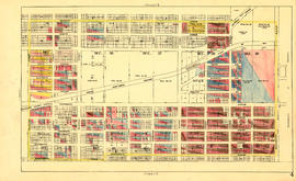
Sheet 11 : Carrall Street to Clark Drive and waterfront to Keefer Street
Part of City of Vancouver fonds
Item is a section showing the area from Carrall Street to Clark Drive and waterfront to Keefer Street. Includes streets and roads, blocks, lots, legal descriptions, railways, parks, schools, freight sheds, warehouses, piers and businesses along the waterfront.Map is hand coloured to show tax sale property for sale, property with no water, street widening and drainage, replotting, reserved land for schools, reserved land for parks, sundry land, capital assets not including schools and parks, schools, and parks, as applicable.
Vancouver (B.C.). Office of the City Engineer

Sheet 12 : Ontario Street to Clark Drive and Keefer Street to Second Avenue
Part of City of Vancouver fonds
Item is a section showing the area from Ontario Street to Clark Drive and Keefer Street to Second Avenue. Includes streets, roads, blocks, lots, legal descriptions, railways, parks and schools. Includes Terminal Avenue and land used by the Great Northern Railway and the Canadian National Railway. Map is hand coloured to show tax sale property for sale, property with no water, street widening and drainage, replotting, reserved land for schools, reserved land for parks, sundry land, capital assets not including schools and parks, schools, and parks, as applicable.
Vancouver (B.C.). Office of the City Engineer

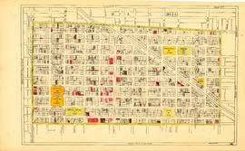
Sheet 13 : Ontario Street to Clark Drive and First Avenue to Sixteenth Avenue
Part of City of Vancouver fonds
Item is a section showing the area from Ontario Street to Clark Drive and First Avenue to Sixteenth Avenue. Includes streets, roads, blocks, lots, legal descriptions, railways, parks and schools. Includes B.C. Electric Railway car barns. Map is hand coloured to show tax sale property for sale, property with no water, street widening and drainage, replotting, reserved land for schools, reserved land for parks, sundry land, capital assets not including schools and parks, schools, and parks. Annotations in pencil.
Vancouver (B.C.). Office of the City Engineer
Sheet 14 : Main Street to Knight Street and Fifteenth Avenue to King Edward Street
Part of City of Vancouver fonds
Item is a section showing the area from Main Street to Knight Street and Fifteenth Avenue to King Edward Street. Includes streets and roads, blocks, lots, legal descriptions, parks, schools and businesses. Map is hand coloured to show tax sale property for sale, property with no water, street widening and drainage, replotting, reserved land for schools, reserved land for parks, sundry land, capital assets not including schools and parks, schools, and parks.
Vancouver (B.C.). Office of the City Engineer

Sheet 15 : Oak Street to Main Street and False Creek to Sixteenth Avenue
Part of City of Vancouver fonds
Item is a section showing Oak Street to Main Street and False Creek to Sixteenth Avenue. Includes streets and roads, blocks, lots, legal descriptions, railways, schools, monastery, Vancouver General Hospital and City Hall. Indicates crown land leased to the C.P.R. Map is hand coloured to show tax sale property for sale, property with no water, street widening and drainage, replotting, reserved land for schools, reserved land for parks, sundry land, capital assets not including schools and parks, schools, and parks.
Vancouver (B.C.). Office of the City Engineer

Sheet 16 : Maple Street to Oak Street and False Creek to Sixteenth Avenue
Part of City of Vancouver fonds
Item is a section showing Maple Street to Oak Street and False Creek to Sixteenth Avenue. Includes streets and roads, blocks, lots, legal descriptions, railways, schools and parks. Indicates crown land leased to the C.P.R. and other bodies. Map is hand coloured to show tax sale property for sale, property with no water, street widening and drainage, replotting, reserved land for schools, reserved land for parks, sundry land, capital assets not including schools and parks, schools, and parks.
Vancouver (B.C.). Office of the City Engineer

Sheet 17 : Trutch Street to Maple Street and Fourth Avenue to Sixteenth Avenue
Part of City of Vancouver fonds
Item is a section showing Trutch Street to Maple Street and Fourth Avenue to Sixteenth Avenue. Includes streets, roads, blocks, lots, legal descriptions, parks and schools. Annotations in pencil. Map is hand coloured to show tax sale property for sale, property with no water, street widening and drainage, replotting, reserved land for schools, reserved land for parks, sundry land, capital assets not including schools and parks, schools, and parks.
Vancouver (B.C.). Office of the City Engineer

Sheet 19 : Maple Street to Richards Street and Drake Street to Third Avenue
Part of City of Vancouver fonds
Item is a section showing Maple Street to Richards Street and Drake Street to Third Avenue. Includes streets, roads, blocks, lots, legal descriptions, parks, schools, the Burrard and Granville Street Bridges, C.P.R. right-of-ways, the Squamish Band reserve, C.P.R. leases and property, and government reserve. Map includes Granville Island. Map is hand coloured to show tax sale property for sale, property with no water, street widening and drainage, replotting, reserved land for schools, reserved land for parks, sundry land, capital assets not including schools and parks, schools, and parks.
Vancouver (B.C.). Office of the City Engineer

Sheet 21 : Burrard Street to False Creek and waterfront to Robson Street
Part of City of Vancouver fonds
Item is a section showing Burrard Street to False Creek and waterfront to Robson Street. Includes streets and roads; blocks, lots and legal descriptions; the locations of hotels, court house, businesses, parks, and schools; crown leases; C.P.R. land and the company's Piers B and C, yards, sheds and depot; the B.C. Electric Railway Carrall Street Yard; and the Union Steamship Company. Map is hand coloured to show tax sale property for sale, property with no water, street widening and drainage, replotting, reserved land for schools, reserved land for parks, sundry land, capital assets not including schools and parks, schools, and parks, as applicable.
Vancouver (B.C.). Office of the City Engineer

Sheet 23 : Stanley Park to Granville Street and Robson Street to False Creek
Part of City of Vancouver fonds
Item is a section showing the area from Stanley Park to Granville Street and Robson Street to False Creek. Includes streets, roads and railways; blocks, lots and legal descriptions; as well as parks, schools, hospitals and churches. Shows the Burrard Bridge and C.P.R. property. Map is hand coloured to show tax sale property for sale, property with no water, street widening and drainage, replotting, reserved land for schools, reserved land for parks, sundry land, capital assets not including schools and parks, schools, and parks, as applicable.
Vancouver (B.C.). Office of the City Engineer

Sheet B : Imperial Street to Trutch Street and waterfront to Fourth Avenue
Part of City of Vancouver fonds
Item is a section showing the area from Imperial Street to Trutch Street and waterfront to Fourth Avenue. Includes streets, roads and sewers; blocks, lots and legal descriptions; and parks and schools. Section shows Jericho Air Station and crown leases. Map is annotated to show tax sale property for sale, property with no water, street widening and drainage, replotting, reserved land for schools, reserved land for parks, sundry land, capital assets not including schools and parks, schools, and parks, as applicable.
Vancouver (B.C.). Office of the City Engineer

Sheet C : University Endowment Lands to Imperial Street and Fourth Avenue to Sixteenth Avenue
Part of City of Vancouver fonds
Item is a section showing the area from the University Endowment Lands to Imperial Street and Fourth Avenue to Sixteenth Avenue. Includes streets, roads, blocks, lots, legal descriptions, parks and schools. Section is annotated to show tax sale property for sale, property with no water, street widening and drainage, replotting, reserved land for schools, reserved land for parks, sundry land, capital assets not including schools and parks, schools, and parks, as applicable.
Vancouver (B.C.). Office of the City Engineer

Sheet D : Imperial Street to Trutch Street and Fourth Avenue to Sixteenth Avenue
Part of City of Vancouver fonds
Item is a section showing the area from Imperial Street to Trutch Street and Fourth Avenue to Sixteenth Avenue. Includes streets and roads; blocks; lots and legal descriptions; and parks, schools and golf courses. Section is annotated to show tax sale property for sale, property with no water, street widening and drainage, replotting, reserved land for schools, reserved land for parks, sundry land, capital assets not including schools and parks, schools, and parks, as applicable.
Vancouver (B.C.). Office of the City Engineer

Sheet E : University Endowment Lands to Wallace Street and Sixteenth Avenue to Twenty-seventh Avenue
Part of City of Vancouver fonds
Item is a section showing the area from Wallace Street to Trafalgar Street and Sixteenth Avenue to Twenty-seventh Avenue. Includes streets, roads, blocks, lots, legal descriptions, parks and schools. Section is annotated to show tax sale property for sale, property with no water, street widening and drainage, replotting, reserved land for schools, reserved land for parks, sundry land, capital assets not including schools and parks, schools, and parks, as applicable.
Vancouver (B.C.). Office of the City Engineer

Sheet F : Wallace Street to Trafalgar Street and Sixteenth Avenue to Twenty-seventh Avenue
Part of City of Vancouver fonds
Item is a section showing the area from Wallace Street to Trafalgar Street and Sixteenth Avenue to Twenty-seventh Avenue. Includes streets, roads, blocks, lots, legal descriptions, parks and schools. Section is annotated to show tax sale property for sale, property with no water, street widening and drainage, replotting, reserved land for schools, reserved land for parks, sundry land, capital assets not including schools and parks, schools, and parks, as applicable.
Vancouver (B.C.). Office of the City Engineer

Sheet G : Trafalgar Street to Granville Street and Sixteenth Avenue to Nanton Avenue
Part of City of Vancouver fonds
Item is a section showing the area from Trafalgar Street to Granville Street and Sixteenth Avenue to Nanton Avenue. Includes streets, roads and sewers; blocks, lots and legal descriptions; and parks, railway lines and schools. Section is annotated to show tax sale property for sale, property with no water, street widening and drainage, replotting, reserved land for schools, reserved land for parks, sundry land, capital assets not including schools and parks, schools, and parks, as applicable.
Vancouver (B.C.). Office of the City Engineer

Sheet H : Alexandra Street to Cambie Street and Fifteenth Avenue to Twenty-seventh Avenue
Part of City of Vancouver fonds
Item is a section showing the area from Alexandra Street to Cambie Street and Fifteenth Avenue to Twenty-seventh Avenue. Includes streets, roads, blocks, lots, legal descriptions, parks, hospitals and schools. Section is annotated to show tax sale property for sale, property with no water, street widening and drainage, replotting, reserved land for schools, reserved land for parks, sundry land, capital assets not including schools and parks, schools, and parks, as applicable.
Vancouver (B.C.). Office of the City Engineer