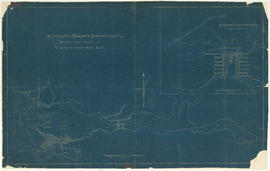
Suggested harbour improvements Burrard Inlet
- COV-S365-: LEG1967.05
- Item
- [191-?]
Part of City of Vancouver fonds
20 results with digital objects Show results with digital objects
Suggested harbour improvements Burrard Inlet
Part of City of Vancouver fonds

Part of City of Vancouver fonds
Item shows Point Grey harbour facilities and industrial lands, the Jericho naval reserve and golf links through a combination of a map and illustrations. A smaller key plan shows the location of the Vancouver Terminals Company's harbour properties in relation to the rest of Point Grey and Vancouver.

Part of City of Vancouver fonds
Item is a map prepared as part of the Harbour Headline project of the False Creek Development Study. Map shows existing, interim and ultimate harbour headlines, existing water areas, ownership boundaries, other property lines and lease boundaries in and around False Creek.
![[Northwest facing cityscape view of the West End]](/uploads/r/null/8/1/8144b464121d2d606915a295fe4bfea95b903893f4ac909e59d22d27b3a6c7db/c58f4286-e96d-4189-ad75-9885f1b17ff7-A59249_142.jpg)
[Northwest facing cityscape view of the West End]
Part of City of Vancouver fonds
Photograph also shows buildings in the West End, English Bay, Stanley Park, Coal Harbour, Burrard Inlet, and the North Shore
![[Southwest facing cityscape view of the West End]](/uploads/r/null/4/b/4b50b8139a75294378d4e28c633eb1a7201b7a1ffba30b79f1cf631026c1a7bd/4f7badb7-4d85-4c22-8780-a7311c11a932-A59250_142.jpg)
[Southwest facing cityscape view of the West End]
Part of City of Vancouver fonds
Photograph also shows English Bay
![[North facing cityscape view of the West End showing the] Sheraton-Landmark](/uploads/r/null/7/d/7db38a96995179fe1118994e0c35380cbd8d1bc5909f43a9cb352ba83ea17b88/9e677767-fb6d-4420-91d8-8152f5d4ede1-A59252_142.jpg)
[North facing cityscape view of the West End showing the] Sheraton-Landmark
Part of City of Vancouver fonds
Photograph also shows Coal Harbour and the North Shore

Vancouver Harbour, foot of Cardero Street
Part of City of Vancouver fonds
Item is a photograph showing boats in the harbour at the foot of Cardero Street. Boats shown include the "Victorac" and the "Reel Fisher".
Part of City of Vancouver fonds
Item is a documentary film documenting the transportation and population issues that impact access to downtown Vancouver. Film contains scenes of driving on the Granville Street Bridge, people attending a show, on a beach and walking around city streets at both daytime and evening.
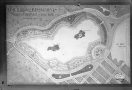
Coal Harbour Improvements Suggested Treatment of Inner Basin
Part of City of Vancouver fonds
Photograph shows map of suggested improvements.
![[Coal Harbour view from Denman Street]](/uploads/r/null/f/4/f4ee6b5b8d147b8a774a97a7b59f6f8c29bb8792a52da1695f47dce307742555/f90773a4-4b21-478d-bd42-505e1d441b47-A16624_142.jpg)
[Coal Harbour view from Denman Street]
Part of City of Vancouver fonds
![[Coal Harbour]](/uploads/r/null/e/6/e641a81bbc0d7d8adfb51e6e32ecb57659f5dccdce517fb88dd14160144e3e52/c67b13d2-e877-4fb3-8b2f-0de875c9280a-A16625_142.jpg)
Part of City of Vancouver fonds
![[Coal Harbour]](/uploads/r/null/8/3/83bd003a993aaa90a0c6aea33d3521bf9163833f067d66579783658045125695/447583bd-7a62-4edd-9558-f0bcaf009c90-A16626_142.jpg)
Part of City of Vancouver fonds
![[Coal Harbour?]](/uploads/r/null/b/4/b488b986b859b20d49e5b4d6f59cb320223b0da4668774c67790e46f15e737a7/ea0b239a-5c45-449d-80f0-04a4483b3cd5-A16627_142.jpg)
Part of City of Vancouver fonds
Photograph shows marsh and water with gazebo in background.
![[Coal Harbour?]](/uploads/r/null/d/b/db2de6c93437b31527635deddfa2d1b0228f1dfd0d78c0bf6d754fd685fc663b/dccf9129-e23d-46e6-8e3f-0adde1d833b8-A16628_142.jpg)
Part of City of Vancouver fonds
Photograph shows marsh and water with gazebo in background.
![[Coal Harbour?]](/uploads/r/null/1/c/1c43ca1c74017572cccbbeb20b07dae64a1d3dc2d6ed6573e3555df279535121/dee93f4d-4cde-4f0b-b504-dfb863bfa77d-A16629_142.jpg)
Part of City of Vancouver fonds
Photograph shows water, bridge, and houses.
![[Coal Harbour?]](/uploads/r/null/f/b/fb269570031b2a3828f329c97b9db78a5236f47cf4286fb78bf3c2058c53b0de/626b353c-ab4a-4c40-bcaf-41aaec70fe04-A16630_142.jpg)
Part of City of Vancouver fonds
Photograph shows waterfront with bridge, railway tracks and houses.
![[Coal Harbour?]](/uploads/r/null/1/0/10b1e3b62444e17b20e5c87b9cb37773568bcad1eb9f6ef2efd8c228b7f06408/5aa04f62-7a7b-4a73-a8bf-7920b9573446-A16631_142.jpg)
Part of City of Vancouver fonds
Photograph shows marsh, water and bridge.
![[English Bay after heavy snowfall]](/uploads/r/null/9/8/98d57e6aa43d81b764d660589019a9777086ef8ffa1ac5d9463a527dee1dbf26/46e3a80b-3931-459d-9c09-b1bd42694079-A16571_142.jpg)
[English Bay after heavy snowfall]
Part of City of Vancouver fonds
![Burrard Viaduct Construction [1 of 10]](/uploads/r/null/2/7/2788a9638050d7cbfc021e29977d956f423fe6048bb7c29c035ea57bda6dd66c/5df17b4f-3ebf-4f8d-ac21-de11bd89033f-A66652_142.jpg)
Burrard Viaduct Construction [1 of 10]
Part of City of Vancouver fonds
Building of Burrard Viaduct with Coal Harbour in the background, including part of Deadman's Island and a floating fuel station on the left and the mountains beyond.
![Burrard Viaduct Construction [2 of 10]](/uploads/r/null/5/7/57426101abc66a2ab407c951565e28bb07f8f27238a35bb05d7478ded4e540b1/8b87415b-c4bc-4c5c-bf5c-89e3546722c2-A66653_142.jpg)
Burrard Viaduct Construction [2 of 10]
Part of City of Vancouver fonds
Building of Burrard Viaduct with Coal Harbour in the background, including part of Deadman's Island and a floating fuel station on the left and the mountains beyond.
Part of City of Vancouver fonds
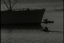
This item is a print of one of seven images created by graphic designer and artist David Hornblow for the City of Vancouver street banner series known as "Waterfront Images". This print depicts the bow of a tugboat and the loaded barge behind it.
Hornblow, David
Part of City of Vancouver fonds
This item is a print of one of seven images created by graphic designer and artist David Hornblow for the City of Vancouver street banner series known as "Waterfront Images". This print depicts a portion of the Canadian Pacific ship Princess Patricia and the central span of the Second Narrows Bridge.
Hornblow, David
Part of City of Vancouver fonds
This item is a print of one of seven images created by graphic designer and artist David Hornblow for the City of Vancouver street banner series known as "Waterfront Images". This print depicts a portion of a Canadian grain hopper car.
Hornblow, David
Part of City of Vancouver fonds
This item is a print of one of seven images created by graphic designer and artist David Hornblow for the City of Vancouver street banner series known as "Waterfront Images". This print depicts a portion of a shipping container and container cranes.
Hornblow, David
Part of City of Vancouver fonds
This item is a print of one of seven images created by graphic designer and artist David Hornblow for the City of Vancouver street banner series known as "Waterfront Images". This print depicts painters working on the side of a ship.
Hornblow, David
Part of City of Vancouver fonds
This item is a print of one of seven images created by graphic designer and artist David Hornblow for the City of Vancouver street banner series known as "Waterfront Images". This print depicts a tugboat pulling log booms. Two large piles of sulphur are shown in the background.
Hornblow, David
Part of City of Vancouver fonds
This item is a print of one of seven images created by graphic designer and artist David Hornblow for the City of Vancouver street banner series known as "Waterfront Images". This print depicts a portion of a passenger ferry.
Hornblow, David