![Contour plan 220a [Mt. Pleasant]](/uploads/r/null/b/d/bd5c7afeea1a507ba6bc282b904c55c40d1119da939738b1911ba9fd99e6bd21/21ae5b59-321b-4488-bdc6-e782f391b8ea-MAP690_142.jpg)
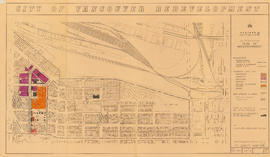
Contour plan 220a [Mt. Pleasant]
- COV-S365-: MAP 690
- Item
- [190-?]
Part of City of Vancouver fonds
Item is a map showing the topography of the area south of False Creek to 15th Avenue in the south and from Glen Drive in the east to Bridge Street (now Cambie Street) in the west.

![[Roadwork on] Kingsway](/uploads/r/null/4/8/484b015b604eabb76763aa147dd9b4c16d9b74baba9ae101ca53f2152953d6ef/fe2a2dce-dc7f-4232-b63b-31963f438069-A16612_142.jpg)

![[View of Squad Wagon car wreck at Broadway and Clark Drive]](/uploads/r/null/8/2/a/82ab696fadf8dde30e6d578856f855345436ca7aa6d9c320e1d3220e07da828c/2f3b92ed-11e0-4136-8f8b-72b3a516e0bf-CVA354-136_142.jpg)
![[View of Squad Wagon car wreck at Broadway and Clark Drive]](/uploads/r/null/a/b/e/abefc9ca8cbf8587fb0caa83d94b0f0b4c64e450ae0ca6207272d36866574fda/3fe5f23d-83c6-4800-bc44-6b43f2633542-CVA354-139_142.jpg)
![[View of Squad Wagon car wreck at Broadway and Clark Drive]](/uploads/r/null/5/3/c/53c679bd6f99951d4c75862b663159ab0baba7e015284b470f926373bd735b38/8216b509-f20a-4bec-8dcf-406c5f69ff32-CVA354-137_142.jpg)


![[2636 Yukon Street, 2 of 2]](/uploads/r/null/c/1/2/c1271a1dbe52bebc929924cba80a1c00e7aad74a9c24c7a174f4bf33381a8d6e/ee204789-a9d0-4904-8c18-95500d739887-CVA1095-00271_142.jpg)
![[Lovers II sculpture, Vancouver City Hall]](/uploads/r/null/0/e/4/0e4e722c677a0ee8051d54c70a5e176b25c7ad83091cd7b87c72fb6267db6752/5f0a14df-b5a3-48c0-a28a-4e0f2332aa0d-CVA1095-00282_142.jpg)
![[324-326 West 11th Avenue]](/uploads/r/null/2/f/a/2fa13272d1282afc04ddcd212da226c4b81cf48c1873785e509916e9fbe95a18/207640e1-d3fa-49e7-b94a-b1ad985e2287-CVA1095-01505_142.jpg)
![[154 West 11th Avenue]](/uploads/r/null/4/7/7/47775d0d1e1fbf9190bb39a0a4c59d3ff0cb5133a474ceefd94a0d2a9a0864b9/7def0f61-f338-4464-8778-2de574fdfaf0-CVA1095-01510_142.jpg)
![[31 West 11th Avenue]](/uploads/r/null/d/1/4/d1464f9253a99d5bf64acdddd7d31292d866a0962168e3710807c382abfc5589/6f7ec6d4-8cf4-41c2-a565-0961dd5642d2-CVA1095-01516_142.jpg)
![[42 West 11th Avenue]](/uploads/r/null/0/0/6/00657a1ec8b7c4b5545f5df4684039743091154aba61c1ff2145fdbb3b28f113/f9a0f52e-c253-4a31-a837-271acdd69dec-CVA1095-01523_142.jpg)
![[37 West 11th Avenue]](/uploads/r/null/f/0/f/f0f9d9cb3de7f456695d9238a60b3e6452e05e3980f4eb5df645aa04fb89ea7b/a6758042-bd80-498d-a4ac-4c00ed8ff3c9-CVA1095-01524_142.jpg)
![[52 West 11th Avenue]](/uploads/r/null/e/8/b/e8b9d4b1679a77aee873840f3c495caeef2bbcfc6cb8e549c5d20b347689375a/a9f364e9-a652-4560-9ae9-897cd81d10c0-CVA1095-01525_142.jpg)
![[148 West 11th Avenue]](/uploads/r/null/4/b/0/4b0bce718642f704d93b99f515c22a0fbd5e9d4e34813397caa971143d2a2072/ae679804-b9b4-48d9-8780-ae78fde1932a-CVA1095-01526_142.jpg)
![[139 West 11th Avenue]](/uploads/r/null/0/e/3/0e368936ed65ff057909333b6cd3e7c779c32bcb0a60f888cc22f616114801db/4c9d62cd-14c4-41bc-bc57-7704a7b91b2d-CVA1095-01529_142.jpg)
![[356 West 11th Avenue, 1 of 2]](/uploads/r/null/5/2/5/525e8af29281dadd7eb2e1e40a3fa5db01bce5a75ae788485c98bc7ec7ea5976/10bc5c8e-236b-4e2f-b97b-7005fb0a514b-CVA1095-01532_142.jpg)
![[54-56 West 10th Avenue]](/uploads/r/null/b/1/b/b1b9095563daeb76dcd8e1cf2a340512e1b102c7622cd53a1b4607a288096778/ba1a0d4d-19f7-423c-9992-b01c22c58a4d-CVA1095-01543_142.jpg)
![[233 East 11th Avenue]](/uploads/r/null/0/7/5/0754e32c1764be39f8c116da18d427683306c35447fb623a53e4efcfebf59624/6b06d205-9f00-4be1-9dd3-a88543992e8c-CVA1095-01553_142.jpg)
![[470 East 10th Avenue]](/uploads/r/null/f/a/6/fa675f1e3a038d9452dc4b932288f04fdf6ed69cfd72ee2ef8a0bba02ff0543d/9cfc345f-0e2e-4e85-8845-5d3658fa49bd-CVA1095-01556_142.jpg)
![[466 East 10th Avenue]](/uploads/r/null/2/6/4/26443395c9b11115ba2c06ff71521755c8d459bb652bcd1d73eb56c17b4692b8/b02110a0-9a96-4461-9e3d-7aa8f461e586-CVA1095-01557_142.jpg)
![[458 East 10th Avenue]](/uploads/r/null/6/6/a/66a68bb011253f21025d00ef55f8309c6ebff0e9060798e450c5b405c3c39225/c37cf77a-d8b1-42a4-aba5-5d2428f878e2-CVA1095-01559_142.jpg)
![[2525 Quebec Street - Evangelistic Tabernacle]](/uploads/r/null/b/4/f/b4f40d7c97ddff93ac52e71bf19e679855e9cd1330aa05898c713a6cd654aeb0/3ccd7fb2-c45f-47c1-9143-44ea08abd39d-CVA1095-01563_142.jpg)
![[20 East 10th Avenue]](/uploads/r/null/f/6/6/f665ca15e3a277684dce1c732ef29dbbfedefcb230bdc7c686d4a4b683adc016/732afe49-5abc-4aa4-adf9-5fab63dc5227-CVA1095-01565_142.jpg)
![[148 West 10th Avenue]](/uploads/r/null/7/4/d/74d67f6e0aaac1b435fe3245645ba324aa1d6c8399376382eaf451f9ef29c595/e279b7f4-b69a-4292-b61c-b2ec9f742f40-CVA1095-01568_142.jpg)
![[130 West 10th Avenue]](/uploads/r/null/e/c/5/ec57c1978e9e77bd967f0c189898228b7a4d97bd8d766b1c920e5d26d97c7738/fa3b8d92-4312-48ff-b576-1293a8e68553-CVA1095-01575_142.jpg)
![[345 West 11th Avenue]](/uploads/r/null/3/c/1/3c19bc7b89e35ad07f821512855121be3fe4f2b3ecd80f6687b2cf17d4c3286d/6512135d-8d41-4aea-a402-1a01a6cd7aa3-CVA1095-01501_142.jpg)
![[325 West 11th Avenue]](/uploads/r/null/c/5/a/c5af142b0a35eac59f4f7c1de40b5550a9b88ca7d06165f5631a17a0bd4ad0b7/350859d1-2b08-48b7-8130-b12d1d70ba12-CVA1095-01504_142.jpg)
![[231 West 11th Avenue]](/uploads/r/null/1/0/2/102509385f26c494aae1f00b9d352f629d1e97dd1bde8500b317f77cdda968c0/63113020-c245-490d-95e1-3dc3fb3c4cfd-CVA1095-01508_142.jpg)
![[24 West 11th Avenue]](/uploads/r/null/2/7/8/278439b0a1789db91b83d911d5ff5baa716e1124f3f8e7d6ea462f8ad0dc6737/6f94133c-544f-4833-9c5c-f23b463845fa-CVA1095-01517_142.jpg)
![[46 West 11th Avenue]](/uploads/r/null/6/f/a/6facb49e7ccd63bbaf3069a364d7e23038a63e1c715a392b6d7810b9c9ed05d8/1401428b-62ec-4433-b079-9034a21c5180-CVA1095-01521_142.jpg)
![[43 West 11th Avenue]](/uploads/r/null/8/f/5/8f5bb6e0a7843e1f5af099f36c22fc1cec4194a282083b69190904a43dc12460/871c706d-1314-4424-9fd2-ca6f8ea2a0d8-CVA1095-01522_142.jpg)
![[121 West 11th Avenue]](/uploads/r/null/b/b/f/bbf11a22f782b376e3ed0c631f677b404783edfaaa9fa743b1a0db3507766e8f/bb329d52-7cbe-4dd4-ac2a-badff15b235b-CVA1095-01534_142.jpg)
![[28-30 West 10th Avenue]](/uploads/r/null/0/1/9/01959765c61da067476fdf490c4333c566829af046edd55b39c1edf8d1ea9a47/0c1ce73c-2480-4587-94fb-efc79335e190-CVA1095-01539_142.jpg)