- COV-S639-1-F72-: CVA 790-2351
- Item
- [1985?]
Part of City of Vancouver fonds
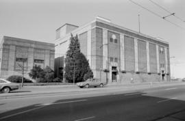
Item is a photograph of the Murrin Substation.
Part of City of Vancouver fonds
Item is a photograph of the Murrin Substation.

Part of City of Vancouver fonds
![[Firefighters and motorized equipment in front of Firehall No. 2, 754 Seymour Street]](/uploads/r/null/1/a/2/1a2f1373f1d648856294c4009aca38f93d121927679c379a3ab4dd4db0fd8128/e7169b57-02b8-4cc5-a5d8-122e1c212954-CVA354-043_142.jpg)
[Firefighters and motorized equipment in front of Firehall No. 2, 754 Seymour Street]
Part of City of Vancouver fonds
Part of City of Vancouver fonds

Hydro electric surveys. Plan showing location of water powers investigated by City of Vancouver
Part of City of Vancouver fonds
Item is a map which shows the locations and the dates of use of "gauging stations established" and "city gauging stations still in use" in the area of south-western British Columbia where the City of Vancouver conducted hydro-electric surveys up to 1923.

Hydro electric surveys. Plan showing location of water powers investigated by City of Vancouver
Part of City of Vancouver fonds
Item is a map which functions as a visual index to the locations of various hydro electric surveys carried out by the City of Vancouver along the following rivers: Squamish River, Cheakamus River, Green River, Lillooet River, Eagle River, Indian River, Pitt River, Chehalis River, Harrison River, Chilliwack River, the Fraser and Thompson Rivers, and Bridge River. The map lists the names of the surveyors responsible and the areas covered by each survey. Annotations include the locations and the dates of use of "gauging stations established" and "city gauging stations still in use."

Part of City of Vancouver fonds
Item is a map which depicts two alternative routes for running power pole lines from a power house on the Cheakamus River to Burrard Inlet: along the Cheakamus River, with an alternative route along Seymour Creek.
![Hastings Street, South Granville, Chinatown [Power lines]](/uploads/r/null/1/9/f/19fb643ced9b72927d05a29a149e92e02b9e267a85eb3fd3a7c67a451631c9d1/34eac91e-9ab5-4cb9-9394-fd71b5dd4834-CVA1095-08723_142.jpg)
Hastings Street, South Granville, Chinatown [Power lines]
Part of City of Vancouver fonds

Cheakamus power survey : copy of portion of plan no. 11 accompanying report by E.A. Cleveland
Part of City of Vancouver fonds
Map is a topographical plan showing elevations and the location of power houses, dams, pipelines, tunnels and railways as well as mountains, glaciers, creeks and lakes in the Garibaldi Lake area. The map shows the area approximately between the Cheakamus River in the west and Pitt River in the east, and between Green Lake in the north and Rampart Lake in the south.
The map is a tracing of a portion of one of the maps created by E.A. Cleveland in 1931 and was included in the appendix to his report to the City of Vancouver on the hydro-electric capacity of the Cheakamus River system (the atlas of maps accompanying the Cleveland report is MAP 939). Sheet 11 of that atlas was a copy of the map Topographical map of Garibaldi Park, published by the British Columbia Department of Lands in 1928, a copy of which had been used as a base map to note elements of the Cheakamus River hydro-electric survey.

Part of City of Vancouver fonds
Item is a photograph showing uniformed fire fighters riding in horse-drawn fire wagons; Parnell McCarville (right center) came on duty July 29, 1907, others unidentified.
![[View of fire at G.H. Cottrell Warehouse, 139 Water Street]](/uploads/r/null/d/4/2/d42e9cc6d0ed113b820738761abee8e002b3343ece277b2d2aa63d56af341039/38d982ad-3791-47df-aa20-a24e3dff0244-CVA354-018_142.jpg)
[View of fire at G.H. Cottrell Warehouse, 139 Water Street]
Part of City of Vancouver fonds
Item is a photograph showing fire fighters climbing a ladder at building with hoses and engines below and spectators watching from below and from across the street at a rooming house.

Part of City of Vancouver fonds
Item is a photograph showing a group portrait of men and women. Inscription on print reads: "Visiting fire chiefs of convention held in Victoria, B.C., Gorham Rubber Co. Pacific Coast Agents; compliments Baker Fire Department, Baker, Oregon"
Part of City of Vancouver fonds

Part of City of Vancouver fonds
![[Chief Turner and Captain Munro of Point Grey Fire Department aboard Fire Chief's automobile]](/uploads/r/null/3/e/5/3e56e5f7a117044aa405bb2770771b159eaa81c0098a98a3b9a0bc8b4ce9b545/a568a13d-a0a2-4bb7-b487-d0ba9f4a08d3-CVA354-047_142.jpg)
[Chief Turner and Captain Munro of Point Grey Fire Department aboard Fire Chief's automobile]
Part of City of Vancouver fonds
Item is a photograph showing Turner in the passenger seat and Munro at the wheel.
![Hastings Street, South Granville, Chinatown [Street light and power lines]](/uploads/r/null/5/5/b/55b7bcff2db2fd3e5804f7e950367b10abe53950da9d3d4677c15d185f212732/9c92271d-5270-4e90-b1f9-c4bb96a359e6-CVA1095-08733_142.jpg)
Hastings Street, South Granville, Chinatown [Street light and power lines]
Part of City of Vancouver fonds