Showing 13116 results

Archival description
City of Vancouver fonds Vancouver (B.C.) Item With digital objects
Print preview View:

Drainage and electrical wiring plan, for public convenience, Hamilton Street, Vancouver B.C.

Item is an architectural drawing showing plans for public washrooms on Hamilton Street, between Pender Street and Hastings Street in downtown Vancouver, B.C. The drawing includes a floor plan, a longitudinal section, a plan of the sidewalk top, and a location plan. Drain, vent pipes, and electric wiring are shown.

Vancouver (B.C.). Engineer's Office

Contour plan of a portion of the City of Vancouver

Item is a map of the area from Chilco Street to Raymur Avenue and Coal Harbour/Vancouver Harbour to False Creek showing topographic contour lines, streets, block numbers (in Roman numerals), sewers, manholes, and elevations at various points along streets.

Sheet 20 : Granville Street to Ontario Street and Robson Street to Sixth Avenue

Item is a section showing Granville Street to Ontario Street and Robson Street to Sixth Avenue. Includes streets, roads, blocks, lots, legal descriptions, businesses, crown leases, city leases, the Granville Street and Connaught (Cambie) Bridges, and the False Creek yards. Map is hand coloured to show tax sale property for sale, property with no water, street widening and drainage, replotting, reserved land for schools, reserved land for parks, sundry land, capital assets not including schools and parks, schools, and parks, as applicable.

Vancouver (B.C.). Office of the City Engineer

Sheet 15 : Ash Street to St. George Street and Fifty-eighth Avenue to Marine Drive

Item is a section showing the area from Ash Street to St. George Street and Fifty-eighth Avenue to Marine Drive.Includes streets, roads, blocks, lots, legal descriptions, parks and railway lines. Map is hand coloured to show tax sale property for sale, property with no water, street widening and drainage, replotting, reserved land for schools, reserved land for parks, sundry land, capital assets not including schools and parks, schools, and parks, as applicable. A note in ink at the top of the map indicates that "Brown-green refers to the Crippled Childrens Hospital Reserve."

Vancouver (B.C.). Office of the City Engineer

Sheet 16 : St. George Street to Argyle Street and Fifty-eighth Avenue to Fraser River

Item is a section showing the area from St. George Street to Argyle Street and Fifty-eighth Avenue to the Fraser River. Includes streets, roads, blocks, lots, legal descriptions, railway lines, parks and schools. Map is hand coloured to show tax sale property for sale, property with no water, street widening and drainage, replotting, reserved land for schools, reserved land for parks, sundry land, capital assets not including schools and parks, schools, and parks, as applicable.

Vancouver (B.C.). Office of the City Engineer

Sheet 2 : Slocan Street to Boundary Road and Charles Street to Triumph Street

Item is a section showing the area from Slocan Street to Boundary Road and Charles Street to Triumph Street. Includes streets, roads, blocks, lots, legal descriptions, parks, schools, and retirement homes. Section is annotated in colour to show tax sale property for sale, property with no water, street widening and drainage, replotting, reserved land for schools, reserved land for parks, sundry land, capital assets not including schools and parks, schools, and parks, as applicable.

Vancouver (B.C.). Office of the City Engineer

Sheet 1 : Slocan Street to Boundary Road and Triumph Street to Burrard Inlet

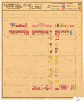
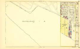
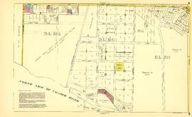
Item is a section showing the area bound by Slocan Street, Boundary Road, Triumph Street and the waterfront. Includes streets, roads, railways, blocks, lots, legal descriptions, quit claims, leases, parks and businesses along the waterfront. Section is annotated in colour to show tax sale property for sale, property with no water, street widening and drainage, replotting, reserved land for schools, reserved land for parks, sundry land, capital assets not including schools and parks, schools, and parks, as applicable.

Vancouver (B.C.). Office of the City Engineer

Sheet 23 : Stanley Park to Granville Street and Robson Street to False Creek

Item is a section showing the area from Stanley Park to Granville Street and Robson Street to False Creek. Includes streets, roads and railways; blocks, lots and legal descriptions; as well as parks, schools, hospitals and churches. Shows the Burrard Bridge and C.P.R. property. Map is hand coloured to show tax sale property for sale, property with no water, street widening and drainage, replotting, reserved land for schools, reserved land for parks, sundry land, capital assets not including schools and parks, schools, and parks, as applicable.

Vancouver (B.C.). Office of the City Engineer

Sheet A : University Endowment Lands to Imperial Street and waterfront to Fifth Avenue

Item is a section showing the area from the University Endowment Lands to Imperial Street and waterfront to Fifth Avenue. Includes streets, roads and sewers; blocks, lots and legal descriptions; and parks. Map is annotated to show tax sale property for sale, property with no water, street widening and drainage, replotting, reserved land for schools, reserved land for parks, sundry land, capital assets not including schools and parks, schools, and parks, as applicable.

Vancouver (B.C.). Office of the City Engineer

Sheet F : Wallace Street to Trafalgar Street and Sixteenth Avenue to Twenty-seventh Avenue

Item is a section showing the area from Wallace Street to Trafalgar Street and Sixteenth Avenue to Twenty-seventh Avenue. Includes streets, roads, blocks, lots, legal descriptions, parks and schools. Section is annotated to show tax sale property for sale, property with no water, street widening and drainage, replotting, reserved land for schools, reserved land for parks, sundry land, capital assets not including schools and parks, schools, and parks, as applicable.

Vancouver (B.C.). Office of the City Engineer

Sheet H : Alexandra Street to Cambie Street and Fifteenth Avenue to Twenty-seventh Avenue

Item is a section showing the area from Alexandra Street to Cambie Street and Fifteenth Avenue to Twenty-seventh Avenue. Includes streets, roads, blocks, lots, legal descriptions, parks, hospitals and schools. Section is annotated to show tax sale property for sale, property with no water, street widening and drainage, replotting, reserved land for schools, reserved land for parks, sundry land, capital assets not including schools and parks, schools, and parks, as applicable.

Vancouver (B.C.). Office of the City Engineer

Sheet J : University Endowment Lands to Wallace Street and Twenty-ninth Avenue to Thirty-eighth Avenue

Item is a section showing the area from the University Endowment Lands to Wallace Street and Twenty-ninth Avenue to Thirty-eighth Avenue. Includes streets, roads and sewers; blocks, lots and legal descriptions; and parks and schools. Section is annotated to show tax sale property for sale, property with no water, street widening and drainage, replotting, reserved land for schools, reserved land for parks, sundry land, capital assets not including schools and parks, schools, and parks, as applicable.

Vancouver (B.C.). Office of the City Engineer

Sheet N : Musqueam Reserve to Wallace Street and Thirty-eighth Avenue to Forty-ninth Avenue

Item is a section showing the area from the Musqueam Reserve to Wallace Street and Thirty-eighth Avenue to Forty-ninth Avenue. Includes streets, roads and sewers; blocks, lots and legal descriptions; and parks and schools. Map is hand coloured to show tax sale property for sale, property with no water, street widening and drainage, replotting, reserved land for schools, reserved land for parks, sundry land, capital assets not including schools and parks, schools, and parks, as applicable.

Vancouver (B.C.). Office of the City Engineer

Sheet S : Musqueam Reserve to Macdonald Street and Forty-ninth Avenue to Fraser River

Item is a section showing the area from Musqueam Reserve to Macdonald Street and Forty-ninth Avenue to the Fraser River. Includes streets and roads; blocks, lots and legal descriptions; and parks and golf courses. Map is hand coloured to show tax sale property for sale, property with no water, street widening and drainage, replotting, reserved land for schools, reserved land for parks, sundry land, capital assets not including schools and parks, schools, and parks, as applicable.

Vancouver (B.C.). Office of the City Engineer

Sheet W : Fraser River to French Street and Fifty-ninth Avenue to Seventy-first Avenue

Item is a section showing the area from Fraser River to French Street and Fifty-ninth Avenue to Seventy-first Avenue. Includes streets and roads; blocks, lots and legal descriptions; and parks and golf courses. Map is hand coloured to show tax sale property for sale, property with no water, street widening and drainage, replotting, reserved land for schools, reserved land for parks, sundry land, capital assets not including schools and parks, schools, and parks, as applicable.

Vancouver (B.C.). Office of the City Engineer

Sheet 4 : Prince Edward Street to Bruce Street and King Edward Avenue to Thirty-sixth Avenue

Item is a section showing the area from Prince Edward Street to Bruce Street and King Edward Avenue to Thirty-sixth Avenue. Map shows streets, roads, blocks, lots and legal descriptions, and the locations of parks, schools and Mountainview Cemetery. Map is hand coloured to show tax sale property for sale, property with no water, street widening and drainage, replotting, reserved land for schools, reserved land for parks, sundry land, capital assets not including schools and parks, schools, and parks, as applicable.

Vancouver (B.C.). Office of the City Engineer

Sheet 10 : Earles Street to Boundary Road and Fortieth Avenue to Fiftieth Avenue

Item is a section showing the area from Carlton Street to Boundary Road and Fortieth Avenue to Fiftieth Avenue. Includes streets, roads, blocks, lots, legal descriptions, parks and schools. Map is hand coloured to show tax sale property for sale, property with no water, street widening and drainage, replotting, reserved land for schools, reserved land for parks, sundry land, capital assets not including schools and parks, schools, and parks, as applicable.

Vancouver (B.C.). Office of the City Engineer

Project 2 area "h" and part of "b" : identification plan

Item is a map created to show the boundaries of redevelopment areas "b" and "h" in Project 2 and Project 2 clearance areas 8 & 9. The map also shows City-owned property, Adjacent lots in same ownership, as well as property, streets and lanes be acquired for the project. The portion of the City depicted in the map is the area between Main Street and Clark Drive and between Evans Avenue and 10th Avenue (D.L.200, D.L. 264A, D.L. 301, and D.L. 2037).

Complete pedestrian mall : all traffic taken off : street closed

Item is consists of an architectural drawing showing three stages of development of a proposed pedestrian mall on Granville Street between Georgia Street and Dunsmuir Street. The pedestrian mall includes a sculpture fountain, sidewalk terraces (cafés), children's play area with merry-go-round, fish pool and fountain pool.

Commercial study (April 1961) : Fourth Avenue (Arbutus to Balsam) -- Yew Street (4th Avenue to Broadway) : land use

Map is a plan of the area bounded by Balsam Street, 3rd Avenue, Arbutus Street and Broadway, showing streets, blocks and some buildings. Structures are indicated on the plan for Yew Street between Fourth Avenue and Broadway and for Fourth Avenue, between Balsam and Arbutus Street. Structures are hand coloured to indicate land use, such as single family dwellings or business offices. Plan is labelled " K, 1961 April, 3941B, small."

Urban renewal scheme 3 : Strathcona I & portion of Highway 6 : condition of non-residential buildings

Map is a plan showing streets, blocks, lots and structures in the area just west of Main Street to just east of Glen Drive and from Burrard Inlet in the north to Prior Street in the south. The map is hand coloured to show the condition of non-residential buildings from very good to very poor, and areas that are mixed residential and non-residential, in the area bounded by Main Street, Hastings Street, Glen Drive and Prior Street, based upon a 1957 field survey. Also included are the names of businesses along the waterfront.

Urban renewal scheme 3 : Strathcona I : existing land use

Map is a plan showing streets, blocks and lots in the area bounded by Columbia Street, Burrard Inlet, Glen Drive and Atlantic Street. The map is hand coloured to show the different types of land use in the area between Columbia Street and Glen Drive and Atlantic Street and Hastings Street. Red tape is used to identify the boundaries of the Strathcona sub-area and Project 1 and Project 2 areas are also indicated.

Robson Street sidewalk scene

Item part is a photograph of a street and sidewalk scene looking southeast down Robson Street from between Thurlow Street and Burrard Street. Signage and some storefronts are visible for many businesses, identified are: Galloways specialty foods (1084 Robson Street), Feinschmecker Delicatessen (1080 Robson Street), Schnitzel House (1060 Robson Street), Danish Tea Room Ltd. (1068 Robson Street), Continental Gem House (1056 Robson Street), and the European News & Import House (1044 Robson Street). The Toronto Dominion Bank tower (700 W. Georgia Street) and the Eaton's Building (701 Granville Street) are visible in the background on the left.

Robson Street sidewalk scene

Item part is a photograph of a street and sidewalk scene looking southeast down Robson Street from between Thurlow Street and Burrard Street. Signage and some storefronts are visible for many businesses, identified are: Murchie's Tea and Coffee Ltd. (1008 Robson Street), O'Brian Optician and Jewellers (1016 Robson Street), and Happy Feet Shoe and Repair (1028 Robson Street). The Eaton's Building (701 Granville Street) is visible in the background on the left.

Results 1 to 50 of 13116