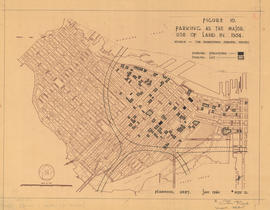
Figure 10 : parking as the major use of land in 1954
- COV-S445-3---: LEG37.16
- Item
- 1960
Part of City of Vancouver fonds
Map is a plan of downtown Vancouver showing parking structures and parking lots in the area between Jervis Street and Main Street and Burrard Inlet and Nelson Street. The source of the map is indicated as 'The Downtown Parking Report'. Note written in the bottom right corner of the map reads "B 1960 Jan., Traffic Plans, small folder."


![[View of] Downtown from Cambie Bridge](/uploads/r/null/9/5/9569782086f72e1216c2b4c9677babe70ef361e9008444790951403f3fbd32d3/af222087-669e-456f-980d-947447a9da81-A58781_142.jpg)

![[Northwest view of downtown from the] Granville Bridge](/uploads/r/null/e/4/e49940debc1893b6a85422a93a903e5985efe0bcf3da3e4e2f8605f5bb0afae4/34b8ded9-24c9-4ce1-97a2-cd5ef3a1adad-A58886_142.jpg)
![[Exterior view of the] Rogers Building at 470 Granville [Street]](/uploads/r/null/4/6/46adbf6de86563ba2801897f647aeec25ac060dc7aaec2f768c50b1ef535ff0c/96b3499c-9b58-48ef-bd7b-1103447affaa-A58791_142.jpg)
![[House at] 1380 Hornby](/uploads/r/null/5/0/505cdc7018e6eb6b1ee72685c209be8f01995287ed65023a23fdfca86b61ccfa/9729f1f3-8e00-453c-9a51-05c1ab1122df-A58792_142.jpg)
![[View of the Toronto Dominion Tower, 700 West Georgia Street, at] Granville Street and Georgia St...](/uploads/r/null/0/d/0d5825a63a8302a28bbccc347e37195fc3dc9d74fd1c94b3a6653b2611fa6b23/f267eb33-aa57-4280-8a8a-2825c8a3f00d-A58793_142.jpg)
![[View of the Granville Square Building at 200 Granville Street; part of] Project 200](/uploads/r/null/4/a/4aeb781e42814d7b0cd71b4b9e286259a575676b797a819022d41b079926dc35/073b4606-e3b2-4704-a004-c225f770e6c5-A58794_142.jpg)
![[Buildings and businesses in the] 300 [block] W[est] Pender [Street]](/uploads/r/null/7/1/71d4bcefaee605751b5a94d8cc2805ac8a3eb5f8e946d37583310f5b26eeaa54/3c8d1476-712a-4e9a-aad7-7e5844412875-A58796_142.jpg)
![[View of the] MacMillan Bloedel [building at 1075 West Georgia Street]](/uploads/r/null/a/4/a4fe559bc9d179e8b2312a9fd08a576f5d8034e005e6d08c7afa90fe42590052/e8ba070e-5dac-4c7c-b48b-1e37800220e9-A58797_142.jpg)
![[View of the Bentall Centre and the Melville Building under construction] on Burrard Street](/uploads/r/null/0/9/09e94079022f3a3fc971725a4ca0252f84c6f2e991049904497f690569f069ea/74593a6b-7dbc-4cd9-9b26-92e006da903e-A58798_142.jpg)
![[Side view of the Marine Building, 355 Burrard Street]](/uploads/r/null/b/d/bde3918ab2726a854d759bf218dbb96fa70c14797a24e9999f704c6dad70355c/61cd57a0-6d17-4fe8-99c6-2600542002ca-A58799_142.jpg)
![[View of downtown Vancouver at night from North Vancouver]](/uploads/r/null/2/e/2ebbab19f6079ff3f117ab4a05569a9eff63ee5e56d32eb353f6c132e0ffddc6/7ac150be-2bca-4274-b222-03a017222874-A58782_142.jpg)
![[Northwest facing cityscape view of Mount Pleasant]](/uploads/r/null/1/a/1a8e45a404893b76fbce13ae65f1d98bf633b22ee02126f11bda277730967c14/ff1fc560-a87d-486b-8fc6-c2ddbed44d41-A59084_142.jpg)
![[View of the] Royal Bank [at 404 West Hastings Street]](/uploads/r/null/a/a/aa9ea08c785620e90088beea81218b8aaec6fadeb94187aefc1ae6a0c8df1b90/302d6abf-6979-4791-b31d-f1f016966457-A58802_142.jpg)
![[Northwest facing cityscape view of Mount Pleasant and Downtown]](/uploads/r/null/d/a/da130ea231fd00e2f264f71a2d8411bb91248bd27e938e1f525d72d87c62a7fd/3dc3cbeb-51c8-416f-af5c-838becd2699d-A59085_142.jpg)
![[Northwest facing cityscape view of Mount Pleasant, False Creek and Downtown]](/uploads/r/null/a/8/a87cf5cf19ae87f08c8a84b680215623baab879c47c16682d33de88e63056e1a/0fe4358c-f755-4cb7-ae82-212af70d5d7b-A59086_142.jpg)
![[View of Untitled (Silver Bird) sculpture at the corner of Granville and Georgia]](/uploads/r/null/e/2/e2717f710573afbe376dd2a64c824bfdf778bb02a404c6004c308222e26d30a7/3089fe50-191e-48a7-831e-b9e854ec4514-A58812_142.jpg)
![Pacific Centre [construction] progress](/uploads/r/null/8/3/83f5b4449d75a61f858bd0b7a835daf05aa5ea6d4a2d89937a7a98f9f450ba1a/ac4e05fe-96a0-48e0-84be-0b181e173ff5-A58816_142.jpg)
![[Vancouver Resource Building on] 535 Homer [Street]](/uploads/r/null/6/6/66e9d6bba7e61a8b81224c5fa744a1d218217bb7407ce868e3bd8cb28e611913/97f03c44-2c53-49a7-8069-dedaba9b4617-A58819_142.jpg)
![[View of downtown buildings along Burrard Street looking North]](/uploads/r/null/5/a/5a82ccfb1d2392a1188543bd83994537c1d8a16d3a41d5e1fb527620a844f302/7232413b-1b2f-4ee6-81a9-f373e7d2dc82-A58784_142.jpg)
![[View of the Richmond Apartments and the rear of the Hotel Vancouver]](/uploads/r/null/a/0/a066734feb6aafd55603fe1ef846e547c8ee0604b29c8b552e65eff8980e4632/1974229c-d760-4715-9aec-832ef011392f-A58820_142.jpg)
![[View across English Bay to Downtown and the West End]](/uploads/r/null/f/1/f13eba0b35da4974fd6bbaf2a072d0a37a58c663cc4cb553c95e5c71df44a2eb/2f6e8ed0-aeb1-4ad8-964e-b14fc7469074-A59307_142.jpg)
![[View of buildings along] Burrard [Street from] Pender [Street]](/uploads/r/null/1/f/1f9e89170335d25cb7a85a7bf23afbbfb37c30dece57e464d0ad201c3103e635/8842ad98-717f-450e-b171-9a536b747994-A58825_142.jpg)
![[View of buildings from] Hastings St[reet] at Granville [Street]](/uploads/r/null/c/2/c27a7826be7b3190205fc70c42e70a63dc7135c8703a763b83348842015f18bc/5d3a5c8f-e032-4b03-ba6d-129b36323885-A58826_142.jpg)
![[View of buildings along] Georgia [Street] at Howe [Street]](/uploads/r/null/2/5/25925eb9deca768d861fb66288afbc419d9577d2ceffe839e602741c9f1fe045/7667223a-418c-4c33-aa55-330ed473d8a7-A58827_142.jpg)
![[View of Downtown from the Vancouver Iron and Engineering Works Ltd. at 1155 West 6th Avenue]](/uploads/r/null/3/1/318625c5a9ad983f92e59fa31c7055a196f7feb179dd8dffcedae145a36c5cc5/52732964-6835-4d57-9a91-a7816c96cea0-A59350_142.jpg)
![Hastings St[reet] at Beatty [Street], facade of old building well maintained](/uploads/r/null/9/0/909dd9da929141a05e9f7543618e58842177539535fce199b6d2d49e76486d33/c93cc8b3-becd-4aae-bd27-e01a64f94115-A58829_142.jpg)
![Looking at rear of [buildings] facing Beatty St[reet] (between Georgia and Robson) from West End ...](/uploads/r/null/d/a/dad7cd9e32f1d655acdce3f818d8df66014dc7e0ca50c6f799179689329fc136/00ebbe3c-a323-43b8-9453-0a03ffd6a54a-A58785_142.jpg)
![[View of the 800 block Granville Street, Theatre Row]](/uploads/r/null/4/2/4262db33137944d1c0ab7530ceadd9e59536311bdbc4bd477388384b9dbf1cba/f89e507e-cfe8-4359-be0f-248beb4bec4e-A58830_142.jpg)
![[View of the 800 block Granville Street, Theatre Row]](/uploads/r/null/4/6/4604647a4ac0dd31a1ecf18dbd99c9bbead3748205fc52a9b5f50950b106fe33/1aad9bb5-35aa-42cf-a86c-21b2d3de8ee0-A58831_142.jpg)
![[View of the 900 block Granville Street, Theatre Row]](/uploads/r/null/c/c/cca048920f54e5c04d2dc9f62010ee54d77dd13b9b854f4fec4f45cf9f53d3b0/604d0321-4961-466a-82b6-0683c168989e-A58832_142.jpg)
![[View of the 900 block Granville Street, Theatre Row]](/uploads/r/null/e/0/e08bb0eecba9ba31c98ed5a2418737d0960a2515049dc8e7b0c7bb55e02672fe/564395ca-19e8-4a82-a1bf-3a174b9edf56-A58833_142.jpg)
![[View of the 800 block Granville Street, Theatre Row]](/uploads/r/null/b/d/bd595f15d5f2b92533fdae45764e856587dbfdd2f25c9ff0fdb41705f1bfe04b/45a1f896-80a2-4bbb-b617-75ca98a6bd1a-A58834_142.jpg)
![[View of Granville Street, Theatre Row]](/uploads/r/null/b/f/bf4df1d3fcb1efd9184b28efb614d95a73c1fea6a4ee23b741b4fa32a125e598/76e970c2-009b-4585-a375-dcc2a4e3f32a-A58835_142.jpg)
![[View of Granville Street, Theatre Row]](/uploads/r/null/e/f/efa1686e75b5d583d5911e5fd364e4f76745141a2a31e972eaa606b99f3b9559/70fc52c8-d7ca-4749-961e-790154f57fb3-A58837_142.jpg)
![[View of the Holy Rosary Cathedral at 646 Richards Street]](/uploads/r/null/b/b/bb3649b12260e23f3aac9bbb69edc981bc5554eb8ad559e1ef31d74181c7fd80/342e5771-2d64-4ba5-909d-7a30990e555d-A58838_142.jpg)
![[Cityscape view of downtown looking North-West]](/uploads/r/null/b/9/b95782e50593bd4e9637c37355cf72f23fab74f503462817d0f2cf4472f787c8/326767f9-9f75-4af1-aef4-d2c325cfdd3e-A58786_142.jpg)
![[View of Downtown buildings with superimposed rendering]](/uploads/r/null/c/c/cca2352dc159cc4cb7055563422016694731dfa871936f53a904739c473ae060/d0617a28-fd78-4e23-8af7-3784d460c431-A58787_142.jpg)
![[Aerial view of Downtown Vancouver and False Creek]](/uploads/r/null/0/8/087fe83a1eefc33a2d459ff334b7d0e0a538373b4cd81c1bdcfd7fe9e133d279/a723e464-4fab-4bb6-bee2-27d542364fb0-A58788_142.jpg)
![Van[couver] Harbour - CP Ferry](/uploads/r/null/b/c/bc94d522ca5f2c177aa931b5bc3ce8d0b466830863e4157cf31b32c6a17ab423/29b8aaf7-65f2-4667-9473-5e38173095ae-A59829_142.jpg)