![[Aerial view of Stanley Park from downtown, 2 of 2]](/uploads/r/null/8/d/f/8dfcdae0f34fc74635d4083942eb671c0ef2a5ac52c683008bafec1a8ee3e3ec/c8facdb8-84fd-459b-935a-f90e79b7a972-CVA1095-07043_142.jpg)
[Aerial view of Stanley Park from downtown, 2 of 2]
- COV-S644-: CVA 1095-07043
- Item
- June 1974
Part of City of Vancouver fonds
31 results with digital objects Show results with digital objects
[Aerial view of Stanley Park from downtown, 2 of 2]
Part of City of Vancouver fonds
![[Aerial view of Stanley Park from downtown, 1 of 2]](/uploads/r/null/e/a/2/ea2fa7aeab8d090954336d4db69c725ba8abe57666d3be52009dbd001144c31e/c53aa37e-5123-4247-bfcf-31b31651977f-CVA1095-07042_142.jpg)
[Aerial view of Stanley Park from downtown, 1 of 2]
Part of City of Vancouver fonds
![[HMS Egeria plaque]](/uploads/r/null/d/2/0/d2056c0dae8264076fbe68bb66478cab784b11b94440906aa1f6636b16478ead/52f19f3e-b5a8-4e1f-b499-7680c1db4e0d-CVA1095-00038_142.jpg)
Part of City of Vancouver fonds
Image is a photograph that depicts a detail of the HMS Egeria plaque. It contains the following inscription: "This concrete slab was set by the Royal engineers in 1865 and was used as a survey point in 1898 by the Royal Navy ship H.M.S. Egeria."
![[View of HMCS Discovery Naval Reserve from Stanley Park]](/uploads/r/null/9/e/9/9e9024d0849a483f5d256508ebaa432abafc2163307e4bbd8b6c5e5536179d0d/60fd1b1d-6f55-4206-b305-83d3fb553521-CVA1095-00037_142.jpg)
[View of HMCS Discovery Naval Reserve from Stanley Park]
Part of City of Vancouver fonds
Image is a photograph that depicts the HMCS Discovery Naval Reserve visible from Stanley Park. The skyline of downtown Vancouver is visible in the background.
![[Totem Poles at Brockton Point, Stanley Park]](/uploads/r/null/8/4/d/84d691118359e83482ae2e4a6495b2f70abeac043c790751ac4bffbb2520b0e8/a8b6664d-35b0-4835-927b-b5214c2cd430-CVA1095-00036_142.jpg)
[Totem Poles at Brockton Point, Stanley Park]
Part of City of Vancouver fonds
![[Totem Poles at Brockton Point, Stanley Park]](/uploads/r/null/a/5/d/a5d441f6893be8641ae281a6e3bbbc19d3bcb73f65f0ba0ab24c3fedf7f7ff35/ba260943-7458-4ed1-b03e-2092a8b1375a-CVA1095-00035_142.jpg)
[Totem Poles at Brockton Point, Stanley Park]
Part of City of Vancouver fonds
![[Rose Garden Cottage, Stanley Park]](/uploads/r/null/b/b/6/bb6bf58fa20dd032ca3b8c193e522a3544b8426d73d2b005a9f1bfbff45589c2/1ebdfa21-a34f-4bd9-af65-649f4699c9bd-CVA1095-00034_142.jpg)
[Rose Garden Cottage, Stanley Park]
Part of City of Vancouver fonds
![[Kiwanis Club Rose Plot, Stanley Park]](/uploads/r/null/a/f/9/af908b453eee8919bb81279067496a762dae178523ce1dd5410cff21b7a32be4/52e40ab0-8502-4319-a228-6af892ec878e-CVA1095-00033_142.jpg)
[Kiwanis Club Rose Plot, Stanley Park]
Part of City of Vancouver fonds
Item is a photograph of a dedication stone with the inscription: "Kiwanis Club Rose Plot First planted in 1920 to demonstrate the possibilities of rose culture in Vancouver. 'The City Beautiful.'"
![[Queen Victoria Monument, Stanley Park]](/uploads/r/null/e/4/1/e41aea6458f156b402ab2baa6bb4d9cb73caf6394c55eb44183fe9b1d38cef8b/4d0a9597-5cbc-4405-a08a-e16362e6a423-CVA1095-00032_142.jpg)
[Queen Victoria Monument, Stanley Park]
Part of City of Vancouver fonds
![[Queen Victoria Monument plaque, Stanley Park]](/uploads/r/null/c/2/4/c24f44e2c023bd2e0cf3c257c9eab55ba5fdb6112003c755c4ee6d81052735e0/8c822362-b817-4da5-9804-14ff17c8841b-CVA1095-00031_142.jpg)
[Queen Victoria Monument plaque, Stanley Park]
Part of City of Vancouver fonds
![[Harding Memorial, Stanley Park]](/uploads/r/null/f/8/2/f82485a469b15179812e50424e6eda085a5f90eb5f8ef9b5e22a37f352de0418/5f425633-13c4-4cf6-a551-0a3ed5870613-CVA1095-00030_142.jpg)
[Harding Memorial, Stanley Park]
Part of City of Vancouver fonds
![[Malkin Bowl, Stanley Park]](/uploads/r/null/f/0/6/f06072f2697f6cb7cd0ddd8979712656de86fcf0823ed21863b9aa442a69b259/56254988-56c2-4e55-9772-d4fb1b228ff1-CVA1095-00029_142.jpg)
Part of City of Vancouver fonds
![[Stanley Park Pavilion]](/uploads/r/null/a/f/8/af899bc303190c483559c87800c71d56ded7f51cebf54bc52d96b894709797bf/a023bf4e-8bfd-4d40-8d1a-25928da65889-CVA1095-00028_142.jpg)
Part of City of Vancouver fonds
![[Service Yard building, Stanley Park]](/uploads/r/null/8/8/d/88d524393123c450c0bc6e7424988b8f4350263c6d526b74bcbb11d919ec8b7c/f9ec4f3e-8176-4849-a820-379b642a64af-CVA1095-00027_142.jpg)
[Service Yard building, Stanley Park]
Part of City of Vancouver fonds
![[Statue of Robert Burns, Stanley Park]](/uploads/r/null/7/d/3/7d3c06b1470fe3771c34a743014f93a8ab982e63c38923d26d48b62112a79412/0677d665-fc0d-4318-b43a-145fa772438e-CVA1095-00026_142.jpg)
[Statue of Robert Burns, Stanley Park]
Part of City of Vancouver fonds
![[Statue of Lord Stanley, Stanley Park]](/uploads/r/null/8/0/0/8009be8b8bf0b70d4186f825ed6fa4f21680c4c7dc99875c222911b9b03c370a/7f9505ae-b1e5-4362-a433-1eb363f48f09-CVA1095-00025_142.jpg)
[Statue of Lord Stanley, Stanley Park]
Part of City of Vancouver fonds
![[View from the Seawall of Vancouver Rowing Club and Stanley Park]](/uploads/r/null/8/0/6/80696f4a815dcb8544768f85162456fa0949ce657a1401fcdbdd1140e8ee3cae/20aa6748-ad20-4dbb-9687-37a14d749b3e-CVA1095-00024_142.jpg)
[View from the Seawall of Vancouver Rowing Club and Stanley Park]
Part of City of Vancouver fonds
Item is a photograph of the Vancouver Seawall with the Vancouver Rowing Club in the mid ground and Stanley Park in the background.

Part of City of Vancouver fonds
![[Stanley Park Dining Pavilion]](/uploads/r/null/8/c/9/8c9dcbe34e136f1b4ec9489dddfc106f89d131afaa2ddc47cc04f5e8329aff8a/908b2de4-53be-4aa0-b1bf-47c25f57f172-CVA791-1064_142.jpg)
[Stanley Park Dining Pavilion]
Part of City of Vancouver fonds
![[Stanley Park Dining Pavilion]](/uploads/r/null/8/6/e/86e8ad23a358c99c4d8091e15070ffe44568fecbb9e50dcd4ee9dc02d196e1e1/bde294b9-6507-42fd-aa5c-db5e584a621e-CVA791-1063_142.jpg)
[Stanley Park Dining Pavilion]
Part of City of Vancouver fonds

Swans and ducks on Stanley Park duck pond
Part of City of Vancouver fonds
![[View from Stanley Park of a] vessel passing under[neath the] Lions Gate [First Narrows] Bridge](/uploads/r/null/8/a/8a60cf3c4bece4b8575e03052e5efc73c170f600fea19e73fa5ad6aef2beb21e/8915f3b2-5b79-4e44-812e-a58388f121bb-A59817_142.jpg)
[View from Stanley Park of a] vessel passing under[neath the] Lions Gate [First Narrows] Bridge
Part of City of Vancouver fonds
![[View of the seawall and a lighthouse at Stanley Park]](/uploads/r/null/0/8/08c3102e4938f90accff7c8d9d8a39c3da044de310f86e6502e6b5d0b66795ec/848654ce-4006-4914-9079-f02bf3b3d738-A59816_142.jpg)
[View of the seawall and a lighthouse at Stanley Park]
Part of City of Vancouver fonds
![[View of English Bay and the West End from Stanley Park]](/uploads/r/null/1/e/1ee06fda871d25f8847c00c3c4b6c702e48b44a63f2ad4de67a86b87823ffb9c/04dee418-9e62-484e-8bf1-b3287a13aba5-A59815_142.jpg)
[View of English Bay and the West End from Stanley Park]
Part of City of Vancouver fonds

Third Beach Stanley Park view North
Part of City of Vancouver fonds
![Totem [Poles at] Stanley Park](/uploads/r/null/d/f/df8339401708487d00c2f02223ff3d4139faf8d86e78ff1e4cf9f68ac5b48e69/3aee8f5e-ffe5-44e0-a0d6-b3b077370309-A59813_142.jpg)
Part of City of Vancouver fonds
![[View of the North Shore from Stanley Park]](/uploads/r/null/e/9/e999f5c9d39dee9b4a91a8f8cedc506e957729af046948792fe9efa2d76d1dec/e86bd79a-e443-45cd-9fd1-fab3b5bf8d93-A59812_142.jpg)
[View of the North Shore from Stanley Park]
Part of City of Vancouver fonds
![[Nine] O'Clock Gun [at Stanley Park]](/uploads/r/null/9/b/9bced4048b1ed00d017b8ce0677dfb3d28c18145250e02b5c6968cec3f310c62/b86fc513-c49f-444e-b809-079956496a48-A59809_142.jpg)
[Nine] O'Clock Gun [at Stanley Park]
Part of City of Vancouver fonds
![[Stanley Park] Pavilion](/uploads/r/null/8/5/8515ca88322b135953f3ba323fe72c84f088d2ec9e18bc3284d6be5f1ac3ca45/055e1d0d-7e33-4a4d-95ed-838e3f39cb05-A59808_142.jpg)
Part of City of Vancouver fonds
![Ferguson Point Tea House [at Stanley Park]](/uploads/r/null/c/2/c2c6330864dca9869e9efa4d567e3a7bd0f62399f0554151079563dd58be4f56/5178db50-19f1-4141-b72a-5b06e1d8d20e-A59807_142.jpg)
Ferguson Point Tea House [at Stanley Park]
Part of City of Vancouver fonds
Part of City of Vancouver fonds
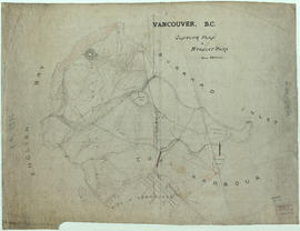
Item is a topographical map of Stanley Park showing various landmarks and locations of buildings.
Vancouver (B.C.). Engineer's Office