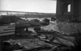
Boats on shoreline under north end of Burrard Bridge
- COV-S168---: CVA 203-1
- Item
- [between 1956 and 1958]
Part of City of Vancouver fonds
863 results with digital objects Show results with digital objects
Boats on shoreline under north end of Burrard Bridge
Part of City of Vancouver fonds

View looking east toward Granville Bridge
Part of City of Vancouver fonds
Item is a photograph showing the shoreline underneath the Burrard Bridge and the view looking east toward Granville Bridge; taken from under north end of Burrard Bridge.

View of shoreline from Burrard Bridge
Part of City of Vancouver fonds
Item is a photograph showing a view looking down on shoreline from Burrard Bridge at the foot of Beach Avenue on east side of Burrard Bridge.

Partial view of shoreline from Burrard Bridge
Part of City of Vancouver fonds
Item is a photograph showing a partial view looking down on shoreline from Burrard Bridge at the foot of Beach Avenue on east side of Burrard Bridge.

Partial view of shoreline under Burrard Bridge
Part of City of Vancouver fonds
Item is a photograph showing a partial view of shoreline under north end of Burrard Bridge.

View of buildings on shoreline from Burrard Bridge
Part of City of Vancouver fonds
item is a photograph showing the foot of Beach Avenue, the shoreline on the north side of Burrard Bridge and Granville Bridge to the east.

View of boats and debris under Burrard Bridge
Part of City of Vancouver fonds
Item is a photograph showing a cluster of boats, sheds and debris at the foot of Beach avenue, taken from Burrard Bridge.

Part of City of Vancouver fonds

Sheet 19 : Maple Street to Richards Street and Drake Street to Third Avenue
Part of City of Vancouver fonds
Item is a section showing Maple Street to Richards Street and Drake Street to Third Avenue. Includes streets, roads, blocks, lots, legal descriptions, parks, schools, the Burrard and Granville Street Bridges, C.P.R. right-of-ways, the Squamish Band reserve, C.P.R. leases and property, and government reserve. Map includes Granville Island. Map is hand coloured to show tax sale property for sale, property with no water, street widening and drainage, replotting, reserved land for schools, reserved land for parks, sundry land, capital assets not including schools and parks, schools, and parks.
Vancouver (B.C.). Office of the City Engineer

Sheet 20 : Granville Street to Ontario Street and Robson Street to Sixth Avenue
Part of City of Vancouver fonds
Item is a section showing Granville Street to Ontario Street and Robson Street to Sixth Avenue. Includes streets, roads, blocks, lots, legal descriptions, businesses, crown leases, city leases, the Granville Street and Connaught (Cambie) Bridges, and the False Creek yards. Map is hand coloured to show tax sale property for sale, property with no water, street widening and drainage, replotting, reserved land for schools, reserved land for parks, sundry land, capital assets not including schools and parks, schools, and parks, as applicable.
Vancouver (B.C.). Office of the City Engineer

Plan to accompany report on proposed bridge at Marpole across North Arm of Fraser River
Part of City of Vancouver fonds
Item is a map showing five possible locations for a bridge across the North Arm of the Fraser River from the city of Vancouver to either Sea Island or Lulu Island.
![Main and Prior [Streets looking] north](/uploads/r/null/0/3/03462b0626b6c8af93a35a586a5d9c2ac7e9fa2097e86d617db56caee769a09c/c197b38f-4169-4a2e-add2-786b6be503ed-A44026_142.jpg)
Main and Prior [Streets looking] north
Part of City of Vancouver fonds

Dunsmuir Viaduct from Main Street
Part of City of Vancouver fonds

Main Street south from Union Street
Part of City of Vancouver fonds
![Main and Union [Streets looking] south](/uploads/r/null/e/2/e28bea0d00b3bbdb55e36ac2e3bc4deb7ff41bf90818bae77f011043e9250eec/c6770d68-30ee-4841-b949-ac8c0e008b40-A44081_142.jpg)
Main and Union [Streets looking] south
Part of City of Vancouver fonds
![Quebec [Street] and Terminal [Avenue looking] north](/uploads/r/null/8/7/875ead16a78cfa138a5c8693519dc12fc41d8c73f56886545182e354bdbbb3f5/5ce5193a-1837-465c-a993-edc170246229-A44212_142.jpg)
Quebec [Street] and Terminal [Avenue looking] north
Part of City of Vancouver fonds
![Begg [Street] at Terminal [Avenue looking] east](/uploads/r/null/a/f/af0ec1f52dc1a3650d0d86dae593103224a89f3d313d1b555932427d9e05d9e0/92862dc1-0c3d-4eae-92f6-5e939059ee3b-A42789_142.jpg)
Begg [Street] at Terminal [Avenue looking] east
Part of City of Vancouver fonds
Photograph taken underneath the Grandview Viaduct
![401 [Trans Canada Highway] and 1st [Avenue looking] west](/uploads/r/null/2/c/2c023307b3aee11723cfd7551b56ab760f08d144d90ab1627176a72f2b2ec9df/a84fe79a-343f-444a-a42a-faabeae62b37-A44409_142.jpg)
401 [Trans Canada Highway] and 1st [Avenue looking] west
Part of City of Vancouver fonds
![[Victoria Diversion and Homer Street looking east]](/uploads/r/null/3/4/348078da64c877f754532ebdf4379965faa82cceb6ff7ff26d01ce242f40f63d/f6160867-b69e-45f7-b029-0975456fc6aa-A44482_142.jpg)
[Victoria Diversion and Homer Street looking east]
Part of City of Vancouver fonds
![[Victoria Diversion and Victoria Drive looking west]](/uploads/r/null/d/8/d8b15bf7dd03bd0c4c8de40e567879b1f16bd4bae4652da3833d66e9b36ccb67/8cb2028a-3b9c-4562-bf8e-b2032bba244b-A44483_142.jpg)
[Victoria Diversion and Victoria Drive looking west]
Part of City of Vancouver fonds
![[Victoria Diversion and Victoria Drive looking west]](/uploads/r/null/c/8/c84eccaf39f6be97dd5b3bb431835c79c03efc325f02699c3f494570cea654cf/1967cc0e-4341-4933-bff7-f35dcb6c19b0-A44486_142.jpg)
[Victoria Diversion and Victoria Drive looking west]
Part of City of Vancouver fonds
Photograph shows the top of a Skytrain car
![[Victoria Diversion and Victoria Drive looking west]](/uploads/r/null/0/2/024aa0f78307129b98a89f1e2466069c8e015789f4317aec2d664bb36e4f6729/3d44b666-c537-4b57-add0-4d8992114ca5-A44487_142.jpg)
[Victoria Diversion and Victoria Drive looking west]
Part of City of Vancouver fonds
![[Victoria Diversion and Victoria Drive looking west]](/uploads/r/null/6/6/66da7fc2550febf722f349dd0a9b330b480714668194f98ca90f0ec4958215c2/fb1312c7-8f3c-43c7-a492-30f832de43e9-A44488_142.jpg)
[Victoria Diversion and Victoria Drive looking west]
Part of City of Vancouver fonds
![[Victoria Drive and Victoria Diversion looking south]](/uploads/r/null/5/b/5b15d4e8098f165ac3b4cf5b562801b9808cd90371a709e9f82b890459e55bc9/edc7d17c-c2b7-4df7-a739-e42a4d2bdd82-A44489_142.jpg)
[Victoria Drive and Victoria Diversion looking south]
Part of City of Vancouver fonds
![[Victoria Drive and Victoria Diversion looking south]](/uploads/r/null/0/2/020040b3ca6619b106a5df9ca2c4860a4858ba03c133a34742ff1390558bb289/78fa0af4-2344-44ac-9f40-c555462c4f32-A44491_142.jpg)
[Victoria Drive and Victoria Diversion looking south]
Part of City of Vancouver fonds
Photograph shows the top of Skytrain cars
![[Victoria Diversion and Victoria Drive looking north]](/uploads/r/null/3/a/3a4bd8559410b0f1a703111367253b678cdd161012ffb849d807a0f0cf455799/19bca63c-4bf5-4823-ae32-c49266168927-A44492_142.jpg)
[Victoria Diversion and Victoria Drive looking north]
Part of City of Vancouver fonds
![[Victoria Diversion and Victoria Drive looking east]](/uploads/r/null/6/2/627c2cfe7b76f4ba514bd1335bd19a931345b5d2abdfd3eaf95e57cc28a52e90/1586efa6-8b4d-4d00-8afa-eba5f1a56204-A44493_142.jpg)
[Victoria Diversion and Victoria Drive looking east]
Part of City of Vancouver fonds
![[Victoria Diversion and Victoria Drive looking east]](/uploads/r/null/c/6/c69f657fa48cb99692e8ba84f69be7da76f560106ba9c744d57a2b93298119f4/b0ad4209-4255-4548-b360-54b6ac81e43a-A44494_142.jpg)
[Victoria Diversion and Victoria Drive looking east]
Part of City of Vancouver fonds
![[Victoria Diversion and Victoria Drive looking west]](/uploads/r/null/f/3/f3ebb38abd688ab2ae53aff39b386158a7051fa46ab630274486288832e3b563/4bb7836f-3757-4a0c-b3d0-dc0c8872b5cf-A44495_142.jpg)
[Victoria Diversion and Victoria Drive looking west]
Part of City of Vancouver fonds
![[Victoria Diversion and Victoria Drive looking north]](/uploads/r/null/2/0/2021a740fcbf4a02a0c9cdd91e1c90fb9d25250143b4604b1ab9c282c85947bd/e95e8b5a-8e0e-4144-8657-82405c6bd4b3-A44496_142.jpg)
[Victoria Diversion and Victoria Drive looking north]
Part of City of Vancouver fonds
![[Victoria Diversion and Homer Street looking east]](/uploads/r/null/6/6/66d764e1b14b3a93193737d7d42f0bdf5f9991f0e296f8ad6a37fcd17980308d/8cc15a94-1bc1-4485-a6fd-d9776155e29b-A44497_142.jpg)
[Victoria Diversion and Homer Street looking east]
Part of City of Vancouver fonds
![[Victoria Diversion and Victoria Drive looking east]](/uploads/r/null/4/f/4fc543adb1580a61f0072be92351a5243b86cd0626fd9ad1c1bc4aaa81b7d02a/6dae785e-233e-4920-97c7-c13f9b6ccfc2-A44498_142.jpg)
[Victoria Diversion and Victoria Drive looking east]
Part of City of Vancouver fonds
Photograph shows the Skytrain
![[Victoria Diversion and Homer Street looking east]](/uploads/r/null/b/4/b4fa26da54f1cd125626c1f4109a4539e6612844d93a3ae1744dd442399ab33d/05acea19-3c91-4cd4-a562-4bfa857ea57a-A44499_142.jpg)
[Victoria Diversion and Homer Street looking east]
Part of City of Vancouver fonds
![[Victoria Diversion and Victoria Drive looking west]](/uploads/r/null/a/1/a146cb6a6ed9ce92f5cc84f931ac777a1488374affd4dcab6d339e190f818cbe/5abb0406-dcad-4347-9705-60c20c45cf3d-A44500_142.jpg)
[Victoria Diversion and Victoria Drive looking west]
Part of City of Vancouver fonds
![Main and Prior [Streets looking] north](/uploads/r/null/c/7/c7a7924a1c9e221e31549b3b45e6199107ca2b73b451777c2d5c6e83d531dc22/49fefe40-c4d6-4717-8db9-c3db7a7f8dcb-A44611_142.jpg)
Main and Prior [Streets looking] north
Part of City of Vancouver fonds
![Boundary [Road] and Vanness [Avenue looking] south](/uploads/r/null/5/7/57b3b5194d06cce1c517a99492bba2c591a0ab830207fdf94bd866dad6ead7d7/e2ed7a74-f813-400a-b135-71a512d67d30-A42881_142.jpg)
Boundary [Road] and Vanness [Avenue looking] south
Part of City of Vancouver fonds
![Boundary [Road] and Vanness [Avenue looking] north](/uploads/r/null/3/5/3552dff6cb8d24136ca2ddfc71d8ce611c58157cc794b0c01f876563f0ecfd55/880f244d-75a5-41ba-a8a1-5886764fae46-A42882_142.jpg)
Boundary [Road] and Vanness [Avenue looking] north
Part of City of Vancouver fonds
![Boundary [Road] and Vanness [Avenue looking] west](/uploads/r/null/0/b/0b59a1e31058cb6cf42e20a1f1cf2976ef966030c6e7f8d609666940019c082b/0418a6de-caf9-40b7-b6e2-99afea108f64-A42884_142.jpg)
Boundary [Road] and Vanness [Avenue looking] west
Part of City of Vancouver fonds
![Boundary [Road] and Vanness [Avenue looking] west](/uploads/r/null/0/4/047e37c256c5334ffa1ce29a3042339481102911baa33bc4bf72f3607fa91894/59262cd8-11e0-49a2-8013-ef71c0422352-A42885_142.jpg)
Boundary [Road] and Vanness [Avenue looking] west
Part of City of Vancouver fonds
![Boundary [Road] and Vanness [Avenue looking] east](/uploads/r/null/7/f/7f1e08b47e92764474e0d7da0f374394b48030ef4d2b6a6d4ee62df82d5c54c8/886b9fad-8212-4938-bc87-256c4819b0d8-A42886_142.jpg)
Boundary [Road] and Vanness [Avenue looking] east
Part of City of Vancouver fonds
![Commercial [Drive],18th [Avenue] and Findlay [Streets looking] north](/uploads/r/null/d/e/dee28f17dabd2b18674e4b11aedd033d7bf0ff83024e8cc7303758a7c0cef250/30210e38-2807-4c14-8e1d-f05b64c4562a-A43184_142.jpg)
Commercial [Drive],18th [Avenue] and Findlay [Streets looking] north
Part of City of Vancouver fonds
Photograph shows a Sky Train bridge
![Commercial [Drive],18th [Avenue] and Findlay [Streets looking] east](/uploads/r/null/d/e/de7df009e4df9c2e1edd135d1e288aab1994238067730bcf81f42935205f207e/8fb1e598-a32a-468c-9194-d4fab8a7cf23-A43186_142.jpg)
Commercial [Drive],18th [Avenue] and Findlay [Streets looking] east
Part of City of Vancouver fonds
Photograph shows a Sky Train bridge
![Fir [Street] and 4th [Avenue looking] north](/uploads/r/null/0/6/06c2318b5623e026d947173357ddde08e80c672a937decce733ca334240cd5c3/be377a1d-2c2b-4015-83f0-36b92f7183a5-A43468_142.jpg)
Fir [Street] and 4th [Avenue looking] north
Part of City of Vancouver fonds
![Fir [Street] and 4th [Avenue looking] east](/uploads/r/null/a/0/a0a706df3c15d1973f4e936ccf8f51ed0fac9ee3ce133569ec46c5c0f24330c0/1a449a48-42ba-4bd6-91ec-d73b68afa763-A43469_142.jpg)
Fir [Street] and 4th [Avenue looking] east
Part of City of Vancouver fonds
Photograph shows part of the Granville Bridge
![Fir [Street] and 4th [Avenue looking] east](/uploads/r/null/c/c/ccf7bd5143da3633e59c3cb49a7a53e2d19c36b78a383fff3c3ee9c09aab2a8f/661be391-8ad9-441d-ba46-274d80d31cf2-A43474_142.jpg)
Fir [Street] and 4th [Avenue looking] east
Part of City of Vancouver fonds
Photograph sghows part of the Granville Bridge
![Heatley and Powell [Streets looking] north](/uploads/r/null/4/8/489d2748263c948f8fcfa4e1ff9fa586f3ffde0a3ff978b9a9f09e83db212be5/cd952647-c652-4c83-911a-d8c98897d38d-A43794_142.jpg)
Heatley and Powell [Streets looking] north
Part of City of Vancouver fonds
![Knight [Street] and Marine [Drive looking] west](/uploads/r/null/9/d/9de5a4670e938a49a2d5bd8e26de026fec78aa050b8acaa80e979eca96765967/42f94c50-340c-47e8-9f17-8dcaa703bedc-A43956_142.jpg)
Knight [Street] and Marine [Drive looking] west
Part of City of Vancouver fonds

Part of City of Vancouver fonds
Image shows the west approach to the Georgia Viaduct, includes a Coca Cola billboard, has two French Maid Products painted advertisements on the south side of the Beatty Street building, and the Sun Tower is in the background.
![Columbia Grain Elevator [at] 2700 Wall St[reet]](/uploads/r/null/c/8/c8cd7e6c3afb916bb1ee20504a9f2328e069842e4bb64d21953cbc1771c417cf/69bf5a92-ccf4-4eb8-ab72-8d56c173178a-A58893_142.jpg)
Columbia Grain Elevator [at] 2700 Wall St[reet]
Part of City of Vancouver fonds
Photograph also shows the Burrard Inlet and the Second Narrows Highway Bridge
![Columbia Grain Elevator [during demolition at] 2700 Wall St[reet]](/uploads/r/null/2/5/25f3f0709f0614e46d3833ae4d26227abe383cca0d4e9101241939bf35b0f693/955469dc-dd85-4dfa-8d9e-9124d145c4cb-A58894_142.jpg)
Columbia Grain Elevator [during demolition at] 2700 Wall St[reet]
Part of City of Vancouver fonds
Photograph also shows the Burrard Inlet and the Second Narrows Highway Bridge