
Plan of Greater Vancouver. British Columbia
- COV-S371---: LEG1153.086
- Item
- 1911
Part of City of Vancouver fonds
Item is a commercially printed map which has been annotated to depict various Burrard Inlet crossings and underwater features.
6 results with digital objects Show results with digital objects
Plan of Greater Vancouver. British Columbia
Part of City of Vancouver fonds
Item is a commercially printed map which has been annotated to depict various Burrard Inlet crossings and underwater features.

Part of City of Vancouver fonds
Item is a map which depicts the waterworks infrastructure in Vancouver such as pipelines, tunnels, intakes, proposed reservoirs, etc.

Plan showing relative position of different water districts
Part of City of Vancouver fonds
Item is a map which depicts the boundaries between the various water districts between the Capilano River and the North Arm of Burrard Inlet.
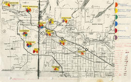
General overview of high-tech industry demographics
Part of City of Vancouver fonds
Item is a map annotated to show technology industry activities in Lower Mainland municipalities. Categories of activity are design/fabrication, system design/consulting, research/development, education, fabrication/manufacturing, and other. Item includes a list of the number of firms in each location.
![Vancouver's high-tech industry location map plus G.V.R.D. [Greater Vancouver Regional District] d...](/uploads/r/null/2/b/7/2b7c912f51dd7827d1a0ac60042357a631d2c8fdc3487bc37f286d2945c4ea4c/7a17e6a4-d593-45c5-9625-f03c471efb68-LEG1362_142.jpg)
Part of City of Vancouver fonds
Item is a map annotated to show locations of Vancouver technology firms. Categories of activity are system design/consulting, fabrication/manufacturing, design/fabrication, research/development, and other. Base map is a street map produced by the Engineering Department.

Capilano and Seymour water sheds
Part of City of Vancouver fonds
Item is a map showing Capilano and Seymour water sheds, reservoirs, pipelines, lot numbers and major roads in the area from Howe Sound to Port Moody and Britannia to Delta. The item includes information about the drainage area, annual precipitation and annual runoff associated with the Capilano and Seymour water sheds.