
Topographic map of Downtown Vancouver and the East End
- COV-S365-: MAP 698
- Item
- 1887-1913
Part of City of Vancouver fonds
Item is a map showing two sets of topographic contour lines, streets, and block numbers (in Roman numerals) in the area from Robson Street to Raymur Avenue and Coal Harbour/Vancouver Harbour to False Creek.
![[No. 6 La France hose wagon rammed against tree following accident at Pender and Burrard Streets]](/uploads/r/null/5/0/2/502023e0a13c58e7d816b556ebf58fb12dc828e86d535dc7450e4c1236d2fe14/e1bc9b81-72d6-4074-a76a-ba9e61cca2ac-CVA354-044_142.jpg)
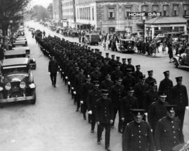
![[Firefighters and motorized equipment in front of Firehall No. 2, 754 Seymour Street]](/uploads/r/null/1/a/2/1a2f1373f1d648856294c4009aca38f93d121927679c379a3ab4dd4db0fd8128/e7169b57-02b8-4cc5-a5d8-122e1c212954-CVA354-043_142.jpg)
![[Gathering of fire engines to show "Fully Motorized" occasion at C.P.R. freight yards]](/uploads/r/null/4/6/4/464e3333148bebd4439aa317794f2892018b4cdc4c4f2c3e8cfed544422a76d1/ac7aecd4-f952-4786-9697-0f24efacfc7c-CVA354-049_142.jpg)
![[Firefighters and equipment assembled in front of Firehall No. 2, Seymour Street]](/uploads/r/null/e/c/9/ec99f99730399ff2867febe28c8d8486234f3580f882388b74d21a8437aee50b/a286e792-0d1f-4477-a0ce-ce3721f8ceb5-CVA354-051_142.jpg)


![[Chief C.W. Thompson seated in Vancouver Fire Department automobile by Court House]](/uploads/r/null/9/5/7/957086fef640611a76ba82f9d85c3c033e0817a97acff07df0202d93930b6df9/d8263eca-24ec-48ab-bd53-3871f1b75d1d-CVA354-389_142.jpg)
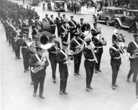
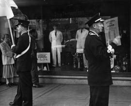
![[Group portrait of Firemen's Band on steps of Vancouver Court House]](/uploads/r/null/6/7/1/671ad823231c96cc5d64acf1461780da510a44b5779df01a4f7d6f2afba9aee6/28cbea32-cd96-49d3-8b15-a1440201704f-CVA354-101_142.jpg)


![8:06 pm Monday Dec. 26/55 1131 Beach Ave [view of firefighters putting out house fire]](/uploads/r/null/6/a/1/6a12647ac0f56355d27068df38766b24072ec21727a47cb1720c0a4776f47b18/e674c369-21ab-43ea-b482-8ebef2f0b301-CVA354-164_142.jpg)
![8:06 pm Monday Dec. 26/55 1131 Beach Ave [view of firefighters putting out house fire]](/uploads/r/null/5/5/e/55e6e5ee078efef5b8db66756db934b5a8e587d96615b516795cef0686bee29f/c1d72d91-cf49-4366-baf1-ce1807a52e46-CVA354-165_142.jpg)
![8:06 pm Monday Dec. 26/55 1131 Beach Ave [view of firefighters putting out house fire]](/uploads/r/null/2/5/3/25343a0e40da6feefe9d0a9cc2d574f77a399b538e008d943a17a8abad426e4c/9757c2d3-cdc0-4d2e-9c73-a6eb390a27ac-CVA354-166_142.jpg)
![8:06 pm Monday Dec. 26/55 1131 Beach Ave [view of firefighters putting out house fire]](/uploads/r/null/c/a/a/caa5f06f73ca6df11bac94ba2d2769850d20b0eb132ab978c475a65159c47fd3/17b3b295-3ccf-44d6-b9fb-6edd53c78e44-CVA354-163_142.jpg)


![[Firefighters removing body of suicide victim from marquee of Georgia Hotel]](/uploads/r/null/7/f/b/7fb1c694b66ddd4ef6e5a8cb68817475d2d5efcc733c4eb62c2fcda0dba871c8/e6ddfc41-d1fb-49ef-a336-489cab29ed27-CVA354-171_142.jpg)


![C.B.D. [Central Business District] trip trace density chart](/uploads/r/null/6/b/4/6b4dfcd5710a8add68045b374b1df6e0649e8577a53d23070c9494276c76c3fd/0e0776f3-ca72-4c99-8121-6e7293b90cee-LEG26_142.jpg)


![[View of new fire engines parked in front of Firehall No. 1, West Georgia at Hamilton]](/uploads/r/null/f/d/fd79a139fd0b50167cb4c48ec50d0cb38f48d9c3a387d325aa232940c6b6de8a/17bbadfb-d23c-410a-b06b-0efcf6db159d-A43354_142.jpg)
![[Lot beside Big Frank's at 628 Howe Street]](/uploads/r/null/e/2/9/e2972786760e7824c2d337820d9bc9ca113fe77c8d87f208e6786d4a50d1407e/a3de96e9-47a8-400c-bb27-7ccc8214ab4a-CVA1095-09185_142.jpg)
![[Granville Street and West Georgia Street intersection, 1 of 2]](/uploads/r/null/4/1/4/41481ea9427e9656ce03c71d199d8893a9c5fede384c316894f894c80854054d/b910d92e-fa11-40f5-97fb-d324fad1e0dc-CVA1095-09194_142.jpg)
![[Businesses on 700 and 800 block West Georgia Street]](/uploads/r/null/1/6/0/160cd3809b0cb71ba358b5a82da575ade876d84404161c2e6c63f619529e615b/5fe0474a-9ae6-41bf-b9ec-0603266c912e-CVA1095-09179_142.jpg)
![Block 42, D.L. 541 [Rear view of buildings]](/uploads/r/null/f/e/d/fedd5371ee50997ed1b9b3a5db2c280b625e37d09c3de43d46d5afcd17c1cfd8/d889883d-27b3-47a6-ac92-4ba3451735e1-CVA1095-09181_142.jpg)
![[Alley behind 633-637 Granville Street - Chapman's and Tip Top Tailors]](/uploads/r/null/9/b/f/9bfaad353bb0922508142df146a919bbeb76b777b94221aefa789b17f293e935/3d9921c1-adbe-4bfb-85ff-3fdd7e4b3e2b-CVA1095-09182_142.jpg)
![[View of buildings on Howe Street and Dunsmuir Street]](/uploads/r/null/6/c/8/6c818fcd36afa56ef202c68f558f3bb58b23a9bf71d7aa4be2001160e6a13cc0/968ce400-1b04-454f-8a5f-05474b594df2-CVA1095-09183_142.jpg)
![Block 42, D.L. 541 [Alley]](/uploads/r/null/a/5/1/a516c443ec60a88a32d6a9931c39b878ed990bd281ab182237aabc39af0b649a/f79bbba4-4812-482b-85a7-368a5ee52fb0-CVA1095-09191_142.jpg)
![[Alley behind 600 block Granville Street]](/uploads/r/null/d/c/7/dc735d76e953cae1c88704c6ffb1b67db4e8f582648bdd7c8dc1439d3b116967/ca619f9f-8515-4059-9aba-8bb4e0370576-CVA1095-09193_142.jpg)
![[Granville Street and West Georgia Street intersection, 2 of 2]](/uploads/r/null/d/8/e/d8eb1418e08df9b7b0e31ee22079849d0948adb686216b2e6cf4a63490f839f3/489a6af7-846e-44ad-ad64-aa6379f2ebd5-CVA1095-09195_142.jpg)