
Aldermen Harry Rankin, Michael Harcourt, John J. Volrich, Boyce and Kennedy taking Oath of Office
- COV-S532-F09-: CVA 283-10
- Item
- Jan. 8, 1975
Part of City of Vancouver fonds
Aldermen Harry Rankin, Michael Harcourt, John J. Volrich, Boyce and Kennedy taking Oath of Office
Part of City of Vancouver fonds

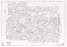
City of Vancouver, British Columbia. Downtown Vancouver
Part of City of Vancouver fonds
Item consists of a topographical map depicting the downtown area north of 7th Avenue and west of Hawks St./Fraser St.
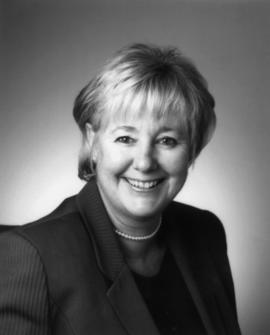
Judy Rogers, City Manager 1999-2008
Part of City of Vancouver fonds
Part of City of Vancouver fonds

Part of City of Vancouver fonds
Part of City of Vancouver fonds

Part of City of Vancouver fonds
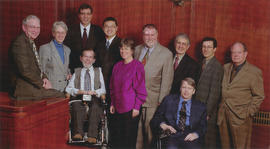
Vancouver City Council 2002-2005
Part of City of Vancouver fonds
Item is a photograph showing the mayor and council from 2002 to 2005. Pictured (L-R): Mayor Larry W. Campbell, Anne Roberts, Tim Stevenson, Tim Louis, Raymond Louie, Ellen Woodsworth, David Cadman, Fred Bass, Sam Sullivan, Peter Ladner, Jim Green.

Part of City of Vancouver fonds

Part of City of Vancouver fonds

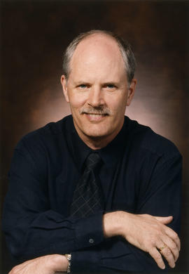
Kenneth Dobell, City Manager 1990-1998
Part of City of Vancouver fonds
![City of Vancouver B.C. area map [Cartier St. to 49th Ave. to Wallace St. to Fraser River]](/uploads/r/null/b/9/0/b90512d5b7ab999c429946e004afaeefa347e648d05cbe127e548941cf053492/4bf26a05-6451-4c58-be1b-4491a36347e0-LEG1493_142.jpg)
City of Vancouver B.C. area map [Cartier St. to 49th Ave. to Wallace St. to Fraser River]
Part of City of Vancouver fonds
Item consists of a map depicting streets, transportation infrastructure, parks, harbour headlines and other geographic features.
![City of Vancouver B.C. area map [Inverness St. to 37th Ave. to Granville St. to 57th Ave.]](/uploads/r/null/b/b/b/bbb5627e84fb0e74ba863c698c350f1c776909c66fe285c49945f91a0bde6e48/94cc8c2d-2d95-4552-a8e4-3a917b38ed69-LEG1493_142.jpg)
City of Vancouver B.C. area map [Inverness St. to 37th Ave. to Granville St. to 57th Ave.]
Part of City of Vancouver fonds
Item consists of a map depicting streets, transportation infrastructure, parks, harbour headlines and other geographic features.
![City of Vancouver B.C. area map [Granville St. to King Edward Ave. to Camosun St. to 49th Ave.]](/uploads/r/null/e/4/e/e4ea196e799a3d1ee8d3079227c9235d74e38168dd3aff7c4b7a93c85167a9b5/621c46bb-2cd2-48dd-a571-9ec8eba8daa2-LEG1493_142.jpg)
City of Vancouver B.C. area map [Granville St. to King Edward Ave. to Camosun St. to 49th Ave.]
Part of City of Vancouver fonds
Item consists of a map depicting streets, transportation infrastructure, parks, harbour headlines and other geographic features.
![City of Vancouver B.C. area map [Granville St. to English Bay to Camosun St. to King Edward Ave.]](/uploads/r/null/7/5/d/75d60ce8c1fe40f83cb5b7de4529e76beb62bdafa0d97adf3107aa442fb8bd5f/40e84138-eca4-4329-ba26-49c60dbbbf56-LEG1493_142.jpg)
City of Vancouver B.C. area map [Granville St. to English Bay to Camosun St. to King Edward Ave.]
Part of City of Vancouver fonds
Item consists of a map depicting streets, transportation infrastructure, parks, harbour headlines and other geographic features.
![City of Vancouver B.C. area map [Boundary Rd. to Burrard Inlet to Heatley Ave. to 2nd/5th Ave.]](/uploads/r/null/1/9/8/198a72e4b463634523e5e77cb805ac077ff62a32d5ea05b80b290b127914f37d/0ac9e098-c69e-4196-b616-3cbb4b65d289-LEG1493_142.jpg)
City of Vancouver B.C. area map [Boundary Rd. to Burrard Inlet to Heatley Ave. to 2nd/5th Ave.]
Part of City of Vancouver fonds
Item consists of a map depicting streets, transportation infrastructure, parks, harbour headlines and other geographic features.
![City of Vancouver B.C. area map [Boundary Rd. to 32nd Ave. to Inverness St. to 54th Ave.]](/uploads/r/null/4/1/9/41967d0a3fb3b7bb9709efd337b0392ff4c58c5e8f835dd04e8e292d202fa135/46a3719b-4bd0-4fa2-858e-37480c570f7c-LEG1493_142.jpg)
City of Vancouver B.C. area map [Boundary Rd. to 32nd Ave. to Inverness St. to 54th Ave.]
Part of City of Vancouver fonds
Item consists of a map depicting streets, transportation infrastructure, parks, harbour headlines and other geographic features.
![City of Vancouver B.C. area map [Point Grey]](/uploads/r/null/f/f/3/ff34e5b2e9358c8cd595440a33fee383fb78e50a4a5bd338548ffe242f0d6872/12eef633-8974-41fa-ab84-57f3e747b090-LEG1493_142.jpg)
City of Vancouver B.C. area map [Point Grey]
Part of City of Vancouver fonds
Item consists of a sheet with two maps, each depicting streets, transportation infrastructure, parks, harbour headlines and other geographic features. Map N shows the area bounded by Camosun St. to English Bay to Drummond Dr. to 16th Ave. Map P shows the area bounded by Wallace St. to the University Endowment Lands to the Musqueum Reserve to the Fraser River.
Part of City of Vancouver fonds
Item consists of a map depicting streets, transportation infrastructure, parks, harbour headlines and other geographic features.
![City of Vancouver B.C. area map [Inverness St. to 57th Ave. to Cartier St. to Fraser River]](/uploads/r/null/8/5/4/8544d9a63a23de971d0737695ffff0ba8470d708780abff07e44cd080ee38c4d/42dcb1f3-2fce-4372-82e4-68410ccb122a-LEG1493_142.jpg)
City of Vancouver B.C. area map [Inverness St. to 57th Ave. to Cartier St. to Fraser River]
Part of City of Vancouver fonds
Item consists of a map depicting streets, transportation infrastructure, parks, harbour headlines and other geographic features.
![City of Vancouver B.C. area map [Heatley Ave. to Burrard Inlet to Maple St. to 4th/6th Ave.]](/uploads/r/null/7/f/5/7f5dab9b372be433325b43cd1c75ae4f7509ca456ae9e74bb78d27d76b850748/fc10b0d6-7525-4483-9212-f7172a93114c-LEG1493_142.jpg)
City of Vancouver B.C. area map [Heatley Ave. to Burrard Inlet to Maple St. to 4th/6th Ave.]
Part of City of Vancouver fonds
Item consists of a map depicting streets, transportation infrastructure, parks, harbour headlines and other geographic features.
![City of Vancouver B.C. area map [Boundary Rd. to 54th Ave. to Inverness St. to Fraser River]](/uploads/r/null/c/a/0/ca079c63d386e99664763d5674f6bdf8b5f822bd670e5531b02bb917e14de7bf/1d29872a-3121-4986-b9c0-229d0c2cd3a1-LEG1493_142.jpg)
City of Vancouver B.C. area map [Boundary Rd. to 54th Ave. to Inverness St. to Fraser River]
Part of City of Vancouver fonds
Item consists of a map depicting streets, transportation infrastructure, parks, harbour headlines and other geographic features.
![City of Vancouver B.C. area map [Clark Dr./Inverness St. to 6th Ave. to Granville St. to 37th Ave.]](/uploads/r/null/2/5/2/252edff70e6c084c05c63f810d048c09215e22656c63906cab4b80945bdae68c/916807b0-00b3-491c-b26f-1668281abc3c-LEG1493_142.jpg)
City of Vancouver B.C. area map [Clark Dr./Inverness St. to 6th Ave. to Granville St. to 37th Ave.]
Part of City of Vancouver fonds
Item consists of a map depicting streets, transportation infrastructure, parks, harbour headlines and other geographic features.
![Abbott and Cordova [Streets looking] north](/uploads/r/null/8/a/8aab879fc7571cea390137d122ac3a89381071b678502757448c72f1fa930e4f/7cda2f7c-4836-4e9a-bb47-04f727a330f0-A42710_142.jpg)
Abbott and Cordova [Streets looking] north
Part of City of Vancouver fonds
![Abbott and Cordova [streets looking] east](/uploads/r/null/7/0/707fb0b0f3ba16b327f9d40a0a0a94b3f918509e20ac40ab413928d75ff1b6a8/c28af97b-ce7e-4953-b6ff-6e0979093ac1-A42711_142.jpg)
Abbott and Cordova [streets looking] east
Part of City of Vancouver fonds
Photograph shows Sissons Sporting Goods
![Abbott and Hastings [streets looking] north](/uploads/r/null/5/8/58a47efab97572b4c13cd6b981dd3dac02110898a57c7c528946196e79ba9346/863bf6d2-596f-499c-868a-28abd249fb85-A42714_142.jpg)
Abbott and Hastings [streets looking] north
Part of City of Vancouver fonds
Photograph shows Woodwards
![Alder [Street] and 6th [Avenue looking] west](/uploads/r/null/9/c/9c3510984925b6c73b0f03fe9efc1a5f0c4f319bc1012d03aa9caa3e5b60cb47/373b8340-f09c-4f8c-b47d-a21aa18ae822-A42723_142.jpg)
Alder [Street] and 6th [Avenue looking] west
Part of City of Vancouver fonds
![Alma [Street]and Broadway [looking] south](/uploads/r/null/4/d/4dafffe711c2871a06198b0ffd371738a92f41b9a756e865cf32b41bb712a733/f1a34532-ad4a-4a7f-a67d-e800c9132525-A42726_142.jpg)
Alma [Street]and Broadway [looking] south
Part of City of Vancouver fonds
![Alma [Street] and Broadway [looking] north](/uploads/r/null/f/e/fe19941ed63249d77fd1b5a19cf8c68f6469fc9a1fa766c7170f69506850e2d1/d27e2826-b62d-4fd1-aac2-de85149a4ae5-A42728_142.jpg)
Alma [Street] and Broadway [looking] north
Part of City of Vancouver fonds
![Main and Union [Streets looking] west](/uploads/r/null/e/b/eb84964dbf933c1442a61ec0968b329a7e271791ed535386b9f0a6643a914aac/80bdc5d8-5b0b-4ea9-bf2d-637b34a3c532-A44078_142.jpg)
Main and Union [Streets looking] west
Part of City of Vancouver fonds
![Moberley [Road] and 6th [Avenue looking] west](/uploads/r/null/f/e/fe05afaf19cf8c1575b65911683a135a2f1903e7f649bd375057bba80e398326/eb040ea1-5d1e-4016-a9dd-9eb722bca801-A44109_142.jpg)
Moberley [Road] and 6th [Avenue looking] west
Part of City of Vancouver fonds
![Marine [Drive] and 41st [Avenue looking] east](/uploads/r/null/9/2/9295290dc76739cb2ca54e7bdb040c637cc703d3a692dd9055a60b02ff9bfcdc/fb404960-0fce-4148-bfb7-271e44273788-A44111_142.jpg)
Marine [Drive] and 41st [Avenue looking] east
Part of City of Vancouver fonds
![Nanaimo and Hastings [Streets looking] east](/uploads/r/null/4/2/4277dd885fd35a7516f0ec6c916d53646e052b31145d0bebabff2d7b7362a76a/421cb517-8ee7-43a8-b6ed-3848f71d6f74-A44140_142.jpg)
Nanaimo and Hastings [Streets looking] east
Part of City of Vancouver fonds
![Nanaimo [Street] and Kingsway [looking] north](/uploads/r/null/2/5/2585376fed1c2542b3b194ebbf7ed615c8c9a113d4b53ffeff70af26fbcd2c99/a1c0cde3-fbc5-4841-b759-d67effa69418-A44143_142.jpg)
Nanaimo [Street] and Kingsway [looking] north
Part of City of Vancouver fonds
![Nanaimo [Street] and Broadway [looking] east](/uploads/r/null/2/6/2628a624a25e6c520d99577488c0e80df649937260c1beddad9eb25076d852ea/e83ca108-1737-419f-b058-c79bcec86c10-A44151_142.jpg)
Nanaimo [Street] and Broadway [looking] east
Part of City of Vancouver fonds
![Oak [Street] and Broadway [looking] south](/uploads/r/null/c/b/cbba5b7775083151ea5354bee5259b9143f7e4f8691955d3c7e07e4548460ba2/9ef14bc0-0b73-418f-8c16-b2d213074f5f-A44160_142.jpg)
Oak [Street] and Broadway [looking] south
Part of City of Vancouver fonds
![Oak [Street] and 12th [Avenue looking] north](/uploads/r/null/e/7/e716819cc94a5e03baff80d4bd7010d2d565ab4cf7f41b49c52ab9b32b1afb86/596b5506-7b75-496e-9e87-2ad483b10197-A44168_142.jpg)
Oak [Street] and 12th [Avenue looking] north
Part of City of Vancouver fonds
![Oak [Street] and 57th [Avenue looking] east](/uploads/r/null/8/a/8a6aa800afe04e85d476cbf5660ddc260605aab9249bdd6a3dd799d2e863d1ee/95fe19c6-8e3f-4efd-8909-7ddd8a24fb99-A44180_142.jpg)
Oak [Street] and 57th [Avenue looking] east
Part of City of Vancouver fonds
![Oak [Street] and 49th [Avenue looking] east](/uploads/r/null/3/6/36c0d8fe26aff01d6b4e97ed070e6e7bb6570a35b46da642c7f40d9c9b16469f/052db798-9c96-4c2a-98fe-d8391e2d97ef-A44184_142.jpg)
Oak [Street] and 49th [Avenue looking] east
Part of City of Vancouver fonds
![Oak [Street] and 41st [Avenue looking] west](/uploads/r/null/5/1/519508db1d558c229e1a03f7a01569c429f120d55a070845879fb39cd2c7596f/7c3a83ec-9967-46d9-84b2-2136840d4683-A44186_142.jpg)
Oak [Street] and 41st [Avenue looking] west
Part of City of Vancouver fonds
![Oak [Street] and 19th [Avenue looking] south](/uploads/r/null/6/1/61f3736c303098eac454d80524d35325f63db23beb77e13bc97e285af19109de/ae681077-6eaa-4fe7-b0f5-7766d5d8c893-A44192_142.jpg)
Oak [Street] and 19th [Avenue looking] south
Part of City of Vancouver fonds
![Oak [Street] and 19th [Avenue looking] east](/uploads/r/null/9/5/958b359880cabffa4221f400cf6b2e3fda191212153638fa8fc68e1be9df6068/cde84a7d-2c6a-49bd-a1aa-dadf604c544d-A44193_142.jpg)
Oak [Street] and 19th [Avenue looking] east
Part of City of Vancouver fonds
![Oak [Street] and 19th [Avenue looking] north](/uploads/r/null/2/5/255389ea1b491ecf8b5e3ae4b369fe7f2c48257da97966abcbb833591236662b/6351f1e7-630d-4e65-b00f-01403fae7621-A44195_142.jpg)
Oak [Street] and 19th [Avenue looking] north
Part of City of Vancouver fonds
![Prince Edward [Street] and King Edward [Avenue looking] north](/uploads/r/null/5/a/5a7760811915d5634cc3848ae9b5e6c7016fb92edc7af553c05da4d3789517c4/c03b8a27-0513-415f-a595-cda89f23b531-A44204_142.jpg)
Prince Edward [Street] and King Edward [Avenue looking] north
Part of City of Vancouver fonds
![Quebec [Street] and 2nd [Avenue looking] north](/uploads/r/null/3/9/3934ec11312248adb169b0dc88e19898613cf86e4350f5c84f4ba48f46aceed8/38426e53-bcfe-4e86-a4f4-ecbf7607e86c-A44209_142.jpg)
Quebec [Street] and 2nd [Avenue looking] north
Part of City of Vancouver fonds
![Richards and Cordova and Water [Streets looking] east](/uploads/r/null/e/9/e9b75b48480e6f90070ea491afb7aa29cdcedb2be03f9c22fe46c39b98517714/a634c145-0cd6-4953-ae80-08d3fd212497-A44221_142.jpg)
Richards and Cordova and Water [Streets looking] east
Part of City of Vancouver fonds
Photograph shows the Holland Block
![Richards and Davie [Streets looking] north](/uploads/r/null/e/2/e2dbda49971bcbc3d4114641c310a2ffdd0e8e32b8be2befb4ccd62ad9ea4211/81510d38-c18c-4b4c-b32b-1a0b423fdfc1-A44231_142.jpg)
Richards and Davie [Streets looking] north
Part of City of Vancouver fonds
![Renfrew [Street] and 1st [Avenue looking] south](/uploads/r/null/d/e/de3859eb11f1df83a9c4d59a891040602fb18eb4e341f4fa39d2d8ce7419e229/f97d1c31-f712-4e87-9c4a-420c1fed00d4-A44244_142.jpg)
Renfrew [Street] and 1st [Avenue looking] south
Part of City of Vancouver fonds
![Renfrew [Street] and 22nd [Avenue looking] east](/uploads/r/null/4/c/4c9243ddc4a2d00e2ce825e259ecdc16d238f5b8734cba6f26bb96d888499ba5/e49fe29e-b507-44c6-9a74-c7cb2b720ad4-A44247_142.jpg)
Renfrew [Street] and 22nd [Avenue looking] east
Part of City of Vancouver fonds
![Renfrew [Street] and 22nd [Avenue looking] west](/uploads/r/null/9/2/92fdc69591b136091c94e24cc51493d0b40f3cd775c9ae7ff219265e5a6b1242/d4b106e3-049f-4c9c-80f9-d307042fb938-A44248_142.jpg)
Renfrew [Street] and 22nd [Avenue looking] west
Part of City of Vancouver fonds