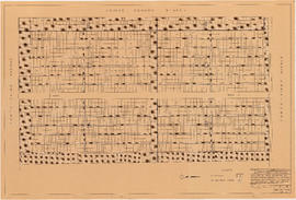
Key plan showing Mountain View Cemetery, Vancouver, B.C.
Key plan showing Mountain View Cemetery, Vancouver, B.C.
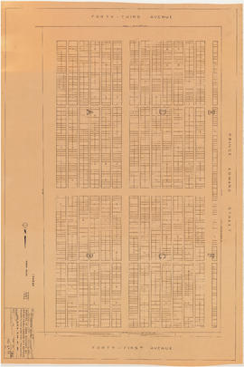
Portion of area bounded by 41st Avenue, Prince Edward Street & 43rd Avenue
Portion of area bounded by 41st Avenue, Prince Edward Street & 43rd Avenue
[Aerial survey photograph]
[Aerial survey photograph with body of water]
[Aerial survey photograph]
[Aerial survey photograph]
[Aerial survey photograph with river]
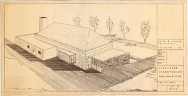
Preliminary plan for Vancouver Crematorium
Aerial view of Strathcona to Downtown, with Georgia Viaduct, False Creek, Canadian Central Station and Canadian Western Cooperage sawmill
Aerial view of Downtown Vancouver, West End and Yaletown, with Granville Street Bridge and Burrard Street Bridge, and C.P.R. [Canadian Pacific Railway] train yards
Aerial view of Mount Pleasant and False Creek, at Main Street and 2nd Avenue, with Canadian Central Station and Opsal Steel
Aerial view of False Creek, Fairview and Granville Island, at Lamey's Mill Road, West 6th Avenue and Birch Street, with Granville Street Bridge
Aerial view of Strathcona, between Jackson and Gore Avenues at Prior, with Canadian Pacific Railway train yards, Lord Strathcona Elementary, Oppenheimer Park, First United Church and St. James Anglican Church
Aerial view of Vancouver City Hall and residential housing, at Cambie Street and 12th Avenue, with Model and Normal School (City Square Mall) and Blessed Sacrament Parish
Aerial view of Fairview at the foot of Granville Street Bridge, with Granville Island and industrial buildings
Aerial view of False Creek at Cambie Street Bridge and 2nd Avenue with Canadian Western Cooperage sawmill
Aerial view of Vancouver City Hall and residential housing, facing east, on Cambie Street
Aerial view of Vancouver City Hall and residential housing, facing southwest, at Cambie Street and 12th Avenue
Aerial view of Vancouver City Hall and residential housing, facing northeast, at Cambie Street and 12th Avenue
Aerial view of Mount Pleasant, False Creek, at Main Street and Terminal Avenue, with Canadian Central Station, Opsal Steel, Murrin Substation and Georgia Viaduct
Aerial view of False Creek, facing Mount Pleasant and Fairview, with Cambie Street Bridge, Vancouver General Hospital, Vancouver City Hall
Close aerial view of Vancouver City Hall, with Cambie Street and cars
Aerial view of Downtown Vancouver with Stanley Park, North Vancouver, West Vancouver, North Shore mountains and Burrard, Granville and Cambie Street bridges
Aerial view of False Creek, Fairview between Granville Street and Burrard Street Bridge, at 1st Avenue and Fir Street, with marina and industrial buildings
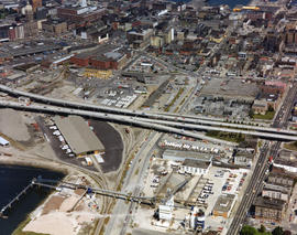
Aerial view of False Creek, Downtown Eastside and Chinatown, with Georgia Viaduct, at Quebec and Main Street
Aerial view of Downtown Vancouver and West End, facing south, with Burrard Street and Granville Street bridges, and law courts under construction
Aerial view of False Creek at Terminal Avenue and Quebec Street, with Georgia Viaduct, Main Street and Canadian Western Cooperage sawmill
Aerial view of False Creek, at Quebec Street and Terminal Avenue, with Georgia Viaduct, Main Street, Murrin Substation, and log booms
Aerial view of False Creek at Stamp's Landing with Cambie Street Bridge and Heather Civic Marina and Yaletown Marina
Aerial view of False Creek at 2nd Avenue with Cambie Street Bridge and Canadian Western Cooperage sawmill
Aerial view of Mount Pleasant, False Creek, facing west, at 1st Avenue and Quebec Street with 2nd Avenue, Main Street, Opsal Steel and Cambie Street Bridge
Vancouver City Hall, 453 West 12th Avenue
Hotel Vancouver from Burrard Street and Georgia Street, with Christ Church Cathedral
Aerial view of Downtown, with future site of Eaton's Centre, Pacific Centre, Robson Square and Law Courts indicated
Aerial view of False Creek and Yaletown with Cambie Street Bridge, marina, C.P.R. [Canadian Pacific Railway] train yards and CBC [Canadian Broadcasting Corporation] building
Aerial view of Mount Pleasant at Great Northern Way, 2nd Avenue and Main Street, with railroad tracks, industrial buildings and warehouses
Aerial view of Downtown Vancouver, Stanley Park and False Creek, North Shore Mountains, North Vancouver, West Vancouver, Lions Gate Bridge, Cambie Street Bridge, and law courts under construction
Aerial view of Downtown Vancouver and False Creek, with Fairview, Stanley Park, Cambie Street Bridge, North Vancouver, Lions Gate Bridge, and law courts under construction
Aerial view of Downtown Vancouver and False Creek, between Burrard Street and Granville Street Bridge, with train bridge and Granville Island
Aerial view of Downtown Vancouver, West End and Yaletown, with Cambie Street and Granville Street bridges, train yards, Roundhouse, Granville Island and law courts under construction
Legend [for colour coding land use]
Vancouver British Columbia. Major street plan
Plan of District Lot boundaries. City of Vancouver, B.C.


![[Aerial survey photograph]](/uploads/r/null/f/a/fab195a7fc233deb2d6de7cd7adbb1c17e581561907ad4326ec3e70802b8053e/7186442f-d249-4e5f-9aca-ac698f0376fd-A40953_142.jpg)
![[Aerial survey photograph with body of water]](/uploads/r/null/0/8/08c3cd4f3f862932c7f8892684151a7b8147e1d257a9a70930541c72b57f2f9b/348a6a46-4362-459e-ac8b-e210bffcfe4f-A40990_142.jpg)
![[Aerial survey photograph]](/uploads/r/null/8/6/86329ac6a4aa2d72519aa3411a56ef7fc696546a8bd1c916228309a90e76067a/889ed9ec-97c7-4317-9c11-53a8c123430d-A40954_142.jpg)
![[Aerial survey photograph]](/uploads/r/null/5/d/5d61d720b2a88dce52e09ab49a7ef4942b0eac1405c7b4e765e3beda6f25999a/b0d55cc5-84f3-47e9-919c-a036db614315-A48057_142.jpg)
![[Aerial survey photograph with river]](/uploads/r/null/f/e/fe98d2abefe97f551eec30eb0326bbb273e1ee059396e9f6909ffc1984a9f7ea/6786642e-fcc8-4f00-bf6d-26d122fae5ec-A38258_142.jpg)


![Legend [for colour coding land use]](/uploads/r/null/3/1/2/3120f4f71566883ae774f5f08ae6795bc55fcd40d9f4bdd29f8f25dc782e0a9f/89bc7dbc-376d-43ba-bc88-a0fda629d99a-LEG1153_142.jpg)


