Projects no. 1 and 2 maps and plans
- COV-S305--
- File
- 1960-[ca. 1965]
Part of City of Vancouver fonds
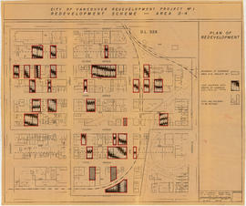
File consists primarily of maps pertaining to redevelopment project 1, areas A and D, but also contains two maps from project 2. Maps include identification plans of property to be acquired; boundaries of clearance areas; general and detailed redevelopment plans; and maps showing the layout of existing and proposed utilities.


![Oak [Street] and 12th [Avenue traffic controller]](/uploads/r/null/0/f/5/0f589c7ee875b1376263297d012def11f50f06dc8c8874cab963d767c4d2228b/9eeb46da-c329-44f9-9942-36ae5be7447c-2019-103.0265_142.jpg)
![Oak [Street] and 12th [Avenue intersection, 1 of 4]](/uploads/r/null/7/5/6/756fcab838ddb70f9c8cc25680cfb7f367acacc5fe3dd748e4f4480324aa11a0/469601e7-8ad9-4d72-a971-864d91bcba8b-2019-103.0266_142.jpg)
![Oak [Street] and 12th [Avenue intersection, 2 of 4]](/uploads/r/null/1/e/1/1e17dd9263a2e792e37fc3f576100c7cbde4936974913dc70cd7dd173e2d8adc/c92cf20e-674d-4c24-8963-fadb5c2db389-2019-103.0267_142.jpg)
![Oak [Street] and 12th [Avenue intersection, 3 of 4]](/uploads/r/null/8/4/e/84e1f5c7bbab2384848edf9993fdcf6f1b0e035348f0ac8713d5ee5533f748da/4f452c63-8345-4b7e-8220-0841e6b96c77-2019-103.0268_142.jpg)
![Oak [Street] and 12th [Avenue intersection, 4 of 4]](/uploads/r/null/f/5/9/f599bb9baa04c327e9fb8352cfe4b1bf61ee32aa8f6639d68ddf1d470f2b8158/15dd9d84-02c4-4fd8-999d-05a4439a47a9-2019-103.0269_142.jpg)
![Burrard [Street] and Broadway [intersection, 1 of 4]](/uploads/r/null/4/b/7/4b7795fe69ac20a9106ff967ac820aaf216a597e5e7155841ff7f2db34a70332/1dc5d383-06ed-4e0d-8d21-32be384ae7f4-2019-103.0609_142.jpg)
![Burrard [Street] and Broadway [intersection, 2 of 4]](/uploads/r/null/4/a/4/4a47c17d5f3f36193f647e29f95d42aca9df934e7377d8b85a575e808f6b12b1/e6bfd0da-da6f-4865-84c4-7e9349b996b9-2019-103.0610_142.jpg)
![Burrard [Street] and Broadway [intersection, 3 of 4]](/uploads/r/null/6/1/f/61f79ee9d3971a5d6964a54991b3e5129a500185297ca4d49c79ce1ef849e0de/1145ca69-0ba8-4525-99af-caecd1cb8169-2019-103.0611_142.jpg)
![Burrard [Street] and Broadway [traffic controller]](/uploads/r/null/b/c/a/bca85781511cdcc72a6a62c9deb7be5f2cbc0ff6efff0b58b22cb6cd43732bcf/e22ad553-6943-4f82-b541-15f282295597-2019-103.0612_142.jpg)
![Burrard [Street] and Broadway [intersection, 4 of 4]](/uploads/r/null/4/7/3/473006a1d1708f2cbbd05b81f04889f803cbcfe61e70e4f0d4f5b69f98aafbdc/80cbe891-2548-40da-ad21-c5da018c5d11-2019-103.0613_142.jpg)
![Burrard [Street] and 12[th Avenue intersection, 1 of 4]](/uploads/r/null/2/5/4/254c5ce7bcda275475da4d1138c18161d11e7934af44c22615fc9d26eb2a303a/09d602be-1a37-4064-becf-c54750837e23-2019-103.0614_142.jpg)
![Burrard [Street] and 12[th Avenue intersection, 2 of 4]](/uploads/r/null/a/2/a/a2abd72df96005e2700a9696540e0b03148c50bc7edabe2e67f4aa87f8885761/5ce3dc75-52a7-4f7d-a9a2-34096cff629d-2019-103.0615_142.jpg)
![Burrard [Street] and 12[th Avenue traffic controller]](/uploads/r/null/6/7/e/67ef50a9f9628e26c6b5f27b239f76a14a8a282ad1a8ae690d25628d5a03418a/2a50dc08-e54e-4f7a-b9e8-6dac3d2b8a03-2019-103.0616_142.jpg)
![Burrard [Street] and 12[th Avenue intersection, 3 of 4]](/uploads/r/null/1/4/f/14fd601e1ea104a601320a601838fb5065d9ee9b3f5bd1ba175ef49d321cac60/7e8bd8b1-e3ff-4327-a984-df6fbffd07ea-2019-103.0617_142.jpg)
![Burrard [Street] and 12[th Avenue intersection, 4 of 4]](/uploads/r/null/f/3/c/f3cbeb1fd8a11d8f6ea69c43c1123847e386cb73a8eb3bdf492b32ddcd87589b/db4dca42-fa3b-4abb-b6b6-99a6d48a75e2-2019-103.0618_142.jpg)
![Burrard [Street] and 16[th Avenue intersection, 1 of 4]](/uploads/r/null/4/e/0/4e0297b1e459a2e748746edd556eb897c9d55f9b530a292f74f8b453d19ae78a/f82fb1e3-7489-4c4c-b8ef-f45e25cb65e3-2019-103.0619_142.jpg)
![Burrard [Street] and 16[th Avenue intersection, 2 of 4]](/uploads/r/null/9/4/c/94c010ba3ee15102a2ed1aedf55a273e5a754e988cfc99d6fdfec4aa8f4d13e9/b432a20c-1ae8-437b-b466-420fff288d23-2019-103.0620_142.jpg)
![Burrard [Street] and 16[th Avenue traffic controller]](/uploads/r/null/0/3/3/033aebf616e1f4def095bf21a0beabb86a85f652a392caa3892119fed4945b62/06a30bcc-f803-41e5-ace6-21180e87ae6d-2019-103.0621_142.jpg)
![Burrard [Street] and 16[th Avenue intersection, 3 of 4]](/uploads/r/null/6/1/5/615bfd4e1304079c4d5697330943854df1f9b48a872fdfc67591e4595ad58077/ad20d1fd-0426-4e62-9212-5bede833a179-2019-103.0622_142.jpg)
![Burrard [Street] and 16[th Avenue intersection, 4 of 4]](/uploads/r/null/4/0/6/406b070bdaabd9758a7a71c1de0e2658e10d760c5462f86d6b9411641846c45f/744bf792-696b-4db2-b451-319bb6902817-2019-103.0623_142.jpg)
![Fir [Street] and 16[th Avenue intersection, 1 of 4]](/uploads/r/null/e/7/7/e7793f662869f9922698cbbe2234ace5c6fe7147b0321317275fb0c753f52a70/e5a06f25-eb74-4216-922b-d03c72bf6054-2019-103.0624_142.jpg)
![Fir [Street] and 16[th Avenue intersection, 2 of 4]](/uploads/r/null/f/0/1/f0139a242cce9b7f2d1749d0483d2ad6261b57994157f16f41c330d693cbadda/e9f6bdb8-b918-4932-8f6d-6213eed081bb-2019-103.0625_142.jpg)
![Fir [Street] and 16[th Avenue intersection, 3 of 4]](/uploads/r/null/3/f/1/3f129b478642930d82491cd80c5038b21081e45577db16d91541efb2308a4b01/469aa159-4221-4729-92de-15df42e735d7-2019-103.0626_142.jpg)
![Fir [Street] and 16[th Avenue traffic controller]](/uploads/r/null/0/2/5/02570e15c8fcadc293ddc66e0cf75acce0f222404fbf220f84ae35ba1a053335/93037fb1-149a-4a87-9779-5a7c8c460d50-2019-103.0627_142.jpg)
![Fir [Street] and 16[th Avenue intersection, 4 of 4]](/uploads/r/null/3/d/3/3d38c6ae9d309a8a9aa04ed10341945de04d18d1aeb732edb7f034eb862510c6/65d14506-397b-4c00-b385-177e299ff4b5-2019-103.0628_142.jpg)
![Fir [Street] and 12[th Avenue intersection, 1 of 4]](/uploads/r/null/0/0/0/0003f4a97eff895e75e5d4368bf46ef7da14971e37700c4b0dfb498ed165bab3/529cb198-8b61-47cb-bb41-ac8b901900a9-2019-103.0629_142.jpg)
![Fir [Street] and 12[th Avenue intersection, 2 of 4]](/uploads/r/null/f/4/6/f4681c8d529b38dd4db717f11f0da522eb6e289e4a92a3abfde119cf5e79ef01/96434e61-5b64-40af-a650-03d00aeb2777-2019-103.0630_142.jpg)
![Fir [Street] and 12[th Avenue intersection, 3 of 4]](/uploads/r/null/7/1/0/710e813cbe4c91ae39bc409773b2016cf36770190a7b1157dade0ed5c7f3790e/882d38c2-6170-4a66-b4a8-bba78665a697-2019-103.0631_142.jpg)
![Fir [Street] and 12[th Avenue traffic controller]](/uploads/r/null/f/0/0/f0049bc2445e9d994fec53752ace9420d84a1d25d0a54d75c0184308cc47f407/066a4b20-4025-4928-9412-1da8cef69dde-2019-103.0632_142.jpg)
![Fir [Street] and 12[th Avenue intersection, 4 of 4]](/uploads/r/null/5/d/c/5dcb2f5ceef7e46c26ac297d3775a9f051b584f45d656d443fb9b6f2db7dd177/0cd2eedc-38ec-4afd-aa0d-27e25b9b685d-2019-103.0633_142.jpg)
![Fir [Street] and Broadway [intersection, 1 of 4]](/uploads/r/null/8/4/6/8460578571ea0ae2a229871eff9c0f9e77beb91d3a6b251c3e4724df14ca0f44/a7db40bb-c6b0-4fc2-a06d-9243a1593424-2019-103.0634_142.jpg)
![Fir [Street] and Broadway [intersection, 2 of 4]](/uploads/r/null/f/8/6/f86b2a867e91ac94f6d9f3e8386c6c07ed894c885155452e54bba10069ccf2c9/a4fa3c85-edf9-4e70-96db-0529e126a959-2019-103.0635_142.jpg)
![Fir [Street] and Broadway [traffic controller]](/uploads/r/null/7/b/b/7bbc868e80fc4b774d1325476f65a77d9b51b9e1141836b2182b15ffcb01788e/e3f58cff-08d9-40fe-825f-6abb4a55ae68-2019-103.0636_142.jpg)
![Fir [Street] and Broadway [intersection, 3 of 4]](/uploads/r/null/d/3/1/d3155c7564c25c0524f95763539501c1c44206098484a46f25ba9aacd056f8e1/19195794-20e2-4fe3-9eee-1871c2ddf2bc-2019-103.0638_142.jpg)
![Fir [Street] and Broadway [intersection, 4 of 4]](/uploads/r/null/9/e/0/9e0838863ad4f2dfb18533156d28b642989d992f17f91acfd22cb623640d7ee1/0fe20fe8-4920-44a0-9535-758caa546f63-2019-103.0639_142.jpg)
![Fir [Street] and 4[th Avenue intersection, 1 of 4]](/uploads/r/null/8/a/a/8aa31ade8589fb6827b5072d685fa60b3b3c3062489e90f01a2d4ee7883d8b35/576b9c03-a982-4a08-95d4-01f41fce0fff-2019-103.0640_142.jpg)
![Fir [Street] and 4[th Avenue intersection, 2 of 4]](/uploads/r/null/b/0/a/b0a4f8c566d96dca6885749c931a089d55706171b12948bea338454e16625819/876e434e-2463-41f2-8ee9-36e1f5e05365-2019-103.0641_142.jpg)
![Fir [Street] and 4[th Avenue intersection, 3 of 4]](/uploads/r/null/3/4/7/347fbe61da599fc949abd73351c74c6b903e6281d414326d457f6baad11d9a2f/b525cf91-6509-4e27-8a3d-485434091a32-2019-103.0642_142.jpg)
![Fir [Street] and 4[th Avenue traffic controller]](/uploads/r/null/1/f/d/1fd4fe015bde5a7b580d657f809aedbbb08b7aabbd5b031ff4857b54d6aec0ed/01a38159-fa74-4179-b919-5928bfaf6d3d-2019-103.0643_142.jpg)
![Fir [Street] and 4[th Avenue intersection, 4 of 4]](/uploads/r/null/e/9/e/e9e89e26eff0765d776e5f8b453182b7df6c5243b7df25f40f07824906ab6b65/a3445d86-40e8-4592-b6cc-ec10063bb8e6-2019-103.0644_142.jpg)
![Granville [Street] and Broadway [intersection, 1 of 6]](/uploads/r/null/f/4/0/f40eee6d9d2e65a92563ad5bba158407d27cb853ce07121ced7f5903817f88f5/cdb7fac7-8fb3-40ea-a3c2-dc0dde2e5776-2019-103.0645_142.jpg)
![Granville [Street] and Broadway [intersection, 2 of 6]](/uploads/r/null/9/6/7/967500dfc22965b33275c34cc939ed585997e6469314761288c9c37a5b972d7e/b3865b6a-b525-4766-95b5-6571a43bc53c-2019-103.0646_142.jpg)
![Granville [Street] and Broadway [intersection, 3 of 6]](/uploads/r/null/c/5/8/c587a05f017404f69cde92b7f5e617d7bd71aa3586b34e30a9f2c515a085653d/39476436-70d4-460f-ae15-45ffa7f00439-2019-103.0647_142.jpg)
![Granville [Street] and Broadway [intersection, 4 of 6]](/uploads/r/null/a/f/8/af88b04cd9271034977ac29970f23179874df534ba7cce466aa3305d7584c7d8/88cc96ff-aaa4-4be2-ae3b-5953d72633bd-2019-103.0648_142.jpg)
![Granville [Street] and Broadway [traffic controller]](/uploads/r/null/1/9/4/19452e96e0ab29000081301196d750f2bc20dc0f38147ce0a76a8a1aa05b3e62/daa10b52-877f-4937-80dd-1ea2ca08a788-2019-103.0649_142.jpg)
![Granville [Street] and Broadway [intersection, 5 of 6]](/uploads/r/null/f/9/5/f95ab42d396dd504f3c6868977b24add25d3c71b6a23caa5692a57694a0e820f/1624dfe9-72d5-45aa-a993-6bcebc863ea7-2019-103.0650_142.jpg)