- COV-S305--
- File
- [1962?]-Jul. 1971
Part of City of Vancouver fonds
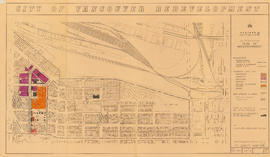
File consists of identification plans and redevelopment plans for project 2.
2245 results with digital objects Show results with digital objects
Part of City of Vancouver fonds
File consists of identification plans and redevelopment plans for project 2.
Vancouver Cityscapes - Downtown, Fairview, Mount Pleasant
Part of City of Vancouver fonds
Item is a set of negatives of cityscape photographs taken mostly from the upper floors of the Plaza 500 Hotel & Convention Centre at 500 W. West 12th Avenue, at the intersection of West 12th Avenue and Cambie Street, looking north. The subject material of the photographs is predominantly downtown Vancouver, the North Shore Mountains, False Creek, and the Fairview and Mount Pleasant neighbourhoods. This set contains the raw photographs from the roll the photographer shot in their original order. The associated contact sheet has selection marks for frames 16, 21, 23, and 25.
Part of City of Vancouver fonds
Item is a map showing boundaries of redevelopment and clearance areas, proposed land use, new streets and lanes, sites not to be acquired, and buildings to be retained in project 2. Map has been annotated with colour indicating land use and a proposed widening of Scotia Street. Base map shows building outlines and topographic contour lines, and covers the area bounded by Main Street, Clark Drive, Terminal Avenue, and Broadway

City of Vancouver redevelopment : project 2, area "H" and part of "B" : identification plan
Part of City of Vancouver fonds
Item is a map showing boundaries of clearance areas and ownership of property included in the acquisition program. Map has been annotated to show a possible amendment to the clearance area boundaries and a proposed widening of Scotia Street. Base map shows building outlines and topographic contour lines, and covers the area bounded by Main Street, Clark Drive, Terminal Avenue, and Broadway

Urban renewal scheme 3 : Mt. Pleasant 2 : apartment development
Part of City of Vancouver fonds
Item is a map annotated to show dates of construction of apartment buildings in the area bounded by Scotia Street, Clark Drive, Great Northern Way, and Broadway. Base map shows streets, building outlines, and topographical contour lines.

Urban renewal scheme 3 : Mt. Pleasant 2 : existing land use
Part of City of Vancouver fonds
Item is a map annotated to show types of land use in the area bounded by Scotia Street, Clark Drive, Great Northern Way, and Broadway. Base map shows streets, building outlines, and topographical contour lines.

Urban renewal scheme 3 : Mt. Pleasant 2 : conditions of residential building
Part of City of Vancouver fonds
Item is a map annotated to show condition of residential buildings in the area bounded by Scotia Street, Clark Drive, Great Northern Way, and Broadway. Base map shows streets, building outlines, and topographical contour lines.

Urban renewal scheme 3 : Mt. Pleasant 2 : conditions of non-residential building
Part of City of Vancouver fonds
Item is a map annotated to show condition of non-residential buildings in the area bounded by Scotia Street, Clark Drive, Great Northern Way, and Broadway. Base map shows streets, building outlines, and topographical contour lines.

Part of City of Vancouver fonds
Item is a map annotated to show the boundaries of Project no. 2 areas 8 and 9. Area 8 corresponds roughly to the area bounded by Scotia Street, Brunswick Street, 2nd Avenue, and 8th Avenue. Area 9 corresponds roughly to the area bounded by Guelph Street, Fraser Street, 5th Avenue, and 7th Avenue. Base map is a reproduction of an aerial photograph showing the area bounded by Main Street, Clark Drive, Terminal Avenue, and Broadway.

Vancouver City Hall from the southwest
Part of City of Vancouver fonds

Proposed convenience at Kingsway & Main St.
Part of City of Vancouver fonds
Item is an architectural drawing of an underground public toilet facility. Drawing includes pans and cross-sections.
Vancouver (B.C.). Engineer's Office

Public Convenience to be erected at Kingsway & Broadway
Part of City of Vancouver fonds
Item is an architectural drawings depicting a design for proposed public toilets. The drawing includes a floor plan, multiple exterior elevations, and the site plan.
Vancouver (B.C.). Building Department

Project 2, area "h" and part of "b" : condition of buildings
Part of City of Vancouver fonds
Item is a map showing the condition of buildings (ranging from very good to very poor), the boundaries of redevelopment for areas "b" and "h" and the boundaries of project clearance for areas 8 and 9 for redevelopment proct 2.

Project 2, area "h" and part of "b" : pavements, curbs and sidewalks
Part of City of Vancouver fonds
Item is a map showing the types of pavement, the curbs and gutters, the sidewalks, the boundaries of redevelopment for areas "b" and "h" and the boundaries of project clearance for areas 8 and 9 for redevelopment project 2.

Project 2, area "h" and part of "b" : existing utilities, water and sewer
Part of City of Vancouver fonds
Item is a map showing the water lines, the sewer lines, the direction of sewer flow, the boundaries of redevelopment for areas "b" and "h" and the boundaries of project clearance for areas 8 and 9 in redevelopment project 2.

Project 2, area "h" and part of "b" : existing gas, electricity and telephone
Part of City of Vancouver fonds
Item is a map showing the gas lines, the electricity lines, the telephone lines, the boundaries of redevelopment for areas "b" and "h" and the boundaries of project clearance for areas 8 and 9 in redevelopment project 2.

Project 2, area "h" and part of "b" : plan of redevelopment
Part of City of Vancouver fonds
Item is a map showing boundaries of redevelopment areas "b" and "h", boundaries of project 2 clearance for areas 8 and 9, in project 2, proposed land use, new streets and lanes, sites in project 2 not to be acquired and buildings in project 2 to be retained.

Project 2, area "h" and part of "b" : condition of buildings
Part of City of Vancouver fonds
Item is a map showing the conditions of buildings (ranging from very good to very poor) in area "a" and part of area "b" in project 2. The map has been annotated to highlite part of the boundary around sub-area 9, as well as the southern portion of the sub-area. The significance of these annotations is not known.
Part of City of Vancouver fonds

Part of City of Vancouver fonds

Part of City of Vancouver fonds
Part of City of Vancouver fonds

Part of City of Vancouver fonds

Part of City of Vancouver fonds
Part of City of Vancouver fonds
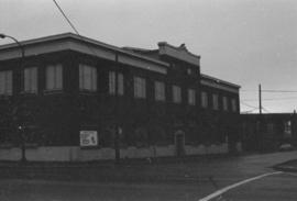
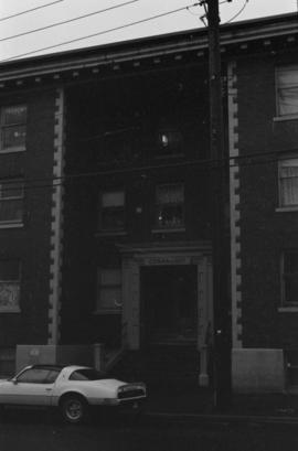
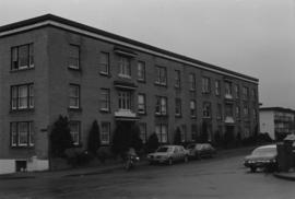
Item is a photograph showing Connaught Apartments.
Part of City of Vancouver fonds
Item is a photograph showing Connaught Apartments.
Part of City of Vancouver fonds

Part of City of Vancouver fonds

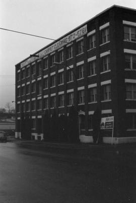
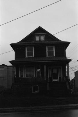
2404 Carolina Street, 2420 Carolina Street, 2422 Carolina Street
Part of City of Vancouver fonds

2404 Carolina Street, 2420 Carolina Street, 2422 Carolina Street
Part of City of Vancouver fonds

Part of City of Vancouver fonds

Part of City of Vancouver fonds

Part of City of Vancouver fonds
Part of City of Vancouver fonds

Part of City of Vancouver fonds

Part of City of Vancouver fonds
Part of City of Vancouver fonds

Part of City of Vancouver fonds
Part of City of Vancouver fonds

Part of City of Vancouver fonds

Part of City of Vancouver fonds

Part of City of Vancouver fonds

Part of City of Vancouver fonds
Part of City of Vancouver fonds

Part of City of Vancouver fonds

Part of City of Vancouver fonds

Part of City of Vancouver fonds

Part of City of Vancouver fonds

Part of City of Vancouver fonds
Part of City of Vancouver fonds