
Capilano and Seymour water sheds
- COV-S371-: MAP 963
- Item
- Jul. 9, 1907
Part of City of Vancouver fonds
Item is a map showing Capilano and Seymour water sheds, reservoirs, pipelines, lot numbers and major roads in the area from Howe Sound to Port Moody and Britannia to Delta. The item includes information about the drainage area, annual precipitation and annual runoff associated with the Capilano and Seymour water sheds.
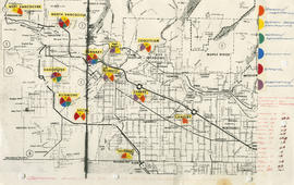


![Vancouver's high-tech industry location map plus G.V.R.D. [Greater Vancouver Regional District] d...](/uploads/r/null/2/b/7/2b7c912f51dd7827d1a0ac60042357a631d2c8fdc3487bc37f286d2945c4ea4c/7a17e6a4-d593-45c5-9625-f03c471efb68-LEG1362_142.jpg)