- COV-S597-F1-: 2019-102.21
- Item
- June 3, 1973
Part of City of Vancouver fonds
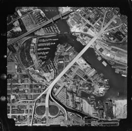
Item is a photograph showing an aerial view from Oak Street to Pine Street, West 6th Avenue, and the north side of False Creek. Includes Granville Street Bridge, Granville Island and the Burrard Street Bridge.


![[Aerial view of lumber yard fire on south shore of False Creek]](/uploads/r/null/3/2/0/3208cbc9d06338a92738b56e1cb989d6c70179caf44b699eb76f28dadbba5a99/0c03d83a-377f-47eb-bbde-90519d0ddcea-CVA354-411_142.jpg)


![False Creek development : san [sanitary] sewers tentative layout](/uploads/r/null/c/a/ca111eaa497f59a66ecdad4c91bfb2238f21efb21b91a1172f460ef16667055f/4da08847-7457-4d4c-8938-e4c6c1dc50c3-MAP692_142.jpg)


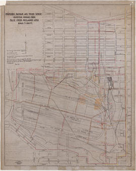
![Plan shewing location of sewers on C.P.Rly. [Canadian Pacific Railway] industrial sites](/uploads/r/null/7/6/1/7619e437193646086fba2c0b959aeb02c1226500076d36df8da8fa5f9e9388e9/b1d0ba23-309d-48e1-a012-2b2eb18a2ff8-MAP738_142.jpg)