
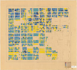
Point Grey section C supplementary information
- COV-S167---: LEG1153.456-: LEG1153.456.049
- Part
- [1946?]
Part of City of Vancouver fonds
Part is a sheet showing assessment and other information relevant to Point Grey section C.
435 results with digital objects Show results with digital objects
Point Grey section C supplementary information
Part of City of Vancouver fonds
Part is a sheet showing assessment and other information relevant to Point Grey section C.

Map of Vancouver, British Columbia : street index
Part of City of Vancouver fonds
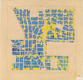
![Government precinct : property ownership and land use [verso]](/uploads/r/null/8/4/e/84e50f799a71410a2996d142e70d69b0501bed32cab066d2243f6ea274574ba6/c904bd24-bb46-4ce9-a065-ceb00e305b93-LEG1200_142.jpg)
Government precinct : property ownership and land use [verso]
Part of City of Vancouver fonds
Map verso showing notes regarding consolidation of schools and zoning.

Marpole : building conditions : legend
Part of City of Vancouver fonds
Item is the legend accompanying LEG1209.1.1.

Marpole : building value per square foot of land : legend
Part of City of Vancouver fonds

Marpole : property ownership : legend
Part of City of Vancouver fonds

Marpole : land value per square foot : increments of $1.50 : legend
Part of City of Vancouver fonds

Marpole : land value per square foot : increments of $0.50 : legend
Part of City of Vancouver fonds
![[Kaslo Street to Trinity Street to Boundary Road to First Avenue]](/uploads/r/null/b/0/9/b09112bbe155335a6a296effdb3280255f5f9de08dd589b23b139a793635b755/a90ccb52-3365-44a6-a8d1-93950b140131-LEG1319_142.jpg)
[Kaslo Street to Trinity Street to Boundary Road to First Avenue]
Part of City of Vancouver fonds
![[Slocan Street to Fourth Avenue to Boundary Road to Twenty-ninth Avenue]](/uploads/r/null/f/f/6/ff6422b668c4a09cb5864577784277126e4adf04ac31e870bd0d03d4e24f0937/a0c6e9dc-b9fd-4037-a021-b55ee9367048-LEG1319_142.jpg)
[Slocan Street to Fourth Avenue to Boundary Road to Twenty-ninth Avenue]
Part of City of Vancouver fonds
![[Vivian Street to Forty-fourth Avenue to Tyne Street to Sixtieth Avenue]](/uploads/r/null/d/e/c/dece1957f510b445c0e5b511a72c5e5348c0f9659ed676dc20ab74078d175201/df782502-b9f4-4c06-83e7-22b355f262e7-LEG1319_142.jpg)
[Vivian Street to Forty-fourth Avenue to Tyne Street to Sixtieth Avenue]
Part of City of Vancouver fonds
![[Churchill Street to Moscrop Street to Wilbers Street to Forty-seventh Avenue]](/uploads/r/null/a/3/7/a3790ded1c589b3e89469ca77d0eecb9f141f77f316931e61cd18566b7c7a7c3/a6d371ab-8d26-4158-9ca2-970901584fa0-LEG1319_142.jpg)
[Churchill Street to Moscrop Street to Wilbers Street to Forty-seventh Avenue]
Part of City of Vancouver fonds
![[Gladstone Street to Brock Street to Churchill Street to Forty-seventh Avenue]](/uploads/r/null/6/1/2/612a09975d93cdac127fd9b7667a9383c2af36575c4ab2826e04617dd721d8a4/7f8cf05c-4144-437d-a11c-1eafd8aa2dba-LEG1319_142.jpg)
[Gladstone Street to Brock Street to Churchill Street to Forty-seventh Avenue]
Part of City of Vancouver fonds
![[Commercial Street to Forty-fourth Avenue to Vivian Street to Sixtieth Avenue]](/uploads/r/null/8/3/d/83dd48a91220822314e8c9bf1fd5abe4ef9f6369258c119dafa6305074d96ba6/472b16c3-50d8-41ab-b8be-9244d0a70a39-LEG1319_142.jpg)
[Commercial Street to Forty-fourth Avenue to Vivian Street to Sixtieth Avenue]
Part of City of Vancouver fonds
![[Commercial Drive to Fourth Avenue to Kaslo Street to Twenty-eighth Avenue]](/uploads/r/null/a/c/2/ac25b16539dce3ea55f30744d6e321ec2deb034e82725e48dc923f52acd69c21/ad072e55-b44c-4d90-8846-908a745039f4-LEG1319_142.jpg)
[Commercial Drive to Fourth Avenue to Kaslo Street to Twenty-eighth Avenue]
Part of City of Vancouver fonds
![[Ross Street to Thirty-first Avenue to Gladstone Street to Forty-seventh Avenue]](/uploads/r/null/8/8/5/885ccc90b7ed7a351394ccd64b1aa3a3da983d02c457529aa1b8324f7b8cc988/55207288-6c59-4044-a5cc-b649e7923463-LEG1319_142.jpg)
[Ross Street to Thirty-first Avenue to Gladstone Street to Forty-seventh Avenue]
Part of City of Vancouver fonds
![[Knight Street to Trout Lake to Nanaimo Street to Thirty-third Avenue]](/uploads/r/null/7/b/e/7beee0dac7d59c0f3063742bba544da3c284409b5b4184e97e6017183e18224b/5359e31e-ecae-45d5-83ba-377893d0e0d4-LEG1319_142.jpg)
[Knight Street to Trout Lake to Nanaimo Street to Thirty-third Avenue]
Part of City of Vancouver fonds
![[Cotton Drive to Yale Street to Slocan Street to First Avenue]](/uploads/r/null/4/8/1/48136fff1b3d09da80675b4d7cc920c218b9acc097e5e4f51cae5a353b9ecefb/6ffd2d57-7e0b-4c4c-9cad-58887a40af41-LEG1319_142.jpg)
[Cotton Drive to Yale Street to Slocan Street to First Avenue]
Part of City of Vancouver fonds
![[George Street to Second Avenue to Commercial Drive to Fifteenth Avenue]](/uploads/r/null/5/8/d/58d4b2e420ee8607a5b3123eba628cda7ee4c3ed8c09956903ffa061c00f9445/4f33d656-be38-48fd-8e52-f786bbb4532a-LEG1319_142.jpg)
[George Street to Second Avenue to Commercial Drive to Fifteenth Avenue]
Part of City of Vancouver fonds
![[George Street to Sixteenth Avenue to Knight Street to Thirty-third Avenue]](/uploads/r/null/e/5/f/e5fe5d72457a39b0c33fff58355c51315b1389140c812df89a1c4e621713f395/71b2a830-b72f-4735-9e6a-d21555bba48d-LEG1319_142.jpg)
[George Street to Sixteenth Avenue to Knight Street to Thirty-third Avenue]
Part of City of Vancouver fonds
![[Dunlevy Avenue to Railway Street to Cotton Drive to Eighth Avenue]](/uploads/r/null/0/1/8/01874441de72d8765481c41a4eb2c613978c6670d7ad028fd4f95b57519e9604/16fdf470-8f9c-4df1-9434-d1bf742cb466-LEG1319_142.jpg)
[Dunlevy Avenue to Railway Street to Cotton Drive to Eighth Avenue]
Part of City of Vancouver fonds
![[Manitoba Street to Forty-seventh Avenue to Chester Street to Sixty-fifth Avenue]](/uploads/r/null/3/8/4/384c7eff34eff09b5b8663d127fccbd76dbd508318fa7d750a1f16e4d478b6e2/6a5c4e63-0d24-48e2-bd23-ba59cb975ce7-LEG1319_142.jpg)
[Manitoba Street to Forty-seventh Avenue to Chester Street to Sixty-fifth Avenue]
Part of City of Vancouver fonds
![[Manitoba Street to Twenty-ninth Avenue to Prince Edward Street to Forty-fifth Avenue]](/uploads/r/null/e/c/c/eccd7c98cf994d6fa60776336001520fc0e92eae9db6c22c4f8f921c1b850838/c1b1b042-4612-45fa-b94e-60294c07f21d-LEG1319_142.jpg)
[Manitoba Street to Twenty-ninth Avenue to Prince Edward Street to Forty-fifth Avenue]
Part of City of Vancouver fonds
![[Walden Street to Thirtieth Avenue to Sherbrooke Street to Forty-sixth Avenue]](/uploads/r/null/d/d/6/dd6538c83ad61f3df408c797e0b38b7a1eb50b2e0a652180035f09f4fc8d0b17/455eb296-f3f3-4cf0-8b82-54d7c8b750ee-LEG1319_142.jpg)
[Walden Street to Thirtieth Avenue to Sherbrooke Street to Forty-sixth Avenue]
Part of City of Vancouver fonds
![[Prince Albert Street to Forty-ninth Avenue to Argyle Street to Sixty-fourth Avenue]](/uploads/r/null/6/7/6/6766abcf01a4c0fe16056476a6632463400e119ba458980a80f25c69ca3da41c/8f04d68d-98f1-4cbe-8480-156f46d08547-LEG1319_142.jpg)
[Prince Albert Street to Forty-ninth Avenue to Argyle Street to Sixty-fourth Avenue]
Part of City of Vancouver fonds
![[Connaught Bridge to Alexander Street to Jackson Avenue to Broadway]](/uploads/r/null/f/1/9/f198ee14ec9185cae73d8569b9fb8d14c0e7f5b24a9c1114855363ea78ffc9ee/ddc95d79-b59a-4881-9534-516fd1067065-LEG1319_142.jpg)
[Connaught Bridge to Alexander Street to Jackson Avenue to Broadway]
Part of City of Vancouver fonds
![[Crown Street to Seventeenth Avenue to Trafalgar Street to Forty-third Street]](/uploads/r/null/1/d/4/1d4c7c46551c019eb14590da1b00e99d6f8542f8d08642ef62441e36f7dfe0d6/05244e73-52b7-4d76-825d-b39814ad4f09-LEG1319_142.jpg)
[Crown Street to Seventeenth Avenue to Trafalgar Street to Forty-third Street]
Part of City of Vancouver fonds
![[Cypress Street to Fifty-second Avenue to Heather Street to Fraser River]](/uploads/r/null/3/7/9/379c8d11cee9c8fd93103115fad5bc69a9210ec3871a9e82922f7c17c3e13d23/1d9d6d6d-2574-4222-aaa7-b3dbe947572c-LEG1319_142.jpg)
[Cypress Street to Fifty-second Avenue to Heather Street to Fraser River]
Part of City of Vancouver fonds
![[Balaclava Street to Thirty-sixth Street to Angus Street to Marine Drive Golf Club]](/uploads/r/null/4/d/7/4d70003099feb12da143db0fe197b8fffe37d5976b1e07ebede05a79062f68f6/50600777-af8a-43b7-a99d-807035e020a5-LEG1319_142.jpg)
[Balaclava Street to Thirty-sixth Street to Angus Street to Marine Drive Golf Club]
Part of City of Vancouver fonds
![[Collingwood Street to Point Grey Road to Balsam Street to Sixteenth Avenue]](/uploads/r/null/5/a/2/5a2869c476ef902eb9a84bae1529ef7b9e94792656c84c66670aef057dc502d5/6054184b-e9a6-4eae-abbd-1732c5468bd6-LEG1319_142.jpg)
[Collingwood Street to Point Grey Road to Balsam Street to Sixteenth Avenue]
Part of City of Vancouver fonds
![Age of buildings : Slocan Street to Boundary Road and Wall Street/East Street [Edinburgh Street] ...](/uploads/r/null/e/9/2/e921e2151aed2f9a2fd506bbc7e781632de17633f5f2f1a410764a15e68501b4/01454f17-8dfb-417d-9fd9-0093f19fcd56-LEG1221_142.jpg)
Part of City of Vancouver fonds
Age of buildings : Knight Street to Elliott Street and 53rd Avenue to Kent Avenue
Part of City of Vancouver fonds
Age of buildings : Knight Street to Wales Street/Vivian Street and 37th Avenue to 53rd Avenue
Part of City of Vancouver fonds

Age of buildings : Nanaimo Street to Jellicoe Street and S.E. Marine Drive to Kent Avenue
Part of City of Vancouver fonds
Annotations show date of construction of buildings for the area bounded by Nanaimo Street, Jellicoe Street, S.E. Marine Drive, and Kent Avenue. Base map shows the area bounded by Knight Street, Elliott Street, East 61st Avenue, and the North Arm of the Fraser River.

Age of buildings : Main Street to Clark Drive and Prior Street/Venables Street to Broadway
Part of City of Vancouver fonds
Sheet is annotated to show the boundary of Area 'H' for the Vancouver Redevelopment Study.

Age of buildings : Jellicoe Street to Boundary Road and S.E. Marine Drive to Kent Avenue
Part of City of Vancouver fonds
Annotations show date of construction of buildings for the area bounded by Jellicoe Street, Boundary Road, S.E. Marine Drive, and Kent Avenue. Base map shows the area bounded by Jellicoe Street/Fraserview Golf Course, Boundary Road, 61st Avenue, and the North Arm of the Fraser River.

Age of buildings : Main Street to Knight Street and King Edward Avenue to 41st Avenue
Part of City of Vancouver fonds
Age of buildings : Quebec Street to Knight Street and 41st Avenue to 57th Avenue
Part of City of Vancouver fonds

Age of buildings : Main Street to Clark Drive/Knight Street and Broadway to King Edward Avenue
Part of City of Vancouver fonds

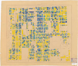
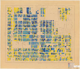
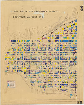
1954 : Age of buildings : Maps 20 and 21 : Downtown and West End
Part of City of Vancouver fonds
Sheet shows date of construction of buildings for the area bounded by Burrard Street, Main Street, Water Street, and the north shore of False Creek. A dotted line runs along a portion of the map, but the significance of the line is unknown.

Age of buildings : Main Street to Knight Street and 57th Avenue to Kent Avenue
Part of City of Vancouver fonds
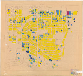
1954 : Age of buildings : Maps 20 and 21 : Downtown and West End
Part of City of Vancouver fonds
Sheet shows date of construction of buildings for the area bounded by Beach Avenue, Hastings Street, Lagoon Drive, and Burrard Street. A dotted line runs along a portion of the map, but the significance of the line is unknown. An annotation at the right edge of the map reads: "other half of "Age of buildings" map."
Age of buildings : Slocan Street to Boundary Road and Pender Street to 5th Avenue
Part of City of Vancouver fonds

Age of buildings : Oak Street to Main Street and Broadway to King Edward Avenue
Part of City of Vancouver fonds

Age of buildings : Oak Street to Quebec Street and 41st Avenue to 57th Avenue
Part of City of Vancouver fonds

Age of buildings : Fremlin Street to Main Street and 57th Avenue to Kent Avenue
Part of City of Vancouver fonds

Age of buildings : Arbutus Street to Oak Street and Odgen Avenue to Broadway
Part of City of Vancouver fonds
Age of buildings : Arbutus Street to Oak Street and King Edward Avenue to 41st Avenue
Part of City of Vancouver fonds

Age of buildings : Arbutus Street to Oak Street and Broadway to King Edward Avenue
Part of City of Vancouver fonds

Age of buildings : Maple Street to Oak Street and 41st Avenue to 57th Avenue
Part of City of Vancouver fonds