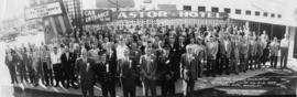
B.C. Fire Chiefs Association 28th Annual Fire College Aug. 18-21, 1959 - Astor Hotel, Burnaby, B.C.
- COV-S280-: CVA 354-436
- Item
- Aug. 1959
Part of City of Vancouver fonds
Panoramic group portrait
37 results with digital objects Show results with digital objects
B.C. Fire Chiefs Association 28th Annual Fire College Aug. 18-21, 1959 - Astor Hotel, Burnaby, B.C.
Part of City of Vancouver fonds
Panoramic group portrait
![Boundary [Road] and 1st [Avenue intersection, 1 of 4]](/uploads/r/null/9/6/9/9695bcecd4922866e0d049bef69cec7da9d5a1e7f2c53aa08f694a933c84d0c0/1055bd04-2c1a-4115-a1d3-63ff237ee0bd-2019-103.0735_142.jpg)
Boundary [Road] and 1st [Avenue intersection, 1 of 4]
Part of City of Vancouver fonds
![Boundary [Road] and 1st [Avenue intersection, 2 of 4]](/uploads/r/null/5/5/0/5501dd5bf9e63254ec85ca5fe31e7dcd6e8eef7ffedfbf4b241ae92633ab02e1/2e4b9431-8b6b-48f9-b55c-1dba477c3b81-2019-103.0736_142.jpg)
Boundary [Road] and 1st [Avenue intersection, 2 of 4]
Part of City of Vancouver fonds
![Boundary [Road] and 1st [Avenue intersection, 3 of 4]](/uploads/r/null/0/e/b/0eb84d4df0834828fffd15aa8c90e29ae98e8d7040fc46a568105f72be5ef66c/02113de5-d2cd-4e28-bbe6-58c8689f1c03-2019-103.0737_142.jpg)
Boundary [Road] and 1st [Avenue intersection, 3 of 4]
Part of City of Vancouver fonds
![Boundary [Road] and 1st [Avenue intersection, 4 of 4]](/uploads/r/null/9/2/8/92860e1f6bca8c02e34cf69a5e6285926581ca681f19103891d5299f5a97d941/d697dc98-c7d1-44dc-bbec-832c4d835e5a-2019-103.0738_142.jpg)
Boundary [Road] and 1st [Avenue intersection, 4 of 4]
Part of City of Vancouver fonds
![Boundary [Road] and 1st [Avenue traffic controller]](/uploads/r/null/c/d/e/cde43ca550dbf98e28432d50cba233198ea385d60b8b6e2f33081539d0c85382/fdb4b9cd-6f57-4f47-a2da-edfbe6dee61e-2019-103.0739_142.jpg)
Boundary [Road] and 1st [Avenue traffic controller]
Part of City of Vancouver fonds
![Boundary [Road] and Canada Way [intersection, 1 of 4]](/uploads/r/null/7/6/7/7675e158669e68f36e99466e129db3b730001dd9ce153821f1981ee73233c0cb/4a1d7b7a-83d7-4658-ac97-3e9d7baad724-2019-103.0715_142.jpg)
Boundary [Road] and Canada Way [intersection, 1 of 4]
Part of City of Vancouver fonds
![Boundary [Road] and Canada Way [intersection, 2 of 4]](/uploads/r/null/8/6/9/869760b38cac4f0279f5b6f2950539b0734ad08bf3b4a1c4581f3f3785be9ac2/d4b59d88-4f2f-451e-a320-0280a4b2ab9c-2019-103.0716_142.jpg)
Boundary [Road] and Canada Way [intersection, 2 of 4]
Part of City of Vancouver fonds
![Boundary [Road] and Canada Way [intersection, 3 of 4]](/uploads/r/null/3/a/4/3a441294f6cab41ff91a08e5801054950dbad3193c81c4c85c42e2daf9b16972/1979c5c9-fb11-4c4a-8232-0848632ddac5-2019-103.0717_142.jpg)
Boundary [Road] and Canada Way [intersection, 3 of 4]
Part of City of Vancouver fonds
![Boundary [Road] and Canada Way [intersection, 4 of 4]](/uploads/r/null/b/c/4/bc43d54bed614afef2be4c9febd5f50b3ce16d5b229b53160db5e7887f126567/3fbfd6d3-6cbc-46b2-ab18-fc032a74bd8b-2019-103.0719_142.jpg)
Boundary [Road] and Canada Way [intersection, 4 of 4]
Part of City of Vancouver fonds
![Boundary [Road] and Canada Way [traffic controller]](/uploads/r/null/a/5/e/a5e0e26be1eaf3143be5851b227bd94a85877fd76c33c27b8137d4ad583c8a8b/c680cfc2-a620-4c50-ba85-cad52884a19f-2019-103.0718_142.jpg)
Boundary [Road] and Canada Way [traffic controller]
Part of City of Vancouver fonds
![Boundary [Road] and Grandview [Highway intersection, 1 of 4]](/uploads/r/null/e/6/9/e69256cb356f6c4c26b74977d6af9544d409579d744b228bcf65f9952220281c/814b74d6-d6b8-435e-bbe9-2d1be85a9c3b-2019-103.0720_142.jpg)
Boundary [Road] and Grandview [Highway intersection, 1 of 4]
Part of City of Vancouver fonds
![Boundary [Road] and Grandview [Highway intersection, 2 of 4]](/uploads/r/null/f/4/d/f4d5db90202b70d2c82b1fa18dffe58db3006c8a6dd9066283bae2fcbe5e486e/bcd557af-e000-48fd-8538-74159a983f92-2019-103.0721_142.jpg)
Boundary [Road] and Grandview [Highway intersection, 2 of 4]
Part of City of Vancouver fonds
![Boundary [Road] and Grandview [Highway intersection, 3 of 4]](/uploads/r/null/9/8/8/988a1cd8c44a00df45c46267bcd28b8634c806ffcfe83929f11809b4e97cf9c0/993eed54-87f0-4d72-b7f5-5cc8b81dd598-2019-103.0722_142.jpg)
Boundary [Road] and Grandview [Highway intersection, 3 of 4]
Part of City of Vancouver fonds
![Boundary [Road] and Grandview [Highway intersection, 4 of 4]](/uploads/r/null/8/d/9/8d98e9ba9e29cc975bc40edc8d93b002b7318474ed1724b441467364400b75c4/d9757116-da4c-4d79-809a-1ace76ed5df0-2019-103.0723_142.jpg)
Boundary [Road] and Grandview [Highway intersection, 4 of 4]
Part of City of Vancouver fonds
![Boundary [Road] and Grandview [Highway traffic controller]](/uploads/r/null/1/e/9/1e9190e49ced6d16a147d6d10fb2a31463466cd09355c0a63dc8a67f5a7bbde9/4efd17d0-6828-4b07-8eb2-e6b3aa1352dd-2019-103.0724_142.jpg)
Boundary [Road] and Grandview [Highway traffic controller]
Part of City of Vancouver fonds
![Boundary [Road] and Hastings [Street intersection, 1 of 4]](/uploads/r/null/3/2/e/32e8022712055e15d6a884ce4d3b6bde8c183ce39eaa58dceed794b0c1823b7c/9ba96e1b-7a82-444d-83c1-1e0266075398-2019-103.0740_142.jpg)
Boundary [Road] and Hastings [Street intersection, 1 of 4]
Part of City of Vancouver fonds
![Boundary [Road] and Hastings [Street intersection, 2 of 4]](/uploads/r/null/1/3/7/1372fe5015e011e4c493845130b7a4d8bc11b5ea6cc4dce82dfd76f1e17a0063/e562b602-5f49-4f14-8df8-f4957407027f-2019-103.0741_142.jpg)
Boundary [Road] and Hastings [Street intersection, 2 of 4]
Part of City of Vancouver fonds
![Boundary [Road] and Hastings [Street intersection, 3 of 4]](/uploads/r/null/e/b/7/eb73fcb4a69c9fd0df16c0472a7193c28811af6303f355b164cc419a3ebcea91/6c1547dc-100c-43c4-9b7b-a5f0fd9f0a1f-2019-103.0742_142.jpg)
Boundary [Road] and Hastings [Street intersection, 3 of 4]
Part of City of Vancouver fonds
![Boundary [Road] and Hastings [Street intersection, 4 of 4]](/uploads/r/null/5/0/2/50208124e2583c38e36f5e7d4f3f3b1c34757d9adf4da37f49c5951f79e78b92/452c3a64-3ed0-438d-aff8-c85f22109a0c-2019-103.0743_142.jpg)
Boundary [Road] and Hastings [Street intersection, 4 of 4]
Part of City of Vancouver fonds
![Boundary [Road] and Hastings [Street traffic controller]](/uploads/r/null/3/6/c/36c134da01976a4cf68d2b48f3f5e52e4ddb4413077635146d11ce0b0be3d702/9dcd2a33-d4f4-43d6-95c7-795af1bcf4af-2019-103.0744_142.jpg)
Boundary [Road] and Hastings [Street traffic controller]
Part of City of Vancouver fonds
![Boundary [Road] and Kingsway [intersection, 1 of 4]](/uploads/r/null/0/2/2/02262cc3e7b316bf51bd9656b28f9e089cfdc4b7a99473fd5c08d4c9302d127c/88cc4727-279d-456f-8e3c-7de3be1c913a-2019-103.0700_142.jpg)
Boundary [Road] and Kingsway [intersection, 1 of 4]
Part of City of Vancouver fonds
![Boundary [Road] and Kingsway [intersection, 2 of 4]](/uploads/r/null/6/7/f/67ff18ce27673f4b7eb4c03c47d07d0f749636277aab9a6ea44a07a70fba6571/50d3cce2-aeb2-4e77-9236-573dbea8f887-2019-103.0701_142.jpg)
Boundary [Road] and Kingsway [intersection, 2 of 4]
Part of City of Vancouver fonds
![Boundary [Road] and Kingsway [intersection, 3 of 4]](/uploads/r/null/9/1/3/9137f0ba2a952e0b69a29ed5de592fd78677b7f1bc98c013b37ba8594899de7a/386c0bc0-0496-41c3-9840-17f071993d40-2019-103.0702_142.jpg)
Boundary [Road] and Kingsway [intersection, 3 of 4]
Part of City of Vancouver fonds
![Boundary [Road] and Kingsway [intersection, 4 of 4]](/uploads/r/null/2/4/f/24f3720760cf801eb006ac76bb0cfc7d8fb04ea2f597a081f6be29051b5e369c/5d57d00c-dbbf-4553-8660-bdf6fc54a857-2019-103.0703_142.jpg)
Boundary [Road] and Kingsway [intersection, 4 of 4]
Part of City of Vancouver fonds
![Boundary [Road] and Kingsway [traffic controller]](/uploads/r/null/e/4/6/e46a398613dc48302bdb921895e388fa26f292213254889bef2226ebac2f77c0/9ca9180a-7397-4009-9fc0-fe4e589248a1-2019-103.0704_142.jpg)
Boundary [Road] and Kingsway [traffic controller]
Part of City of Vancouver fonds
![Boundary [Road] and Lougheed [Highway intersection, 1 of 4]](/uploads/r/null/5/2/e/52e18fe991968bc1dfcb36801aada715afbf37e38985d738e597d7124fe49ddf/5ad5714f-054c-4908-aa04-6c53775679b6-2019-103.0725_142.jpg)
Boundary [Road] and Lougheed [Highway intersection, 1 of 4]
Part of City of Vancouver fonds
![Boundary [Road] and Lougheed [Highway intersection, 2 of 4]](/uploads/r/null/7/c/6/7c66798238b311cb7b53060bbcc659a12be9bea585029ab352cc27df7c7477b3/246b25e9-695f-4b02-8e8f-553830210325-2019-103.0726_142.jpg)
Boundary [Road] and Lougheed [Highway intersection, 2 of 4]
Part of City of Vancouver fonds
![Boundary [Road] and Lougheed [Highway intersection, 3 of 4]](/uploads/r/null/f/e/a/fea66ce7f8ba4ceb872c3ac8aa0e193318323b37c5d5c5cfd2ce870221349295/cddb44ab-bdb5-427f-acfc-beed6766b14c-2019-103.0727_142.jpg)
Boundary [Road] and Lougheed [Highway intersection, 3 of 4]
Part of City of Vancouver fonds
![Boundary [Road] and Lougheed [Highway intersection, 4 of 4]](/uploads/r/null/c/4/7/c473bfe8bfcb3d91b70b6e5f55f7c689561ee15f264269fe6ae08857d943361a/971a971f-7dcb-48d7-b294-4c3869ac6f7b-2019-103.0728_142.jpg)
Boundary [Road] and Lougheed [Highway intersection, 4 of 4]
Part of City of Vancouver fonds
![Boundary [Road] and Lougheed [Highway traffic controller]](/uploads/r/null/c/2/5/c257bc2d90a574935880b968cf65718543e8e417527023a84b8faafc744998ca/e1e764a6-7822-42f6-a76e-e341ae5274ad-2019-103.0729_142.jpg)
Boundary [Road] and Lougheed [Highway traffic controller]
Part of City of Vancouver fonds
![Boundary [Road] and Marine Way [intersection, 1 of 4]](/uploads/r/null/0/4/3/0430bf34efbc5a34d0cba81f7dfe3507e63617a9168e105399ac93b3bdcd7530/3af2a02b-db88-44e5-aa32-2c10bf9484a8-2019-103.0695_142.jpg)
Boundary [Road] and Marine Way [intersection, 1 of 4]
Part of City of Vancouver fonds
![Boundary [Road] and Marine Way [intersection, 2 of 4]](/uploads/r/null/c/6/2/c624f5c77f69993fe65c80bd7dc6875f05ba95b11f18c376c1c6cc2bd9c1103a/ef9d4ed8-4708-4c6c-b665-27475a82bdce-2019-103.0696_142.jpg)
Boundary [Road] and Marine Way [intersection, 2 of 4]
Part of City of Vancouver fonds
![Boundary [Road] and Marine Way [intersection, 3 of 4]](/uploads/r/null/1/4/5/145374f880f1305d6c90eeeb05789bcaca34b427ec36b3167ae09d1b41898e4c/897168b6-f26f-4fd0-9ff1-6eabfa2842ff-2019-103.0697_142.jpg)
Boundary [Road] and Marine Way [intersection, 3 of 4]
Part of City of Vancouver fonds
![Boundary [Road] and Marine Way [intersection, 4 of 4]](/uploads/r/null/4/8/e/48e1cf3b9fa9080ee49c00f4c5a5c2e1160a784a886fc0bc51be08d9c0bf4265/769ddfc1-cb8a-4fce-9535-857903f6e5c9-2019-103.0698_142.jpg)
Boundary [Road] and Marine Way [intersection, 4 of 4]
Part of City of Vancouver fonds
![Boundary [Road] and Marine Way [traffic controller]](/uploads/r/null/6/7/8/678879723b742f0884e0383ca3bd2b61bbde7dd840f91c21a1fe752942a9f928/1040b1a8-8d2d-4cd4-b3a2-d76f49af3135-2019-103.0699_142.jpg)
Boundary [Road] and Marine Way [traffic controller]
Part of City of Vancouver fonds
![Schou [Street] and Canada Way [looking] west](/uploads/r/null/8/0/8005aaa4caa8d824bd5cd65ea4fa590aafbb9cdfcfe71df5bacf3ff6d279d6c4/73562fd4-d35a-46f8-8bb5-373e167c3a2d-A42833_142.jpg)
Schou [Street] and Canada Way [looking] west
Part of City of Vancouver fonds