![Demolition of old Vancouver Club building [915 West Hastings Street]](/uploads/r/null/4/c/4ceb1ab87cd0986949e6702721dd65c057e745e4e8e06e473c680ebb4e65ac47/1ca9e134-8fa6-4cf1-89c1-61feed851e6b-A01853_142.jpg)
Demolition of old Vancouver Club building [915 West Hastings Street]
- AM336-S3-2-: CVA 677-66
- Item
- 5 Feb. 1930
Photograph shows partially demolished building, workers, and cars parked in front of the building.
Demolition of old Vancouver Club building [915 West Hastings Street]
Photograph shows partially demolished building, workers, and cars parked in front of the building.
![[View of buildings and businesses in Port Hammond.]](/uploads/r/null/1/8/18b2adea6125e4e8913ec8f094149e1908733cba617f86e73c8683cb4817d283/0cb95f58-85c2-495b-8054-fdcd9d600c85-A03902_142.jpg)
[View of buildings and businesses in Port Hammond.]
[Photograph shows Wilson's Ice Cream Parlor.]
![[View of buildings on] Maple Crescent, Pt. Hammond](/uploads/r/null/7/7/77ca7a140e6443a74e8398b1ea2fb82eed27969545acac7212750ca70e5ac26d/28c94f4b-14b0-40d6-bcc3-aa2a21f1afd2-A03903_142.jpg)
[View of buildings on] Maple Crescent, Pt. Hammond
Photograph shows horses and carriages and an automobile on the street outside the J.M. Dale General Merchandise building and Wilson's Ice Cream Parlor.

Court house, Hotel Vancouver, and Vancouver Block from Robson Street
![Northwest corner of Georgia and Howe Streets [showing Georgia Street extending west]](/uploads/r/null/8/0/80964f60e791333d349135598cbd194a1ac79bc00da2ccb6debd0427ca5bf7fe/b2f30516-09ff-4247-8082-182ec9a584aa-A01863_142.jpg)
Northwest corner of Georgia and Howe Streets [showing Georgia Street extending west]
The photograph shows pedestrians, a horse-drawn carriage, the East Indian Tea Company (801 Georgia Street), Christ Church Cathedral and Stanley Park and the North Shore in the background.
![[View from the Hotel Vancouver]](/uploads/r/null/5/f/5fd30a3fc14063f0dbb640587b3558030cbb3634316d54c57ae1f0125342b807/2e027352-524f-44a4-ad9f-7ddeb3cca11e-A01983_142.jpg)
[View from the Hotel Vancouver]
Photograph shows buildings, streets, and waterfront area.
![[View from the Hotel Vancouver]](/uploads/r/null/6/6/66d9b845ba230d08c348397ab47510a958958265bf3010ba9574b24ecc12435a/163367d2-1d4f-4e47-8c56-d148e70df03d-A01984_142.jpg)
[View from the Hotel Vancouver]
Photograph shows buildings along and between Howe and Granville Streets, as well as the waterfront area.
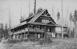
Horticultural Hall, North Vancouver, B.C.
![Vancouver, B.C. - looking north from the World Building [at Pender and Beatty Streets]](/uploads/r/null/b/c/bc3ce0e1c9bcc9b5fc2ca1d261d99e0a48d2a5b14b123f01fc92ec4065227491/70ac4781-f5a4-4e70-9f38-a9e1bb836db9-A01936_142.jpg)
Vancouver, B.C. - looking north from the World Building [at Pender and Beatty Streets]
Photograph shows buildings, with Stanley Park in the distance.

Vancouver, B.C. looking north from the Tower Building

Corner of Robson and Howe Streets, Vancouver, B.C.
![Train [behind Columbia Street]](/uploads/r/null/7/7/7754e57aef040ec3a315841aa703c2e9c9e635aa038009685919d48042b5eb1c/3cbfc973-f427-42c2-bd6e-ef9df0ada309-A02116_142.jpg)
Train [behind Columbia Street]
Photograph shows six men posing at front of train. Various buildings can be seen behind the train, including T. J. Trapp and Company (688 Columbia Street) and Anderson and Lusby (634 Columbia Street).

Hastings Street West, Vancouver, B.C. - Bank of Ottawa building
Photograph shows Hastings Street, looking west.

Vancouver, about end of 1886 (after fire), showing Cordova and Hastings Streets, and the City Wharf
Photograph shows buildings, dirt roads, plank sidewalks, and the waterfront area. Various areas in the waterfront are labelled with letters.
![[Panorama view of Burrard Inlet, from the Hotel Vancouver]](/uploads/r/null/0/7/07d6d50b40dc0e2c000204aa2db07e90af3eaec2d87ebeb52fa15a71dd68d8e3/0a7ae66f-0db2-4fcb-bb32-70f5159c5372-A02098_142.jpg)
[Panorama view of Burrard Inlet, from the Hotel Vancouver]
Photograph shows downtown buildings, part of Stanley Park, the Burrard Inlet, and the North Shore.
![[View of the 100 block Water Street looking west from the corner of Abbott and Water Streets]](/uploads/r/null/f/5/f50931c33ed86a0ebc9af467f775a535d1458153a83d9d215c1c3e6d00511175/7034fccd-af6e-4178-b775-95bd34efe174-A02095_142.jpg)
[View of the 100 block Water Street looking west from the corner of Abbott and Water Streets]
Photograph shows Canadian Fairbanks Co. Ltd. (101 Water Street), Allen's Feed store (113 Water Street) and other buildings in the block.
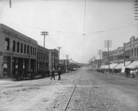
New Westminster, B.C. Columbia Street
Photograph shows streetcar tracks in the middle of the street, and businesses on either side. Also shown are various horse-drawn carts, and two men crossing the street.

Photograph shows docks and boats, commercial and industrial buildings, and houses in the distance.
![[Panorama view of Vancouver looking north from Nelson Street]](/uploads/r/null/a/2/c/a2cbf67d9e217c29ca20d8e07b9e19e016002e1fa58bc96f21141f17b5271c84/52df33e9-d34f-45a7-bef4-bb7a2566c630-CVA677-656_142.jpg)
[Panorama view of Vancouver looking north from Nelson Street]
Prominent buildings in photograph are: Manhattan Apartments (784 Thurlow Street), Marine Building (355 Burrard Street), Hotel Vancouver (900 West Georgia Street), Provincial Court House (750 Hornby Street); Second Hotel Vancouver (Granville Street), Vancouver Block (736 Granville Street), First Baptist Church (969 Burrard Street) and St. Andrew's-Wesley United Church (1012 Nelson Street).
![[North Vancouver from Burrard Inlet]](/uploads/r/null/f/2/f285dd5633144f255b287145d9cec78b096827c3110720acace67fe73e7d654a/b97f757f-39e2-4c8f-9352-a095c360e4fe-A02535_142.jpg)
[North Vancouver from Burrard Inlet]
Photograph shows roads, houses, and other buildings near the North Vancouver waterfront.

Photograph shows various building and streets.
![[Granville Street near Pender Street, looking north, showing sign for Semi-Ready Tailoring]](/uploads/r/null/1/8/18e5f88a77032fa4077010395c66a954f9f6525eeb74e47c363fbc365a76424d/5e0ce98d-ca14-4d39-be49-d7caa1330521-A02360_142.jpg)
[Granville Street near Pender Street, looking north, showing sign for Semi-Ready Tailoring]
A label on the back of the photograph mounting reads: "Granville Street, near Pender. Looking North. A foggy day in the autumn. One auto, tram cars on left hand side, the hand cart, Rand Bros. office, Old Style sign of 'Semi-Ready.' The corner before the Rogers building was built."

Georgia Street at Hornby Street
Photograph shows horse-drawn carriages on street, including one for the Badminton Hotel; Christ Church Cathedral; and a building containing both a grocery store (Kyle Grocery) and a picture framing store (Timms Art Emporium), later the site of the Georgia Medical - Dental building, then Cathedral Place.
![[View along Granville Street looking south from the waterfront]](/uploads/r/null/a/8/a81919f0d7a9cce33aa66dc6d68e3e2c7a877653cc0f6b2951a019cdcd2809cd/bdad4e9c-5832-4ef0-89cb-35d36e7033d5-A02441_142.jpg)
[View along Granville Street looking south from the waterfront]
![[View of corner of Granville and Georgia Streets, from above]](/uploads/r/null/8/4/84d2f043d11bfc49dd8b9e03559d48dc0bdc6f2d9ab77148ca1b47a95e28f436/cbea8557-ae79-4438-846b-11f87fafbc4e-A02458_142.jpg)
[View of corner of Granville and Georgia Streets, from above]
Photograph shows buildings (including the Hudson's Bay Stores building), and Burrard Inlet and waterfront in the distance.
![[Granville Street, south of Pender Street, showing Post Office and Fairfield Building]](/uploads/r/null/8/1/81dce190141bba00d97626774381358d38e1e3ca3353334aae75a20cfd4e7387/ffe943e0-441b-436b-9749-e40895d41027-A02461_142.jpg)
[Granville Street, south of Pender Street, showing Post Office and Fairfield Building]
Photograph shows pedestrians, carriages, streetcars, and buildings.
![[Richards Street at Hastings Street]](/uploads/r/null/a/6/a625bdb513e13c9addbf1738457da7d1cbfdda1bbb3e471952b6bdce2407e2c1/5dca5fa0-479f-486e-bc8e-d0e30abbda91-A02462_142.jpg)
[Richards Street at Hastings Street]
Lettering on the photograph reads: "Hastings at Richards."
![[Hastings and Cambie Streets, showing front steps and lawn of Court House]](/uploads/r/null/b/9/b93c68a3057c6b5105ac2f06e4b4f6e2ca0fc32e13d22069cbf2c572441663ac/96cc76f9-af2f-4c70-a226-7ac80e30fb18-A02463_142.jpg)
[Hastings and Cambie Streets, showing front steps and lawn of Court House]
Photograph also shows other buildings, carriages, and children playing on the Court House lawn.
![[Granville Street at Dunsmuir Street, looking north]](/uploads/r/null/4/d/4d8ade4aead8e8b9f4c50bbe7645952224e0a043c1c842ef8ec8d0205c8bbd7a/2e188148-f1a5-474e-9334-8cf17ccec9bd-A02464_142.jpg)
[Granville Street at Dunsmuir Street, looking north]
Photograph shows pedestrians, cyclists, streetcar, and buildings on the west side of Granville Street.
![[View of the 500 block of Granville Street looking north from Dunsmuir Street]](/uploads/r/null/4/0/4082533bb8e0f02f157a56ac3ccee2c3d50ffe174aab86de21c92ec0a0a4d6b7/d6253402-4698-461d-877f-b3fe516038a3-A02467_142.jpg)
[View of the 500 block of Granville Street looking north from Dunsmuir Street]
Photograph shows a large carriage travelling north in front of the Fee Block and the Bank of Monrteal.
![[Carrall Street at Hastings Street]](/uploads/r/null/9/8/981278cb87faefe9cf15a2ab9b224d1d9c0af207863bc3f7420b781a4bf67835/2ed91238-1352-43af-9544-1fa5a6260908-A02471_142.jpg)
[Carrall Street at Hastings Street]
Photograph shows pedestrians crossing street, and businesses such as the Mint Saloon, and McTaggart and Moscrop Hardware.

Granville Street, south of Dunsmuir Street
Photograph shows pedestrians, carts, streetcars, and buildings, including the site of D. A. Smith Furniture.

Hastings Street between Hamilton and Homer Streets
An accompanying label reads: "Hastings St. between Hamilton and Homer St. This block held its own for a number of years, but the march was always westward. Some of the well known names the businessmen are clearly seen -- Fit-Reform, Thompson Stationery, Buscombe, Clubb and Stewart, King Studio, Moore and Clarke and the Arcade. - Timms Photo."

Hastings Street at Granville Street
Photograph shows pedestrians, streetcars, the Birks Clock, and a banner announcing baseball games.

Photograph shows the Inns of Court Building (423 Hamilton Street at West Hastings) and the Debeck Building (336 West Hastings Street).
![[Granville Street at Pender Street, looking south]](/uploads/r/null/5/5/55e4375e82b626cdb5d0a5f91984336452d695f24c4f2a8c93a2e647db93175a/f7fd2ec3-c4c7-4225-874f-14806667f566-A02483_142.jpg)
[Granville Street at Pender Street, looking south]
Photograph shows streetcars, carriages, pedestrians, and businesses, including McIntyre's Cafe in the Imperial Life building.
![[Granville Street at Pender Street, looking north]](/uploads/r/null/d/a/da006579e867e70cf68a197397fb8645e39dc13d6e03e4a8479e01380c374934/c2540d40-b50a-4dc0-b85f-5dafbf2ec474-A02481_142.jpg)
[Granville Street at Pender Street, looking north]
Photograph shows a streetcar, pedestrians, and various buildings, including the Imperial Life building, and the Post Office and C.P.R. station in the distance.
![[View of downtown Vancouver and waterfront from above, showing Marine Building under construction]](/uploads/r/null/8/6/86680d24afa6725e26cf86f7f036e9815677dd146b76bc60b8f6ca6d82e69d2c/3adf3f30-5dd9-4268-871f-b68de7c89733-A02521_142.jpg)
[View of downtown Vancouver and waterfront from above, showing Marine Building under construction]
Photograph shows buildings, waterfront, and part of Stanley Park, looking north west.
![[View of downtown Vancouver from above], Granville and Dunsmuir Streets](/uploads/r/null/b/4/b4ae75bf13f8332262cc747186aa1f31877d4d2306817e387a6115f2e26fc657/0d0c61e0-2a90-4a04-bba2-1ecd45c35204-A02520_142.jpg)
[View of downtown Vancouver from above], Granville and Dunsmuir Streets
Photograph shows buildings in downtown Vancouver, looking east. Photograph also shows Burrard Inlet and part of the waterfront in the distance.
City Museum and Art Gallery, main floor, looking east, Vancouver, B.C.
Photograph shows an interior view of museum.
![Staircase, from main lobby [Vancouver museum]](/uploads/r/null/7/7/771879c7d0f430e4268b44847421c967365f115a91d0898c1f8f3dcc3c2fe19e/6c88166d-84f4-434a-b782-31dba6cb6219-A02544_142.jpg)
Staircase, from main lobby [Vancouver museum]
![Main staircase, from the first floor [Vancouver museum]](/uploads/r/null/3/6/361151a319c02d64c259b21ee6d9328fc8eeda6c1a8171eaa186f14a91fc385a/1d21ec94-d979-48f4-8d5c-1f719588c917-A02545_142.jpg)
Main staircase, from the first floor [Vancouver museum]
![Main staircase leading to the [Vancouver] museum](/uploads/r/null/d/0/d0a11f719240b5aeee635411bbe779d9db8da86a5fafdd479888f1d2be415d32/a067c803-e0d8-487d-bc57-2e90f7e67fc1-A02542_142.jpg)
Main staircase leading to the [Vancouver] museum
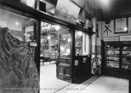
Entrance to City Museum and Art Gallery, Vancouver, B.C.
Photograph shows interior entrance.
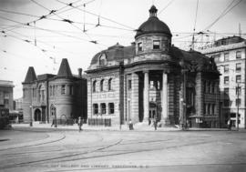
City Museum, Art Gallery and Library, Vancouver, B.C.
Photograph shows Carnegie Building (401 Main St. at Hastings).

City Museum, Art Gallery and Library, Vancouver, B.C.
Photograph shows the front of the Carnegie Building (401 Main St. at Hastings)
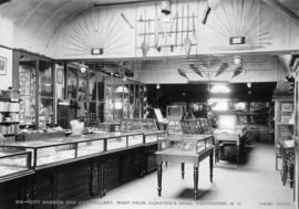
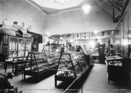
City Museum and Art Gallery, west from curator's desk, Vancouver, B.C.
Photograph shows interior view of museum


Photograph shows pedestrians outside post office at Granville and Pender Streets. Photograph also shows the C.P.R. station in the background.
![New Westminster, B.C. [waterfront area]](/uploads/r/null/3/9/393d0003bd15e184863d0d02d03ffec195e8ac1a4bc8183377847359882b61ca/ec6cf2d6-ec41-40d7-9eda-eec2a58294a1-A02608_142.jpg)
New Westminster, B.C. [waterfront area]
Photograph shows the waterfront area from across the Fraser River. Photograph shows industrial buildings, houses, and some streets.