Map of the world, western continent undiscovered
- AM54-S12-MAP P30
- Item
- [between 1689 and 1700] (copied 194-?)
Part of Major Matthews collection
19141 results with digital objects Show results with digital objects
Map of the world, western continent undiscovered
Part of Major Matthews collection
Map of the world, west coast of Canada still unknown
Part of Major Matthews collection
New England Colonies, 1754, from Gentleman's Magazine
Part of Major Matthews collection
North West Passage, 1592, 1603 Strait of Juan De Fuca
Part of Major Matthews collection
Wolfe, James, photostat of letter written in 1758, Carleton & Vancouver specimens
Part of Major Matthews collection
Part of Major Matthews collection
North West Passage, early map of, 1760, route to Europe
Part of Major Matthews collection
Part of Major Matthews collection
Item consists of a photographic copy of Benjamin West's painting The Death of General Wolfe, presented to J.S. Matthews by Marjorie Wade.

The Russian discoveries from the map published by the Imperial Academy of St. Petersburg
Part of Major Matthews collection
Item is a map showing the locations of Russian exploration discoveries around the Pacific coast, as well as some discoveries by other explorers such as Juan de Fuca and Sir Francis Drake. Area shown includes Russia, China, Japan, Northern Ocean, Pacific Ocean and North America. Includes a explanation of Russian names on the map.

A general chart: exhibiting the discoveries made by Capt. James Cook
Part of Major Matthews collection
Part of Major Matthews collection
British Columbia, 1790, unknown coast of North America, Gentleman's Magazine, 1790
Part of Major Matthews collection
Jose Maria Narvaez, 1791, map Burrard Inlet, Strait of Georgia, Spanish names
Part of Major Matthews collection
Portion of a map of the Straits of Juan de Fuca
Part of Major Matthews collection
Item is a copy of the bottom right-hand portion of a Spanish map of the Straits of Juan de Fuca, republished in North-west America Water Boundary (London, 1873).
Mackenzie, Alexander, 1793, a map of Mackenzie's track from Fort Chipewyan to the Pacific Ocean
Part of Major Matthews collection
Lease agreement and Edinburgh Soldiers' association articles
Part of Major Matthews collection
File consists of two parchments: one is the Articles of the Society of the Edinburgh City Guards, Soldiers, etc. dated 15 Dec. 1794, and an Indenture for a one-year lease between John Siday and William Purchas [?] with William Godfrey and John Stacye, dated 2nd Feb. 1671.
Spanish place names on Pacific Coast, ca. 1794, taken from book
Part of Major Matthews collection
Capt. Geo[rge] Vancouver excerpt of famous letter
Part of Major Matthews collection
Capt. George Vancouver's letter, written from Nootka in 1794
Part of Major Matthews collection
Portion of Galiano's map of the Straits of Juan de Fuca
Part of Major Matthews collection
Item is a copy of the bottom left-hand portion of Galiano's map of the Straits of Juan de Fuca, republished in North-west America Water Boundary (London, 1873).
Map of North America from old book "The Modern Gazetteer," Vol. 1
Part of Major Matthews collection
Map of South America from old book "The Modern Gazetteer," Volume 1
Part of Major Matthews collection
Capt[ain] George Vancouver's letter to James Sykes
Part of Major Matthews collection

A chart showing part of the Coast of N.W. America
Part of Major Matthews collection
Item is a copy of a plate from the atlas of charts of George Vancouver's explorations of the north-west coast of North America (see MAP 595 for originals).
Map of North America, taken from Atlas of the World, 1809
Part of Major Matthews collection
Mouth of Fraser River, 1827, 1860, 1890, 1919, chart showing silting
Part of Major Matthews collection
![[67th South Hampshire Regiment]](/uploads/r/null/1/c/1c093d0d8eccca9b84f28801f319d789a67549e7cefe0ecc8b9918910a0b84d9/573037b2-90a1-4e66-953c-00f693595940-A32352_142.jpg)
[67th South Hampshire Regiment]
Part of Major Matthews collection
Group portrait
![[67th South Hampshire Regiment]](/uploads/r/null/f/f/ffa85189440fd185ed26f7c28279060ea16332c5c9afc0841d7836504e3b5971/9aefc90d-4edd-43d0-a846-2cccc21b605b-A32353_142.jpg)
[67th South Hampshire Regiment]
Part of Major Matthews collection
Group portrait in front of a log building
Part of Major Matthews collection
Item is a portrait of John Matthews, the great-grandfather of Major James Skitt Matthews.
Roos, William
Marriage, written promise of as soon as clergyman can perform the ceremony
Part of Major Matthews collection
Part of Major Matthews collection

Part of Major Matthews collection
![[Major General Rogers]](/uploads/r/null/a/3/a333117c00981139680e76a0e8aedc2cd65e70482f18e1975e8b65a4652cb3bd/f2392132-8a65-4033-985b-cec709296a81-A34506_142.jpg)
Part of Major Matthews collection
Studio portrait

Part of Major Matthews collection
Part of Major Matthews collection
Part of Major Matthews collection
Item is a copy of a letter from Douglas to Yale re: Indian murder
Amor de Cosmos, change of name from Wm. [William] Alex Smith, Feb. 7, 1854, neg. encl.
Part of Major Matthews collection
![[Railway yards] immediately below Keefer's house](/uploads/r/null/c/a/ca56324326d41d166dd0db141089c83221c7869a20d0cab1e7ca7098540254f1/68e97b63-8e1b-47cf-b430-980eaeb0e409-A25449_142.jpg)
[Railway yards] immediately below Keefer's house
Part of Major Matthews collection
Correspondence regarding the discovery of coal at Coal Harbour
Part of Major Matthews collection
File consists of photostat copies of a letter from Charles B. Wood to George Henry Richard (draft and final) and a letter from George Henry Richard to James Douglas (draft and final).

Part of Major Matthews collection
Item is a copy of a portion of a manuscript map of Burrard Inlet, created during the H.M.S. Plumper survey of the area. Sheet shows the eastern portion of the Inlet, including the southern portion of the North Arm.
United Kingdom. Admiralty
Rev. W. Cricker's drawing of the Fraser River, Lady Franklin and the rock named after her
Part of Major Matthews collection
Fraser River and Burrard Inlet
Part of Major Matthews collection
![[Louis Oppenheimer]](/uploads/r/null/3/4/3482369edf79bbdb30229039b17fb9847e9fcd8bd800d260ad552bf54e4dd8b1/ad7c41a9-e7b4-466b-90b2-77f7d55a689a-A35822_142.jpg)
Part of Major Matthews collection
Studio portrait
![[Mrs. Benjamin Springer (nee Frances Nias)]](/uploads/r/null/c/a/ca224d65615780f4d8db5b187e45a1ca4c1fe491e81acf2c4b841e6883315c99/7464c91c-c001-4588-bfc5-f425b0f080dc-A34654_142.jpg)
[Mrs. Benjamin Springer (nee Frances Nias)]
Part of Major Matthews collection
Head and shoulders portrait

Map showing the line of boundary between the United States & British possessions
Part of Major Matthews collection
Four cross sections, mainland to Vancouver Island
Part of Major Matthews collection
Item is a sheet depicting four cross sections of surface and underwater topography between the North American continent and Vancouver Island at north latitudes of 49 degrees, 48 degrees 45 minutes, 48 degrees 35 minutes, and 48 degrees 25 minutes. Depths

Map of Esquimalt, showing location of Royal Hospital
Part of Major Matthews collection
Item is a photostat copy of an 1869 tracing of a map created during or after the survey of George Henry Richards, R.N. of H.M.S. Hecate.
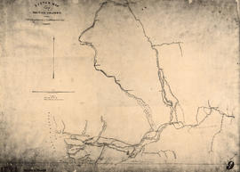
Sketch map of part of British Columbia showing trails and routes of communication
Part of Major Matthews collection
Item is a photostatic copy of a manuscript map showing trails and routes of communication in a portion of British Columbia from the Canada-U.S. border in the south to Seaton Lake in the north, and from the coast to Vermillion in the east. The section of coastline extends from Semiahmoo Bay in the south to Point Atkinson in the north. Map shows the location of mule trails and wagon roads, and includes a trail in progress from New Westminster to Burrard Inlet (North Road), trails from Whatcom to Hope and Semiahmoo to Derby, the Hudsons Bay Brigade Trail, Douglas Road, a trail proposed by Colonel Moody from New Westminster to Fort Hope, and the Dewdney Trail. Included with the map is a 1949 letter from Major Matthews, City Archivist, to J.M. Pearce in which Matthews describes the map, and a 1952 enquiry from L.B. [Housler] for a map showing the Dewdney Trail.
![Country lands, New Westminster District [D.L. 185]](/uploads/r/null/2/f/f/2ff00fcb19a3dd23ff02f3355264a2fef808da9c2362a01bc084c87c334bbb27/0143c5f1-96bf-4733-b1d3-2386ba496659-LEG1801_142.jpg)
Country lands, New Westminster District [D.L. 185]
Part of Major Matthews collection

Sketch map of part of British Columbia showing trails and routes of communication
Part of Major Matthews collection
Item is a photostatic copy of a manuscript map showing trails and routes of communication in a portion of British Columbia from the Canada-U.S. border in the south to Seaton Lake in the north, and from the coast to Vermillion in the east. The section of coastline extends from Semiahmoo Bay in the south to Point Atkinson in the north. Map shows the location of mule trails and wagon roads, and includes a trail in progress from New Westminster to Burrard Inlet (North Road), trails from Whatcom to Hope and Semiahmoo to Derby, the Hudsons Bay Brigade Trail, Douglas Road, a trail proposed by Colonel Moody from New Westminster to Fort Hope, and the Dewdney Trail. Included with the map is a 1949 letter from Major Matthews, City Archivist, to J.M. Pearce in which Matthews describes the map, and a 1952 enquiry from L.B. [Housler] for a map showing the Dewdney Trail.