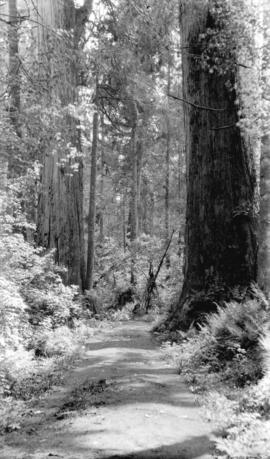
![[Trail through trees in Stanley Park]](/uploads/r/null/1/a/1a8c543b4e16881d56d13a628ae673cab947df813c029d96e2bc5112f2832c0f/1df4e373-ea98-47ba-9195-e207575f6d9c-A09668_142.jpg)
[Trail through trees in Stanley Park]
- AM54-S4-: St Pk N61.1
- Item
- 28 May 1919
Part of Major Matthews collection
49 results with digital objects Show results with digital objects
[Trail through trees in Stanley Park]
Part of Major Matthews collection
Part of Major Matthews collection

Part of Major Matthews collection

Part of Major Matthews collection
![[Trail through trees] in Stanley Park](/uploads/r/null/8/7/87832599c93587c19ddec4fe6b46467d9bb016854a09fd97efc5d1137239fc57/a10c7280-ad7f-4130-8b40-f193fbfda946-A09674_142.jpg)
[Trail through trees] in Stanley Park
Part of Major Matthews collection
![[Trail through the trees in Stanley Park]](/uploads/r/null/8/c/8c6d5bd6aa4748393f30121dfd4c1ad1cbb5e9a71d3ee88e53dc59fd129403ba/75775d07-2a2c-4ea2-9db2-eb6167059d53-A09687_142.jpg)
[Trail through the trees in Stanley Park]
Part of Major Matthews collection
![[Woman on path at entrance to Stanley Park]](/uploads/r/null/0/9/096250a50f9400c768a91da2b13a285033291a21f9933157296482b98291ffe9/dab8fa03-2bdc-44dc-969b-d6cc8a30771c-A09694_142.jpg)
[Woman on path at entrance to Stanley Park]
Part of Major Matthews collection

Part of Major Matthews collection
Photograph shows a trail through Stanley Park.

Part of Major Matthews collection
![On the foothills [at the upper end of Lonsdale Ave]](/uploads/r/null/7/7/7717bc70abb9bba6e0f034c7e96e90df6d75ccc0d8dcd565867921d43124ad1d/efd021b2-d150-43bc-b76b-d4d426f45a53-A19185_142.jpg)
On the foothills [at the upper end of Lonsdale Ave]
Part of Major Matthews collection
Photograph shows Arthur Tinniswood Dalton with a man, possibly his father, on a road colloqually called "Pig Alley" heading up Grouse Mountain.
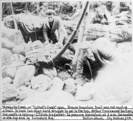
Part of Major Matthews collection
![[View of pack horses on trail to Mount Robson]](/uploads/r/null/4/4/44ea22d884ceb88a1652ac725fbea5dc9917a2f57dd1c2dabb04f601d2c9ac37/e59e9b28-f3dc-40c5-99e2-07eb2a42c6db-A32802_142.jpg)
[View of pack horses on trail to Mount Robson]
Part of Major Matthews collection
Photograph shows an avalanche area
![[The Crown Mountain trail]](/uploads/r/null/5/e/5eb4392944211be4ccad7499898563f1413d2239b190a50dcb0be777a0b1a6f3/99e723ec-0dda-456d-8e9b-c265ecb7a3b5-A32971_142.jpg)
Part of Major Matthews collection

Rustic bridge. Stanley Park, Vancouver, B.C.
Part of Major Matthews collection
![Winter Trail on Skaguay [Skagway] River](/uploads/r/null/6/7/674b4bdbec738165c57c0f2d54e15dbfbd1420b9bebe68e88fda401d840b5a64/0370f36b-9041-4f42-8b23-bef2cf53cf27-A37393_142.jpg)
Winter Trail on Skaguay [Skagway] River
Part of Major Matthews collection
Photograph shows W.H. Lang and party
![Skaguay [Skagway] Trail Alaska](/uploads/r/null/d/9/d9b982a440c6ef469ce847f748a73fd53af9e692f76d53eda0ed19410e2486d7/7f7e1f00-b536-4134-94c8-b9788ea30c08-A37394_142.jpg)
Skaguay [Skagway] Trail Alaska
Part of Major Matthews collection
Photograph shows two dead horses
![Winter Trail Through Box Canyon on Skaguay [Skagway] River](/uploads/r/null/0/7/0785fff790a14b7292efb2e43528871758ca896d378d36efa7593e2cec6e5dd7/67f52ed1-58bf-4a07-ba69-a2b9eefb6439-A37395_142.jpg)
Winter Trail Through Box Canyon on Skaguay [Skagway] River
Part of Major Matthews collection
Photograph shows W.H. Lang and party

The Bridge Across Porcupine Creek
Part of Major Matthews collection
Photograph shows W.H. Lang and party
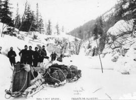
Near First Bridge En Route For Klondike
Part of Major Matthews collection
Photograph shows W.H. Lang and party
![At The Cutoff Skaguay [Skagway] Trail](/uploads/r/null/b/7/b799893aa32e56051e2204b1d1b090f413674f416b42ae10b65eefb72c815edc/c1c4b0bd-3c4f-494c-97c2-603b5b3b99d0-A37402_142.jpg)
At The Cutoff Skaguay [Skagway] Trail
Part of Major Matthews collection

Part of Major Matthews collection

Part of Major Matthews collection

Part of Major Matthews collection
![[View of the Lillooet-Burrard Inlet Trail south of Mount Garibaldi]](/uploads/r/null/a/5/a545ac048fb5d9fd84dfaff5b6f294cdcc3d0714ee8a8dca342c0cd66d3308a3/20b4e14c-6ced-4b05-b66c-1f38b485161e-A33439_142.jpg)
[View of the Lillooet-Burrard Inlet Trail south of Mount Garibaldi]
Part of Major Matthews collection
![[A part of the Lillooet-Burrard Inlet Trail south of Mount Garibaldi]](/uploads/r/null/2/7/276615923edd27e18a3a3581d7553c4fb0d1254339d7ffdc1a34ed405d57af5f/a1f98700-798a-47a7-85ff-8f592653097e-A33434_142.jpg)
[A part of the Lillooet-Burrard Inlet Trail south of Mount Garibaldi]
Part of Major Matthews collection

Autumn in Stanley Park, Vancouver, B.C.
Part of Major Matthews collection
Photograph shows three men in a carriage on a dirt road surrounded by trees and bush. J.S. Matthews' notes with print or negative in Archives.
![[Woman standing on path] Stanley Park, Vancouver, B.C.](/uploads/r/null/e/f/ef88f6091a23e7328c8e48a8b0ed56ac4353ec06cd2bc4b954102aa77926bc9d/459a380b-894a-4ca4-aa24-5cdb1ac6e740-A04015_142.jpg)
[Woman standing on path] Stanley Park, Vancouver, B.C.
Part of Major Matthews collection
Photograph shows a mounted photograph, surrounded by flowers.
![[Woman on path at Brockton Point] Stanley Park, Vancouver, B.C.](/uploads/r/null/5/0/502014bde480027c6c971f06a7ba5782198be8cd870d41d923f08d60cab6d080/fcec5119-a5d6-44fc-9eeb-7f5918a72a9b-A04012_142.jpg)
[Woman on path at Brockton Point] Stanley Park, Vancouver, B.C.
Part of Major Matthews collection
J.S. Matthews' notes with print or negative in Archives.

Part of Major Matthews collection
J.S. Matthews' notes with print or negative in Archives.
![[C.P.R. construction trail in mountains]](/uploads/r/null/2/8/287d2a5424b7acf5119010b9aa841746490e130012987c63dc667ea6e5bdbc8f/081070d9-5cc5-4b91-ae24-d57d57d07c4c-A04197_142.jpg)
[C.P.R. construction trail in mountains]
Part of Major Matthews collection
J.S. Matthews' notes with print or negative in Archives.

Rustic bridge. Stanley Park, Vancouver, B.C.
Part of Major Matthews collection

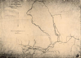
Sketch map of part of British Columbia showing trails and routes of communication
Part of Major Matthews collection
Item is a photostatic copy of a manuscript map showing trails and routes of communication in a portion of British Columbia from the Canada-U.S. border in the south to Seaton Lake in the north, and from the coast to Vermillion in the east. The section of coastline extends from Semiahmoo Bay in the south to Point Atkinson in the north. Map shows the location of mule trails and wagon roads, and includes a trail in progress from New Westminster to Burrard Inlet (North Road), trails from Whatcom to Hope and Semiahmoo to Derby, the Hudsons Bay Brigade Trail, Douglas Road, a trail proposed by Colonel Moody from New Westminster to Fort Hope, and the Dewdney Trail. Included with the map is a 1949 letter from Major Matthews, City Archivist, to J.M. Pearce in which Matthews describes the map, and a 1952 enquiry from L.B. [Housler] for a map showing the Dewdney Trail.
![[Benches along trail in Stanley Park]](/uploads/r/null/b/7/b70ae5952d325b9baa97932b8529f242a0c270b869a92d2a06faa0aec19c313b/ebb77758-01cf-47f4-8211-b426d692f9b9-A08069_142.jpg)
[Benches along trail in Stanley Park]
Part of Major Matthews collection
J.S. Matthews' notes with print or negative in Archives.
![[Man seated at edge of path leading to St. Alice Hotel, Harrison Hot Springs]](/uploads/r/null/2/e/2e934fe9d54768bb9d1e1a0a33a533bc0881d9fa4d70d14ba790e28c0bb9a5e1/51c9c96b-c0e2-411f-b0e5-c8c179f2176b-A04506_142.jpg)
[Man seated at edge of path leading to St. Alice Hotel, Harrison Hot Springs]
Part of Major Matthews collection
J.S. Matthews' notes with print or negative in Archives.
![China Bluff on way to Boston Bar - Frazer [Fraser] River](/uploads/r/null/7/b/7bd123659bbb4dc0aa3970fe573df39cbf2f6b12f7e5747300a89968847289cf/51f452e5-0b09-4380-a408-9ad604c969d5-A22917_142.jpg)
China Bluff on way to Boston Bar - Frazer [Fraser] River
Part of Major Matthews collection
Sketch map of part of British Columbia showing trails and routes of communication
Part of Major Matthews collection
Item is a photostatic copy of a manuscript map showing trails and routes of communication in a portion of British Columbia from the Canada-U.S. border in the south to Seaton Lake in the north, and from the coast to Vermillion in the east. The section of coastline extends from Semiahmoo Bay in the south to Point Atkinson in the north. Map shows the location of mule trails and wagon roads, and includes a trail in progress from New Westminster to Burrard Inlet (North Road), trails from Whatcom to Hope and Semiahmoo to Derby, the Hudsons Bay Brigade Trail, Douglas Road, a trail proposed by Colonel Moody from New Westminster to Fort Hope, and the Dewdney Trail. Included with the map is a 1949 letter from Major Matthews, City Archivist, to J.M. Pearce in which Matthews describes the map, and a 1952 enquiry from L.B. [Housler] for a map showing the Dewdney Trail.
![[Woman at wooden staircase near path, Stanley Park]](/uploads/r/null/4/5/457c89c6028bf23763596d6fdc697d21ae95ab0da8b9e499329612e0e3d1d93d/2e27cf54-52d9-4482-9bfd-70bb3ab160bb-A04017_142.jpg)
[Woman at wooden staircase near path, Stanley Park]
Part of Major Matthews collection
J.S. Matthews' notes with print or negative in Archives.
![[Men and women standing on trail at Stanley Park]](/uploads/r/null/f/a/fa6f5f79acc7cf977815f3356d745b18c689f6d293be9af218c2b3b39c02472b/4c70017d-7acc-47ee-863d-869539dd7633-A04021_142.jpg)
[Men and women standing on trail at Stanley Park]
Part of Major Matthews collection
J.S. Matthews' notes with print or negative in Archives.

Winter in the park, Vancouver, B.C.
Part of Major Matthews collection
Photograph shows a man walking down a snow covered trail.

Part of Major Matthews collection
Photograph is a copy of the two photographs of forest scenes in Stanley Park.

Part of Major Matthews collection
Photograph is a copy of two photographs of forest scenes in Stanley Park.
!["Morning, and a sheen of silvery mist". Stanley P[ar]k. Van., B.C. and "Quarrellin...](/uploads/r/null/b/b/bb31dc05c734b3129e139e5da0a4619420df00f5bb0ff194ef6ed6d4c54a157e/13b22f1c-0217-4b10-8e72-6b9c9a9b9952-A04477_142.jpg)
Part of Major Matthews collection
Photograph is a copy of two photographs showing forest scenes in Stanley Park.
!["Among friends". Stanley P[ar]k Vancouver, B.C. and North Vancouver and Brockton Point ...](/uploads/r/null/8/3/836b24f370020072f8b494b0b92a625c87eefc54eb082c7e139a76be86728cc4/09892412-8cf4-46fa-8c7e-5e160b0885db-A04478_142.jpg)
Part of Major Matthews collection
Photograph is a copy of two photographs showing scenes of Stanley Park.
![[Man standing next to large tree near trail]](/uploads/r/null/3/0/30e5e69b62e1658fb3b42dcd70ee275a60e46fd08f33479a7902c416647715ca/72d9174f-d969-4ce3-8d2d-a96fc4f21098-A04718_142.jpg)
[Man standing next to large tree near trail]
Part of Major Matthews collection
![[Split logs laid down to form a path through forest]](/uploads/r/null/a/9/a9421aac3e5fe668e75422b796bfd571005fc914c04f908733d10afbf3821dd5/92fa2da2-ac1a-4967-8e40-d41f78135dc0-A04795_142.jpg)
[Split logs laid down to form a path through forest]
Part of Major Matthews collection
![[Trees and section of seawall] Stanley Park](/uploads/r/null/e/f/efbae323723982ea66beb442ede1586efb8c0141876e371c048e7cba3286b3b6/ad79e5e6-7d83-4584-ad3d-fd2b9cb36654-A07695_142.jpg)
[Trees and section of seawall] Stanley Park
Part of Major Matthews collection
J.S. Matthews' notes with print or negative in Archives.
![[Two men standing on trail in clearing in front of log cabin]](/uploads/r/null/c/d/cd6b937dd6b1c45f652776e9b0f14dfaccc11ca7c1f943c5e5ee28dc8c139188/2a9870f3-47da-40d4-a1f8-efc853801979-A07797_142.jpg)
[Two men standing on trail in clearing in front of log cabin]
Part of Major Matthews collection
![In the forest [at Stanley Park showing an old logging road and skids]](/uploads/r/null/6/f/6f8d2299d299a608077d95982fb4f570321947c778ff7515fc115c588949c78c/48e6f436-6352-4ba5-a94a-2a097c4ec7a0-A21481_142.jpg)
In the forest [at Stanley Park showing an old logging road and skids]
Part of Major Matthews collection
![Which road? [Woman standing at a fork in the trail at Stanley Park]](/uploads/r/null/6/2/6250692a9c7c71b5412c44959ba1a4f11af91e579f1aed4fb0fcd696d3d3496f/e50948ec-0823-4745-954f-7530c6ecbbf4-A21491_142.jpg)
Which road? [Woman standing at a fork in the trail at Stanley Park]
Part of Major Matthews collection