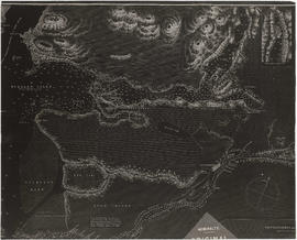
Map is a photostatic copy of a plan of lots offered for auction in Hastings on 10th July, 1869, indicating which lots were sold and which lots were reserved. Plan also shows the locations of government buildings, a church, a hospital, Oliver M. Hocking's house and stable, the road from New Westminster to Burrard Inlet, Mae N. (Broughton), and [bearing] to Moody's Mill. Includes a note by J.S. Matthews, 1933, titled "First Sale of Lots, 1869 (City of Vancouver), Hocking's." The map was certified by Robert Beaver, C.C.L&W, as a true copy from the map in the Lands and Works Office, 21st June 1873. Also included with the map are drafts of the text by Major Matthews.


![[William Davison]](/uploads/r/null/f/a/fa43167b643c37fe056bc133d76edb0ade70805ee2d3adfa4d3f9430fea010e1/05654017-0e9b-4e77-ae22-72c46e549db2-A34210_142.jpg)
![[Jerry Rogers]](/uploads/r/null/d/4/d4b8c9b4c348ffb0894f49e712d772efd517fe9e6e619621d7ed8c1c0897aa79/a4390193-65a5-46be-96c8-90578fec7cbc-A34598_142.jpg)
![[Edwin Woodward]](/uploads/r/null/2/1/2151fd00026a2820ff173170a7a198fc07914834a884eeb5f75a307b6fd9d2dc/15c0f3e6-5a67-4743-af92-cbd20dbe56d7-A34632_142.jpg)
![[Robert William Gordon]](/uploads/r/null/9/8/98758c7eaadef8d298784536c769c0fc806c34f294fb3f742cad975a5419835f/b3646f24-a2f1-48b7-beec-77d688d85b69-A34949_142.jpg)
![[Mrs. Robert William Gordon]](/uploads/r/null/8/8/88341241e752bede24390e63ba413dabf5959db0dfda33c860da79a5f81b9180/71393305-0075-4d76-b593-23c2c02daa9b-A34950_142.jpg)


![[Reverend Thomas Crosby]](/uploads/r/null/0/d/0da38a34ecdd1cf4990a7b444fe53f93f143995ef89d1e192891dd3eb57257fc/dedb946b-31a7-4e39-8b43-04493d16a4a5-A35219_142.jpg)
![[A group of men]](/uploads/r/null/4/8/48711fe7d602bfa18ed01075cb65a229aef71afa41d0f36ffc2f299ec7edb50f/0648e88f-5c73-410c-ac96-c82b0035e4be-A49505_142.jpg)
![[Angus Fraser's House - N.W. corner of Cordova and Carrall Streets]](/uploads/r/null/9/9/995ef7ae1fb66273a0b978f1c9e187669320344ed02a22fa1717afc6471cfa10/fa066864-aefb-4efe-b9cc-16d3c400289e-A24574_142.jpg)

![[Thomas Dunn and family]](/uploads/r/null/2/2/22bbd1f505d2d28cdbf7acb2f811dee70cb452f85c184223032499675f73e093/b2f454fd-3ef7-487e-9c34-5812ec8c7a67-A34372_142.jpg)

![[Walter Moberly]](/uploads/r/null/2/8/2880f69372cb5d8a300bc037ad0514c97301a126ea0d120808ea66f7b1d34e07/a7012f80-8657-492f-9bb4-9d944267b356-A34775_142.jpg)
![[Group portrait of W. Johnson (far left), H. Stephens, C. Stephens and J. Anderson]](/uploads/r/null/b/7/b71ea85767c523f0a22fa79812276bc711452e515b96e6e5a1118f05f4eb2a80/26ca1620-d106-4919-af29-d3eeb3090b68-A34385_142.jpg)
![[L.A. Hamilton]](/uploads/r/null/1/8/1800f20b7456d1da34fb1cea62341b799f418dae0fdd0ff8768713b8043da549/d075f430-b3fe-45d4-b58b-26c1aed96267-A34343_142.jpg)
![[John McDougall]](/uploads/r/null/8/f/8fd5de7de7ca143ecebd924843f763e29d189dc76859a981462f64161a8d2bd4/8a884f98-f75e-48fc-954c-46af98672ca7-A34993_142.jpg)
![[Head and shoulder portrait of Joseph Silvey, also known as " Portuguese Joe"]](/uploads/r/null/2/6/e/26ee06e897828579a880c6f780cdb63ff6375d55077001733e19a7a7febc2b4b/3f321a29-6eaf-4931-8145-5cf6e3ebcf4c-PortP656_142.jpg)
![[Mr. and Mrs. Mizony]](/uploads/r/null/1/9/192470c3720ad88d4b993f5b2031c7ca1fcd2b52e1eb50d6c9a709196bc58de2/bc6905ca-a47f-447c-a287-3b9928fc9251-A34230_142.jpg)
![[Mrs. Alfred Wallace (nee Eliza E. Underhill)]](/uploads/r/null/0/6/06e15fe58b2f3468c8bd673e5fe67f361139a22c218070824c772b972f5e7afb/78c7d557-9e18-4b06-8714-1bcfb1bfc95f-A35526_142.jpg)
![[Unidentified group of tennis players]](/uploads/r/null/9/6/961636a9c6470eaf49a74e1027e61bfddb0eb69b6ee3ad759cc619d8d9c2f514/e4b6e01a-2ca2-47bc-becf-c7e1890c6e19-A63054_142.jpg)
![[Alfred Wallace]](/uploads/r/null/0/3/03a8f6950374b3c6b18d6fdafb8b86ba0ce0364b8a31144a8d5072bd491e1b75/bba982b0-9d11-439e-8637-e9ce52cf4ae0-A35527_142.jpg)
![[Mrs. Saville (nee Sentell)]](/uploads/r/null/1/a/1aa4a3080e2f68ac7200ae46fb8f88b1d67602383db1016982b293686682e605/5d567f38-a27a-4679-88dc-64cd29a160db-A62068_142.jpg)
![[Mrs. John P. Patterson (nee Emily Susan Branscombe)]](/uploads/r/null/b/9/b9293aacc440a7efd772fe184d3365143fac02af63453e29ec30941d80757e6e/ec576f86-77dd-4ff4-8be2-167bdf50a659-A34326_142.jpg)
![[Miss Elizabeth Lucy Crickmay (Mrs. A.R. Sherwood)]](/uploads/r/null/0/0/008adfcd91a017a5a5974086a0cb4898820f370e17a6748c1cdec62ac86913d9/d869df10-09a6-49ff-bd2c-6bb9a2e8a28b-A34352_142.jpg)
![[John E. Insley]](/uploads/r/null/8/a/8a067a10e275888143851fee309ad41ccaf4b6c5d828a2dfaefc770387985469/670cdfad-f5bc-40ef-9de3-82807bce2c88-A34257_142.jpg)
![[Mr. and Mrs. John Cronk Vermilyea and their children]](/uploads/r/null/6/9/69b430cfb483a8bcd46670b11dbd26d076445a3238551cf03ccb5b1a7fd46a6d/d4bc191b-6ab2-4e71-afc3-b894b1e4b93b-A36036_142.jpg)
![[View of Spratt's Oilery]](/uploads/r/null/3/1/317c76a2e0072e40347023a1723d05688215452eec607e96e71c43c077ff9e63/7150ded4-cdbe-4238-9398-066acbca1cb8-A24570_142.jpg)
![[Otway John James Wilkie]](/uploads/r/null/a/7/a71259ade4054da705749a7d3bcc833c2538cc909d7a49e6d7dd3c4c5b44604b/fffe999f-f6fc-4d74-aa8d-abedc60e1da9-A34436_142.jpg)
![Sprat[t]'s Fishery Coal Harbour](/uploads/r/null/9/a/9af227133eaa610fab2308e146d52d8883d36e591b0356a100679bbd8c8f09d7/74445e85-b89f-47d1-803d-12160f1e3b26-A24577_142.jpg)
![[Exterior of the first St. James Church near the foot of Main Street]](/uploads/r/null/a/9/a9437150ad25629494129704a83c44923ba953412726e9fecca35699a0e74730/90edf856-765a-4c0b-b61d-8aa204a331f0-A25556_142.jpg)

![[Russell A. Leonard (without hat) and an unidentified man]](/uploads/r/null/a/4/a45b3ba5df92a2521b16f113ec6f10a0291e49c1883cf35ecd2e3bf201a0c37f/4f5f9a9c-41d0-4364-b84c-382a3f0b08fb-A35818_142.jpg)
![[The Nye family]](/uploads/r/null/8/9/89094104aa5dc4f9bf323fca9edcb21d53c4981d029c62915e9fb841a4b7cba3/fdb6fd29-3024-46b9-84e1-663e17dc590c-A60961_142.jpg)
![[Exterior of the Sunny Side Hotel - 1 Water Street]](/uploads/r/null/8/9/897f68bf029ca5e8cb6e8fe72b04a693805b6e834ffbe6b20fbbb00bd51b1e2f/20f99902-0bd1-40cf-999e-e84ca003c5c7-A24829_142.jpg)
![[Exterior of Smith and Freeland Hardware and General Grocery Store]](/uploads/r/null/6/8/684ea7b5695d7113e814a2e431450201c8b27c17f17eba92daca371ba5a09703/85892aa9-73f6-46b5-a1a7-762bc69c8438-A61133_142.jpg)
![[Corporal J.Z. Hall, B.C.B.G.A.]](/uploads/r/null/9/3/93d0d01334b02df00007f3aea5208a5c69bf50bc34754de33b2d6e90377e3e1e/2c9361c9-e6ee-47af-bf69-b076f81fc0a7-A34197_142.jpg)
![[Interior of the Chapel of St. James' Church at Oppenheimer Street and Gore Avenue]](/uploads/r/null/4/4/4445bb45ff1d2b939cefa69a4aaae39312efac53e0ac7baec3a9d404e7fa6e1a/8d48c1f6-5773-4d72-8a84-2f8e934372b9-A25662_142.jpg)
![[View of Brockton Point from the foot of Thurlow Street]](/uploads/r/null/c/d/cd46135558eac25edd34ff48e7dadc132d4b7624fc34c66bc82ef39569206bcb/867e71c0-5a12-4356-933c-b9e19cd34e15-A43319_142.jpg)