[Looking east from the Stanley Park bridge to Coal Harbour]
R.M.S. "Empress of Asia" leaving harbor. Vancouver, Canada.
The Harbor, Comox, B.C.
Brockton Point looking east
City from Stanley Park, and first gasoline service station. Imperial Oil Limited.
Coal Harbour [showing] Deadman's Island and Stanley Park
[View of the harbour, C.P.R. Pier 'D' and railroad yard from the roof of the Post Office]
[View of Victoria, B.C., from the Parliament Buildings]
[View of West End buildings, Coal Harbour, Stanley Park and North Shore mountains, looking northwest from Hotel Vancouver]
[Vancouver Rowing Club clubhouse and dock in Coal Harbour at the foot of Bute Street]
[Vancouver Rowing Club clubhouse and dock, in Coal Harbour at the foot of Bute Street]
Looking over Brockton Point, Stanley Park
Port Arthur, Ont., from harbor
[View of Pender Street between Burrard and Thurlow Streets, showing houses and ships in harbour]
[North to north east view of downtown from the Birks Building showing Burrard Inlet and the North shore in the background]
[Northern view of downtown Vancouver from the World Building at 500 Beatty Street]
[Native Indian canoe races in Inner Harbour, Victoria]
[Northwest view of Vancouver from Dunsmuir and Hornby Streets]
[H.M.S. "Rainbow" in Vancouver harbour to watch over the "Komagata Maru"]
[Rowboats in harbour for regatta]
[East half Granville Island before filling]
East half Granville Island before filling
East half Granville Island before filling
Filling of government dock at Victoria, B.C. [Victoria outer dock]
Ocean Falls [harbour dredging]
"Empress of Asia" at C.P.R. Pier B-C [with "Melanope" alongside]
[Aerial view looking east over Stanley Park, Coal Harbour and Burrard Inlet]
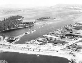
[Aerial view of North Vancouver, First Narrows, Stanley Park, West End, Coal Harbour, Burrard Inlet, Vancouver Waterfront and Downtown]
Section of False Creek
West half Granville Island before filling
[Aerial view of Vancouver Harbour looking east from Lost Lagoon]
[Sailors rowing to shore from the H.M.S. "Amphion" in Vancouver harbour]
[Two boys watching boat enter Bull Harbour]
[Ships in Vancouver Harbour]
Esquimalt Harbour
[View of Coal Harbour looking west from the foot of Broughton Street]
[View of Coal Harbour, Deadman's Island, part of Stanley Park, and the North Shore mountains, from John Morton's clearing at the foot of Thurlow Street]
Coal Harbour Vancouver, B.C.
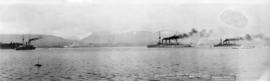
Japanese Warships on visit to Vancouver B.C. Feb. 6-12/1925
[View of the harbour, C.P.R. Pier 'D' and railroad yard from the roof of the Post Office]
[View of] Coal Harbour and Stanley Park from Georgia [Street]
[Grain ships in Vancouver Harbour waiting to load grain]
[H.M.S. "Rainbow" in Vancouver harbour to watch over the "Komagata Maru"]
Vancouver Harbor
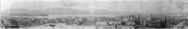
[360 degree view of Vancouver from the roof of the second Hotel Vancouver]
[North to north east view of downtown from the Birks Building showing Burrard Inlet and the North shore in the background]
[Northern view of downtown Vancouver from the World Building at 500 Beatty Street]
[Northern view of downtown Vancouver from World Building, 500 Beatty Street]
![[Dock and boats in Esquimalt harbour]](/uploads/r/null/0/e/0e25442aad79db6eaeeaaa96cb15d95efbbfa07cfa78b61916338d055010bac7/4cdf1f29-4665-4203-b3ee-0bc8988719f3-A07650_142.jpg)

![[Looking east from the Stanley Park bridge to Coal Harbour]](/uploads/r/null/c/5/c5d5a12a1c9782ab5a8523900877fe279312841636d16b6c49d45f78c661b618/886c6082-bc19-41a2-a743-6880e2727074-A43209_142.jpg)


![Coal Harbour [showing] Deadman's Island and Stanley Park](/uploads/r/null/d/6/d6ce3aeb165a91b522ef077ca8156f7e3a8ab8b628022e341045a857c0742bbc/b376f1e6-bd3a-4ad5-92c6-958dc0d2db65-A09656_142.jpg)
![[View of the harbour, C.P.R. Pier 'D' and railroad yard from the roof of the Post Office]](/uploads/r/null/e/4/e403caef05acedfc9e78203f7cac185e22853ec36a357deb2f1e3cbb517c0f44/0ce56549-03f9-4349-9a5e-267ba26928df-A09879_142.jpg)
![[View of Victoria, B.C., from the Parliament Buildings]](/uploads/r/null/2/5/25b93cd5368b86d92ffa8dea30a9aae210661abc2c05e903a2c0d24dd47158b2/a4f5e146-cd11-44c9-af08-dffe28bbc8dc-A07653_142.jpg)

![[Vancouver Rowing Club clubhouse and dock in Coal Harbour at the foot of Bute Street]](/uploads/r/null/8/7/8718dcec36599374e6ce423106f3bb1e50b1b752d8db507d8b08007effe02300/1f6af934-f999-44dd-9061-62c3594bc3e6-A08053_142.jpg)
![[Vancouver Rowing Club clubhouse and dock, in Coal Harbour at the foot of Bute Street]](/uploads/r/null/d/2/d2f7d67e632b7c2d17d9142941c783d2817e1558aba2c484ce203583c6a8b56a/2fcab23e-13cb-44cf-890c-3ddcdfa34b69-A08054_142.jpg)


![[View of Pender Street between Burrard and Thurlow Streets, showing houses and ships in harbour]](/uploads/r/null/f/0/f00ac5f1f323bcee985db1f23354ad1a01e377075c05ff005e8291cfa6ea59bb/257c6f06-9e48-4b7a-8964-00daf6a2493f-A07603_142.jpg)
![[Northern view of downtown Vancouver from the World Building at 500 Beatty Street]](/uploads/r/null/c/5/c5a97982fe48806e527a2356c3596800ee386904520184558d1eb65128635907/f3ea7ce2-2a4c-40da-a5a9-2ccfa6c170b1-A63886_142.jpg)
![[Native Indian canoe races in Inner Harbour, Victoria]](/uploads/r/null/0/b/0bda6af6044a499cb77794faa4697c0d3b543bfdb67d3fcfbefc6fb24c0058d4/e732393e-bed4-45e2-955a-ad84e9fa5cd0-A04498_142.jpg)
![[Northwest view of Vancouver from Dunsmuir and Hornby Streets]](/uploads/r/null/8/8/88e94ad7604ed40fb7780d502fd141151ebddd9bddf50fa36b4b55a7abda9b58/e8c12a8c-3224-4083-b222-e4b83a4a6952-A65789_142.jpg)
![[H.M.S. "Rainbow" in Vancouver harbour to watch over the "Komagata Maru"]](/uploads/r/null/3/d/3d250a742a32a83e66644682e0c1d97d676269b1e4869498d58ed91b488466b7/7f6e9512-4848-4216-b137-cc33138cab01-A08341_142.jpg)
![[Rowboats in harbour for regatta]](/uploads/r/null/9/d/9d458757030e0adf87d4850d9f3f4fc08b05bd5f17091a77b867ead298e8110e/dc3b04e5-0d4d-4ef6-b733-b8b52c8fcbef-A07610_142.jpg)
![[East half Granville Island before filling]](/uploads/r/null/7/7/779c84832492846bbaaf82b09675d06ff7c3ab6303167b3827dc162b403089ef/daa3991d-6801-47d2-a003-486fb768fb00-A31771_142.jpg)


![Filling of government dock at Victoria, B.C. [Victoria outer dock]](/uploads/r/null/a/c/ac3dfcbfd7931077bc2fd044d9ac56f115bc15a0a358e22caf0d0dd50edde8b7/dcf75c65-ad8b-4b52-b57c-bf2b8a6aefd3-A31777_142.jpg)
![Ocean Falls [harbour dredging]](/uploads/r/null/1/e/1e7e09e17dcb3d0b28a30119bceaa2f16244f3ff09e4db0d582bf8f4d720d60c/64cfdccc-461e-4627-b615-908f9ba91921-A31758_142.jpg)
!["Empress of Asia" at C.P.R. Pier B-C [with "Melanope" alongside]](/uploads/r/null/0/f/0fb16442c7c62c275d85acaa7682f0d3fa8286edc35254c9405675c22e5550ad/b0542e8a-245e-4cf5-a9ab-330cf0dd2d68-A08348_142.jpg)
![[Aerial view looking east over Stanley Park, Coal Harbour and Burrard Inlet]](/uploads/r/null/d/0/d02fee694c486ac2accdeefb505d0dae5fcb42789ef16de49322d845e3c04b44/be8c34ce-7c09-4c0e-a395-f083c9134080-A43248_142.jpg)


![[Aerial view of Vancouver Harbour looking east from Lost Lagoon]](/uploads/r/null/a/7/a7c598133f7f2c78a6bb65602262bc193ceb787389db5cd31ded3868025265ca/72eb674f-7c20-4ecc-a618-3a1e88e660c8-A62798_142.jpg)
![[Sailors rowing to shore from the H.M.S. "Amphion" in Vancouver harbour]](/uploads/r/null/9/b/9bfc3c89bfb227c2ed0b8630533f99722a1277d24cb1e70d34c7740bb5438220/9d00534a-5cfe-42bf-819c-c9fceb9dbf60-A07602_142.jpg)
![[Two boys watching boat enter Bull Harbour]](/uploads/r/null/e/f/ef96d3d9dfb3dcfe7f79214898e35aa876eda5260f5360b9b123ca3620bf651f/62f4ecf2-2cd4-4176-9222-7d45f15e67b5-A09300_142.jpg)
![[Ships in Vancouver Harbour]](/uploads/r/null/d/6/d629566f7cb9f7a78af71c85ba3ea4a2cf7167728b91400cee1d65fd777443b3/fbfab785-d4fa-4637-8632-cf9d4b4bddca-A08055_142.jpg)

![[View of Coal Harbour looking west from the foot of Broughton Street]](/uploads/r/null/9/3/938ee0983c20bbbe94d9286541d172633e29b57b47a906f60e6e43fc2d15dda0/0fd8b222-d407-4f8f-a363-f7b88343cbe3-A08809_142.jpg)

![[View of the harbour, C.P.R. Pier 'D' and railroad yard from the roof of the Post Office]](/uploads/r/null/0/0/0017cc41004f72fbc45775cf71b997df93d9562b9877c14a78d5a30c67506a85/99ef2020-d62e-4cd3-b0b2-d2a012ec9e1f-A09878_142.jpg)
![[View of] Coal Harbour and Stanley Park from Georgia [Street]](/uploads/r/null/8/c/8c0a3b0f859c1a378c1463bc15fea75d46976a8289b6c84fcabef3840f06a3b3/490e919d-235c-4eb3-8693-3641e4b6285c-A09696_142.jpg)
![[Grain ships in Vancouver Harbour waiting to load grain]](/uploads/r/null/9/f/9f2d3f3a11fa665d2b9686746811b28a10898db2c7b0a189df714e3350a4e788/740c3740-7ce9-4588-aaef-b05f1037283a-A08765_142.jpg)
![[H.M.S. "Rainbow" in Vancouver harbour to watch over the "Komagata Maru"]](/uploads/r/null/6/1/61b73217fb5a51d95e7ef4f0e647b5c3d3b4980c689fc1853d7d896f87fdbf6c/c2b52350-ce4d-4193-bdde-523ef20b3c6e-A08340_142.jpg)

![[360 degree view of Vancouver from the roof of the second Hotel Vancouver]](/uploads/r/null/7/2/72f205b48502a927912ec46b74aa571f102f387013c2d6bce557a2420fd72aa7/269934f7-d517-4c58-b633-4167772f935b-A63168_142.jpg)

![[Northern view of downtown Vancouver from the World Building at 500 Beatty Street]](/uploads/r/null/9/5/95cc16c6b26e463eb28bc5ac8abec9ec6723150a2aefbca7850f264a2adff766/e88985ba-abeb-4d06-8eea-2bf10a834381-A63885_142.jpg)
![[Northern view of downtown Vancouver from World Building, 500 Beatty Street]](/uploads/r/null/9/9/997cc0ffa3d5b19d17a58c9f16a1c6f9855c9019e5f3249c78d456803ea58779/b52f219d-f015-40b1-96a6-c089ab3c8d70-A63175_142.jpg)