- AM54-S4-: Fl P5.6
- Item
- June 12, 1914
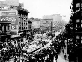
Part of Major Matthews collection
Photograph shows a parade on Hastings Street from Carrall Street
531 results with digital objects Show results with digital objects
Part of Major Matthews collection
Photograph shows a parade on Hastings Street from Carrall Street
![[Apartment buildings on Granville Street and 16th Avenue]](/uploads/r/null/f/a/fa784ffaa10d1453214e5173ea06e22c00f7a6530a93138d7a34e442453bd490/c98ab7d0-2707-401e-b79e-7ccb519e48d9-A09703_142.jpg)
[Apartment buildings on Granville Street and 16th Avenue]
Part of Major Matthews collection
![[Aerial view of Mount Pleasant, South Strathcona and Kensington-Cedar Cottage]](/uploads/r/null/7/5/75ea991fe8319eaffda79b314cbf20e281e35eb2cd8a89eaa898b492242d6282/05f856f3-0a45-41eb-94dc-46cb9d2f7ecf-A63348_142.jpg)
[Aerial view of Mount Pleasant, South Strathcona and Kensington-Cedar Cottage]
Part of Major Matthews collection
Photograph shows aerial view of the east end of False Creek, Thornton Park, Great Northern Railway and Canadian National Railway yards, Mount Pleasant, Strathcona, Grandview-Woodland, Trout Lake, Kingsway, Vancouver Technical School grounds, Renfrew playing fields, John Hendry Park, British Columbia Electric Railway Right of Way, Clark Park, Grandview Highway South, Great Northern Railway.
Part of Hastings Street, Vancouver
Part of Major Matthews collection
Photograph shows Hastings Street looking east from Granville Street and the Alfred Bunker and Customs House building (formerly L.A. Hamilton's house)
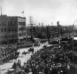
![[Inspection of 6th Regiment D.C.O.R. on Cambie Street grounds]](/uploads/r/null/2/e/2ef9009e1370d881168d5b9564a0b91823a5cd05e51b96a18f4d25d756105e43/8584938e-bbc7-4c8e-a54e-d62d04d8f8bc-A26733_142.jpg)
[Inspection of 6th Regiment D.C.O.R. on Cambie Street grounds]
Part of Major Matthews collection
Photograph shows the houses in the 600 block on the west side of Cambie Street and the spires of the St. Andrews Presbyterian Church and Holy Rosary Cathedral
Procession July 1st, 1890 Cordova Street
Part of Major Matthews collection
Photograph shows a view looking west from Carrall Street of street decoratations for Dominion Day and the Dunn-Miller Block
![[C.P.R. right of way between Cordova and Carrall Streets]](/uploads/r/null/c/0/c0eddc6c76c3133f7aa1feaa564938fbeae4de6371f4369968d4436a3da40345/40b2d0ae-d4eb-4b89-835a-a5d5332ce91f-A09979_142.jpg)
[C.P.R. right of way between Cordova and Carrall Streets]
Part of Major Matthews collection
Photograph shows man sitting on tree stump across from the Oyster Bay Cafe, which was the site of City Hall after the fire in 1886. J.S. Matthews' notes with print or negative in Archives.
![[View of] Hastings St. looking east from Hornby](/uploads/r/null/0/4/0470bb9219d126f8bcb407384a6c7238af2d2ff2ec3164ebef90189a224d525d/5d8e50db-7c1a-48a8-9ddf-e12cb8356c36-A09734_142.jpg)
[View of] Hastings St. looking east from Hornby
Part of Major Matthews collection
Photograph shows the Winch building, the stone wall around the home of C.T. Dunbar, a horse and cart in the street and wooden sidewalks.
![[View of Granville Street and 37th from the 5200 block, Shaughnessy]](/uploads/r/null/4/7/474b6dcf8ef35087ef9b76000cfbe43c23bd03fbd291f22d3ab8f42be1c46994/34a9c2f5-a821-4376-85e7-c727125ccbbb-A63184_142.jpg)
[View of Granville Street and 37th from the 5200 block, Shaughnessy]
Part of Major Matthews collection
Photograph also shows the Shaughnessy Golf Club and Course far right.
![[Cordova Street looking west from Carrall Street]](/uploads/r/null/2/a/3/2a3d21e3af3e2e85d0cf2207073f1924b9cb97f602b6dd55da2a4faee2693230/9b8051d7-2e39-42ec-b77b-929e8483001a-CVA371-1216_142.jpg)
[Cordova Street looking west from Carrall Street]
Part of Major Matthews collection
Photograph shows the Dunn-Miller Block
Part of Major Matthews collection
J.S. Matthews' notes with print or negative in Archives.
![[View of Cedar Street (Burrard Street), looking south from 1st Avenue]](/uploads/r/null/5/4/6/546bde6574cf2d5e2d523addd9591e1710627187bd04c3d93cb181a8630c2230/a0010462-bb2d-4682-af2b-e493c71a1bdd-CVA371-817_142.jpg)
[View of Cedar Street (Burrard Street), looking south from 1st Avenue]
Part of Major Matthews collection
J.S. Matthews' notes with print or negative in Archives.
![[View of Cedar Street (Burrard Street), looking north from 1st Avenue]](/uploads/r/null/9/5/1/951361df52bc39caa119f27dbb826caa9f8321d69bffb9d534bf12ba32aa9705/36b8f243-7cb9-4ced-b859-5c83a7f4b85b-CVA371-816_142.jpg)
[View of Cedar Street (Burrard Street), looking north from 1st Avenue]
Part of Major Matthews collection
J.S. Matthews' notes with print or negative in Archives.
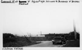
![[View of Cornwall and Cypress Streets near entrance to Burrard Street Bridge]](/uploads/r/null/8/6/d/86dac76ad8cb724cd7224e11a833da97224b6b85e5d0a9820f2a72347779b95d/28b56d29-93a3-4728-8ca0-db35bb4c412d-CVA371-815_142.jpg)
[View of Cornwall and Cypress Streets near entrance to Burrard Street Bridge]
Part of Major Matthews collection
J.S. Matthews' notes with print or negative in Archives.
![[View of Kingsway looking east from Slocan Street]](/uploads/r/null/5/3/8/538bef10d8f9525379c886d8f11cbe174269af436656e5528912805ae68083a6/a48926da-86d5-47c9-b715-e358d64c89db-CVA371-813_142.jpg)
[View of Kingsway looking east from Slocan Street]
Part of Major Matthews collection

Cordova Street, Vancouver, B.C.
Part of Major Matthews collection
Photograph shows a view looking west from Carrall Street showing the Dunn-Miller Block
![[Panoramic view looking north from the Hotel Vancouver]](/uploads/r/null/d/0/3/d032ae1a08ec1b68763941336f6a07708bf678235ae8cdf506cbbdc3fb10451d/98ea51ff-abce-48a9-9401-16834b8ba6a4-VanScP143_142.jpg)
[Panoramic view looking north from the Hotel Vancouver]
Part of Major Matthews collection
Photographs show the west side of the 600 Block of Howe Street, Manor House, Deadman's Island, the 600 Block of Granville Street, the Van Horne Block, the Hudson Bay Company store, the Homer Street Methodist Church, the tower of Holy Rosary Cathedral and other buildings and houses
![[Canadian Pacific Railway Pier 'D' fire]](/uploads/r/null/c/f/cf438fa385ddd1f4fef863a0a40f12979362af88e06b942c6a4b9d7457762ea4/56e93e6a-0ceb-4772-b267-0e46f31d9d21-A09130_142.jpg)
[Canadian Pacific Railway Pier 'D' fire]
Part of Major Matthews collection
Photograph shows crowds gathered at foot of Granville Street watching the burning of CPR pier.
Part of Major Matthews collection
Photograph shows the Flack Block and Northwest Mounted Police
![[Granville Street looking north from about Dunsmuir Street]](/uploads/r/null/9/7/97ead2853467a47e096b6533ca8b64418e751d5859d0c9f0c0e4cf01aac168ca/13f76c26-8671-4abe-a36c-5d7a92e7feb4-A37343_142.jpg)
[Granville Street looking north from about Dunsmuir Street]
Part of Major Matthews collection
Photograph shows a woman riding a bicycle
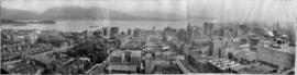
![[Panoramic view of Vancouver looking east, south and west from the Post Office tower]](/uploads/r/null/3/4/3440da1e98108d2cb1b9e915b9d5784f1ce26f037ac1f6597fb6f283670ef6fa/d87fd6ce-c19b-43e2-af52-69db5b1e0d1e-A63166_142.jpg)
[Panoramic view of Vancouver looking east, south and west from the Post Office tower]
Part of Major Matthews collection
J.S. Matthews identification notes on print.
![[Panoramic view of downtown, Vancouver from Granville and Hastings Streets]](/uploads/r/null/2/1/6/216cf899114250d1b31f38600b649f3b49bbd0c5882c6b5a6a9519d124d69cd5/addbb40b-0fc9-430e-8ebb-76d531606378-PANP92_142.jpg)
[Panoramic view of downtown, Vancouver from Granville and Hastings Streets]
Part of Major Matthews collection
Photograph is almost a 360 degree view. Buildings and some landmarks are identified in ink on print. This is a cropped version of PAN P92.1.
Written on the back of the print in what appears to be Major J.S. Matthews writing:
"Building permits issued.
Court House, superstructure, 7 Dec 1907 (addition, 30/3/1912)
excavation, 8 Mar 1907
Dominion Trust 21 Apr 1908
Carter-Cotton Bldg (Province Bldg) 5 Oct 1908 (addition Pender St 14/11/10)
Street cars and vehicles:- left hand rule of the road until 1921.
Have not investigated but this looks July or August 1908 or perhaps July-Aug 1909"
![[Panoramic view of downtown, Vancouver from Granville and Hastings Streets]](/uploads/r/null/b/6/b/b6b44d6ac0fb2fd61907ae9bad2a5792f8dce904b90fa1406d9c99ea2d36ee94/a76ddde8-2b68-4786-82cb-14470e682cd1-PANP92_142.jpg)
[Panoramic view of downtown, Vancouver from Granville and Hastings Streets]
Part of Major Matthews collection
Item is a photograph of downtown Vancouver. This is a cropped version of PAN P92.1.

Vancouver, B.C. "The livest and most beautifully located city in Canada"
Part of Major Matthews collection
Panoramic view (280 degrees) taken from the dome of the World Building showing the Beatty Street Armouries, the Cambie Street Grounds, Central High School, Vancouver High School, the Dominion Building, the railway yards and the eastern industrial areas
![[Northern and eastern view of] Vancouver, B.C. [showing Burrard Inlet, Downtown, False Creek and ...](/uploads/r/null/a/d/ad499a709643b866df0dd06ee0db3a33d39d0fae463dc917d66f4f31c3dac3ad/05fca819-4e81-4708-982c-e3af142f77cb-A63163_142.jpg)
Part of Major Matthews collection
Panoramic view showing Coal Harbour, Deadman's Island, the Westminster Avenue Trestle and Cambie Street Bridges, St. Andrew's Church, the Beatty Street Drill Hall and the Sun Tower
![[View of the 1900 Block and 2000 Block of Nelson Street]](/uploads/r/null/d/5/d58b220b2f356143bdd1652a781ab12a6ce66d5858da8ca763e64de2e942d685/71b1f0ef-346b-41e5-bfc5-1f4811088cec-A63162_142.jpg)
[View of the 1900 Block and 2000 Block of Nelson Street]
Part of Major Matthews collection
Panoramic view showing 2075 Nelson Street, 2045 Nelson Street, 2001 Nelson Street, 2040 Nelson Street, 2000 Nelson Street, 1966 Nelson Street and 901 Chilco Street, 2010 Barclay Street and 2005 Comox Street in the background

Part of Major Matthews collection
Panoramic view from Pender Street showing the C.P.R. car barge dock, the Immigration Building and Pier A and the squatter's shacks on Deadman's Island
![[Panoramic view of the West End from the Royal Alexandra Apartments at Bute and Comox]](/uploads/r/null/9/8/985335a21dea98e63e4ae59b265cd5facd76b274c32c24c513f0b0599777699c/93f413d8-dc73-483c-a3b8-fec37b879343-A63165_142.jpg)
[Panoramic view of the West End from the Royal Alexandra Apartments at Bute and Comox]
Part of Major Matthews collection
Sectional panoramic view showing houses and buildings in the 1200, 1300 and 1400 blocks of Comox Street, the Broughton Apartments, St. John's Presbyterian Church, Nelson Street, the Horse Show building, the Denman Arena under construction and the Mayfair, Beacionsfield and Nelson Court Apartments.

Part of Major Matthews collection
Panoramic view
Part of Major Matthews collection
Panoramic view
![[View of Hastings Street and C.P.R. pier D, looking north from Granville Street]](/uploads/r/null/c/d/cd716e572751f524920e0c020166f8c96bfa60f7da601f8032cd9b3d578a2dd4/2863a771-1db4-4f97-931f-7f471ab4eafc-A07845_142.jpg)
[View of Hastings Street and C.P.R. pier D, looking north from Granville Street]
Part of Major Matthews collection
J.S. Matthews' notes with print or negative in Archives.
![[View of Granville Street, looking north from Smithe Street]](/uploads/r/null/3/9/39a901e95da833c852652aabd7c0966acfe4a1d627b4178682e095e76b44dd01/b388b386-5580-414d-ad02-3bf2031ca1b7-A07841_142.jpg)
[View of Granville Street, looking north from Smithe Street]
Part of Major Matthews collection
J.S. Matthews' notes with print or negative in Archives.
![[View of Granville Street, looking north from Smithe Street]](/uploads/r/null/9/6/9667d6e640e7339c5d0943472450cc60e598aaf4eb457514914d2f4f80311eb6/c5152985-4031-427d-855c-7f8529c807e0-A07840_142.jpg)
[View of Granville Street, looking north from Smithe Street]
Part of Major Matthews collection
J.S. Matthews' notes with print or negative in Archives.
![[View of Granville Street, looking north from Smithe Street]](/uploads/r/null/0/b/0b5c32076a69f297084287f7b174db121542d7f90360c09d614f50f7640012c2/f08cb500-9570-4331-a87c-60d4813a9dd1-A07839_142.jpg)
[View of Granville Street, looking north from Smithe Street]
Part of Major Matthews collection
J.S. Matthews' notes with print or negative in Archives.
![[View of Granville Street, looking north from Nelson Street]](/uploads/r/null/3/a/3aa527f17ce611695d8b41f6f4c6ee411f43e56879dc47f41ef0f70b436539c8/38075fa5-5386-4913-a95b-89b9e476b270-A07844_142.jpg)
[View of Granville Street, looking north from Nelson Street]
Part of Major Matthews collection
J.S. Matthews' notes with print or negative in Archives.
![[View of Granville Street, looking north from Nelson Street]](/uploads/r/null/4/9/49194a4454f5e9291aebd8582c8e3ac650b75d485bc497fb7fe91ba906b159a8/13eefc22-cd84-4f6d-9a32-57b0e5f4b694-A07843_142.jpg)
[View of Granville Street, looking north from Nelson Street]
Part of Major Matthews collection
J.S. Matthews' notes with print or negative in Archives.
![[View of Granville Street, looking north from Nelson Street]](/uploads/r/null/f/4/f4f1430a342018d13f7fa787d1da979124f174672c7bd7e32385b130b978e1bf/94b4a911-126f-4280-aff2-52c4e88959a0-A07842_142.jpg)
[View of Granville Street, looking north from Nelson Street]
Part of Major Matthews collection
J.S. Matthews' notes with print or negative in Archives.
![[View of Cornwall Street, looking west from Chestnut Street]](/uploads/r/null/1/a/1af56c7e5aaf1d339a120a19d5bedb35bcd2ec42e7137dc543723f33303a6f41/14dee453-d001-4dac-94d1-5fba27f8553c-A07558_142.jpg)
[View of Cornwall Street, looking west from Chestnut Street]
Part of Major Matthews collection
J.S. Matthews' notes with print or negative in Archives.
![[J.S. Matthews standing on Cedar Street (Burrard Street) at 1st Avenue, looking south]](/uploads/r/null/4/c/4c62208479116462d798b0bc7aa3e2c0189c5f811d596a08d93dc4222663438c/c30120fe-1ae8-47f2-940c-9d551e70ef9b-A07557_142.jpg)
[J.S. Matthews standing on Cedar Street (Burrard Street) at 1st Avenue, looking south]
Part of Major Matthews collection
J.S. Matthews' notes with print or negative in Archives.
![[Empty lot at Robson and Howe Streets, surrounded by residences]](/uploads/r/null/0/4/044b66eb3ccc5596548fe102b083e8c286f5a1e037483be1ee7a157d25d2f268/5e5474d2-84fb-402e-a04f-2047277294d0-A07649_142.jpg)
[Empty lot at Robson and Howe Streets, surrounded by residences]
Part of Major Matthews collection
J.S. Matthews' notes with print or negative in Archives.
![[Crowds gathered at Granville and Pender Streets for celebration]](/uploads/r/null/8/e/8ed55281964eb7650332f26122dba1ac22a95af08ca6fc0e35453f4146e45481/963513a4-736f-426e-b3b5-d8fef28a43c0-A07830_142.jpg)
[Crowds gathered at Granville and Pender Streets for celebration]
Part of Major Matthews collection
J.S. Matthews' notes with print or negative in Archives.
![[View of Pender Street between Burrard and Thurlow Streets, showing ships in harbour]](/uploads/r/null/7/8/78e5ebf660d4be04085232c4df48a55b2f53fc69b8b24917d11a327c279b273e/238ef5af-164f-4608-b421-7f1ea11419d7-A07605_142.jpg)
[View of Pender Street between Burrard and Thurlow Streets, showing ships in harbour]
Part of Major Matthews collection
J.S. Matthews' notes with print or negative in Archives.
![[View of Pender Street between Burrard and Thurlow Streets, showing houses and ships in harbour]](/uploads/r/null/f/0/f00ac5f1f323bcee985db1f23354ad1a01e377075c05ff005e8291cfa6ea59bb/257c6f06-9e48-4b7a-8964-00daf6a2493f-A07603_142.jpg)
[View of Pender Street between Burrard and Thurlow Streets, showing houses and ships in harbour]
Part of Major Matthews collection
J.S. Matthews' notes with print or negative in Archives.
![[View at Georgia and Howe Streets]](/uploads/r/null/b/1/b15b94986764a8609d41c421d0e80a921f399509228842a7d88a74ff05d78725/dc58a3cc-6773-4eab-83f5-c1af6d8b883b-A04574_142.jpg)
[View at Georgia and Howe Streets]
Part of Major Matthews collection
J.S. Matthews' notes with print or negative in Archives.
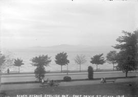
Beach Avenue English Bay, foot Davie St.
Part of Major Matthews collection
![[View of Pender Street, showing Elysium Hotel and partially constructed Hoffmeister Building]](/uploads/r/null/c/7/c7919d11d78a0293d3b28702c5a04303c5c1003a86ece94ec6a9f41d4103866f/59263702-91a9-45aa-93ba-4edad54a714d-A04629_142.jpg)
[View of Pender Street, showing Elysium Hotel and partially constructed Hoffmeister Building]
Part of Major Matthews collection
J.S. Matthews' notes with print or negative in Archives.
![[View of Pender Street, showing houses and partially constructed Hoffmeister Building]](/uploads/r/null/5/3/53b3359b3a3d6d5fecedc851fbb138b9e94cc648f0578955f52c853c200dbec0/6aa5f7b2-f3f4-4205-8b24-078dae8e7769-A04628_142.jpg)
[View of Pender Street, showing houses and partially constructed Hoffmeister Building]
Part of Major Matthews collection
J.S. Matthews' notes with print or negative in Archives.
![[View of Pender Street looking west, showing Elysium Hotel and Hoffmeister Bros. garage]](/uploads/r/null/7/c/7c9877c9fb8ea48ba89f03f5ea6a3e4b7daeaa06ab72d6bae3e8788650031982/83bdd937-86b3-4674-8cfe-12d6ce31d8b8-A04627_142.jpg)
[View of Pender Street looking west, showing Elysium Hotel and Hoffmeister Bros. garage]
Part of Major Matthews collection
J.S. Matthews' notes with print or negative in Archives.
![[View of Pender Street, showing houses and partially constructed Hoffmeister Building]](/uploads/r/null/2/1/2187c3d081a1c9b98d79ee33f35bce469db76002bd404e166012bfcf11bb2404/9f9ea905-997e-4fff-b9cb-83429e066e5f-A04626_142.jpg)
[View of Pender Street, showing houses and partially constructed Hoffmeister Building]
Part of Major Matthews collection
J.S. Matthews' notes with print or negative in Archives.
![[Two views of Melville Street covered in snow]](/uploads/r/null/8/c/8cd3069a7fb3198b32abedc608bbda2786d5925485ac0a93e889e9a8fc8f7005/82694b0c-b6a0-4d50-a8a4-a35800f641fe-A04624_142.jpg)
[Two views of Melville Street covered in snow]
Part of Major Matthews collection
Photograph negative is a copy of two photograph prints, each showing houses, trees and sidewalks covered in snow. J.S. Matthews' notes with print or negative in Archives.