
Meliden from Roundwood
![[View of Stanley Park causeway]](/uploads/r/null/1/4/1400cb0870559e653058060d461a4c40f2d71d31f5a272b7b5cc27f422df06ba/1012a3da-487c-41b2-97a3-2acab239d2bb-A71130_142.jpg)
[View of Stanley Park causeway]

[Lighted Ruddy-Duker Ltd. billboard advertising Turret Cigarettes at the south end of the Connaught (Cambie) Bridge]
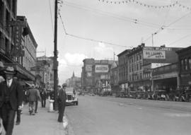
![[Hastings Street looking east towards Carrall Street]](/uploads/r/null/9/c/9c3feb0ced87b2319fda1fe3f70fc6cd921288e71d5f40f3bc22b775a7af79c5/9faeb503-d9c7-48c0-9c59-f678ffe8c89e-A20300_142.jpg)
[Hastings Street looking east towards Carrall Street]

View looking north on Main Street from a location close to East 6th Avenue
![Columbia [Street] and 4th [Street] east side incoming](/uploads/r/null/0/8/0877a01fcd6e325812d187db25cd79278a2a59680799f44283247f8bd6a0a033/2f7f3ff3-9772-4a56-96cd-8ec58ea50716-A20213_142.jpg)
Columbia [Street] and 4th [Street] east side incoming

Kingsway and Broadway northeast
![Main [Street] and 7th [Avenue] northwest city](/uploads/r/null/4/a/4a305692bfd29dc4d8a7e500a6df135345bac2aeed8c063fb5bd8573ed15a848/750520de-f6ec-42fb-9993-b4251907d831-A20234_142.jpg)
Main [Street] and 7th [Avenue] northwest city
![Main Street between 4th Avenue and 5th [Avenue] city](/uploads/r/null/4/4/445a23f4b03e999264be6a0b0fea77c5315c9aa646352e8dc0166174b7f4a13c/a997c042-3a0c-45d7-ab86-d4f3402fd4f1-A20237_142.jpg)
Main Street between 4th Avenue and 5th [Avenue] city
![Main [Street] and Terminal [Avenue]](/uploads/r/null/4/0/40b33d35a2eb97c93eea6737c21274e43ee32c92612dc67c319c186d869f6d06/c4ca45b5-8eaf-4a9b-8cdc-6bfabd29a4f4-A20239_142.jpg)
Main [Street] and Terminal [Avenue]
122 East Hastings Street - east wall
![Hastings [Street] and Campbell [Avenue] northwest](/uploads/r/null/2/6/26120c29ad2356b59d4ca6a6422a153784c8ad4191068352181fa682d1c7019e/190657a5-6e78-4c6f-b74a-9b19f7a85478-A20246_142.jpg)
Hastings [Street] and Campbell [Avenue] northwest
![Granville [Street] and 8th [Avenue] northeast](/uploads/r/null/9/3/93c35e9c7dc441a0f3031655685a3ccfe76cbf390212fe65258af5af97aaffb7/3339122d-eb80-45ba-80b4-d76258862c28-A20269_142.jpg)
Granville [Street] and 8th [Avenue] northeast
![Granville [Street] and 8th [Avenue] southeast](/uploads/r/null/2/8/28f86f8d65e6359750e91b8dfeaae6a6b8018fb0785ea1b04ee0ac349bf01bea/d177644d-5de5-49b1-bdbf-2a7a5c9a89a2-A20270_142.jpg)
Granville [Street] and 8th [Avenue] southeast
![Granville [Street] and 11th [Avenue] southeast](/uploads/r/null/2/f/2f1584d55787d78f0a0b1294b2b86a03fad9b109de49c06aa64817ec8cedd059/1298e27a-4c9e-4fd5-855b-561f784664ca-A20272_142.jpg)
Granville [Street] and 11th [Avenue] southeast
![Granville [Street] and 70th Avenue northwest city](/uploads/r/null/2/e/2e44446fbb17ccbadf36472369dd6013bc8bda8e26f0a8b1b5d0a793ffb17892/d3bfa824-61ed-4286-9696-527756eba8d7-A20273_142.jpg)
Granville [Street] and 70th Avenue northwest city
![Cambie [Street] and 2nd [Avenue] facing northwest](/uploads/r/null/a/4/a487590ab1aaa07e3403d87c275927901a8fb986725e95733e3b52f01c8a4df0/7b4ac595-0677-4988-8384-fd601251c684-A20278_142.jpg)
Cambie [Street] and 2nd [Avenue] facing northwest
![Cambie [Street] and 2nd [Avenue] facing southwest](/uploads/r/null/5/a/5a86d00b9eb08dc97ecb318f2b9841db4b24e7cef92c93151f7ed8885b9c372a/6dbcd7b9-9280-424c-9f0c-cb581d9f4892-A20279_142.jpg)
Cambie [Street] and 2nd [Avenue] facing southwest
![Cambie [Street] and 5th [Avenue] southeast](/uploads/r/null/7/f/7fbf991debed8f6c452410e7b4d303c415ef8ee708aaf0d63e9a4ca002903d58/04bcd99e-8d45-4e53-af03-4079827c56cf-A20280_142.jpg)
Cambie [Street] and 5th [Avenue] southeast
![Broadway and Arbutus [Street] northeast city](/uploads/r/null/5/5/555750b588503a3322ebf29c1e45da7a1aedbd6e38a7c4b9013e674c6803ab7b/46fd7cf5-0743-4c2c-ad40-aafc16a81898-A20281_142.jpg)
Broadway and Arbutus [Street] northeast city
![Broadway and Larch [Street] northwest city](/uploads/r/null/4/4/44bcc0702f4348115e8b9b92f0800af0ef18f9ad3cd78b82925de51b59bc4581/d6f90187-6d2e-427e-906b-f06f80d25716-A20282_142.jpg)
Broadway and Larch [Street] northwest city
![4th [Avenue] and Larch [Street] northeast](/uploads/r/null/c/9/c93c44f1bdb85311e4581ec681d14862ccc914d0f7bf1ca734ebf177c7889149/85903af6-7d8c-4308-8c11-4e39c6ac4dbc-A20284_142.jpg)
4th [Avenue] and Larch [Street] northeast
![Cedar [Street] and 3rd [Avenue] southeast](/uploads/r/null/2/4/24ecb31b8fb431ac107b04bad31b456a7681a6dff0f9a3d5ca79fee94bda8c45/be3dd63a-84f4-4661-b20b-3af672838c17-A20285_142.jpg)
Cedar [Street] and 3rd [Avenue] southeast
![Cornwall [Avenue] and Walnut [Street]](/uploads/r/null/1/2/12061a5e69986914a6c75fe76edaaa3b2d189e5e002e10fe897246884b3a196a/08e141a2-892a-462b-8234-18d903319936-A20286_142.jpg)
Cornwall [Avenue] and Walnut [Street]
![[Lighted Ruddy-Duker Ltd. billboard advertising Modernize Electric Ranges]](/uploads/r/null/4/4/44e8778ff3f8f59bf954c36b850c8d06a53cfddc4073e75fd7c716539b723925/149b3768-eec6-4c42-ad47-00605f8481eb-A20288_142.jpg)
[Lighted Ruddy-Duker Ltd. billboard advertising Modernize Electric Ranges]
![[View of Oxford College and the University Church of St Mary the Virgin from High Street]](/uploads/r/null/f/1/f164212192dc68944a248fb5d36256a83101001766d3c9021814b461ec64b118/ba58fa64-61f2-47ae-91f8-6456bdc2544a-A19729_142.jpg)
[View of Oxford College and the University Church of St Mary the Virgin from High Street]
![[Unidentified American city]](/uploads/r/null/6/4/64f366831e5bf7e968fb78fecba8be78803e6835349ea3e82333d6260ce3812d/01160494-6a5c-4589-a9a0-b92eaf2cfb96-A19756_142.jpg)
[Unidentified American city]
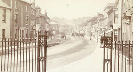
Hart Street and Market Place
![[View of Phoenix Square, Fredericton]](/uploads/r/null/0/0/007aed5feb4fae05808d1ae651c8e9c4cc036e3527ba934b84bf21263f61a32d/988171e2-ecae-4a8b-8360-601ecb053fce-A19759_142.jpg)
[View of Phoenix Square, Fredericton]
![[View of an intersection on Kingsway]](/uploads/r/null/c/f/cfe400afd470037c32921b61c3e288beb498141a4ed40bba8a293220e8bfdf44/71808117-63ec-4d3d-a3fc-57f737009105-A19334_142.jpg)
[View of an intersection on Kingsway]
![[View of intersection probably River Avenue, now Marine Drive, and Fraser Street]](/uploads/r/null/6/4/6452707075abe1664e358d730eaeb4c51f71f6ce92a5dd0e0f63dfe4efc6b183/2af5de23-d671-4a66-bcb0-386ae624da78-A19355_142.jpg)
[View of intersection probably River Avenue, now Marine Drive, and Fraser Street]
![[View of the] Main St. bog [between 33rd Avenue and 41st Avenue]](/uploads/r/null/7/f/7fb80b09ebfd64e91e42bdfb033c7901f4187e4e47fb8a675f55ecce664255be/0d0df890-2794-44d1-b878-b21f154e60b1-A19256_142.jpg)
[View of the] Main St. bog [between 33rd Avenue and 41st Avenue]
![[View of finished] Paving Main St. and 17th Ave. looking north [showing the Winram block]](/uploads/r/null/5/b/5bac016b96314bbeb917b4e377d1ee1841c46536089bb447fecfdd79e090d3ee/b572beb9-fb07-4eb5-bda9-9431a294e603-A19258_142.jpg)
[View of finished] Paving Main St. and 17th Ave. looking north [showing the Winram block]
![[View of] Main St. and 51st Ave. looking north](/uploads/r/null/f/8/f883edec5ff5f43b5a87451c288ebdd8ac155bbc70a6da73860b2397d6cd3d41/ba858f93-e41e-4f01-b6e1-113768409322-A19260_142.jpg)
[View of] Main St. and 51st Ave. looking north
![[View of] 56th Avenue](/uploads/r/null/5/e/5e6e63808539d76e2bb1611fb7f58e19d6ff2f5c79c8c0fb9a41ae096f1041e3/c876d1dc-483f-4911-be0a-4ea8219a7537-A19232_142.jpg)
[View of] 56th Avenue
![[Horse and cart travelling along 34th Avenue (now 33rd Avenue) before paving]](/uploads/r/null/5/8/58accbe9066b3a5afac554e1ad18cdf02097c9d7ed41cdcb5fd1f274eecd26dd/9e97a0b1-fb21-43e0-bdb6-846e105fa9f6-A19268_142.jpg)
[Horse and cart travelling along 34th Avenue (now 33rd Avenue) before paving]
![[Street car outside the Winram Block, 17th and Main St.]](/uploads/r/null/e/1/e14e644a588b3f93678f4c964d20100150b12ddfe3bf74e33850981e29b76c8b/a52e4081-8f51-4943-a4c5-3fadd9085e6b-A19271_142.jpg)
[Street car outside the Winram Block, 17th and Main St.]
![[View of a dirt road, possibly 33rd Avenue, with street car tracks along one side]](/uploads/r/null/c/6/c64e9d504cc9b533bf0c5d0399db85273e1137fd7e3945aa2e84aa82a215b053/db19eae9-2562-40d9-9249-b36cc0c36f0b-A19282_142.jpg)
[View of a dirt road, possibly 33rd Avenue, with street car tracks along one side]
![[Horse and cart travelling along] 34th Avenue [now 33rd Ave.] before paving](/uploads/r/null/1/b/1bea09e65d46b4109283423d33373961bada71fdd08bf41e25c639f1387eb3a6/ec202a7a-9fdb-4901-9fe9-d5885081dc3d-A19285_142.jpg)
[Horse and cart travelling along] 34th Avenue [now 33rd Ave.] before paving
![[View of] 34th Ave [now 33rd Ave] showing bitulithic paving](/uploads/r/null/1/5/15414121a12f5fa073fca9e2c5389404bfae71a44dd49b8a52e6efc7ea4096d9/38ff3049-ffb8-490e-ba3d-9b6da6192256-A19286_142.jpg)
[View of] 34th Ave [now 33rd Ave] showing bitulithic paving
![[View of road paving at the] Intersection Main St. and 34th Ave. [now 33rd Avenue]](/uploads/r/null/e/b/eb7cbb6633178207f5f6cba577f32455439dead88a072ac334180ac063701e1a/ee3c2d88-476a-4a4c-b0c8-13120cd63792-A19287_142.jpg)
[View of road paving at the] Intersection Main St. and 34th Ave. [now 33rd Avenue]
![Finished bitulithic pavement Fraser St. and 34th Ave. [now 33rd Ave.]](/uploads/r/null/c/e/ced8cd4412754133f7d8b463ccd8ac13af0a8edf3f6aa85b1badc6e4af86de92/2bf50e3c-64a8-4efa-b475-59422ab6f306-A19292_142.jpg)
Finished bitulithic pavement Fraser St. and 34th Ave. [now 33rd Ave.]
![[View of 33rd Avenue showing road work in progress]](/uploads/r/null/b/3/b3d6aa7eb8fb0bf11bef829f4930510c09435ec0ead8048f44cfbf1708600abf/b1595b8e-b135-4c1d-a4e8-8737f2850cd0-A19297_142.jpg)
[View of 33rd Avenue showing road work in progress]
![[Houses in South Vancouver]](/uploads/r/null/9/6/96beb114cdd36eb0925112d2fd5239b964d9de446cf79bd3c538c89ef082f0b8/090fc4d6-bd26-46bc-835f-1b2282ac15df-A19300_142.jpg)
[Houses in South Vancouver]
![[Surveyors on street in South Vancouver]](/uploads/r/null/b/0/b09502a2af3b99222d80fd5668c89eb6ad7f009934c53dd430cadad418ffe532/5b53049e-48db-4876-9ec4-b4adcbb0e6e0-A19303_142.jpg)
[Surveyors on street in South Vancouver]
![[View of Joyce Street looking south west towards Carleton School]](/uploads/r/null/6/5/65fddfb53fec807e9ed3476cea8eed909270066ae00a0cc4c69987f1c05de56e/5da90945-5972-46b9-8b35-bd078632aec3-A19313_142.jpg)
[View of Joyce Street looking south west towards Carleton School]

Government Street - Victoria

Fort Street - Victoria
![Lytton B.C. - Frazer [Fraser] River](/uploads/r/null/1/a/1a476318c531e1a5ab3193afe22d81e9415b54f8c1a7db1e5fbc10524f9fafbe/8e4ee711-cbd1-45ea-adc6-b1cca922086b-A22920_142.jpg)
Lytton B.C. - Frazer [Fraser] River

Village of Esquimalt