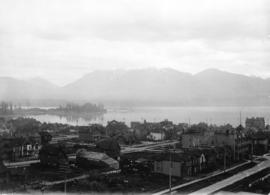
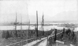
![[View looking east from Vancouver Heights]](/uploads/r/null/a/e/ae2d1e08e7ff32102f9409bf50e1aa27bf5457e4ca1abc99da9d14839a7b37ab/261a2e6d-e08e-42e6-a562-b331578b1de3-A09867_142.jpg)
[View looking east from Vancouver Heights]
- AM54-S4-: Van Sc N74.1
- Item
- [1924]
Part of Major Matthews collection
Photograph shows a dirt road through a bushy area and a view of a portion of Burrard Inlet.
220 results with digital objects Show results with digital objects
[View looking east from Vancouver Heights]
Part of Major Matthews collection
Photograph shows a dirt road through a bushy area and a view of a portion of Burrard Inlet.
![[View looking north from Vancouver Heights]](/uploads/r/null/d/0/d01f859748c2b49b352f6675548a9d5540240cb13dc8ce91f08489f51ba0deeb/81538f27-a410-4155-bffa-e67b2d2383e6-A09868_142.jpg)
[View looking north from Vancouver Heights]
Part of Major Matthews collection
Photograph shows dredging equipment and log booms in Burrard Inlet, a dirt road in front of a yard and forest and mountains in the background.
![[Two panoramic views of the Vancouver waterfront]](/uploads/r/null/e/b/ebb8a0175631b7ca1eaa5df8c8baab74bf9dbc9b44771c1d857a6d47f7c84116/bb0340eb-8273-4fb6-a889-d5c833bba631-A09871_142.jpg)
[Two panoramic views of the Vancouver waterfront]
Part of Major Matthews collection
![[Two panoramic views of the Vancouver waterfront]](/uploads/r/null/9/f/9f9d917ad98a3cd07e31e8ee76935130c07ca4abfc2c124763f3dbc327f613d4/83db4ead-2884-40a3-9a96-aabab13b18f8-A09872_142.jpg)
[Two panoramic views of the Vancouver waterfront]
Part of Major Matthews collection
![[Two panoramic views of the Vancouver waterfront]](/uploads/r/null/1/b/1bec66f804a67f66ddb05a02ad6dee9e26a57a5fcc9d3ceca660bd7feea67c75/e0b3328f-9b94-4291-ab63-16083f462a64-A09873_142.jpg)
[Two panoramic views of the Vancouver waterfront]
Part of Major Matthews collection

Part of Major Matthews collection

First Avenue Viaduct - Dominion Construction Company Limited, Contractors
Part of Major Matthews collection
Construction progress photograph

Vancouver from Hotel Vancouver
Part of Major Matthews collection
Photograph shows a northwestern view including part of the west side of the 600 Block Howe Street and Deadman's Island in the background
![[Northeast aerial view of Burrard Inlet and Vancouver]](/uploads/r/null/6/6/662502a43d6839b8b0b3518a2f22ca5822fc6dc224c73d5002c705655d5ab329/48aa6304-734e-41ed-8ef2-daffdac1a38d-A23488_142.jpg)
[Northeast aerial view of Burrard Inlet and Vancouver]
Part of Major Matthews collection
Oblique view
![[View looking north from the Hotel Vancouver]](/uploads/r/null/6/4/64b11d9c89a741706ebda07c14cbe1bc9ddece32caf48e09dbd64d52e2f5720a/3a282884-5eb4-435d-8e82-9e8a07c575a5-A23504_142.jpg)
[View looking north from the Hotel Vancouver]
Part of Major Matthews collection
Photograph shows the Marine Building
![[View of Fairview looking north-west]](/uploads/r/null/b/8/b890c9794a5cc39f7be965d287b974abdbc0b3471106801fc91b109db2c3f5d7/15a9e9cc-16d2-4d24-a10b-08e0af9c6892-A23512_142.jpg)
[View of Fairview looking north-west]
Part of Major Matthews collection
![[View of Downtown and the waterfront looking north-east]](/uploads/r/null/6/c/6cff1e9ae582d985f97bb1d48994ec74d160cab5ed6f69ae8f590dd682ad09fd/e7b10570-966f-4553-a7d1-b8b1e1f9788b-A23513_142.jpg)
[View of Downtown and the waterfront looking north-east]
Part of Major Matthews collection
![[View across Burrard Inlet toward English Bay from the foot of Trafalgar Street]](/uploads/r/null/6/3/63dcc142e99746062de179b6facfab6fccd8a86241823bbab31d3191a9b5b7c3/c30444a3-8e5d-41dd-b170-5eb3a69913df-A23675_142.jpg)
[View across Burrard Inlet toward English Bay from the foot of Trafalgar Street]
Part of Major Matthews collection
![[Looking north across False Creek from 33 Dufferin Street (East 2nd Avenue)]](/uploads/r/null/1/0/101be9bf6104e3403df3afa6eb0d415584ada39cdff22b13acda8e3b4ff039b7/8f920a96-a3ad-4f39-9e59-636a9cad123b-A25215_142.jpg)
[Looking north across False Creek from 33 Dufferin Street (East 2nd Avenue)]
Part of Major Matthews collection
Photograph shows the Westminster Bridge, Bridge Hotel, the East End School and other buildings in the background
Part of Major Matthews collection
Photograph shows the west side of the 600 Block of Howe Street including Manor House
![[View of the east side of the 600 Block Granville Street from the Hotel Vancouver]](/uploads/r/null/4/4/4425fb6fbb80b3749d053a61cd527c8178e50eaf7d19c06fe5a29423a3c99305/2fb46c95-d5cb-4300-9fe9-8e29cae87b74-A25789_142.jpg)
[View of the east side of the 600 Block Granville Street from the Hotel Vancouver]
Part of Major Matthews collection
Photograph shows the Hudson Bay Company store, the New York Block and the roof and spire of the Homer Street Methodist Church
!["A Glimps[e] of Home"](/uploads/r/null/e/1/e1aee444c652d9240fb82cd8f78a20e7eafd5572dbec940cf6e27fa805b39537/95f32826-bc87-4505-a782-3a20b4dc4441-A25883_142.jpg)
Part of Major Matthews collection
Photograph shows a view of the West End from Kitsilano Point
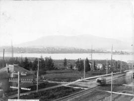
![[Fairview looking west across False Creek]](/uploads/r/null/5/3/530c1602976afb68dba7c39f098a0a2dd5b251f4f37cb95836fc30f1f5877280/8ef64e7f-ca79-41ee-b3cc-070bc0f90b28-A25939_142.jpg)
[Fairview looking west across False Creek]
Part of Major Matthews collection
Panoramic view showing the False Creek Indian Reserve, Granville and C.P.R. Kitsilano Trestle bridges and Edward Chapman's residence.
![[View of West End and Yaletown from Fairview]](/uploads/r/null/9/9/99ae5cc2d1ce7b9eb63e0a0c4e048e130b8ee84a4cf7c81a038f3b77fb749b71/322c7cf7-a463-4e23-a0cb-3ce4a74ffc61-A25940_142.jpg)
[View of West End and Yaletown from Fairview]
Part of Major Matthews collection
Panoramic view
![[Eastern view of False Creek from Fairview]](/uploads/r/null/4/2/4277723ceb6aa63994df422f6ded5892cf22f11b860a78157db74acd5abe5048/913f6e38-fc88-4795-b030-030ec68a5f8a-A25941_142.jpg)
[Eastern view of False Creek from Fairview]
Part of Major Matthews collection
Panoramic view showing the Connaught and Westminster Avenue bridges.
![[View of Vancouver at night from Grouse Mountain]](/uploads/r/null/9/2/9201c5d78707646140eb00dbbf7703f6c2c19fb72b120f4dc09288fb63e14f4a/8eda7534-9bb3-4ceb-89f1-ddf3e57eb223-A32827_142.jpg)
[View of Vancouver at night from Grouse Mountain]
Part of Major Matthews collection
![[View of a heron's nest in Stanley Park]](/uploads/r/null/6/c/6c151d67bd15a3d5c5bce4b4911c9f4a619723710689cf081d726d3217d19600/533d9c4e-f176-4226-a10c-cd9ec2bc6cad-A34234_142.jpg)
[View of a heron's nest in Stanley Park]
Part of Major Matthews collection
![[View of Deadman's Island across Coal Harbour from the foot of Cardero Street]](/uploads/r/null/5/6/56d8d0b586b06e59ff28fd3d94a2c551a0133573d8b69e4a4786080727097739/3e5a82d0-ea5e-4593-b4f5-89ba3654cfe6-A36274_142.jpg)
[View of Deadman's Island across Coal Harbour from the foot of Cardero Street]
Part of Major Matthews collection
![[Looking east across Coal Harbour from the foot of Cardero Street]](/uploads/r/null/e/8/e81ed82ea275c71149094386b3048cfe85af88e4c950d2dbfd8fa3b089c394c9/7d237c33-2bf0-4f87-afe6-e277ee46d3b5-A36275_142.jpg)
[Looking east across Coal Harbour from the foot of Cardero Street]
Part of Major Matthews collection
Photograph shows British warships at anchor

Part of Major Matthews collection
![[View of Lord Roberts School from the corner of Davie Street and Cardero Street]](/uploads/r/null/d/c/dcb35a1971ab94bb28b39ad66936cd399d259b48f014b86732fff2bd8ccbc631/f04d98d2-2cce-400f-a91e-12f6aeac1f08-A36984_142.jpg)
[View of Lord Roberts School from the corner of Davie Street and Cardero Street]
Part of Major Matthews collection
Photograph shows street car tracks
![[View of Hastings Street looking east from the Dominion Trust Building at Cambie Street]](/uploads/r/null/d/0/d0dd32f9b531ffbbf6380d33748b4f864a7696010f6dde764d14b173f1c814d1/43eac0cc-fd93-4586-8bdf-bf7d6315968d-A36992_142.jpg)
[View of Hastings Street looking east from the Dominion Trust Building at Cambie Street]
Part of Major Matthews collection
Photograph shows the Great Northern Railway Bridge, the C.P.R. yards and other waterfront buildings in the background
Part of Major Matthews collection
![[View of Westminster Avenue (Main Street) from Mount Pleasant]](/uploads/r/null/7/2/72164daee254e324f7476d22e953b4c596d97e499c99e22e67a7c705e96d6ad0/d625217a-35e2-4766-8602-e72e43506457-A37017_142.jpg)
[View of Westminster Avenue (Main Street) from Mount Pleasant]
Part of Major Matthews collection

Part of Major Matthews collection
Photograph shows a view from the corner of Georgia Street and Granville Street including the Hudson Bay Company Store, the Bank of Montreal and the spires of Holy Rosary Cathedral
![[Looking west from Hastings Street at Homer Street]](/uploads/r/null/2/9/29abb74e32c963290c521b4a28613197d4785a05f157c6ff179008f757b9d47b/8452c22a-3ebd-431c-a86b-5e427ebff3d9-A37026_142.jpg)
[Looking west from Hastings Street at Homer Street]
Part of Major Matthews collection
Photograph shows Holy Rosary Cathedral
![[View of tree stumps from the corner of 12th Avenue and Crown Street]](/uploads/r/null/1/0/10db0a355bc50b7670dcf26ac1bba1db18d84f2d30ef6fcf9c3fb661ff5e2db5/f678c38d-0183-44f4-8edb-9f502a5fa84b-A37076_142.jpg)
[View of tree stumps from the corner of 12th Avenue and Crown Street]
Part of Major Matthews collection
![[View of tree stumps from the corner of 12th Avenue and Crown Street]](/uploads/r/null/b/4/b46306b5ca9bd13516353852a316fa079419824de41937d89065c29c0992a1ea/4c0f1f5c-1305-477e-84e5-b06450f49f67-A37077_142.jpg)
[View of tree stumps from the corner of 12th Avenue and Crown Street]
Part of Major Matthews collection
![[Looking south across False Creek from Hamilton Street and Robson Street]](/uploads/r/null/f/b/fbe06b66c9466b7b0d3b9b5ecd6ff870225ca2e783b16af2327f55a49d950914/bd074e06-7935-4238-87a0-1fa1e0f8fac8-A37083_142.jpg)
[Looking south across False Creek from Hamilton Street and Robson Street]
Part of Major Matthews collection
![[Looking north near Centre (Granville) Street from Ninth Avenue (Broadway)]](/uploads/r/null/8/d/8d659bc5d10e183c5ff6d01732829796801d5b033fcb5da1a9722a00005f5b44/bf08d760-4da7-4fee-a5bd-0f10db8dc41e-A37097_142.jpg)
[Looking north near Centre (Granville) Street from Ninth Avenue (Broadway)]
Part of Major Matthews collection

Looking across the Inlet from Hotel Vancouver With The Season's Greetings
Part of Major Matthews collection
Photograph shows a view of the 600 Block Howe Street looking northwest from Georgia Street including the Walker and Robinson Nursery, tennis courts and Manor House
![[View of Vancouver before the fire from a clearing at Hastings Street and Granville Street ]](/uploads/r/null/4/e/4e3aeb1c069ffe5b1be2c199fd1b6a8b2aa0c2c85faa59262a79f7bdbf58fa61/831c1567-8a7a-4300-915f-6742f85fb61f-A37166_142.jpg)
[View of Vancouver before the fire from a clearing at Hastings Street and Granville Street ]
Part of Major Matthews collection
![Mount Pleasant from Westminster Avenue [Main Street]](/uploads/r/null/f/d/fd63732153071da448f488eeeb7356a09daea078b636833e3dca2840c26e6eef/75ec8c28-e1b8-47c5-8888-3ffdb25aa589-A37171_142.jpg)
Mount Pleasant from Westminster Avenue [Main Street]
Part of Major Matthews collection
Photograph shows the Westminster Avenue Trestle Bridge looking south across False Creek
![[View of Fairview looking north from approximately 15th Avenue and Wolfe Avenue]](/uploads/r/null/e/a/eaab56faf0a7b092c1ac2f048adeb38e5f96c84432579614999510acdc002f6b/67ead65e-0e9b-403c-a1c7-ba225e406161-A37252_142.jpg)
[View of Fairview looking north from approximately 15th Avenue and Wolfe Avenue]
Part of Major Matthews collection
![[The Coal Harbour bridge and Stanley Park from the foot of Denman Street]](/uploads/r/null/a/1/a1bf05bebdf6fb8514abdfe8611f2b0337fdceed37a071380f3bb7e8f7ffee09/3be9fbcd-5036-4469-86ae-1becd3c3e31d-A37355_142.jpg)
[The Coal Harbour bridge and Stanley Park from the foot of Denman Street]
Part of Major Matthews collection
![[People watching boats in Coal Harbour from the foot of Denman Street]](/uploads/r/null/f/3/f387e40367d782d42819f3f63c736169ab9a26f94ab6d609702e954a24818967/4df6c6ba-7230-4fd0-a791-4e5b6b52d3e5-A37356_142.jpg)
[People watching boats in Coal Harbour from the foot of Denman Street]
Part of Major Matthews collection
Photograph shows the Coal Harbour bridge

Georgia Street Vancouver, B.C.
Part of Major Matthews collection
Oblique view looking east along Georgia Street from Broughton Street showing the Felix Apartments on Jervis Street, The Hotel Vancouver, Christ Church Cathedral and other buldings
![Vancouver, B.C. [from the air looking east from Lost Lagoon]](/uploads/r/null/5/1/5127fcacb95395f95ba7c0f104a40a408b7f3d76e10c9881ebcc71cfc1a7c5de/ee54b68d-1f24-417f-b491-0956e3d4522f-A42965_142.jpg)
Vancouver, B.C. [from the air looking east from Lost Lagoon]
Part of Major Matthews collection
Oblique view showing the Denman Arena, the Horse Show building, the Coal Harbour waterfront and the West End

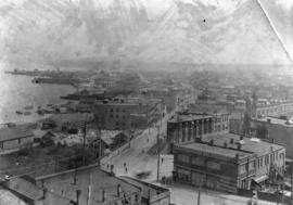
Vancouver from Hastings Street
Part of Major Matthews collection
Photograph shows a northeast view from Richards Street
![[Aerial view of the piers on the waterfront of] Vancouver, B.C.](/uploads/r/null/2/0/20aba7c72fbaff48163c905a081b26e279ffb5c8bb90db511f18e1662152abb5/aeaa6a64-f52b-4521-a874-dcce97de484f-A43206_142.jpg)
[Aerial view of the piers on the waterfront of] Vancouver, B.C.
Part of Major Matthews collection
Oblique view looking east from Coal Harbour showing fuel tanks, the C.P.R. piers and other docks and the Marine Building
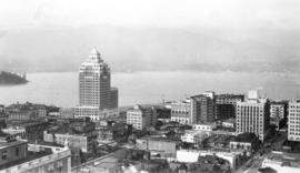
View from Roof Garden, Hotel Vancouver, Vancouver, B.C.
Part of Major Matthews collection
Photograph shows a view looking north including the Marine Building

Vancouver, B.C. from Hotel Vancouver
Part of Major Matthews collection
Photograph shows a view looking east from Georgia Street towards the 600 Block Seymour Street
![[Looking northwest from the Hotel Vancouver on the corner of Granville Street and Georgia Street]](/uploads/r/null/9/b/9bc7b31467f04c66440a23b6ad44d02934b3756b8e0dda107f815f6656f91e37/d52fede5-4254-4096-aaba-a44a1b3957c5-A43212_142.jpg)
[Looking northwest from the Hotel Vancouver on the corner of Granville Street and Georgia Street]
Part of Major Matthews collection
Photograph shows a view of the west side of the 600 Block Howe Street and beyond
Part of Major Matthews collection
Photograph shows a northern view of Mount Pleasant and False Creek from Westminster Avenue (Main Street) and 7th Avenue and a streetcar
Vancouver, B.C. from the South
Part of Major Matthews collection
Photograph shows a view looking north from the corner of Westminster Avenue (Main Street) and 7th Avenue including the Westminster Avenue Trestle Bridge and False Creek in the background