[Wilfred Cornish, Muriel Cornish, and Ethel Tait on Marpole Bridge]
[Westward view of Burrard Inlet from the Second Narrows]
[Westminster Avenue bascule bridge]
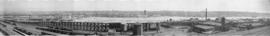
Western Canada Shipyards.Ltd. July 19-1917 [, False Creek]
[Western Canada Shipyards, False Creek]
Western Canada Shipyards Ltd. July 31st 1917 [False Creek]
West half Granville Island before filling
[View of Western Canada Shipyard showing the Georgia Viaduct and downtown in the background]
[View of Vancouver from Mount Pleasant; woman standing on bridge in Stanley Park; C.P.R. wharf]
[View of the Second Narrows Bridge and high tension power lines]
[View of the reclamation of False Creek Flats showing the reconstruction of Main Street at the bascule bridge]
[View of the Lions Gate Bridge looking east from the Capilano River]
[View of the Lions Gate Bridge looking east from the Capilano River]
[View of the Lions Gate Bridge from Chaythoos, the site where Lord Stanley dedicated Stanley Park]
[View of the C.N.R. Station under construction and the completed G.N.R. (Union) Station] March.23.1918.
[View of the Burrard Bridge from Pacific Street near Thurlow Street]
[View of squatter's shacks on the southwest sides of the Burrard and C.P.R. Kitsilano bridges]
[View of squatter's shacks on the southwest side of the C.P.R. Kitsilano trestle bridge]
[View of sqatter's shacks on floats near the southwest side of the C.P.R. Kitsilano trestle bridge]
[View of Mount Pleasant from the Lee Block, Broadway and Main]
[View of King and Jardine sawmill at First and Ontario, False Creek]
[View of Granville Island (reclamation partially complete) from the top of the Granville Bridge]
[View of Granville Island from atop the north end of the Granville Bridge]
[View of Granville Island and the south shore of False Creek] Photo Taken June June 16-1916 Time. 11:37 Tide -1.2. Pacific Dredging Co. Ltd. Vancouver, B.C.
[View of False Creek looking west from the Granville Street Bridge]
[View of False Creek looking south showing Granville Island during reclamation and False Creek being dredged]
[View of False Creek Flats east of Main Street]
[View of False Creek Flats east of Main Street]
[View of Fairview and Mount Pleasant from the roof of City Hall, 12th Avenue and Cambie Street]
[View of east False Creek showing the C.P.R. Drake Street Roundhouse and coal trestle, and the Cambie Street Bridge]
[View of City Market and the Westminster trestle bridge]
[View of China Creek Gully]
[View of Burrard Street looking south from Pacific Boulevard at the Kitsilano Railway Trestle bridge]
[View of Burrard Street looking south from Harwood at the Kitsilano Railway trestle bridge]
[View of billboards at the north end of the Burrard Bridge]
[View looking south from the middle of the Burrard Bridge]
[View looking south from the middle of the Burrard Bridge]
[View looking south from False Creek] Photo Taken on June 1st 1916.Time 1140. Tide 0.4.
[View looking north from City Hall]
[View looking north along the Granville Bridge towards the Continental Hotel]
Vancouver, From C.P.R. Docks
Vancouver From The Lee Block. Corner Broadway and Main Street
Vancouver from the air looking north from over Little Mountain
Vancouver B.C. from Fairview
[Tugboat "Lorne" and "Pacific Gatherer" after knocking down a span of the Second Narrows bridge]
[Tugboat "Lorne" and "Pacific Gatherer" after knocking down a span of the Second Narrows bridge]
![[Wilfred Cornish, Muriel Cornish, and Ethel Tait on Marpole Bridge]](/uploads/r/null/4/1/419bc2d445077c29a63776eb2095c05a50b8e63737dce87dbab9c3282ec08452/b8730a05-f424-4137-add8-23d666039f70-A04496_142.jpg)
![[Westward view of Burrard Inlet from the Second Narrows]](/uploads/r/null/5/8/58d3be37aa6a251ea1e045c10094914b25e43c39b8a8fc1f867f9f173ac2f2e9/31f24963-5097-4e60-8721-fe3fada0e93b-A63180_142.jpg)
![[Westminster Avenue bascule bridge]](/uploads/r/null/9/c/9c8e8fc5780fc41da15634f3ce3118efeba91542083ee7509c54cf6d0f210cb8/04b969b6-3742-4f21-8da4-9370721a43de-A24424_142.jpg)
![Western Canada Shipyards.Ltd. July 19-1917 [, False Creek]](/uploads/r/null/e/9/e9fea77bb65bdc06b471b1e04d345620c6ddcdd9b652ed595a122f2eecb59a51/b945ee10-c695-45be-ad4e-5575d8754d09-A63953_142.jpg)
![[Western Canada Shipyards, False Creek]](/uploads/r/null/5/3/53d0a0e17c1710a62fbd39eaed21efd8d1773a33701bcceab1cc3c12366fc39c/020f20b5-8330-4847-81b0-3aac74b51033-A63958_142.jpg)
![Western Canada Shipyards Ltd. July 31st 1917 [False Creek]](/uploads/r/null/2/9/29a80cd018c637b9b551b9dcad1503e46128426e0820ca2f38073618a2864638/8810a033-1688-4180-a10e-795b5f02c6df-A63954_142.jpg)

![[View of Western Canada Shipyard showing the Georgia Viaduct and downtown in the background]](/uploads/r/null/2/1/21cf5dbde21c93ec26bd24f64ac132ddb4cb1e5343455192cf15e09c930e8709/a7f9cb67-a3aa-4b64-beeb-f7730ee338e7-A64131_142.jpg)
![[View of Vancouver from Mount Pleasant; woman standing on bridge in Stanley Park; C.P.R. wharf]](/uploads/r/null/e/1/e1c85c783bb0ce41e854ac0cd90ff28454b6aad113c9978149334788b806ff27/f448bfac-13b8-4997-bcec-d8a408ad77ad-A04390_142.jpg)
![[View of the Second Narrows Bridge and high tension power lines]](/uploads/r/null/c/d/cd7c3aec7b373e4b15cb6d1d5edb01630ead371efcf270ebacd9d23acaecb64e/79cad5c0-9dc5-4e5f-8130-751c33f6e500-A10306_142.jpg)

![[View of the Lions Gate Bridge looking east from the Capilano River]](/uploads/r/null/2/d/2d0c75f08252cd1915d2d28fbf1546fb95b42a3f095499f57d4b051b693505fd/cab29458-591c-4db0-ad57-861856eecbce-A09926_142.jpg)
![[View of the Lions Gate Bridge looking east from the Capilano River]](/uploads/r/null/8/5/85ba853fa973d639234a4af681cedab3ee387c15496a86fa385532c9fdb5adfe/e4cf9e75-35f8-4b1e-a76a-94b3390faf5e-A09927_142.jpg)
![[View of the Lions Gate Bridge from Chaythoos, the site where Lord Stanley dedicated Stanley Park]](/uploads/r/null/2/5/253fcff959bc0024660b96f279fa727fda4a22e2fe452805bc4e79c05ebc3149/5589252a-7532-4288-8bca-20fa18c3ba36-A10268_142.jpg)
![[View of the C.N.R. Station under construction and the completed G.N.R. (Union) Station] March.23...](/uploads/r/null/9/1/91f31ac31c2459d3528623bc164eaeb8b3e91ea9daed48f84ccf9e9fbd824f90/ccb6f531-0b4f-4624-aa35-c0841a2e973a-A62953_142.jpg)
![[View of the Burrard Bridge from Pacific Street near Thurlow Street]](/uploads/r/null/f/5/c/f5c4b5cd8e6d6316ba4112ac05f874e1c6c6a334f3f82a2921d6cfc8fea51fc8/d87a2798-5154-4d31-8aa8-2b0bb12df837-CVA371-2979_142.jpg)
![[View of squatter's shacks on the southwest sides of the Burrard and C.P.R. Kitsilano bridges]](/uploads/r/null/4/c/4c7e98c7c29adb73c8898d0529f6da39203eb98e561ce11448e90803f31a6029/59f2ac4b-e266-4b5d-9ab1-d229e90e1792-A25979_142.jpg)
![[View of squatter's shacks on the southwest side of the C.P.R. Kitsilano trestle bridge]](/uploads/r/null/4/7/4775a318701c431157865fa212238b9de007ccdd4498c655bd6f1955e100f8ee/3aa3f2e1-80a1-4f1b-bfe3-59ab40ca8126-A25985_142.jpg)
![[View of sqatter's shacks on floats near the southwest side of the C.P.R. Kitsilano trestle bridge]](/uploads/r/null/8/a/8a5f545c135a5371dc45d26f5cf9d8a9c251efb78199cdd7646d1ae2ca973a47/80c6b934-a66e-45b2-af27-20b031460e43-A25986_142.jpg)
![[View of Mount Pleasant from the Lee Block, Broadway and Main]](/uploads/r/null/b/1/b1a10591488c68f9a18122cfa8f608fad319fbfa89c13392ad025d4afb3764d6/e0494038-a598-4615-af30-8ee294062605-A61801_142.jpg)
![[View of King and Jardine sawmill at First and Ontario, False Creek]](/uploads/r/null/3/a/3af2e0538c2fa5e610426609436a195c45133a0a2488de0567d55b42293b5998/99a388e3-6d29-474e-80b0-fc40af7765ca-A63543_142.jpg)
![[View of Granville Island (reclamation partially complete) from the top of the Granville Bridge]](/uploads/r/null/9/6/96d6d8f1fa3c3c265993d58d7694dab19e96c14154062bbd2941d790457db371/98059cab-f1f8-4b41-8be1-84fe353976d4-A63479_142.jpg)
![[View of Granville Island from atop the north end of the Granville Bridge]](/uploads/r/null/f/d/fd1b7ba4991ced82ac4ee12f417925183d6d2cbeb9abbf70e0f16065c06e2d4f/766f1222-7e0b-4729-b3cc-e234e83c6dad-A63169_142.jpg)
![[View of Granville Island and the south shore of False Creek] Photo Taken June June 16-1916 Time....](/uploads/r/null/d/a/dae66577bb36f034685c15d32d46b11eaa76d9f1c446c133128786fcad6305b6/b909587a-3a78-40f4-8f42-21a9b6825b97-A63478_142.jpg)
![[View of False Creek looking west from the Granville Street Bridge]](/uploads/r/null/2/a/2a21238cb025ad231c9b442da1a5ab28defca2e88ed9ecc42c49bd65c9390a97/4bb0ab2b-ccab-409d-950d-3a0b141c6b19-A09894_142.jpg)

![[View of False Creek Flats east of Main Street]](/uploads/r/null/5/d/5d0a808a4da26519ee2390736b5c2eae8a157e0573957fb8f67b825a709d20b0/7a5da500-ffa2-4229-8459-c2aed940a8d5-A62328_142.jpg)
![[View of False Creek Flats east of Main Street]](/uploads/r/null/2/2/22ae18e3c70f3b175e8da170286e28bec8b9c5badf5f7209cd805214ba4c2778/0054a24e-3793-409f-a191-486d3c0e0479-A63167_142.jpg)
![[View of Fairview and Mount Pleasant from the roof of City Hall, 12th Avenue and Cambie Street]](/uploads/r/null/2/0/208e68631777759d5511724cf523f405aab570c60b1d072c6544c204a02ba55a/951a4b6a-e3a5-418c-820c-f6393e92282c-A63177_142.jpg)
![[View of City Market and the Westminster trestle bridge]](/uploads/r/null/3/e/3e37b739b3193435af835d194cdcb39ed2fbb6e5786331c60d7c048f1ac8bb2b/af63d042-f1a0-4a1c-bbe6-8cb964a45af1-A25738_142.jpg)
![[View of China Creek Gully]](/uploads/r/null/6/0/60491484db84fc2999dbd623e57052a8cf3333d3e62b4cc0856e7ab0b8d0f6a4/a84bf02b-7137-4192-874c-e35f9afc61bd-A60316_142.jpg)

![[View of Burrard Street looking south from Harwood at the Kitsilano Railway trestle bridge]](/uploads/r/null/2/e/2e21ff1f292a66ddda462f2abe0b233ce3d12644445617b26c7e6fb4a1cf6901/82c374e5-9012-42b6-a43f-0bb149f7a083-A09813_142.jpg)
![[View of billboards at the north end of the Burrard Bridge]](/uploads/r/null/0/8/08a42e2883497e2bbaec974791d0ea3501a0dd745eb60775ba4c7c34c67079a2/a15567f2-a2b1-48ce-8776-833765ee4cee-A20302_142.jpg)
![[View looking south from the middle of the Burrard Bridge]](/uploads/r/null/0/9/0946f16e1010656522f6b0b646bbdb8823fee1f97189842cfcc4a9b3ed0a8848/1213bf91-88c4-456b-97aa-95faba871f42-A20291_142.jpg)
![[View looking south from the middle of the Burrard Bridge]](/uploads/r/null/e/8/e87dc75f507bb7bf9c24693e74689e14ee69490b2aa7e63bfb4c0e3fb25bcf3a/482d03d0-14e1-47ce-9d2b-6f7c0aae3308-A20290_142.jpg)
![[View looking south from False Creek] Photo Taken on June 1st 1916.Time 1140. Tide 0.4.](/uploads/r/null/a/e/aed4784758988849388cd8a8825df6b5e02879445ce3fe8c0cd9d73201329ef0/67b3e89d-dcb9-450f-a95b-0008384c611d-A63476_142.jpg)
![[View looking north from City Hall]](/uploads/r/null/7/a/7a5cefae760823892740b59c0b38bbc5bd3272ce46ad037b620199ee82e0416c/eef32f5c-231c-4970-8973-c3324d2a90d1-A43290_142.jpg)
![[View looking north along the Granville Bridge towards the Continental Hotel]](/uploads/r/null/9/a/9ad9b43959bfac5892268daa60983d651f1eda935a7f3b64a61e029ce6cb1fbd/4a2fa44c-7f4e-41b9-911d-a15ccf2ac1be-A20303_142.jpg)


![[Subsidence on the Georgia viaduct]](/uploads/r/null/8/9/89bdf8c8671885336d8cffcaca84165683f0a3a821a98d12282bb2351e94c050/c0eb336d-efff-47d7-901d-f7b864671213-A24550_142.jpg)
![[Subsidence on the Georgia viaduct]](/uploads/r/null/6/f/6f9361a42eae745c7cfb418735cbd43990b51fa62ccde5f3b3b46300ac9f07cc/87adb9dd-bc53-427b-a757-1b909db03ceb-A24549_142.jpg)