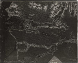
Showing 7 results

Archival description
Major Matthews collection Burrard Inlet (B.C.) Item
Print preview View:

6 results with digital objects Show results with digital objects

Burrard Inlet sheet II

Item is a copy of a portion of a manuscript map of Burrard Inlet, created during the H.M.S. Plumper survey of the area. Sheet shows the eastern portion of the Inlet, including the southern portion of the North Arm.

United Kingdom. Admiralty

Sko-Mish-Oath : the territory of the Squamish Indian People : Indian villages and landmarks : Burrard Inlet and Howe Sound before the whitemans came

Item is a print of a map by Major James Skitt Matthews, City Archivist, showing villages, landmarks and rivers of Howe Sound and Burrard Inlet using their indigenous names. The map also shows elevations and wildlife populating the area. It was compiled between 1931 and 1937, with the assistance of August Jack Haatsalano (Khahtsahlano), whose attestation is included on the map. Notes on the map explain the map's nomenclature.

Matthews, James Skitt, Major