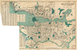
Wrigley's new revised map of Vancouver
- AM738-S1-: MAP 695
- Item
- 1947
Item is a street map of Vancouver, with a street index on the verso.
8 results with digital objects Show results with digital objects
Wrigley's new revised map of Vancouver
Item is a street map of Vancouver, with a street index on the verso.

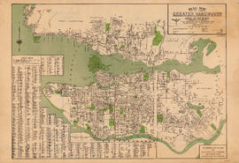
Item is a map of Greater Vancouver showing streets, parks, schools and hospitals; includes street index.
Item is a tourist brochure enclosed within a cover. The cover contains advertising for the Hotel Grosvenor. The enclosed brochure has information on the City, on the Hotel Grosvenor and on the Douglas Lodge (Fort St. James, B.C.), another property of the same owner. The reverse of the brochure is a road map of Greater Vancouver.

Map of Fraser Valley ; Street map of New Westminster ; Map of Greater Vancouver transit lines
Part consists of a street map of the Lower Mainland and Fraser Valley from Vancouver to Chilliwack, a street map of New Westminster, a map showing transit lines in Greater Vancouver, and text advertising the products and services of the Dominion Map and Blueprint Company.
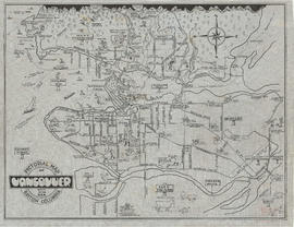
Pictorial map of Vancouver, British Columbia, city by the sea
Item is a pictorial map showing major roads and attractions in Vancouver, West Vancouver, North Vancouver, Burnaby, New Westminster, Sea Island and the northern portion of Lulu Island.

Dial map of Greater Vancouver and suburbs
Part contains a street map of Vancouver, West Vancouver, North Vancouver, and Burnaby showing railways, hospitals, parks and block numbers. The map includes the printed portion of the dial (a numbered circle, a grid of block numbers and a street index used to find locations), but no indicator is attached. A small inset shows the streets of Gleneagles in West Vancouver.

Transit system map of Greater Vancouver, B.C.
Part consists of a map showing trolley coach lines, bus lines, street car lines, interurban lines, interurban stops, route numbers, B.C. Electric installations and block numbers in West Vancouver, North Vancouver, Vancouver, Burnaby and the University Endowment Lands.
Dial map of Vancouver and suburbs
Part consists of a street map of Vancouver, West Vancouver, North Vancouver, and Burnaby. Part includes the printed portion of the dial (a numbered circle, a grid of block numbers and a street index used to find locations), but no indicator is attached.

Street map of Richmond, Langley, Coquitlam, Delta, Surrey, Pitt Meadows and Maple Ridge
Part includes a small inset map showing the city of New Westminster.
Dial map of Greater Vancouver and suburbs
Part contains a street map of Vancouver, West Vancouver, North Vancouver, and Burnaby. Map includes the printed portion of the dial (a numbered circle, a grid of block numbers and a street index used to find locations), but no indicator is attached.
Item is a street map showing Vancouver, West Vancouver, North Vancouver, and Burnaby on one side and Richmond, Langley, Coquitlam, Delta, Surrey, Pitt Meadows, and Maple Ridge on the other.
Item is a street map showing Vancouver, West Vancouver, North Vancouver and Burnaby on one side and the Fraser Valley and New Westminster on the other.
Item is a map and transit guide showing trolley coach lines, bus lines, street car lines, interurban lines, interurban stops, route numbers, B.C. Electric installations and block numbers in West Vancouver, North Vancouver, Vancouver, Burnaby and the University Endowment Lands one one side. The other side consists of three maps showing transit details in Richmond, New Westminster and downtown Vancouver, and descriptive information about B.C. Electric routes and services and Greater Vancouver attractions.
Item is a street map showing Vancouver, West Vancouver, North Vancouver and Burnaby on one side and the Lower Mainland from Vancouver to Chilliwack on the other. Item also includes information about bus services in Greater Vancouver and text advertising the products and services of the Dominion Map and Blueprint Company.
Item is a street map showing Vancouver, West Vancouver, North Vancouver and Burnaby on one side and the Lower Mainland from Vancouver to Chilliwack on the other. Item also includes information about bus services in Greater Vancouver and text advertising the products and services of the Dominion Map and Blueprint Company.
Sectional map and street directory of Vancouver : Dial map of the city of Vancouver
Item is a street map showing Vancouver on one side and Burnaby, New Westminster, Coquitlam, and parts of Port Moody and Port Coquitlam on the other, as well as text advertising the products and services of the Dominion Map and Blueprint Company.
Item is a street map showing Vancouver, West Vancouver, North Vancouver, and Burnaby on one side and the Fraser Valley, New Westminster, and Greater Vancouver transit lines on the other. Item also includes text advertising the products and services of the Dominion Map and Blueprint Company.
Item is a street map showing Vancouver, West Vancouver, North Vancouver, and Burnaby on one side and the Lower Mainland from Vancouver to Chilliwack, Richmond, and New Westminster on the other. Item also includes text advertising the products and services of Dominion Map and Blueprint Ltd.
Item is a street map showing Vancouver, West Vancouver, North Vancouver and Burnaby on one side and the Fraser Valley, New Westminster, Richmond, Delta, and Surrey on the other. Item also includes text advertising the products and services of the Dominion Map and Blueprint Company.
Sectional map and street directory of Vancouver : Dial map of the city of Vancouver
Item is a street map showing Vancouver on one side and Burnaby, New Westminster, Coquitlam, and parts of Port Moody and Port Coquitlam on the other, as well as text advertising the products and services of the Dominion Map and Blueprint Company.
Map shows boundaries, lot numbers and major roads in Greater Vancouver (including West Vancouver, North Vancouver, the City of North Vancouver, the City of Vancouver, Coquitlam, Point Grey, South Vancouver, Burnaby, New Westminster, Port Moody, Port Coquitlam, Pitt Meadows, Surrey, Langley, Delta and Richmond).