
- AM1376-: CVA 229-08
- Item
- 1909
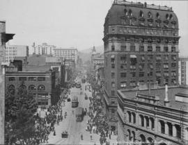
Item is a photograph showing a view of Granville Street looking north towards C.P.R. Station and North Shore Mountains.
17 results with digital objects Show results with digital objects
Item is a photograph showing a view of Granville Street looking north towards C.P.R. Station and North Shore Mountains.
Item is a photograph showing downtown Vancouver from English Bay with Beach Avenue and Jervis Street and the former Tudor Manor apartment building visible.
Aerial of Vancouver, B.C. [over False Creek]
Item is a photograph showing the Burrard Street Bridge, former train trestle and the West End neighbourhood as well as other parts of downtown.
Aerial shot from over Stanley Park
Item is a photograph showing Coal Harbour (left) and English Bay (right) and downtown buildings centre.
Item is a photograph showing downtown and boats in the harbour taken from Stanley Park.
![Granville Street [looking towards Robson Street]](/uploads/r/null/e/e/a/eea903b042f259aa6d941c1a003aaaa1fc95fddb720b155c6e41da1c67a2b2aa/3d105e31-257c-452f-a149-87b6897a7764-CVA220-05_142.jpg)
Granville Street [looking towards Robson Street]
![Hastings Street [at Granville Street, looking east]](/uploads/r/null/c/3/e/c3e0e80033bfc1abe619f2ef7c52c9335d199208a69ea9aa6a369120dc64089b/7e3916d1-d8a3-4f0b-9547-2d0c4ed09967-CVA220-11_142.jpg)
Hastings Street [at Granville Street, looking east]
![Hastings Street [looking towards Cambie Street intersection]](/uploads/r/null/3/2/1/321d1b6a2b28a3768524ccca75a7d5c5bf74fe813311eb2b0ec7a1b6e0d0dc32/2e33cb15-ca00-44d6-86f6-42cd3209f4e3-CVA220-10_142.jpg)
Hastings Street [looking towards Cambie Street intersection]
![Hastings Street [looking west to corner of Hastings and Granville Streets]](/uploads/r/null/a/1/4/a1413802d2e8896d75397a4e4edb6fee463593df335a949c3ea89543d5c901ce/9e41b343-61f9-4493-bbca-73e6d04bafc4-CVA220-06_142.jpg)
Hastings Street [looking west to corner of Hastings and Granville Streets]

Looking down Granville Street, Rogers Building on right, C.P.R. Station in distance
Looking west up Hastings showing Flack Block and Dominion Building
![New Wholesale District and Trackage [C.P.R. Yards on north side of False Creek]](/uploads/r/null/2/8/1/2819bed8116f32c62b81bbe6708dcffc17e41441a106e5835ae1622beb9d8a95/4f1bfcfe-ec00-4255-8309-7a23e6186f90-CVA220-12_142.jpg)
New Wholesale District and Trackage [C.P.R. Yards on north side of False Creek]
![Pender Street [at Hamilton Street with Odd Fellows Hall on left]](/uploads/r/null/5/2/a/52a20b6d9146aa06c3eac72931e4a1aac2db74932a6068b847fd074b5f57324b/901c2305-686b-4e21-931c-52936f8f4c3f-CVA220-08_142.jpg)
Pender Street [at Hamilton Street with Odd Fellows Hall on left]
[Rooftop view of downtown Vancouver at night]

Speedboat "Flying Cloud" in False Creek with cityscape in background

Speedboat "Flying Cloud" in False Creek with cityscape in background
Summer 1982 - Aerial shot from the south side of False Creek before Expo
Item is a photograph showing housing complexes along the south shore of False Creek and on the north side construction has begun for the Expo 86 site and BC Place Stadium is under construction, past the Cambie Bridge on the right.
View from downtown looking east
Item is a photograph taken from Harbour Centre [?] looking east at Water Street and East Cordova Street, following the waterfront up to around Dunlevy Avenue. Buildings visible include the Hotel Europe marking the intersection of Carrall and Alexander Streets, former Public Safety Building, and St. James Anglican Church.
[View from downtown looking southeast]
Item is a photograph taken from [Harbour Centre?] showing a view of downtown and the east end of False Creek around Main and Terminal Avenue. Photograph includes the Georgia Viaduct and in the foreground are buildings along Hastings, Pender, Cambie, Beatty Streets including the Sun Tower, Woodward's, the Dominion Building and part of Victory Square.

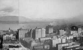
View looking north east over downtown Vancouver towards Burrard Inlet

View looking north over downtown Vancouver, across Burrard Inlet to North Shore
Item is a photograph taken from Harbour Centre [?] showing the north side of the False Creek in the foreground.
Item is a photograph taken from Harbour Centre [?] showing the downtown from Dunsmuir and Homer Streets, including the Beatty Street Drill Hall and former Canada Post office, the Georgia Viaduct and the north side of the False Creek in the foreground. The Cambie Street Bridge is centre, and the south shore of False Creek and City Hall and other buildings are visible in the background.
Item is a photograph taken from Harbour Centre [?] showing the downtown from Dunsmuir and Homer Streets, including the Beatty Street Drill Hall and former Canada Post office, the Georgia Viaduct and the north side of the False Creek in the foreground. The Cambie Street Bridge is centre, and the south shore of False Creek and City Hall and other buildings are visible in the background.

View of the Metropolitan Building, Marine Building and Immigration Building
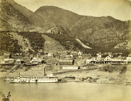
Photograph shows the paddle-wheeler "William Irving", the Railroad House, Caledonian Hotel, Steamboat Exchange, a church and other buildings
