
General View of Docks at Vancouver
- AM1376-: CVA 1376-375.18
- Item
- [1889 or 1890]
47 results with digital objects Show results with digital objects
General View of Docks at Vancouver
![[Wharf construction on the west side of the Westminster Avenue (Main Street) bascule bridge]](/uploads/r/null/f/e/fe4f36b1a9dc3cdc1024f2d391912d3852101f81cddfbdd4354d994a25864bb2/0c4acfbd-948f-475e-9aa4-794340d0e493-A45848_142.jpg)
[Wharf construction on the west side of the Westminster Avenue (Main Street) bascule bridge]
Photograph shows part of the G.N.R. trestle bridge, a utlity pipe going into False Creek and warehouses for McNeill, Welch and Wilson Building Supplies and Jingle Pot Coal and Downtown in the background

Wharf construction on the west side of the Westminster Avenue (Main Street) bascule bridge
Photograph shows the G.N.R. Trestle Bridge and Downtown and the Sun Tower in the background
![[Looking southwest from under the Westminster Avenue (Main Street) bascule bridge]](/uploads/r/null/b/8/b885463ec95e71f934fc72c32f1bc5c4a42b922100d067ce19a5ecd79d64a39c/564dbd8d-265a-42fe-9293-e2c34af49b16-A45841_142.jpg)
[Looking southwest from under the Westminster Avenue (Main Street) bascule bridge]
Photograph shows part of the swing span of the G.N.R. Trestle Bridge, a utlity pipe going into False Creek and warehouses for McNeill, Welch and Wilson Building Supplies and Jingle Pot Coal in the background
![[Wharf construction on the west side of the Westminster Avenue (Main Street) bascule bridge]](/uploads/r/null/a/f/afc7c718a03306a0c3de2129bee38af9e307a13e829601932bb68a1daca84313/2810e462-898d-415e-9502-6c33b45dd0af-A45845_142.jpg)
[Wharf construction on the west side of the Westminster Avenue (Main Street) bascule bridge]
Photograph shows the G.N.R. Trestle Bridge and warehouses for McNeill, Welch and Wilson Building Supplies and Jingle Pot Coal in the background
![[Looking southwest from under the Westminster Avenue (Main Street) bascule bridge]](/uploads/r/null/c/9/c9b73cedc57874652643fe8035e9aa20aac9cc1cf7c10327a8887caefb74d15f/48d1f3e7-b8b7-4b8c-91a1-29f78d73d09c-A45844_142.jpg)
[Looking southwest from under the Westminster Avenue (Main Street) bascule bridge]
Photograph shows part of the swing span of the G.N.R. Trestle Bridge, a utlity pipe going into False Creek, part of Market Hall and warehouses for McNeill, Welch and Wilson Building Supplies and Jingle Pot Coal in the background
![[Wharf construction on the west side of the Westminster Avenue (Main Street) bascule bridge]](/uploads/r/null/a/c/ac75fbfcaf7f7257a3b73697c03af06ef1665d31f19d0cfa4783f2736cf0de76/53beef9b-4089-4eda-8ab0-2bc390e5d6b6-A45849_142.jpg)
[Wharf construction on the west side of the Westminster Avenue (Main Street) bascule bridge]
Photograph shows the swing span of the G.N.R. trestle bridge, a utlity pipe going into False Creek and Downtown in the background
![[Wharf construction on the west side of the Westminster Avenue (Main Street) bascule bridge]](/uploads/r/null/a/6/a61ecf99279bb06a4bc0462df4c3ff46286e2b3f5f1b0bd8a1b22d80a608f6a7/9efe8447-bb85-4b7e-9e78-1dfc86440c66-A45847_142.jpg)
[Wharf construction on the west side of the Westminster Avenue (Main Street) bascule bridge]
Photograph shows the bascule and Downtown inluding the Sun Tower and Hotel Cunningham in the background
![[Looking west from under the Westminster Avenue (Main Street) bascule bridge]](/uploads/r/null/7/9/7982dd5b061cbb906f0125c681882a65972938737ab49769e5276b2d0be9e45c/bcaea93b-8c92-4eee-bad2-71e6313ae7ea-A45840_142.jpg)
[Looking west from under the Westminster Avenue (Main Street) bascule bridge]
Photograph shows swing span of the G.N.R. Trestle Bridge and a utlity pipe going into False Creek

Looking southwest from under the Westminster Avenue (Main Street) bascule bridge
Photograph shows part of the swing span of the G.N.R. Trestle Bridge, a utlity pipe going into False Creek and warehouses for McNeill, Welch and Wilson Building Supplies and Jingle Pot Coal in the background

Looking southwest from under the Westminster Avenue (Main Street) bascule bridge
Photograph shows the swing span of the G.N.R. Trestle Bridge, a utlity pipe going into False Creek, and warehouses for McNeill, Welch and Wilson Building Supplies and Jingle Pot Coal in the background

Wharf construction on the northwest side of the Westminster Avenue (Main Street) bascule bridge
![[Lions Gate Bridge]](/uploads/r/null/7/f/7f7190d56f4bd8bf0972aeced27ba2ce97b4b24e81cd381c5828145190a9c709/f04dd381-881d-4644-8cb0-2c49a0ac360f-A37749_142.jpg)
![[View of the suspension bridge in Capilano Canyon]](/uploads/r/null/3/7/3736a104e349139979fc90f844780efe22b39cd3d8094172ac003aabc00505f7/22bf24ab-5e1d-45e3-b0de-a5bdc3b90205-A37832_142.jpg)
[View of the suspension bridge in Capilano Canyon]
Photograph shows view of the suspension bridge in Capilano Canyon.
![[Second bridge in Capilano Canyon]](/uploads/r/null/c/8/c8fb7a56682b6dc98c51b06054b819a80cc0c6749a1bbebcb8bd95f73d9da84e/97c9d5a3-b149-40dd-a46d-a74407c7b79a-A37831_142.jpg)
[Second bridge in Capilano Canyon]
Photograph shows view of second bridge in Capilano Canyon.
![[Suspension bridge in Capilano Canyon]](/uploads/r/null/3/5/35019d80e1b46cdd1cde755b8e7a048d9a0406bd8fd509f7af265c7448eea80f/b9d9576f-ad2d-4dd2-ba68-851d54920788-A37828_142.jpg)
[Suspension bridge in Capilano Canyon]
Photograph shows view of four people standing on the suspension bridge in Capilano Canyon.
![[View of Capilano Canyon and suspension bridge]](/uploads/r/null/8/0/805852d67d2a74d5ac89302e23421a6d8a8079565cca0899bc2ecee58fd22ca2/600a8cd9-a69e-45b1-9fe2-dd549aa7d696-A37826_142.jpg)
[View of Capilano Canyon and suspension bridge]
Photograph shows view of Capilano Canyon with suspension bridge.
![[View of Capilano Canyon with suspension bridge]](/uploads/r/null/3/9/3912a300cb0fa9cc366f9fd99562979c39e4d75252878f1d22576c14a88b1764/7a98620d-ad58-45e7-bcd4-ab2b4f591c58-A37825_142.jpg)
[View of Capilano Canyon with suspension bridge]
Photograph shows view of Capilano Canyon with suspension bridge and Coastal Range mountains in the background.
![[Float in the P.N.E. parade]](/uploads/r/null/d/4/d49ab782395803d88ac1ae65e8796d3f34d72f2ddcc5a94b52d8cff4be4a81d8/79e7005e-8b21-4403-92a0-b10b99d589c5-A37893_142.jpg)
Photograph shows a float sponsored by Capilano & Lynn Canyon suspension bridges in the Pacific National Exhibition parade along Hastings Street.
![[Anti-war demonstration organized by the Coordinating Committee to end the war in Vietnam]](/uploads/r/null/0/9/098f069b014c369d0f963ed8544d7bc8daca029734d6df5802abaac4b62ab5fa/24b95a37-2865-44e5-9184-c6e683aca3c9-A71254_142.jpg)
[Anti-war demonstration organized by the Coordinating Committee to end the war in Vietnam]
Photograph shows the demonstrators walking south across the Cambie Bridge
![[Anti-war demonstration organized by the Coordinating Committee to end the war in Vietnam]](/uploads/r/null/6/c/6c79e6e8f004978d91083a751523facd4a41baf4d69d5c4306e503a60e5f187e/d94d50f9-dbdc-4855-b207-ca2dcfdcc2d8-A71270_142.jpg)
[Anti-war demonstration organized by the Coordinating Committee to end the war in Vietnam]
Photograph shows the demonstrators walking south across the Cambie Bridge
![[Anti-war demonstration organized by the Coordinating Committee to end the war in Vietnam]](/uploads/r/null/5/0/503b82bea2f493b44965c3d5fe62f2e61539ce96e36ce99adfc170d2f3bb9c3d/87a5fb48-cc87-440f-9c17-72551cacc142-A71272_142.jpg)
[Anti-war demonstration organized by the Coordinating Committee to end the war in Vietnam]
Photograph shows the demonstrators walking south across the Cambie Bridge
![[Anti-war demonstration organized by the Coordinating Committee to end the war in Vietnam]](/uploads/r/null/6/2/62c8d9c2e77fac62a4dfcc2eee5504052c55a11dc8f8c7ee6f5f31fff8a45d76/deccc238-7458-4672-8867-8991efcb5710-A71274_142.jpg)
[Anti-war demonstration organized by the Coordinating Committee to end the war in Vietnam]
Photograph shows the demonstrators walking south across the Cambie Bridge
![[Anti-war demonstration organized by the Coordinating Committee to end the war in Vietnam]](/uploads/r/null/0/9/09d88344cfbab1d5a0e5f26ce4de716096aa318f23cbab83f83e398ba2cb9550/30e0c420-9648-4dcb-bf5f-2bec3163f205-A71276_142.jpg)
[Anti-war demonstration organized by the Coordinating Committee to end the war in Vietnam]
Photograph shows the demonstrators walking south across the Cambie Bridge and a view looking north along Cambie Street
![[Aerial photograph of downtown Vancouver looking north]](/uploads/r/null/2/4/24032a0f19bc217e5bb533d7218824f932301e972f1020a352118b50afcf8a93/8e2450db-6794-4283-95a6-7641bc80437d-A69847_142.jpg)
[Aerial photograph of downtown Vancouver looking north]
Photograph shows an oblique view of the north shore of False Creek including the C.P.R. Roundhouse, Yaletown, Cambie Bridge (old), Sweeney Cooperage, Georgia Viaduct, Post Office building under construction, Pier "B/C", Coal Harbour, Stanley Park, Lions Gate Bridge and a view of North and West Vancouver.

Opening of the Granville Street Bridge
The first cars across the bridge.
![[The Lions Gate (First Narrows) Bridge under construction]](/uploads/r/null/7/0/7009e1efd8e880ff96294d735e9fcd9c068ad0dfc3f0f6837584b976b421385d/600d95eb-f9d9-4dfd-b1f1-ba87286f1071-A71404_142.jpg)
[The Lions Gate (First Narrows) Bridge under construction]

Photograph shows creosoted Douglas Fir paving on the C.P.R. Railway viaduct at the bottom of Granville Street
![[View of fire at C.P.R. Pier D]](/uploads/r/null/b/8/b802c85303c975ad5e34449eb60a7973684aa7cd79232639d0541b7dde311616/121b4292-8041-4f74-9907-959631e11f63-A71587_142.jpg)
[View of fire at C.P.R. Pier D]
![Australian liner "Awaitea" [under] Lions Gate Bridge](/uploads/r/null/8/0/803e6d0e3230e1e052b224892895c6e4f73fccbfaa1360cb4575e3420481c933/8ccecdd3-9151-41c4-80e1-e80ba051f04a-A71801_142.jpg)
Australian liner "Awaitea" [under] Lions Gate Bridge

Aerial photo, oblique, False Creek, Vancouver
Item is a photograph of False Creek, looking northeast. The photo has (from left to right) the Burrard bridge, the Kitsilano Trestle Bridge, the (old) Granville Street Bridge, and the Cambie Bridge.

Tatlow Park, families using park facilities with homes in the background
Item is a photograph of Tatlow Park, including children playing on the wooden bridge, women relaxing on benches, and men playing lawn bowling on the grass. The photograph was taken from the park pathway looking southwest. Houses are visible in the background, including Seagate Manor (2831 Point Grey Road) in the middle left.
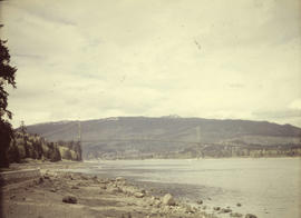
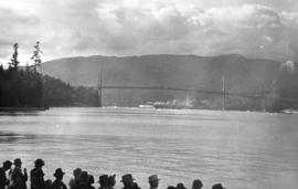
Stanley Park, Lions Gate Bridge from seawall beach
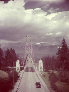
Stanley Park, Lions Gate Bridge southern approach
Item is a photograph of the southern approach to the Lion's Gate Bridge from Stanley Park. Looking north across the bridge, the road, decorative lions and pylons, and cables and piers are visible.
![[Opening of the] Granville Street Bridge](/uploads/r/null/c/0/5/c05d2065813671465eabef36d9411dcca4c82829a8da112fd67306402f09bf4f/08813588-144b-411e-849d-e00c23b44706-CVA229-07_142.jpg)
[Opening of the] Granville Street Bridge
![[View of fire at C.P.R. Pier D]](/uploads/r/null/2/c/2c02090b023c91ed1aa68611f638c9a7c926c231e753e952b004882e70e101d6/b94d05ba-0194-4a19-836b-dcc0391f0c10-A71079_142.jpg)
[View of fire at C.P.R. Pier D]
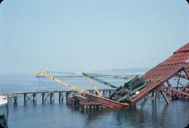
Item is a photograph showing the collapse of the bridge.

Second Narrows Bridge collapse
![[Aerial view of Vancouver]](/uploads/r/null/9/b/9b3acec26123edc53f11bf2f41f3286d09254ffea9918cd31b6715395ebe18d0/26473909-fe49-4474-8c3f-05eb1e8ab059-CVA1376-252_142.jpg)
Oblique view showing Fairview, Vancouver General Hospital, False Creek and the Expo 86 and other sites under development on the north side, Granville Island, Granville Bridge, Burrard Bridge, Yaletown, Downtown, the West End, Stanley Park and the Lions Gate Bridge, North Vancouver and The Lions in the background

View of nearly completed Burrard Street Bridge, St. Pauls Hospital, Vanier Park, and Kitsilano area
![[Fairview looking west across False Creek]](/uploads/r/null/6/c/6c05b70c30f9e5ad9e7cae8661ea506be1aee4ac7db1e8e882a88dd6a1f547df/a5476728-69a5-4ad1-9901-9a8006b8e414-CVA1376-204_142.jpg)
[Fairview looking west across False Creek]
Photograph shows a view from Hemlock Street and Broadway including the False Creek Indian Reserve, Granville and C.P.R. Kitsilano bridges, the McCreery and Johnston residences, a cannery and Taits Mill
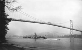
Royal convoy, H.M.C.S. "Crusader"
Item shows the vessel passing under the Lions Gate Bridge.
[Side view of centre portion of Burrard Bridge]

Aerial photo, oblique, CPR docks in foreground, looking south Granville Street at centre
Item is a photograph of the Vancouver waterfront, looking southwest down Burrard Street, showing the waterfront and downtown Vancouver, including Waterfront Station, Hotel Vancouver, Marine Building, Burrard Bridge, Granville Street Bridge, and the city beyond.

Aerial photo, vertical, Marpole and junction of Fraser River, Bridgeport
Item is a photograph of Marpole and northern Richmond, looking north. The area photographed centres on the fork of the Fraser River at Sea Island, and runs from W 67th Avenue to Cambie Rd., and from the western most tip of Richmond Island to the west tip of Mitchell Island. Includes the Marpole Bridge and both Oak Street and Moray bridges under construction.
![[Aerial view looking north over] Granville Island](/uploads/r/null/8/3/83f9be0a597100103c181fa4d68c68baa4a0802471126afafea3b7850103e12b/ea9e7fb6-7465-4fa6-8fa9-18923e3d9307-A49646_142.jpg)
[Aerial view looking north over] Granville Island
Oblique view showing the Granville Bridge and the new Granville Bridge under construction, the Kitsilano Trestle Bridge, of the Burrard Bridge and the industrial and undeveloped areas on the north and south sides of False Creek

Aerial photo, vertical, False Creek, Fairview to Kits Point
Item is a photograph of False Creek, showing English Bay to W 16th Avenue, and from Maple Street to the Cambie Street Bridge. Includes the Burrard Street Bridge, the new Granville Bridge, the Cambie Bridge, and Granville Island.