![[View of the old Hotel Vancouver from Georgia Street looking south east]](/uploads/r/null/a/b/ab8e3094528ff201ab9ab5dd1bbc4e4a9d9add39384a0b1502bc3249f988eab3/b218ff42-90cc-400a-b289-0c5fee623de8-A37881_142.jpg)
[View of the old Hotel Vancouver from Georgia Street looking south east]
- AM1376-: CVA 1376-154
- Item
- [1939]
Photograph shows the old Hotel Vancouver on the south side of Georgia Street at Howe during the Royal Visit.
64 results with digital objects Show results with digital objects
[View of the old Hotel Vancouver from Georgia Street looking south east]
Photograph shows the old Hotel Vancouver on the south side of Georgia Street at Howe during the Royal Visit.
![[View of Granville Street looking north from Smithe Street]](/uploads/r/null/2/9/296ac52a45a062e074035c36a5fe7d43bf512e2938e729f3fc2e364e178d4a3a/7cdfa249-5c36-431c-aac9-404adc9e0602-A37856_142.jpg)
[View of Granville Street looking north from Smithe Street]
Photograph shows retail businesses in the 800 block Granville Street between Smithe and Robson (Canada Shoe Repairing, Maple Leaf Theatre, Palms Hotel, Stewart & Co. Tailors and Bogardus-Wickins Ltd.), streetcar 284 "Fraser Ave", and the Vancouver Block clock.
![[View of Georgia Street looking east from the intersection of Burrard and Georgia Street]](/uploads/r/null/8/c/8cb732d381f3aeea1cdfd99a7d310341406c711f95934aeb3ab3fc1b1290c1ce/0d02026e-0a2c-4ae8-88a0-2d7c546053df-A37880_142.jpg)
[View of Georgia Street looking east from the intersection of Burrard and Georgia Street]
Photograph shows a view of Georgia Street with the old and new Hotel Vancouver on the south side and Christ Church Cathedral and the Medical Dental Building on the north side during the Royal Visit.
![[View of David Spencer department store on Hastings Street]](/uploads/r/null/5/5/55cd535fa74a8ab878c4e8c50592db38dbecccb2491b121f75ae8bf4c3e90f6e/5ec13dc5-b174-47f7-8e0f-f22d10506d31-A37883_142.jpg)
[View of David Spencer department store on Hastings Street]
Photograph shows Hastings Street and David Spencer department store decorated for the Royal Visit.
![[View of Cordova Street looking west from Carrall Street]](/uploads/r/null/e/2/e25516aa155966cfe727bde70112b511bb189e084f41254e00d20df544252fa9/82e3ef30-fb06-460d-98dd-dd2bd644dade-A71300_142.jpg)
[View of Cordova Street looking west from Carrall Street]
Photograph shows the Dunn-Miller block and number 12 and 16 street cars
![[View of Burrard Street looking south from West Pender Street]](/uploads/r/null/7/d/7d686a0815d064dd1e34c785dfbb3fd0195dca0994a8ef27bdc5c69044fc135d/d7021403-b9f2-4568-9310-0f3b8d21d462-A37882_142.jpg)
[View of Burrard Street looking south from West Pender Street]
Photograph shows Burrard Street and the face of the new Hotel Vancouver during the Royal Visit.
![[View looking west on Hastings Street from Main Street]](/uploads/r/null/6/7/67ceb69b300d314feb1922aee3c122915ca0bae57517ea1835eeb14b9889a10e/86355940-9d03-4cbb-85d7-5607e91e379e-2011-068_142.jpg)
[View looking west on Hastings Street from Main Street]
Photograph shows part of the Vancouver Museum (Carnegie Centre), the Ford Building and the Balmoral Hotell
![[View looking north from Granville Street and 14th Avenue]](/uploads/r/null/d/6/d69db2c2bb4b88fa530d16ebe363cdc169c4295d1b2970a2b748f72ca47a2b61/4074e348-0383-47fb-962c-715c80f990e4-A63891_142.jpg)
[View looking north from Granville Street and 14th Avenue]
Panoramic view showing part of Kitsilano, Fir Street, Fairview and the Kitsilano Trestle Bridge, the West End and Downtown in the background
![[View looking north along Commercial Drive at 2nd Avenue from an apartment on the southwest corner]](/uploads/r/null/6/b/6b970775d461a8528f4f5bd794174b003c73b21e98b4d45b0804908288f04506/d59930ec-3be2-438d-aa0c-451d6aed8d43-A50028_142.jpg)
[View looking north along Commercial Drive at 2nd Avenue from an apartment on the southwest corner]
Photograph shows the east side of the 1700 Block of Commercial Drive including the Grandview Theatre and other buildings and a No. 4 streetcar
![[View looking north along Commercial Drive at 2nd Avenue from an apartment on the southwest corner]](/uploads/r/null/e/6/e6848494e0e2bf0ea4105fbcee9cdf12af2baa734b69728c891dedba56ab45c0/28e396f5-649a-49c2-a1c6-29a33eb1fad3-A50029_142.jpg)
[View looking north along Commercial Drive at 2nd Avenue from an apartment on the southwest corner]
Photograph shows the east side of the 1700 Block of Commercial Drive including the Grandview Theatre and other buildings
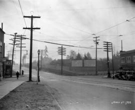
Vancouver, B.C. from the South
Photograph shows a view looking north from the corner of Westminster Avenue (Main Street) and 7th Avenue including the Westminster Avenue Trestle Bridge and False Creek in the background
![Vancouver [showing crowds on East Hastings Street]](/uploads/r/null/a/f/af1d229da2899fab87fd7200e66d70c47d010a06b3d025ad0880f613a0c4d957/8fa06694-3dba-40c0-ad87-b0167d638967-A72268_142.jpg)
Vancouver [showing crowds on East Hastings Street]

Vancouver residential street in snow
Item is a photograph showing a Vancouver residential street, possibly 5th Avenue, in snow.

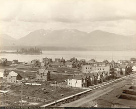
Panoramic view from Pender Street showing the C.P.R. car barge dock, the Immigration Building and Pier A and the squatter's shacks on Deadman's Island

Item is a photograph showing a tree lined residential street in autumn, probably in Shaughnessy Heights.

Procession July 1st, 1890 Cordova Street, Vancouver
Photograph shows a view looking west from Carrall Street including decoratations for Dominion Day and the Dunn-Miller Block
![Pender Street [at Hamilton Street with Odd Fellows Hall on left]](/uploads/r/null/5/2/a/52a20b6d9146aa06c3eac72931e4a1aac2db74932a6068b847fd074b5f57324b/901c2305-686b-4e21-931c-52936f8f4c3f-CVA220-08_142.jpg)
Pender Street [at Hamilton Street with Odd Fellows Hall on left]
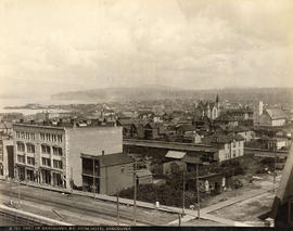
Part of Vancouver, B.C. from Hotel Vancouver
Photograph shows the east side of the 600 Block of Granville Street including the New York Block and a liquor store and beyond to the Homer Street Methodist Church, the tower of Holy Rosary Cathedral and houses
![[Palace Livery Stables, Burrard Street]](/uploads/r/null/d/4/d4c6988c2fd428dffe548a8494fc953d02df66fe2b74f5ccbee1e37a12520a5a/83952f62-7137-47be-ba15-7ae7143eea1b-A37896_142.jpg)
[Palace Livery Stables, Burrard Street]
Photograph shows the stables, snow-covered street and north shore mountains in the background..
Looking west up Hastings showing Flack Block and Dominion Building
![Looking east on Hastings [Street] from Howe [Street]](/uploads/r/null/e/a/ea05aa39c0a46ee21345d98715647bb2bf402993c2372614cb432f6f412c69fa/94567666-7917-46cd-ab03-909b4d48e8ca-A49843_142.jpg)
Looking east on Hastings [Street] from Howe [Street]
Photograph shows part of the Post Office (Federal) Building and part of the Royal Bank Building

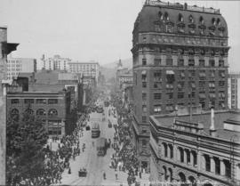
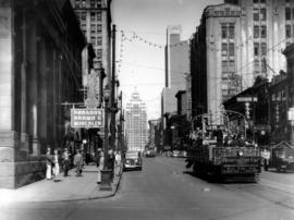
Looking east on Hastings Street from Homer Street showing sidewalks filled with people
Photograph shows businesses on the north side of the 300 Block of Hastings Street and the Dominion Trust Building
![[Looking east along the 600 block of] Hastings Street](/uploads/r/null/e/2/e2a3cdf3015ee6e23d01ef3caa461446879ff4a5a101e0005a6b4d73f2b7fd8c/ac9b4faa-4954-4eeb-bf85-504578ea1dae-A37895_142.jpg)
[Looking east along the 600 block of] Hastings Street
Photograph shows S. Blackson, tobacconist at the corner of Granville and Hastings Streets and other buildings on Hastings Street.

Looking down Burrard Street to the Marine Building
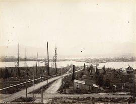
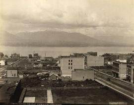
Looking Across the Inlet from Hotel Vancouver
Photograph shows a view looking north from Georgia Street showing the west side of the 600 Block Howe Street including Manor House and beyond to Deadman's Island
Looking Across the Inlet from Hotel Vancouver
Photograph shows a view looking north across Burrard Inlet from Granville Street and Georgia Street including the Van Horne Block and the Hudson Bay Company Store

Kingsway between Tyne and Battison Streets, looking west, construction
Item is a photograph of road construction on Kingsway, between Tyne Street and Battison Street, looking west. The photograph shows a man holding a flag and two B.C. Telephone Company workers work at the base of a utility pole. The building in the centre left of the photograph has "The Bungalow" written on the side.
Kingsway between Tyne and Battison Streets, looking west
Item is a photograph of road construction on Kingsway, between Tyne Street and Battison Street, looking west. The photograph shows a man holding a flag, mostly obscured by a warning sign, and B.C. Telephone Company workers work at the base of a utility pole. The building in the centre of the photograph has "The Bungalow" written on the side.
Kingsway between Tyne and Battison Streets, looking east
Item is a photograph of Kingsway, between Tyne Street and Battison Street, looking east. B.C. Telephone Co. equipment is visible at the construction site in the middle of the photograph. Advertisement billboards for The Seaton apartments and the Alcazar Hotel (Hotel Alcazar on the billboard) are visible. The building in the centre right of the photograph has "The Bungalow" written on the side.

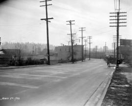
Kingsway between Knight and Dumfries, looking northwest
Item is a photograph of Kingsway, between Knight Street and Dumfries Street, looking northwest. The awnings and partial storefronts of Stella Mae's Dressmaking and Ed's Fish & Chips are visible along the sidewalk leading up to Knight Street on the right. Diagonally across the Kingsway and Knight Street intersection several local businesses can be seen, including the Wayside Barber Shop, Sun Chong & Co., and Flemons.

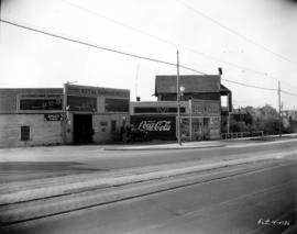
Kingsway at Victoria Drive, southwest, pre improvements
Item is a photograph of the intersection of Kingsway and Victoria Drive, looking southwest, before the Kingsway improvements. W. H. A. Van Alstine Drugs can be seen across Kingsway on the southeast corner of the intersection, on the southeast corner of the intersection Star Grocery, White Produce, and W. S. Parcells real estate can be seen. Advertisements for Coca-Cola, Toronto Dominion Trusts, and Seal Brand coffee are visible on the grocery store building.

Kingsway at Victoria Drive, southwest, post improvements
Item is a photograph of the intersection of Kingsway and Victoria Drive, looking southwest, after the Kingsway improvements. The corner of the empty W. H. A. Van Alstine Drugs location can be seen across Kingsway on the southeast corner of the intersection, on the southeast corner of the intersection an unidentified grocery store and W. S. Parcells real estate can be seen. Advertisements for Coca-Cola and Turret Cigarettes are visible on the grocery store building.

Kingsway at Victoria Drive, southeast, pre improvements
Item is a photograph of the intersection of Kingsway and Victoria Drive, looking southeast, before the Kingsway improvements. Identified establishments on the southeast corner include W. H. A. Van Alstine Drugs, George Collett Boot and Shoe Hospital (before its move to the 1900 block of Kingsway), Maple Leaf Barber Shop, and Bell's Grocery. Across Kingsway in the right of the photograph is Star Grocery. There is a billboard for Turret Cigarettes across the intersection on Victoria.
Kingsway at Victoria Drive, southeast, post improvements
Item is a photograph of the intersection of Kingsway and Victoria Drive, looking southeast, after the Kingsway improvements. Identified establishments on the southeast corner include the empty W. H. A. Van Alstine Drugs location (the old sign is visible behind the building) and Maple Leaf Barber Shop. There is a billboard for Shell Gasoline across the intersection further along Victoria. New utility poles, street light, and sidewalks care visible in the photograph, and the buildings have been renovated to accommodate the widened street.

Kingsway at Perry Street, Jones Tent and Awning Co. Ltd., pre improvements
Item is a photograph of Kingsway at Perry Street, looking northwest at the Jones & Son Tent and Awning Co. Ltd. Building. This photograph was taken before the building was shortened to make room for street widening and other improvements.
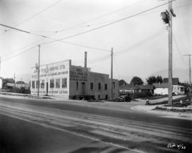
Kingsway at Perry Street, Jones Tent and Awning Co. Ltd., post improvements
Item is a photograph of Kingsway at Perry Street, looking northwest at the Jones & Son Tent and Awning Co. Ltd. Building. This photograph was taken after the Kingsway expansion and other new street improvements had taken place. The building has been shortened on front, with a new facade, and expanded on the back.
Kingsway at Knight, looking southeast at intersection
Item is a photograph of the intersection of Kingsway and Knight Street, looking southeast, during the Kingsway improvements. On the left edge the signage for Ideal Fish & Chips can be seen, and on the corner across Knight is Ed's Fish & Chips. The newly constructed fence and billboards are visible at the southeast corner of the intersection in the upper right corner, but the road widening and other improvements have not been completed.

Kingsway at Knight, Ed's Fish & Chips
Item is a photograph of the intersection of Kingsway and Knight Street, looking southeast. The building on the corner is Ed's Fish & Chips.

Kingsway at Knight Street, southwest corner, pre improvements
Item is a photograph of Kingsway at Knight Street, southwest corner, looking east, before the Kingsway improvements. The photograph shows the sidewalk in front of Herbert Eldridge Drugs and the fence and sidewalk sections across Knight Street that would be soon renovated.

Kingsway at Knight Street, southwest corner, post improvements
Item is a photograph of Kingsway at Knight Street, southwest corner, looking east, after the Kingsway improvements. The photograph shows the new sidewalk in front of Herbert Eldridge Drugs, the widened section of Kingsway, and the fully renovated fence and sidewalk sections across Knight Street. New billboards on Knight Street have advertisements for Forst's Radio (selling Philco radios) and City Coal Co.

Kingsway at Knight Street, southeast corner, pre improvements
Item is a photograph of the intersection of Kingsway and Knight Street, looking at the southeast corner, before the Kingsway improvements. The photograph shows the street, fence and sidewalk sections at the intersection that would be soon renovated.

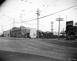
Kingsway at Commercial, pre improvements
Item is a photograph of intersection of Kingsway and Commercial, looking south-east, before the Kingsway improvements. The identified establishments in the photograph are Kingsway Drug Co. Ltd, Fletcher's Meats Co. (Fletcher's No 1 Bacon on sign), and Scott's Home Bakery.

Kingsway at Commercial, post improvements
Item is a photograph of intersection of Kingsway and Commercial, looking south-east, after the Kingsway improvements. The identified establishments in the photograph are Kingsway Drug Co. Ltd, Fletcher's Meats Co. (Fletcher's No 1 Bacon on sign), and Scott's Home Bakery.

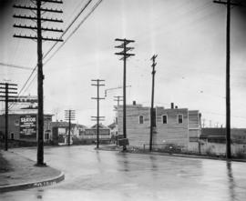
Kingsway at Commercial Drive, Natal Garage, pre improvement
Item is a photograph of Kingsway at Commercial Drive looking west at the southwest corner of the intersection, before the Kingsway improvements. The photograph shows a small corner store, the Natal Garage and service station, and a building under construction. Coca-Cola and Orange Crush signs are on the side of the corner store, and a delivery truck for Fletcher's No. 1 Bacon is at the service station.
Kingsway at Commercial Drive, Natal Garage, post improvement
Item is a photograph of Kingsway at Commercial Drive looking west at the southwest corner of the intersection, after the Kingsway improvements. The photograph shows the Natal Garage and service station and a convince store. Coca-Cola and Orange Crush signs are on the side of the convenience store. The new sidewalks, utility poles with street lamps, and the newly expanded road are all visible.

Kingsway at Beatrice, pre improvements
Item is a photograph of Kingsway at Beatrice, looking southeast, before the Kingsway improvements. Identified establishments visible in the photograph include Kingsway Woodworks, Steele and Co., and the Tyrell Block.

Kingsway at Beatrice, post improvements
Item is a photograph of Kingsway at Beatrice, looking southeast, after the Kingsway improvements. Identified establishments visible in the photograph include Kingsway Woodworks, Geo. Collett Boot & Shoe Hospital, Steele and Co., and the Tyrell Block.

Photograph shows signs for the Hotel Barmoral and the Pantages Theatre
Hastings Street west of Homer Street
Photograph shows an Observation Car, Spencer's Department Store and the Marine Building in the background

Hastings Street west of Homer Street
Photograph shows banners across Hastings Street reading: "Many men making money means much for Vancouver," "Hurrah!! Tell our Tale. Talk our Town," and "Vancouver 100 000 in 1910." and a horse-drawn wagon and a street car in the background