Showing 3 results

Archival description
City of Vancouver Archives technical and cartographic drawing collection
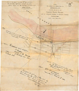
 Canadian Pacific Railway Company
Print preview View:

3 results with digital objects Show results with digital objects

Map of Manitoba, Kewaydin, British Columbia and North West Territory shewing the country traversed by the Canadian Pacific Railway

Item is a map showing the extent of the Canadian Pacific Railway Company (C.P.R.) in Canada in 1883. Map shows boundaries, roads, trails, telegraph lines, towns, rivers, lakes and mountainous terrain in British Columbia, the North West Territory (Alberta, Athabasca, Saskatchewan, Assiniboia), Manitoba and Kewaydin, as well as some of Ontario and Western Quebec. Map is folded inside a book titled "North West Territory, Canada."

Plan of a portion of the water front of Vancouver city

Item is a tracing of a map showing the Vancouver waterfront between Granville and Carrall streets. The original map contains a number of attestations which have been traced: by W.C. Van Horne (Mar. 11, 1886); H.J. Cambie, Engineer in charge (Feb. 22, 1886); T. Trudeau, Deputy Minister of Railways (31 Mar. 1886); and Land Registry office (12 May 1886). The Tracing was made from a copy submitted as an appendix to an affadvit May 28, 1891.