
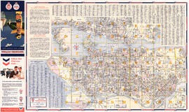
Street map of Greater Vancouver : map cover, street index and advertisements
- AM1594-: MAP 977-: LEG1335.2
- Part
- 1959
Part of City of Vancouver Archives technical and cartographic drawing collection
246 results with digital objects Show results with digital objects
Street map of Greater Vancouver : map cover, street index and advertisements
Part of City of Vancouver Archives technical and cartographic drawing collection

Street map of Greater Vancouver showing distances from Bekins building
Part of City of Vancouver Archives technical and cartographic drawing collection

Victoria, vicinity and Vancouver Island
Part of City of Vancouver Archives technical and cartographic drawing collection
Part is a sheet with three maps: a street map of Victoria, a map of major roads and highways in Greater Victoria, and a highway map of Vancouver Island. The sheet includes street indexes and a mileage chart.
Part of City of Vancouver Archives technical and cartographic drawing collection
Part is a street map of Greater Vancouver (including West Vancouver, North Vancouver, Vancouver, Burnaby New Westminster and parts of Richmond, Coquitlam and Surrey). The sheet also includes a street index and tourist information for U.S. border crossing

Part of City of Vancouver Archives technical and cartographic drawing collection
Part contains maps of the Richmond and downtown Vancouver transit systems, a street index to the Greater Vancouver map on the other side of the sheet, information on B.C. Electric transit routes, and general tourist information.

Transit system map of Greater Vancouver, B.C.
Part of City of Vancouver Archives technical and cartographic drawing collection
Part contains a map of Greater Vancouver showing bus lines, route numbers, B.C. Electric installations, block numbers, points of interest and amenities; an inset map showing streets in Gleneagles, Whytecliff, and Horseshoe Bay; and an inset map showing streets in Port Moody, Coquitlam, and Maillardville.

Part of City of Vancouver Archives technical and cartographic drawing collection


Street map of Greater Victoria, B.C., map cover, and street index of Greater Vancouver
Part of City of Vancouver Archives technical and cartographic drawing collection
Part contains a map of Greater Victoria showing highways, streets, parks, golf courses and country clubs, institutions, block numbers, city and municipal boundaries and Shell marine stations, and a street index for the Greater Vancouver map on the other side of the sheet.

Street map of Greater Vancouver, B.C.
Part of City of Vancouver Archives technical and cartographic drawing collection
Part contains a map of Greater Vancouver showing highways, streets, parks, golf courses and country clubs, institutions, block numbers, city and municipal boundaries and Shell marine stations.

Circulation map of Greater Vancouver : today's market data on Vancouver
Part of City of Vancouver Archives technical and cartographic drawing collection
Part contains maps and population and circulation data for three areas: Retail City Area, Retail Suburban Area, and All Other Country Area.

Map of Vancouver Sun's city circulation
Part of City of Vancouver Archives technical and cartographic drawing collection

A sketch design for a nonconformist church
Part of City of Vancouver Archives technical and cartographic drawing collection
Part contains front and side elevations for a church building.
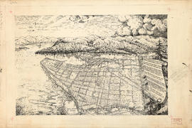
Pictorial map of Greater Vancouver
Part of City of Vancouver Archives technical and cartographic drawing collection
Part contains an illustrated map (not drawn to scale) of Vancouver and the surrounding area and a celebratory poem. An annotation at the edge of the drawing proposes inverting two lines of the poem.

Part of City of Vancouver Archives technical and cartographic drawing collection
Part is an overlay designed to be used with a pictorial map of Greater Vancouver to show key dates in various areas.

Greater Vancouver's land resources
Part of City of Vancouver Archives technical and cartographic drawing collection
Part is a page of text of land use, regional land use policy, planning for future growth

Part of City of Vancouver Archives technical and cartographic drawing collection
Part is a map showing types of land use in Greater Vancouver, with a chart showing area of specified uses: open and undeveloped, residential, industrial, agricultural, commercial, institutional, transportation, communication and utilities, recreation, and
Part of City of Vancouver Archives technical and cartographic drawing collection
Part is the verso side of a sheet, containing a map depicting major buildings in downtown Vancouver, colour coded by type, as well as a street index and a short history of Vancouver.
Cityscape: A map of downtown Vancouver
Part of City of Vancouver Archives technical and cartographic drawing collection
Part is the recto side of a sheet, containing two maps, as well as lists of restaurants, entertainment venues, hotels, department stores, malls, art galleries, cab companies, and a brief history of Stanley Park. Maps are a street map of downtown and Stanl
Part of City of Vancouver Archives technical and cartographic drawing collection
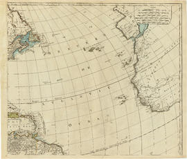
Part is the top right portion of a map of the Americas, and depicts the north-eastern portion of the Canadian coast, the eastern portion of the West Indies, the north-east corner of South America and the coastal areas of south-west Europe and wesern Africa.
Part of City of Vancouver Archives technical and cartographic drawing collection
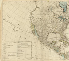
Part is the top left hand quadrant of a map of the Americas, and depicts North America and the north-west portion of South America. The sheet also includes a list of territories and islands in North America and appears to relate to territorial divisions as a result of the Treaty of Paris and the Treaty of Versailles (1783).

Part of City of Vancouver Archives technical and cartographic drawing collection
Part depicts the right-hand side of a map of the lunar surface viewable from Earth, a chart of the Analemma, a chart and accompanying text entitled "the vicissitude of seasons explained", a chart and accompanying text on "the art of dialing by a common globe", and a map of the southern portion of Africa and Asia, as well as Australia.
Dunn, Samuel

Part of City of Vancouver Archives technical and cartographic drawing collection
Part depicts text and accompanying diagram on "the art of dialing by a common globe", a chart of universal scale, a map of the world using Mercator's projection, a map of the southern half of the Americans, descriptions of the various maps and charts, and the left-hand side of a map of the lunar surface viewable from Earth.
Dunn, Samuel
Part of City of Vancouver Archives technical and cartographic drawing collection
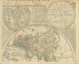
Part depicts a chart of the astronomical latitude & longitude analemma, a table showing values of the place of the sun in the ecliptic & declinatiobn, a chart of the constellations viewable in the southern hemisphere, text on geographical definitions and the cause of the tides, and a map of the northern portion of Africa, Europe and Asia.
Dunn, Samuel

Part of City of Vancouver Archives technical and cartographic drawing collection
Part depicts the upper left hand quadrant of the map, and includes a diagram of the solar system, a table of dimensions of bodies in the solar system, a chart of constellations viewable in the northern hemisphere, text on geographical definiations and the cause of the tides, and a map of the northern half of the Americas.
Dunn, Samuel
Part of City of Vancouver Archives technical and cartographic drawing collection
Item is a sheet containing "Description of the Panama Canal and Progress of the Works" illustrated by eighteen photographs, and a chart of distances in nautical miles between 62 world ports.
World maps and heads of government
Part of City of Vancouver Archives technical and cartographic drawing collection
Item is a sheet with a map of the world and a political and physical map of the Panama Canal Zone; these are surrounded by photographic portraits of twenty-fours heads of state, Roald Amundsen and Robert E. Peary.
Part of City of Vancouver Archives technical and cartographic drawing collection
Item is a sheet with a photograph of the federal Parliament buildings in Ottawa, and biographical sketches of Governors General and Prime Ministers of Canada, as well as of present provincial Lieutenants Governor; a list of Governors General and Prime Min
Part of City of Vancouver Archives technical and cartographic drawing collection
Item is a sheet with maps of Canada, Newfoundland, and the United States; photographs of the Lieutenant Governors of each province, the Governor General and various Prime Ministers of Canada.
Part of City of Vancouver Archives technical and cartographic drawing collection
Item is a sheet of general and statistical information about British Columbia: lists of principal freshwater and saltwater lakes of the world, and index of British Columbia towns and British Columbia political, demographic and economic information.
Part of City of Vancouver Archives technical and cartographic drawing collection
Item is a sheet which includes maps of British Columbia, England, Scotland, Ireland and the world polar region; photographs of Hon. R.L. Borden (Prime Minister of Canada) and S. Richard McBride (Premier of British Columbia), as well as illustrations of Ha

Part of City of Vancouver Archives technical and cartographic drawing collection

Part of City of Vancouver Archives technical and cartographic drawing collection

Part of City of Vancouver Archives technical and cartographic drawing collection
Part is a map of a portion of the Rocky Mountains including Rocky Mountains Park, Yoho Park, Kootenay Park, Glacier Park, and Revelstoke Park. Map shows rail lines, steamship routes, roads, trails, waterfalls, glaciers, rivers, elevations, and locations of amenities.

Part of City of Vancouver Archives technical and cartographic drawing collection
Part contains an illustrated map of West Vancouver and North Vancouver showing major streets, mountains, rivers and creeks, and recreational attractions; a street index to the Greater Vancouver map on the other side of the sheet; a list of golf courses; and real estate information including a description of professional realtors, an amortization table, and calculations showing amounts paid in rent over many years.

Street map of Greater Vancouver, B.C.
Part of City of Vancouver Archives technical and cartographic drawing collection
Part contains a street map of Greater Vancouver showing block numbers, neighbourhood boundaries, schools, churches by denomination, and main shopping centres. An inset map shows the Forest Hills - Canyon Heights area.
![City of Vancouver surrounding [sic] and municipalities including City of New Westminster](/uploads/r/null/8/9/1/8919931915a624a5abd2e5d2953118fdd853654343ce31193f00d341d482bf39/fd6eb299-3e6a-498e-bfd9-62a3279a8861-LEG1329_142.jpg)
City of Vancouver surrounding [sic] and municipalities including City of New Westminster
Part of City of Vancouver Archives technical and cartographic drawing collection
Part contains a street map showing distances from a point in downtown Vancouver, waterfront businesses in Burrard Inlet, street car lines, bus lines, parks, golf courses, schools and hospitals.

Free map of Vancouver, New Westminster and surroundings
Part of City of Vancouver Archives technical and cartographic drawing collection
Part contains information about Vancouver parks, promotional text for British Columbia Electric Railway, and advertisements for other businesses.

Street Map of Greater Vancouver, B.C.
Part of City of Vancouver Archives technical and cartographic drawing collection
Part consists of the back side of a road map. The main map is a road map of Greater Vancouver; the sheet also includes inset road maps of Coquitlam, West Vancouver, and Highway 99 to Squamish.

Fraser Valley, Surrey & Richmond
Part of City of Vancouver Archives technical and cartographic drawing collection
Part consists of the front side of a published road map. This side contains road maps of the Fraser Valley, Richmond, and Surrey, as well as street indexes.

Indexed map of Greater Vancouver : map cover and advertisements
Part of City of Vancouver Archives technical and cartographic drawing collection
Part contains information on the services and facilities of Bekins Moving and Storage Co.

Indexed map of Greater Vancouver showing distances from Bekins building
Part of City of Vancouver Archives technical and cartographic drawing collection

Part of City of Vancouver Archives technical and cartographic drawing collection
Part contains street maps of the University Endowment Lands, Surrey, Maillardville, Lulu Island and Sea Island, tourist information about Vancouver, and text advertising the products and services of the Dominion Map and Blueprint Company.

Dial map of Greater Vancouver and suburbs
Part of City of Vancouver Archives technical and cartographic drawing collection
Part contains a street map of Vancouver, Burnaby, New Westminster, West Vancouver and North Vancouver showing block numbers, street car, bus, and railway lines, parks and hospitals. Map includes two dials (a numbered circle, a paper indicator, a grid of block numbers and a street index used to find locations). A small inset map shows the Capitol Hill/Scenic Park area of Burnaby in greater detail.

Part of City of Vancouver Archives technical and cartographic drawing collection
Part consists of a map showing major roadways in the Lower Mainland and the Fraser Valley from Vancouver to Chilliwack, and lists of Vancouver businesses, schools, public buildings, hospitals, bathing beaches, fire halls, and golf and country clubs. Part includes text advertising the products and services of the Dominion Map and Blueprint Company.

Dial map of Greater Vancouver and suburbs
Part of City of Vancouver Archives technical and cartographic drawing collection
Part contains a street map of Vancouver, Burnaby, New Westminster, West Vancouver, and North Vancouver showing railways, hospitals, parks and block numbers. The map includes two dials (numbered circles, paper indicators, a grid of block numbers and a street index used to find locations).

Map of Burnaby and New Westminster, British Columbia
Part of City of Vancouver Archives technical and cartographic drawing collection
Part consists of a street map of Burnaby and New Westminster, information on bus and street car routes, and text advertising the products and services of the Dominion Map and Blueprint Company.

Part of City of Vancouver Archives technical and cartographic drawing collection
Part contains a street map of Vancouver showing streets, block numbers, bus routes, railway lines, boundaries, private roads and hospitals. The map includes a dial (a numbered circle, a paper indicator, a grid of block numbers and a street index used to find locations in Vancouver). A small inset shows the streets surrounding Queen Elizabeth Park, which are obscured on the main map where the indicator is attached.

Part of City of Vancouver Archives technical and cartographic drawing collection
Part contains a street map of Greater Vancouver.

Part of City of Vancouver Archives technical and cartographic drawing collection
Part contains a map showing major roads from the North Shore to Bellingham, Washington; a map showing major roads in the Victoria area from Cobble Hill in the northwest to Sooke in the southwest; and traffic rules for Vancouver.