
Greater Vancouver's land resources
- AM1594-: MAP 927-: LEG1965.02
- Part
- Mar. 1983
Part of City of Vancouver Archives technical and cartographic drawing collection
Part is a page of text of land use, regional land use policy, planning for future growth
246 results with digital objects Show results with digital objects
Greater Vancouver's land resources
Part of City of Vancouver Archives technical and cartographic drawing collection
Part is a page of text of land use, regional land use policy, planning for future growth

Part of City of Vancouver Archives technical and cartographic drawing collection
Part is a map showing types of land use in Greater Vancouver, with a chart showing area of specified uses: open and undeveloped, residential, industrial, agricultural, commercial, institutional, transportation, communication and utilities, recreation, and
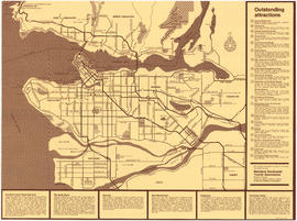
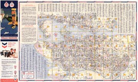
Cityscape: A map of downtown Vancouver
Part of City of Vancouver Archives technical and cartographic drawing collection
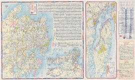
Part is the recto side of a sheet, containing two maps, as well as lists of restaurants, entertainment venues, hotels, department stores, malls, art galleries, cab companies, and a brief history of Stanley Park. Maps are a street map of downtown and Stanl
Part of City of Vancouver Archives technical and cartographic drawing collection
Part is the verso side of a sheet, containing a map depicting major buildings in downtown Vancouver, colour coded by type, as well as a street index and a short history of Vancouver.
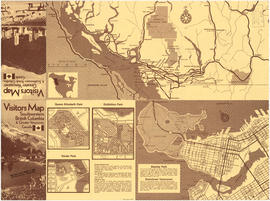
Neighbourhood maps and British Columbia map
Part of City of Vancouver Archives technical and cartographic drawing collection
Part is a sheet containing maps of: southwest British Columbia, including highways; a key map showing British Colombia within North America; downtown Vancouver map; the Exhibition Park site; Queen Elizabeth Park; and Vanier Park. The sheet also includes i
Part of City of Vancouver Archives technical and cartographic drawing collection
Part is a sheet with a highway map of Greater Vancouver, with a list of attractions keyed to numbers on the map, as well as information on Greater Vancouver municipalities: North Shore; Sunshine Coast/Squamish area; Burnaby; New Westminster; Richmond; and
Part of City of Vancouver Archives technical and cartographic drawing collection
Part is a page with information on the British Columbia Automobile Association. The sheet includes maps of Richmond; Vancouver and the Fraser Valley; and Coquitlam and Port Moody. The sheet also includes traffic interchange diagrams and a street index for
Street Map of Greater Vancouver
Part of City of Vancouver Archives technical and cartographic drawing collection
Part is a page with three maps. The main map shows Greater Vancouver including the municipalities of West and North Vancouver, Burnaby, New Westminster and a portion of Coquitlam. The two inset maps show Horseshoe Bay and Highway 99 to Squamish.

Champlain Heights : D.L. 334, group one, N.W.D.
Part of City of Vancouver Archives technical and cartographic drawing collection
Part is a map showing lot numbers, lot sizes, lot values and sidewalk crossings in the area from Rosemont Drive in the north to 63rd Avenue in the south and from Butler Street in the east to Kerr Street in the west.

City of Vancouver : residential lots, Area B, Champlain Heights : page 2
Part of City of Vancouver Archives technical and cartographic drawing collection
Part is the second of two sheets outlining details associated with the sale of lots in Champlain Heights as shown on the map "Champlain Heights : D.L. 334, group one, N.W.D." (LEG1315.1).

City of Vancouver : residential lots, Area B, Champlain Heights : page 1
Part of City of Vancouver Archives technical and cartographic drawing collection
Part is the first of two sheets outlining details associated with the sale of lots in Champlain Heights as shown on the map "Champlain Heights : D.L. 334, group one, N.W.D." (LEG1315.1).

Fraser Valley, Surrey & Richmond
Part of City of Vancouver Archives technical and cartographic drawing collection
Part consists of the front side of a published road map. This side contains road maps of the Fraser Valley, Richmond, and Surrey, as well as street indexes.

Street Map of Greater Vancouver, B.C.
Part of City of Vancouver Archives technical and cartographic drawing collection
Part consists of the back side of a road map. The main map is a road map of Greater Vancouver; the sheet also includes inset road maps of Coquitlam, West Vancouver, and Highway 99 to Squamish.

Part of City of Vancouver Archives technical and cartographic drawing collection
Part is the back side of a tourist brochure. The sheet contains four maps, for the Trans-Canada Highway, Stanley Park, Vancouver Island, and Greater Vancouver.

Greater Victoria provincial electoral districts
Part of City of Vancouver Archives technical and cartographic drawing collection
Part is a map showing provincial electoral ridings: Esquimalt, Victoria, Oak Bay, and Saanish & the Islands.
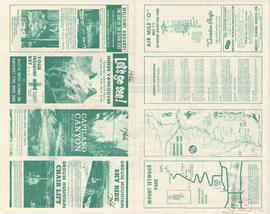
Let's go see! Inside Vancouver
Part of City of Vancouver Archives technical and cartographic drawing collection
Part is the front side of a tourist brochure. The page includes information of tourism sites on the North Shore, including Capilano Canyon, Grouse Mountain, Mount Seymour Park, and general information on the area.
Map of Greater Vancouver and Lower Mainland area
Part of City of Vancouver Archives technical and cartographic drawing collection
Part is the outer side of the cover in which the attached map was folded. The page includes promotional information on the Vancouver Real Estate Board and the Multiple Listing Service, a list of sites of interest in Vancouver, and an amortization table.
Map of Delta, Langley, Richmond and Surrey
Part of City of Vancouver Archives technical and cartographic drawing collection
Part is a street map of the Delta, Langley, Richmond and Surrey municipalities. The map includes a road and street index.
Agency Press Limited
Street Map of Greater Vancouver
Part of City of Vancouver Archives technical and cartographic drawing collection
Part is a street map of Greater Vancouver, from Coquitlam westward and north of the Fraser River. The sheet includes inset maps of Downtown Coquitlam, Gleneagles to Horseshoe Bay, and Highway 99 from West Vancouver to Squamish. The sheet also includes a s
Agency Press Limited
Greater Vancouver recreation sites and parks
Part of City of Vancouver Archives technical and cartographic drawing collection
Part is the inner side of the cover in which the attached map was folded. The page includes lists of various types of recreational sites and parks in Vancouver, Burnaby, New Westminster, North Vancouver and West Vancouver.

Lower Mainland provincial electoral districts
Part of City of Vancouver Archives technical and cartographic drawing collection
Part is a map showing provincial electoral ridings: West Vancouver-Howe Sound, North Vancouver-Capilano, North Vancouver-Seymour, Vancouver Centre, Vancouver East, Vancouver-Point Grey, Vancouver-Burrard, Vancouver-Little Mountain, Vancouver South, Richmo
Greater Vancouver recreation sites and parks
Part of City of Vancouver Archives technical and cartographic drawing collection
Part is the inner side of the cover in which the attached map was folded. The page includes lists of various types of recreational sites and parks in Vancouver, Burnaby, New Westminster, North Vancouver and West Vancouver.
Map of Greater Vancouver and Lower Mainland area
Part of City of Vancouver Archives technical and cartographic drawing collection
Part is the outer side of the cover in which the attached map was folded. The page includes promotional information on the Vancouver Real Estate Board and the Multiple Listing Service, a list of sites of interest in Vancouver, and an amortization table.
Street map of Greater Vancouver
Part of City of Vancouver Archives technical and cartographic drawing collection
Part is a street map of Greater Vancouver, from Coquitlam westward and north of the Fraser River. The sheet includes inset maps of Downtown Coquitlam, Gleneagles to Horseshoe Bay, and Highway 99 from West Vancouver to Squamish. The sheet also includes a s
Agency Press Limited

Dispersal routes for the Vancouver zone
Part of City of Vancouver Archives technical and cartographic drawing collection

Part of City of Vancouver Archives technical and cartographic drawing collection
Part contains a street map of downtown Vancouver, a street map of Vancouver and the Fraser Valley, detail maps showing traffic interchanges corresponding to numbers on the Fraser Valley map, and general tourist information.

Street map of Greater Vancouver, B.C.
Part of City of Vancouver Archives technical and cartographic drawing collection
Part contains a street map of Greater Vancouver showing block numbers, parks, golf courses, cemeteries, and hospitals; inset maps showing streets in Coquitlam and the Horseshoe Bay area; and a map showing Highway 99 from Horseshoe Bay to Squamish.
Map of Delta, Langley, Richmond and Surrey
Part of City of Vancouver Archives technical and cartographic drawing collection
Part is a street map of the Delta, Langley, Richmond and Surrey municipalities. The map includes a road and street index.
Agency Press Limited
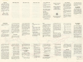
Target area civil defence survival instructions
Part of City of Vancouver Archives technical and cartographic drawing collection

Part of City of Vancouver Archives technical and cartographic drawing collection
Part is the cover and back page of a pamphlet. The back page is an index map of the province, showing the area covered by the main map on the interior (verso) sheet of the pamphlet.

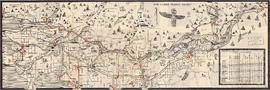
The service route to - from - through industrial southwestern British Columbia
Part of City of Vancouver Archives technical and cartographic drawing collection
Part is a map depicting Greater Vancouver east to Chilliwack, showing the locations of B.C. Hydro rail routes, routes of other rail companies, interchanges, industrial development sites, and municipal boundaries and 1961 census figures.

Part of City of Vancouver Archives technical and cartographic drawing collection
Part contains a street map of Greater Vancouver with street index, an inset map showing the streets of Horseshoe Bay, Whytecliff, and Caulfeild, and advertising Chevron gasolines and RPM motor oils.
Maps of Victoria and Vancouver Island, mileage chart and traffic routes
Part of City of Vancouver Archives technical and cartographic drawing collection
Part contains a street map of Victoria with street index, a map of Victoria and vicinity showing major roads, a map of Vancouver Island showing highways, a mileage chart, and traffic rules for Vancouver and Victoria.

Greater Vancouver sewerage and drainage district : general and statistical information
Part of City of Vancouver Archives technical and cartographic drawing collection

Principal freight railway facilities of British Columbia Hydro and Power Authority
Part of City of Vancouver Archives technical and cartographic drawing collection
Part contains a map showing the B.C. Electric railway (including the Vancouver and Lulu Island branch), other railways, interchange points and municipal city boundaries.

Map of railway freight lines operated by British Columbia Hydro and Power Authority : map cover
Part of City of Vancouver Archives technical and cartographic drawing collection

Part of City of Vancouver Archives technical and cartographic drawing collection
Part contains a map showing trunk sewers and drains constructed, facilities under design and/or construction, pumping stations and sewage treatment plants in the Greater Vancouver area.
Part of City of Vancouver Archives technical and cartographic drawing collection
Part is a map of the greater Vancouver area, showing communities across the region, with pictographs representing various communities. The map also includes a mileage table showing driving distances between various communities in Greater Vancouver.
British Columbia. Travel Bureau
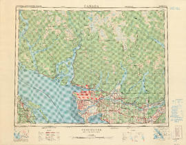
Part of City of Vancouver Archives technical and cartographic drawing collection
Part contains a map of the Greater Vancouver area showing topographic contour lines at 500-foot intervals, roads and road characteristics, railways, parks, towns, reserves, elevations, airports, streams, lakes, and adminstrative boundaries. Includes a key plan of adjoining sheets published in the same series and a small ancillary map showing the declination of the compass needle in 1958.

Victoria, vicinity and Vancouver Island
Part of City of Vancouver Archives technical and cartographic drawing collection
Part is a sheet with three maps: a street map of Victoria, a map of major roads and highways in Greater Victoria, and a highway map of Vancouver Island. The sheet includes street indexes and a mileage chart.

Map of Vancouver, Burnaby, New Westminster, British Columbia : street index and advertisements
Part of City of Vancouver Archives technical and cartographic drawing collection
Part contains a street index for the main map of Vancouver on the other side of the sheet, advertisements for Bekins Moving and Storage and Allied Van Lines, and three maps showing the companies' service areas in the United States, Canada, and British Columbia and Alberta. An annotation reads: "Oppenheimer collection."

Part of City of Vancouver Archives technical and cartographic drawing collection
Part contains maps of the Richmond and downtown Vancouver transit systems, a street index to the Greater Vancouver map on the other side of the sheet, information on B.C. Electric transit routes, and general tourist information.

Street map of Greater Vancouver showing distances from Bekins building
Part of City of Vancouver Archives technical and cartographic drawing collection

Part of City of Vancouver Archives technical and cartographic drawing collection
Part contains a map of Greater Vancouver showing the locations of Bekins Moving and Storage, distances from the Burrard Street and York Street location and city streets. Part includes four photographic images of points of interest in Vancouver.

Part of City of Vancouver Archives technical and cartographic drawing collection
Part contains key of signs and symbols in English and French.

Street map of Greater Vancouver : map cover, street index and advertisements
Part of City of Vancouver Archives technical and cartographic drawing collection
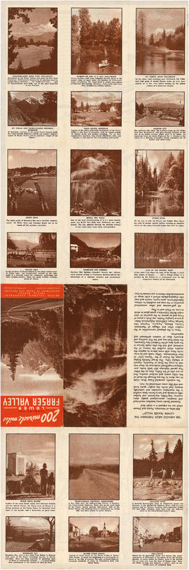
200 miracle miles through the Lower Fraser Valley
Part of City of Vancouver Archives technical and cartographic drawing collection
Part is one side of an unfolded tourism promotion brochure. The various panels depict photographs and give basic information on various sites mapped on the verso of the sheet.
British Columbia. Travel Bureau

Transit system map of Greater Vancouver, B.C.
Part of City of Vancouver Archives technical and cartographic drawing collection
Part contains a map of Greater Vancouver showing bus lines, route numbers, B.C. Electric installations, block numbers, points of interest and amenities; an inset map showing streets in Gleneagles, Whytecliff, and Horseshoe Bay; and an inset map showing streets in Port Moody, Coquitlam, and Maillardville.
Part of City of Vancouver Archives technical and cartographic drawing collection
Part is a street map of Greater Vancouver (including West Vancouver, North Vancouver, Vancouver, Burnaby New Westminster and parts of Richmond, Coquitlam and Surrey). The sheet also includes a street index and tourist information for U.S. border crossing

Transit system map of Greater Vancouver, B.C.
Part of City of Vancouver Archives technical and cartographic drawing collection
Part contains a map of Greater Vancouver showing bus lines, route numbers, B.C. Electric installations, block numbers, points of interest and amenities; an inset map showing streets in Gleneagles, Whytecliff, and Horseshoe Bay; and an inset map showing streets in Port Moody, Coquitlam, and Maillardville.