
Zoning Map: City of Vancouver, British Columbia
- PUB-: PD 2100.4
- Item
- May 1974
Part of City publications collection
Item is a zoning map showing different zoning districts of Vancouver in 1974. Map has a plastic overlay shows local areas.
Zoning Map: City of Vancouver, British Columbia
Part of City publications collection
Item is a zoning map showing different zoning districts of Vancouver in 1974. Map has a plastic overlay shows local areas.

Zoning Map: City of Vancouver, British Columbia
Part of City publications collection
Item is a zoning map showing different zoning districts of Vancouver in 1963.

Zoning Map: City of Vancouver, British Columbia
Part of City publications collection
Item is a zoning map showing different zoning districts of Vancouver in 1969.

Zoning Map: City of Vancouver, British Columbia
Part of City publications collection
Item is a zoning map showing different zoning districts of Vancouver in 1960.
![Zoning map : City of Vancouver, British Columbia [verso]](/uploads/r/null/0/c/0c28eac99426ce4ba64e4dfd48e45082c152014d6316047710a9601978663e70/d7052696-ccd5-4643-98d6-5e29205d9903-PD2100_142.jpg)
Zoning map : City of Vancouver, British Columbia [verso]
Part of City publications collection
Item component isthe verso of a Vancouver zoning map 1998 containing a brief description of the intent of the zoning districts schedules.
![Zoning map : City of Vancouver, British Columbia [verso]](/uploads/r/null/8/e/8e44e80ba947d96b0a59a2bf4a48b60a1421fd04ba8480ddd13d7d13d0702e36/6b887f4f-8b76-48e2-866b-15499f569972-PD2100_142.jpg)
Zoning map : City of Vancouver, British Columbia [verso]
Part of City publications collection
Item component is the verso of the map containing a brief description of the intent of the zoning districts schedules.
![Zoning map : City of Vancouver, British Columbia [front side]](/uploads/r/null/c/6/c61049cff53ecb5ec71dcc9b9de797d324126efb9c99b5eb62ea91c42d3b6842/743a013c-68a0-418f-8c6a-fd776aa116ef-PD2100_142.jpg)
Zoning map : City of Vancouver, British Columbia [front side]
Part of City publications collection
Item component is the front side of a zoning map showing different zoning districts of Vancouver in 1998.
![Zoning map : City of Vancouver, British Columbia [front side]](/uploads/r/null/d/f/df6282b6329852b263c3d33e20d903e4289eec05fde21bd58597f62d30789dde/225b2095-0e64-4986-878c-fd99eb6e1f18-PD2100_142.jpg)
Zoning map : City of Vancouver, British Columbia [front side]
Part of City publications collection
Item component is the front side of the map showing different zoning districts of Vancouver in 1993.

Zoning map : City of Vancouver, British Columbia
Part of City publications collection
Item is a zoning map showing different zoning districts of Vancouver in 1990. A brief description of the zoning map districts is shown on the reverse side of the map.

Zoning map : City of Vancouver, British Columbia
Part of City publications collection
Item is a zoning map showing different zoning districts of Vancouver in 2001.

Zoning District Plan : City of Vancouver, British Columbia
Part of City publications collection
Item is a zoning map showing different zoning districts of Vancouver in 1976.

Part of City publications collection
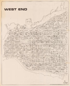
Item is a map showing streets, building footprints, number of storeys, and street codes according to a system adopted by the Engineering Department in the mid-1960s.
Part of City publications collection
Item is a map showing streets, building footprints, number of storeys, topographic contour lines, and street codes according to a system adopted by the Engineering Department in the mid-1960s.

Part of City publications collection
Item is a map showing streets, building footprints and number of storeys.

Part of City publications collection

Vancouver Parks and Recreation : map and guide
Part of City publications collection
Part contains a map of Vancouver showing major roadways and locations of attractions advertised in the pamphlet, a map of Stanley Park in more detail, and textual information on Stanley Park and Vancouver beaches.
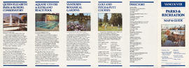
Vancouver Parks and Recreation : map and guide
Part of City publications collection
Part contains information about Vancouver attractions including Queen Elizabeth Park, the Vancouver Aquatic Centre, VanDusen Botanical Gardens, and golf courses.

Vancouver Parks and Recreation : a guide to services
Part of City publications collection

Vancouver Parks and Recreation : a guide to services
Part of City publications collection

Part of City publications collection

Vancouver harbour potential wharfage and trackage areas
Part of City publications collection

Part of City publications collection
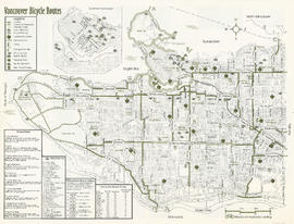
Part contains a map of the north half of Vancouver (Burrard Inlet to 22nd Avenue) showing bicycle routes, parks, and SkyTrain stations, and textual information on downtown bicycle parking and combining cycling with public transit.

Part of City publications collection
Part contains a map of Vancouver bicycle routes with a key to attractions, bridges and ferries, and downtown bicycle parking locations. An inset map shows Downtown Vancouver in more detail.
Part of City publications collection
Part contains a map of Vancouver bicycle routes with a key to attractions, bridges and ferries, and downtown bicycle parking locations. An inset map shows Downtown Vancouver in more detail.

Part of City publications collection
Part contains a map of the south half of Vancouver (22nd Avenue to the Fraser River) showing bicycle routes, parks, and SkyTrain stations, a list of useful contacts for cyclists, and information on bridges and connections.

Stanley Park map and guide : park map showing trails, amenities, and recreation sites
Part of City publications collection
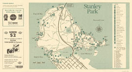
Stanley Park map and guide : park map showing trails, amenities, and recreation sites
Part of City publications collection

Stanley Park map and guide : park history, food services, and general information
Part of City publications collection

Stanley Park map and guide : park history, food services, and general information
Part of City publications collection
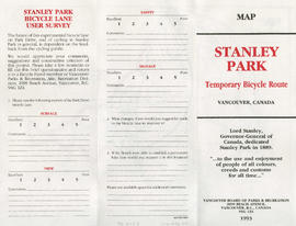
Stanley Park bicycle lane user survey
Part of City publications collection

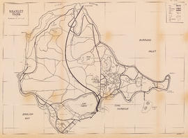
Stanley Park : map showing temporary bicycle route
Part of City publications collection
Part of City publications collection
Item is a map showing roads, trails, walkways, parking lots, buildings, shorelines, creeks, and swamps in Stanley Park.
![Sheet 9D [Slocan Street to Grandview Highway to Marshall Street to 22nd Avenue]](/uploads/r/null/b/1/c/b1c4c0bbf98c9c2ff5a2e60e8350582f0e591688b2f9670ba1f4aaecc638b227/7e2aefcc-f31d-4c11-a0ae-1293bd850528-LEG1153_142.jpg)
Sheet 9D [Slocan Street to Grandview Highway to Marshall Street to 22nd Avenue]
Part of City publications collection
![Sheet 9C [Hull Street/Semlin Drive to 14th Avenue to Clark Drive to 22nd Avenue]](/uploads/r/null/b/4/8/b48f272549a65e8622204f5c1a677afad16a9ef19306e9696b31ef6d9c08cf16/c56229a4-c4b1-492d-b215-b5b53f060d69-LEG1153_142.jpg)
Sheet 9C [Hull Street/Semlin Drive to 14th Avenue to Clark Drive to 22nd Avenue]
Part of City publications collection
![Sheet 9B [Slocan Street to 6th Avenue to Semlin Drive to 14th Avenue]](/uploads/r/null/b/7/5/b75c61b603e8ab998f68941a380457aeae4de4affd845d40405472b07f3738a2/140ef05a-e687-4959-a97a-2765c7610a3c-LEG1153_142.jpg)
Sheet 9B [Slocan Street to 6th Avenue to Semlin Drive to 14th Avenue]
Part of City publications collection
![Sheet 9A [Semlin Drive to 6th Avenue to Clark Drive to 14th Avenue]](/uploads/r/null/4/b/8/4b83338cc19b64deb790aac94219d77731e8a711697a611a458656793c63ccda/f3604bbf-e839-474f-a033-6569d2f2d2e0-LEG1153_142.jpg)
Sheet 9A [Semlin Drive to 6th Avenue to Clark Drive to 14th Avenue]
Part of City publications collection
![Sheet 8D [Slocan Street to Charles Street to Semlin Drive to 6th Avenue]](/uploads/r/null/9/f/b/9fb954e03525c1c5f3722cf6d1f3b0e0d9ae28c2a0ed307fa25ca0dc6ac46434/416c089e-39ae-49d3-a4fc-472175911de5-LEG1153_142.jpg)
Sheet 8D [Slocan Street to Charles Street to Semlin Drive to 6th Avenue]
Part of City publications collection
![Sheet 8C [Semlin Drive to Charles Street to Clark Drive to 6th Avenue]](/uploads/r/null/d/e/5/de5abd94c03b4822da51cf8852f7964a5c39823d701d98d5ba364c57d8b08feb/9a85980c-5f83-4684-b501-ff546226a417-LEG1153_142.jpg)
Sheet 8C [Semlin Drive to Charles Street to Clark Drive to 6th Avenue]
Part of City publications collection
![Sheet 8B [Slocan Street to Pender Street to Semlin Drive to Charles Street]](/uploads/r/null/3/5/4/354478b1921f42f9f80b25d890823ee2c6ef900b23fe032c8504bdf3e7ae0a68/4d6f04e3-89d1-4093-8da7-9692b235a110-LEG1153_142.jpg)
Sheet 8B [Slocan Street to Pender Street to Semlin Drive to Charles Street]
Part of City publications collection
![Sheet 8A [Semlin Drive to Hastings Street to Clark Drive to Charles Street]](/uploads/r/null/c/e/1/ce14d71e20eb294141c9dd954f1318d51d5f7a7cd55238a25a046162a7080d15/a477e80d-6d23-4d54-9c01-cb4ffe87796e-LEG1153_142.jpg)
Sheet 8A [Semlin Drive to Hastings Street to Clark Drive to Charles Street]
Part of City publications collection
![Sheet 7D [Slocan Street to Cambridge Street to Semlin Drive to Pender Street]](/uploads/r/null/b/8/5/b85f2b7f19d9d3491a53e8b9ef51fee071ca3fc6774cda1d9d9550e2ecae1d37/516885bd-701c-4a0b-90ef-fb2768ed0084-LEG1153_142.jpg)
Sheet 7D [Slocan Street to Cambridge Street to Semlin Drive to Pender Street]
Part of City publications collection
![Sheet 7C [Semlin Drive to Burrard Inlet to Clark Drive to Hastings Street]](/uploads/r/null/e/8/7/e87f1b836e88849bba468bcf8aaacb8ad218aa467eb291cb406c557b30a44f53/e7b14ec1-7002-44ea-a4d9-a4a408d2f078-LEG1153_142.jpg)
Sheet 7C [Semlin Drive to Burrard Inlet to Clark Drive to Hastings Street]
Part of City publications collection
![Sheet 7B [Slocan Street to Burrard Inlet to Wall Street to Cambridge Street]](/uploads/r/null/9/a/0/9a0201695d105ce35f3ebe2ff7e982467eb8a211258d83a9894bad340bc1219e/d391f25d-7a0e-4b8d-a3ed-529aed04004a-LEG1153_142.jpg)
Sheet 7B [Slocan Street to Burrard Inlet to Wall Street to Cambridge Street]
Part of City publications collection
![Sheet 6D [Boundary Road to 61st Avenue to Kinross Street to Ellis Avenue]](/uploads/r/null/c/a/1/ca18897f165b8c9fc64a0a090824a17dd124c7fd9eaa4b86b2ef3043e96ae6da/0f219d9c-5616-4b1e-8103-33d6770ccf02-LEG1153_142.jpg)
Sheet 6D [Boundary Road to 61st Avenue to Kinross Street to Ellis Avenue]
Part of City publications collection
![Sheet 6C [Doman Street to 61st Avenue to Jellicoe Street to railway right-of-way]](/uploads/r/null/0/1/2/012976cfb4b4852f4b51cf284a1af29b28e855331a360ce98aa998c853334763/da2a784f-bd89-4cf2-bb2e-44e0568ced3d-LEG1153_142.jpg)
Sheet 6C [Doman Street to 61st Avenue to Jellicoe Street to railway right-of-way]
Part of City publications collection
![Sheet 6B [Boundary Road to 52nd Avenue to Doman Street to 61st Avenue]](/uploads/r/null/2/3/2/2320f1235e898d9e510839eb4408e0746654e3df66acd70352f78e35c1f83fe4/a427c08e-09a5-4e9f-adbd-6f81d49fe16f-LEG1153_142.jpg)
Sheet 6B [Boundary Road to 52nd Avenue to Doman Street to 61st Avenue]
Part of City publications collection
![Sheet 6A [Doman Street to 52nd Avenue to Vivian Street to 61st Avenue]](/uploads/r/null/6/8/b/68b456da543f104f4daefa87e7c0ddbd6dbb5db25e3239ded4652d327398b023/092d539d-4c5c-4406-b26f-1fa7e217b791-LEG1153_142.jpg)
Sheet 6A [Doman Street to 52nd Avenue to Vivian Street to 61st Avenue]
Part of City publications collection
![Sheet 5D [Boundary Road to 45th Avenue to Doman Street to 52nd Avenue]](/uploads/r/null/9/a/5/9a56c23cc8d5ad437bb7063cd9cf0f954bc1d67724ef20861270160771809b4c/d7777803-4376-423c-a5d5-8a44ed84aee7-LEG1153_142.jpg)
Sheet 5D [Boundary Road to 45th Avenue to Doman Street to 52nd Avenue]
Part of City publications collection
![Sheet 5C [Doman Street to 45th Avenue to Vivian Street to 52nd Avenue]](/uploads/r/null/0/f/4/0f44f7b43fd58c096ccc443d651cbc43d9aadeac3e13e7b6863a8914a79bd80d/1486eb87-cda0-4a49-b822-95368cce1f7a-LEG1153_142.jpg)
Sheet 5C [Doman Street to 45th Avenue to Vivian Street to 52nd Avenue]
Part of City publications collection
![Sheet 5B [Boundary Road to Euclid Avenue to Joyce Street to 45th Avenue]](/uploads/r/null/b/d/a/bdaaca7a1a5c9f9359248cc9d383c63ffcf8800e719c0cf177f45dd4bac3cb61/e97627da-8e6c-4ebc-87bd-d46130b9261d-LEG1153_142.jpg)
Sheet 5B [Boundary Road to Euclid Avenue to Joyce Street to 45th Avenue]
Part of City publications collection