Showing 332 results

Archival description
City publications collection With digital objects English
Print preview View:
Feeding your baby the first year
Existing service stations, retail shopping centres and commercial zoning : a basis for regulating...
Existing service stations, retail shopping centres and commercial zoning : a basis for regulating location of service stations
Eric's video
Eric's video
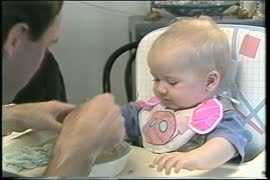
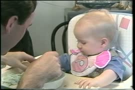
Eating for a healthy baby
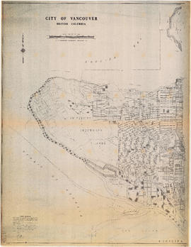
Downtown peninsula - Vancouver, B.C. : contour lines at 10 foot intervals, datum line - 100
Downtown peninsula
Downtown peninsula
Cycling in Vancouver
Commodities shipped overseas through Port of Vancouver
City of Vancouver, British Columbia : Point Grey to Cypress Street
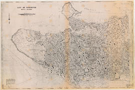
City of Vancouver, British Columbia : Cypress Street to Boundary Road
City of Vancouver, British Columbia : 1981 census of Canada
City of Vancouver, B.C. area map : western boundary with University Endowment Lands to Camosun St...
City of Vancouver, B.C. area map : western boundary with University Endowment Lands to Camosun Street and English Bay to 16th Avenue; Musqueam Indian Reserve no. 2
City of Vancouver, B.C. area map : Wallace Street to Cartier Street and 49th Avenue to the North ...
City of Vancouver, B.C. area map : Wallace Street to Cartier Street and 49th Avenue to the North Arm of the Fraser River
City of Vancouver, B.C. area map : Maple Street to Heatley Avenue and Burrard Inlet to 6th Avenue
City of Vancouver, B.C. area map : Inverness Street to Boundary Road and 32nd Avenue to 54th Avenue
City of Vancouver, B.C. area map : Inverness Street to Boundary Road and 2nd Avenue/5th Avenue to...
City of Vancouver, B.C. area map : Inverness Street to Boundary Road and 2nd Avenue/5th Avenue to 32nd Avenue
City of Vancouver, B.C. area map : Inverness Street to Boundary Road 54th Avenue to the North Arm...
City of Vancouver, B.C. area map : Inverness Street to Boundary Road 54th Avenue to the North Arm of the Fraser River
City of Vancouver, B.C. area map : Heatley Avenue to Boundary Road and Burrard Inlet to 2nd Avenu...
City of Vancouver, B.C. area map : Heatley Avenue to Boundary Road and Burrard Inlet to 2nd Avenue/5th Avenue
City of Vancouver, B.C. area map : Granville Street to Inverness Street and 6th Avenue to 37th Av...
City of Vancouver, B.C. area map : Granville Street to Inverness Street and 6th Avenue to 37th Avenue
City of Vancouver, B.C. area map : Granville Street to Inverness Street and 37th Avenue to 57th A...
City of Vancouver, B.C. area map : Granville Street to Inverness Street and 37th Avenue to 57th Avenue
City of Vancouver, B.C. area map : Discovery Street to Granville Street and English Bay to King E...
City of Vancouver, B.C. area map : Discovery Street to Granville Street and English Bay to King Edward Avenue
City of Vancouver, B.C. area map : Cartier Street to Inverness Street and 57th Avenue to the Nort...
City of Vancouver, B.C. area map : Cartier Street to Inverness Street and 57th Avenue to the North Fork of the North Arm of the Fraser River
City of Vancouver, B.C. area map : Camosun Street to Granville Street and King Edward Avenue to 4...
City of Vancouver, B.C. area map : Camosun Street to Granville Street and King Edward Avenue to 49th Avenue
City of Vancouver, B.C. : curb ramp locations
City of Vancouver, B.C.
City of Vancouver : land use 1984
City of Vancouver : 1986 census of Canada
A Study in Black and White : an economic strategy for Vancouver in the 1980's
Results 301 to 332 of 332