![[Ancient carved stone]](/uploads/r/null/a/8/a885cd350adb2dc3aa635fd0e9ceac8004163ad1012a676f30f255c5e59c8435/2a1f7f6f-09c7-4338-aab3-3ac75b149e0d-A26485_142.jpg)
- AM54-S4-: In P132.2
- Item
- Jan. 24, 1929
Part of Major Matthews collection
33 results with digital objects Show results with digital objects
Part of Major Matthews collection
![[Ancient carved stone artefact from the Marpole midden]](/uploads/r/null/6/1/61e14290ffac47c1ce2c7ec206697876b1d72ee63b8793d5e407cfa1b9dff8e8/d8b81f14-1c00-43e6-bb16-f3b0a60dc15e-A26484_142.jpg)
[Ancient carved stone artefact from the Marpole midden]
Part of Major Matthews collection
![[Ancient carved stone from Katsie near Port Hammond]](/uploads/r/null/d/5/d507b54d29b433aefe4524f12be4cf39b4e3ff8328791e4c1506377ecca98ad9/2f6e08ea-7910-4986-b7de-00c886c49a63-A26486_142.jpg)
[Ancient carved stone from Katsie near Port Hammond]
Part of Major Matthews collection

Part of City of Vancouver Archives technical and cartographic drawing collection

Burrard Inlet - Dollarton sheet
Part of City of Vancouver Archives technical and cartographic drawing collection

Burrard Inlet - Port Moody sheet
Part of City of Vancouver Archives technical and cartographic drawing collection

Burrard Inlet - Second Narrows sheet
Part of City of Vancouver Archives technical and cartographic drawing collection

Burrard Inlet - triangulation control
Part of City of Vancouver Archives technical and cartographic drawing collection

Burrard Inlet - Vancouver sheet
Part of City of Vancouver Archives technical and cartographic drawing collection
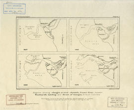
Diagram showing changes in river channels, Fraser River
Part of Harry Patten Archibald fonds
Item is a map sheet containing four maps, each depicting the topography of the river channels at the mouth of the Fraser River, in 1827, 1860, 1890 and 1919.
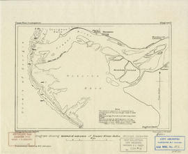
Diagram showing seaward advance of Fraser River delta, British Colmbia
Part of Harry Patten Archibald fonds

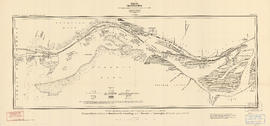
Diagram showing the distribution of surface deposits, Fraser River delta, British Columbia
Part of Harry Patten Archibald fonds

Discharge data, Fraser River, British Columbia
Part of Harry Patten Archibald fonds
Float observations, ebb tidal and river currents, Fraser River
Part of Harry Patten Archibald fonds

Float observations, flood-tidal currents
Part of Harry Patten Archibald fonds

Fraser River - Annacis Island sheet
Part of City of Vancouver Archives technical and cartographic drawing collection

Fraser River - Deas Island sheet
Part of City of Vancouver Archives technical and cartographic drawing collection

Part of City of Vancouver Archives technical and cartographic drawing collection

Fraser River - New Westminster sheet
Part of City of Vancouver Archives technical and cartographic drawing collection

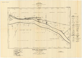
Fraser River - Port Mann sheet
Part of City of Vancouver Archives technical and cartographic drawing collection

Fraser River - Sand heads sheet
Part of City of Vancouver Archives technical and cartographic drawing collection

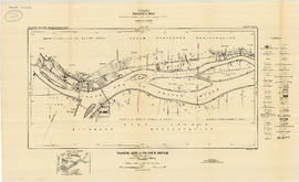
Fraser River - Steveston sheet
Part of City of Vancouver Archives technical and cartographic drawing collection

Fraser River - Tilbury Island sheet
Part of City of Vancouver Archives technical and cartographic drawing collection

Fraser River - triangulation control
Part of City of Vancouver Archives technical and cartographic drawing collection
Fraser River Delta, British Columbia
Part of City of Vancouver Archives technical and cartographic drawing collection
Item is a map with section showing the geology and topography of the Fraser River Delta region. The map depicts surface deposits and bedrock outcrops over different periods of time. Oil and gas well locations are also included.
Part of City of Vancouver Archives technical and cartographic drawing collection
File consists of 18 maps and 3 sheets of associated triangulation and other survey control data, published by the Geological Survey of Canada. The maps depict a geological survey of the banks, islands, marshes, etc. of the Fraser River, North Arm of the Fraser River and Burrard Inlet.
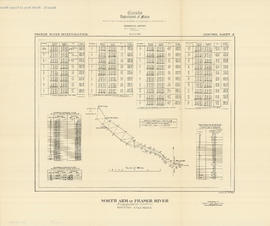
Fraser River investigation maps and diagrams
Part of Harry Patten Archibald fonds
File consists of a group of maps and charts of associated data from the Fraser River Investigation by the Geological Survey of Canada.

Geological map of parts of Nanaimo and New Westminster mining divisions
Part of City of Vancouver Archives technical and cartographic drawing collection
Item is a map showing Tertiary, Mesozoic, and Paleozoic areas and includes descriptive notes. Map drawn "To illustrate report by O. E. Leroy, M. Sc., 1906."
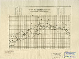
High water data at Mission Bridge (freshet stages), Fraser River, British Columbia
Part of Harry Patten Archibald fonds
Item is a sheet which includes lists of spring flood highest water data from 1876 to 1920, as well as a graph of the data.
North Arm of Fraser River - Boundary Road sheet
Part of City of Vancouver Archives technical and cartographic drawing collection

North Arm of Fraser River - Ione Island sheet
Part of City of Vancouver Archives technical and cartographic drawing collection
North Arm of Fraser River - Marpole sheet
Part of City of Vancouver Archives technical and cartographic drawing collection

North Arm of Fraser River - Point Grey sheet
Part of City of Vancouver Archives technical and cartographic drawing collection

North Arm of Fraser River - Poplar Island sheet
Part of City of Vancouver Archives technical and cartographic drawing collection
North Arm of Fraser River - triangulation control
Part of City of Vancouver Archives technical and cartographic drawing collection
Report of Progress for 1842-1884.
Report is a geological reconnaissance, No. 980.

River and sea-bottom materials, water density observations and bank erosion, Fraser River
Part of Harry Patten Archibald fonds