Item is a reproduction of a map which depicts North America, South America and the West Indies. An inset map on the lower left-hand corner shows Baffin Island and Hudson's Bay. The item also includes lists of islands and regions in the Americas belonging to each of Great Britain, France, Spain, Portugal, Denmark and the Dutch, as per the terms of the Treaty of Paris. The item also includes a list of nine relevant articles defined in the 1763 Paris treaty.
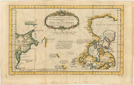
Item is a map engraved by French cartographer M. Bellin showing eastern Asia and the northern part of North America, mainly Canada. Includes notes as to areas of the west coast of North America explored by the Russians in 1728 and 1741, the exploration of the entrance of the Strait of Juan de Fuca in 1592 and 1603, as well as exploration on the east coast of Asia. Map also includes latitudes and longitudes, some place names, major bodies of water and indicates mountainous regions. Printed on the bottom of the map is "Tome XV" and "No. 4."
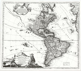
Item is a reproduction of a map depicting North America, Central America, South America, the southern portion of Greenland, northwestern Europe and northeastern Asia.
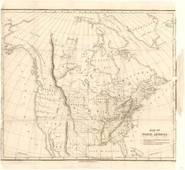
Item is a map showing "Mr. Stuart's route through the United States, and Canada in 1828, 29 & 30" and "the boundary of the United States, both on the side of the British Possessions, & those in Mexico." The northern border of United States territory west of the Rocky Mountains is incorrectly noted at 54/40, to reflect American claims of the time.
Item is a map showing the locations of Russian exploration discoveries around the Pacific coast, as well as some discoveries by other explorers such as Juan de Fuca and Sir Francis Drake. Area shown includes Russia, China, Japan, Northern Ocean, Pacific Ocean and North America. Includes a explanation of Russian names on the map.