
British Columbia. Commercial map of B.C.
Cheakamus Lake

Cheakamus power survey : copy of portion of plan no. 11 accompanying report by E.A. Cleveland
Cheakamus River
Cheakamus River
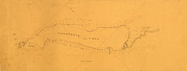
Cheakamus River. Brandywine Creek to Cheakamus Lake
Chehalis River and Harrison Lake
Chehalis River and Harrison Lake

Chilliwack Lake scheme & Jones Lake scheme
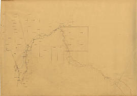
Chilliwack River
Chilliwack River
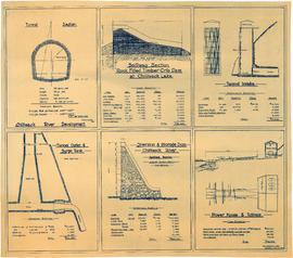
Chilliwack River development

Contour map shewing proposed location of flume, reservoir and power plant Cheakamus River, B.C.

Contour map shewing proposed location of flume, reservoir and power plant Cheakamus River, B.C.

Contours in Chilliwack Valley near Chipmunk Run

Copy sketch map of a portion of the mountains of the Garibaldi Group in the vicinity of Garibaldi Lake
Daisy Lake
Daisy Lake

Dam on Soo River at 4+4980

Garibaldi Lake study 1932-1933
![General plan [of hydro-electric development on Green River]](/uploads/r/null/d/9/e/d9e4c58e28a2189f0c1819b9c491a0478fad0353e2100858ec1eb94c55b96eae/93fa8e5f-c3b7-4e51-802d-979b7bc07f6f-MAP1098_142.jpg)
General plan [of hydro-electric development on Green River]

General plan of proposed development of Alouette water power

General plan of the hydro-electrical power development from the Bridge River, Lillooet District, B.C.

General plan of works to be constructed at Nairn Falls. Green Lake. Lillooet District, B.C.
Green Lake
Green Lake
Green River & Soo River
Green River & Soo River
Green River and Soo River maps and sections
Green River and Soo River maps and sections
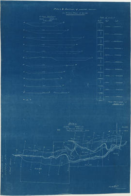
Green River and Soo River profiles and sections
Green River and Soo River profiles and sections
Hydro electric schemes. Squamish River
Hydro electric schemes. Squamish River

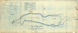
Hydro electric survey. Cheakamus River from Squamish River to Brandywine Creek

Hydro electric survey City of Vancouver : Cheakamus River system from Squamish River to Green River

Hydro electric survey City of Vancouver : Cheakamus River system from Squamish River to Green River

Hydro electric survey Green River to Alpha Lake
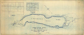
Hydro electric survey. Plan showing preliminary survey of Cheakamus Lake
Hydro electric survey. Plan showing preliminary survey of Cheakamus Lake

Hydro electric surveys. Plan showing location of water powers investigated by City of Vancouver

Hydro electric surveys. Plan showing location of water powers investigated by City of Vancouver

Hydro electric surveys. Preliminary plan of Brandywine Creek
Hydro-electric scheme. Alpha Lake to Green Lake
Hydro-electric scheme. Alpha Lake to Green Lake

Key map shewing territory within which it is desired to sell power
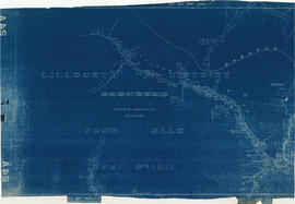
Lillooet District from sale April 6th 1911
![Longitudinal section along [centre line] of dam sites at north end of Green Lake](/uploads/r/null/7/4/a/74af74789da62d7da66c012dd18dd964e4e83151ac5f0b139a53843bce6ccfe6/974ff05f-0f29-4e65-b818-c663b1a236e1-MAP1142_142.jpg)
Longitudinal section along [centre line] of dam sites at north end of Green Lake

Longitudinal section on line of power mains

Lower Lillooet River - Bear Lake to Gowan Creek

Lower Lillooet River - Gowan Creek to Rogers Creek

Lower Lillooet River - Harrison Lake to Tipella trail

Lower Lillooet River - Rogers Creek to Billygoat (29 Mile) Creek

Lower Lillooet River - Tipella trail to Bear Lake
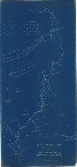
Map of headwaters of Cheakamus and Green rivers

Map shewing proposed pole line of British Columbia Power and Electric Co. from Cheakamus River to Vancouver

Map showing stream gauging status
Plan & sections of possible reservoir on Green River

Plan and profile from Cultus Lake to Vedder Crossing

Plan and profile from Cultus Lake to Vedder Crossing