![[West Pender Street and Hamilton Street - Victory Square]](/uploads/r/null/f/0/6/f065b2280bfb1c913d281237d2a00ce47630382f92bd8a22e0ce60ffaba96a8c/3055b6f8-a905-4ef6-b549-b7f42affe4b7-CVA1095-09232_142.jpg)
[West Pender Street and Hamilton Street - Victory Square]
- COV-S644-: CVA 1095-09232
- Item
- [between 1964 and 1973]
Part of City of Vancouver fonds
463 results with digital objects Show results with digital objects
[West Pender Street and Hamilton Street - Victory Square]
Part of City of Vancouver fonds
![[West Pender Street and Hamilton Street - Victory Square]](/uploads/r/null/e/f/8/ef8b15602a4a2ace2ab3b4676164f8fe00870e50b45c40e8205363f6279ddfbc/918646cc-94b0-497b-995f-eb2ec6d416ff-CVA1095-09221_142.jpg)
[West Pender Street and Hamilton Street - Victory Square]
Part of City of Vancouver fonds
![West End Minipark [2 of 2]](/uploads/r/null/0/0/00bdc4e1a75086b90e7c5a73f0a4113cbe79eaa85dce9ce6b924cc8ac29c87aa/58524b1d-5dd5-4e19-b299-82a4da649dd9-A66137_142.jpg)
Part of City of Vancouver fonds
![[View west from 72nd Avenue and Cartier Street - Marpole Park]](/uploads/r/null/5/f/0/5f06152258304d7490c886a5f890b21c4148994d506f6309b74527f4a53ee5c6/76932c13-60cb-4b86-a084-4bb92b57d8bc-CVA1095-07308_142.jpg)
[View west from 72nd Avenue and Cartier Street - Marpole Park]
Part of City of Vancouver fonds
![[View south from 72nd Avenue and Cartier Street - Marpole Park]](/uploads/r/null/5/6/b/56bdbdb2ec992c3b888762b016de32cc2edbb4aee73c8a3ba9bb130d606ebd32/c3897c44-5625-4645-86ed-2f48078654e4-CVA1095-07307_142.jpg)
[View south from 72nd Avenue and Cartier Street - Marpole Park]
Part of City of Vancouver fonds
![[View of three houses on Jackson Avenue from the corner of Oppenheimer Park]](/uploads/r/null/5/c/5c8e73d135383cf949fa54a967ceca3bb4897c7513855bf7d95669bbd58b37dc/41c5b4a9-98b2-4d74-8629-9930de792ecc-A59207_142.jpg)
[View of three houses on Jackson Avenue from the corner of Oppenheimer Park]
Part of City of Vancouver fonds
![[View of the seawall and a lighthouse at Stanley Park]](/uploads/r/null/0/8/08c3102e4938f90accff7c8d9d8a39c3da044de310f86e6502e6b5d0b66795ec/848654ce-4006-4914-9079-f02bf3b3d738-A59816_142.jpg)
[View of the seawall and a lighthouse at Stanley Park]
Part of City of Vancouver fonds
![[View of the North Shore from Stanley Park]](/uploads/r/null/e/9/e999f5c9d39dee9b4a91a8f8cedc506e957729af046948792fe9efa2d76d1dec/e86bd79a-e443-45cd-9fd1-fab3b5bf8d93-A59812_142.jpg)
[View of the North Shore from Stanley Park]
Part of City of Vancouver fonds
![[View of Shaughnessy Park, 2 of 2]](/uploads/r/null/5/f/5/5f5f53be79793d6fc67b3e9eb8c6e9d0f14d8fae5d01f3fe4ccbd5e07c19af32/8a4be42a-aff5-4079-9841-5eb614f65eea-CVA1095-03766_142.jpg)
[View of Shaughnessy Park, 2 of 2]
Part of City of Vancouver fonds
![[View of Shaughnessy Park, 1 of 2]](/uploads/r/null/5/5/5/555fd91b074a1e776bd438d7528970231323dd47e6635bccd4d30813f9d42c19/0fc7b09e-377e-4d5d-86f2-5fd7bcf3d009-CVA1095-03765_142.jpg)
[View of Shaughnessy Park, 1 of 2]
Part of City of Vancouver fonds
![[View of pedestrian overpass from Stanley Park Drive]](/uploads/r/null/8/9/b/89b45231ebbdc7b88658ab904a14ec833a3a7e8e13ff6a3add2f949e918c27f4/c1ca0b10-b291-4dbd-93d4-28273ad0cf3f-CVA1095-00666_142.jpg)
[View of pedestrian overpass from Stanley Park Drive]
Part of City of Vancouver fonds
![[View of Oppenheimer Park]](/uploads/r/null/2/b/2bdee6b9ef03a2de5645ca6c7f8c3d1efb22224293704977585b765ebad5d542/637b119d-05db-4095-8976-92723442f7b5-A59236_142.jpg)
Part of City of Vancouver fonds
Photograph shows buildings and businesses along Oppenheimer Park including Fujiya Fish Market (423 Powell Street), Double Happiness Foods Ltd. (427-9 Powell Street) and the Helping Hand Goodwill Store (435 Powell Street). A masked performer can be seen in the park.
![[View of Lions Gate Bridge from Stanley Park]](/uploads/r/null/6/5/e/65eb22cd806d83d976f34f90d16e6df9e406ea4f2cd42f9d8e6cc713442a4435/ed2e6151-010e-4037-ba31-74c9758b7909-CVA1095-00567_142.jpg)
[View of Lions Gate Bridge from Stanley Park]
Part of City of Vancouver fonds

View of Keefer street and corner of high-rise housing in McLean Park, from Dunlevy and Keefer
Part of City of Vancouver fonds
![[View of] Jericho Beach [from Jericho Park]](/uploads/r/null/5/2/525ecae1508aac5fd632548bfde4311377eaa16bbb76b9edda9db2f30b32c89c/1e38cdfc-0845-47f4-879b-6e9f208adcf6-A59304_142.jpg)
[View of] Jericho Beach [from Jericho Park]
Part of City of Vancouver fonds
![[View of HMCS Discovery Naval Reserve from Stanley Park]](/uploads/r/null/9/e/9/9e9024d0849a483f5d256508ebaa432abafc2163307e4bbd8b6c5e5536179d0d/60fd1b1d-6f55-4206-b305-83d3fb553521-CVA1095-00037_142.jpg)
[View of HMCS Discovery Naval Reserve from Stanley Park]
Part of City of Vancouver fonds
Image is a photograph that depicts the HMCS Discovery Naval Reserve visible from Stanley Park. The skyline of downtown Vancouver is visible in the background.
![[View of False Creek and Granville Street Bridge from Vanier Park]](/uploads/r/null/9/d/d/9ddf5905eb08541c1d069d9954c8b4f56285a937204fac4470200f10981c24c3/69589d54-218d-413e-93b3-4d0c5eba4ee3-CVA1095-01069_142.jpg)
[View of False Creek and Granville Street Bridge from Vanier Park]
Part of City of Vancouver fonds
![[View of English Bay and the West End from Stanley Park]](/uploads/r/null/1/e/1ee06fda871d25f8847c00c3c4b6c702e48b44a63f2ad4de67a86b87823ffb9c/04dee418-9e62-484e-8bf1-b3287a13aba5-A59815_142.jpg)
[View of English Bay and the West End from Stanley Park]
Part of City of Vancouver fonds
![[View from the Seawall of Vancouver Rowing Club and Stanley Park]](/uploads/r/null/8/0/6/80696f4a815dcb8544768f85162456fa0949ce657a1401fcdbdd1140e8ee3cae/20aa6748-ad20-4dbb-9687-37a14d749b3e-CVA1095-00024_142.jpg)
[View from the Seawall of Vancouver Rowing Club and Stanley Park]
Part of City of Vancouver fonds
Item is a photograph of the Vancouver Seawall with the Vancouver Rowing Club in the mid ground and Stanley Park in the background.
![[View from Stanley Park of a] vessel passing under[neath the] Lions Gate [First Narrows] Bridge](/uploads/r/null/8/a/8a60cf3c4bece4b8575e03052e5efc73c170f600fea19e73fa5ad6aef2beb21e/8915f3b2-5b79-4e44-812e-a58388f121bb-A59817_142.jpg)
[View from Stanley Park of a] vessel passing under[neath the] Lions Gate [First Narrows] Bridge
Part of City of Vancouver fonds
![[View from Oppenheimer Park of 450 East Cordova Street]](/uploads/r/null/9/e/8/9e8792eac74bb6b5499386a5e86eed6f2b20440e1efdd01cf0fda9838d1c36f3/61beeeef-72a1-424c-91c8-1ef049e45a22-CVA1095-07110_142.jpg)
[View from Oppenheimer Park of 450 East Cordova Street]
Part of City of Vancouver fonds
![[View across Oppenheimer Park from Powell Street, 2 of 2]](/uploads/r/null/c/0/b/c0b989a3de57b7a1fbe4ab7519e21e7357f3c826e60ae5294089e54ddeea5985/e83eae76-d164-4a9f-b7f7-1a126fd00fa9-CVA1095-07109_142.jpg)
[View across Oppenheimer Park from Powell Street, 2 of 2]
Part of City of Vancouver fonds
![[View across Oppenheimer Park from Powell Street, 1 of 2]](/uploads/r/null/e/6/4/e6414cc87bdc15c14f1af4c966e16a3265401c2b85a703e44cc8425e5fe3205a/aa665c2b-e8e8-4961-99c8-741bb91a0b83-CVA1095-07108_142.jpg)
[View across Oppenheimer Park from Powell Street, 1 of 2]
Part of City of Vancouver fonds

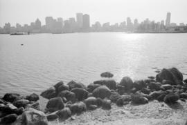
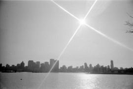
Vancouver skyline, Coal Harbour, and Stanley Park seawall beach
Part of City of Vancouver fonds

Vancouver skyline, Coal Harbour, and Stanley Park seawall beach
Part of City of Vancouver fonds

Vancouver skyline, Coal Harbour, and Stanley Park seawall beach
Part of City of Vancouver fonds
Vancouver skyline, Coal Harbour, and Stanley Park seawall beach
Part of City of Vancouver fonds

Vancouver skyline, Coal Harbour, and Stanley Park seawall beach
Part of City of Vancouver fonds

Vancouver skyline from Stanley Park seawall
Part of City of Vancouver fonds
Item part is a photograph of the downtown Vancouver skyline and waterfront, looking south across Coal Harbour from the seawall path in Stanley Park.

Vancouver skyline from Stanley Park seawall
Part of City of Vancouver fonds
Item part is a photograph of the downtown Vancouver skyline and waterfront, looking south across Coal Harbour from the seawall path in Stanley Park.
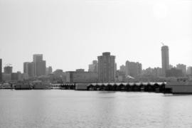
Vancouver skyline and waterfront from Stanley Park seawall
Part of City of Vancouver fonds
Item part is a photograph of the downtown Vancouver skyline and waterfront, looking south across Coal Harbour from the seawall path in Stanley Park. Boat storage units are visible along the coast.
Vancouver skyline and waterfront from Stanley Park seawall
Part of City of Vancouver fonds
Item part is a photograph of the downtown Vancouver skyline and waterfront, looking south across Coal Harbour from the seawall path in Stanley Park. Boat storage units are visible along the coast.

Vancouver skyline and waterfront from Stanley Park seawall
Part of City of Vancouver fonds
Item part is a photograph of the downtown Vancouver skyline and waterfront, looking south across Coal Harbour from the seawall path in Stanley Park. Boat storage units are visible along the coast.
Vancouver skyline and waterfront from Stanley Park seawall
Part of City of Vancouver fonds
Item part is a photograph of the downtown Vancouver skyline and waterfront, looking south across Coal Harbour from the seawall path in Stanley Park. Boat storage units are visible along the coast.

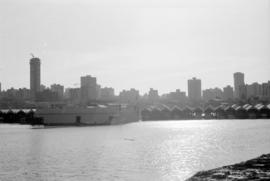
Vancouver skyline and fuel barges from Stanley Park seawall
Part of City of Vancouver fonds
Item part is a photograph of the downtown Vancouver skyline and waterfront, looking south across Coal Harbour from the seawall path in Stanley Park. Several fuel barges (National, Home, and Esso) are visible in the harbour.
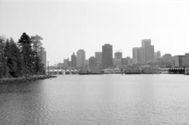
Vancouver skyline and Coal Harbour
Part of City of Vancouver fonds
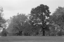
Un-named trees, Sunnyside Park (N.I.I.)
Part of City of Vancouver fonds

Part of City of Vancouver fonds

Part of City of Vancouver fonds

Part of City of Vancouver fonds
![[Traffic underpass beneath entrance to Stanley Park Causeway]](/uploads/r/null/9/9/4/99433957d670990835ccc922d28dee04fbc4e08fab7bd00f15def8d7cc526399/67a9029c-27e6-4eae-887b-d368365d677e-CVA1095-00665_142.jpg)
[Traffic underpass beneath entrance to Stanley Park Causeway]
Part of City of Vancouver fonds
![[Totem poles plaque, Stanley Park]](/uploads/r/null/8/f/c/8fcfcc01c2d1d4b6dbebb00c46a73c364b86579dbc474634aa1c0862d59d2a32/b80aa05e-0b8b-4fe6-8ae1-882b10462729-CVA1095-00582_142.jpg)
[Totem poles plaque, Stanley Park]
Part of City of Vancouver fonds
![Totem [Poles at] Stanley Park](/uploads/r/null/d/f/df8339401708487d00c2f02223ff3d4139faf8d86e78ff1e4cf9f68ac5b48e69/3aee8f5e-ffe5-44e0-a0d6-b3b077370309-A59813_142.jpg)
Part of City of Vancouver fonds
![[Totem Poles at Brockton Point, Stanley Park]](/uploads/r/null/8/4/d/84d691118359e83482ae2e4a6495b2f70abeac043c790751ac4bffbb2520b0e8/a8b6664d-35b0-4835-927b-b5214c2cd430-CVA1095-00036_142.jpg)
[Totem Poles at Brockton Point, Stanley Park]
Part of City of Vancouver fonds
![[Totem Poles at Brockton Point, Stanley Park]](/uploads/r/null/a/5/d/a5d441f6893be8641ae281a6e3bbbc19d3bcb73f65f0ba0ab24c3fedf7f7ff35/ba260943-7458-4ed1-b03e-2092a8b1375a-CVA1095-00035_142.jpg)
[Totem Poles at Brockton Point, Stanley Park]
Part of City of Vancouver fonds
![[Totem Pole, Stanley Park]](/uploads/r/null/6/f/d/6fd8abf07d41d08ad6596d4261ea75100394350311c11dabd4a4ab0c5798e4eb/7a9f298f-c3ba-4786-aaa0-78ad1fcc63dd-CVA1095-00632_142.jpg)
Part of City of Vancouver fonds
![[Totem Pole, Stanley Park]](/uploads/r/null/1/6/6/1664b67b7810646950d68c0a93230e5ae94594e8fecd733568db1d10482aba62/1200c52a-8798-462c-8660-aa477dfb9010-CVA1095-00636_142.jpg)
Part of City of Vancouver fonds
![[Totem Pole at Brockton Point, Stanley Park]](/uploads/r/null/e/3/b/e3b371e10331d89c0f6ba37e2b4cc5f72961720d9ad749dd6b37a6842dee355d/b34218e3-ef2a-47b1-ab72-ba7cafaae0b7-CVA1095-00568_142.jpg)
[Totem Pole at Brockton Point, Stanley Park]
Part of City of Vancouver fonds

Thornton Park, southern portion, looking west toward Expo site - 4 Catalpas
Part of City of Vancouver fonds

Thornton Park, northern portion, looking northwest
Part of City of Vancouver fonds