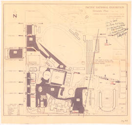
Pacific National Exhibition grounds plan : parking available for proposed arena
Page from "The Buzzer," November 26, 1937, showing map of bus routes
Panoramic view of the City of Vancouver, British Columbia, 1898
Pictorial map of Greater Vancouver showing dates of settlement in specific areas and opening dates of regional landmarks
Plan 3
Plan no. 2 : showing city distribution system, pressure districts, fire stations and water flow test locations : City of Vancouver, British Columbia
Plan of a portion of the water front of Vancouver city
Plan of Cambie St. grounds
Plan of district lot boundaries, City of Vancouver, B.C.
Plan of district lot boundaries, City of Vancouver, B.C. [index map]
Plan of Greater Vancouver, British Columbia
Plan of part of D.L. 540
Plan of part of sub-division of district lot 540, South Vancouver, provincial government property
Plan of Point Grey Municipality
Plan of Point Grey Municipality
Plan of Point Grey Municipality
Plan of portions of False Creek (Kitsilano) Indian Reserve, Vancouver, B.C., required for Burrard Street Bridge right-of-way
Plan of Provincial Government property being a portion of Townsite of Vancouver
Plan of provincial government property being a portion of townsite of Vancouver and sub-division of lot 540, group 1, New Westminster District, B.C., to be sold by public auction at Vancouver, B.C.

![Municipality of North Vancouver [Burrard Inlet]](/uploads/r/null/6/d/6d0d9a4b75b38672c56aa89a5984fe2d0e6d66be85f6f375cbe8e2fd7ac94a98/577914e1-3de2-478b-a629-5f391731387a-MAP588_142.jpg)


![Plan of district lot boundaries, City of Vancouver, B.C. [index map]](/uploads/r/null/9/4/9469805f0ad98fa8c476e2fa1bd641a165448bbfe6840da2ca337894637001a4/9199ff56-1884-4c1f-8d1c-1a513de71a3d-MAP779_142.jpg)


![Plan of re-subdivision of lots 3 to 14, subn [subdivision] 2 of bk [block] 3. D.L. 391 & 392](/uploads/r/null/4/a/4a0ea6aa076433c7bcad0c847f7acb3bb1046f7abf2801c48b97d9ca58f49a73/9bd508e4-c85e-4090-b266-27571c5d4dbc-MAP754_142.jpg)


![Plate 10 [CPR yards between Pender Street and Georgia viaduct]](/uploads/r/null/4/d/f/4df4324d57fa032950845b1be5ae2e04c2707c20e598bf307101a36ba7929130/176fae2d-a49c-4f75-99db-5ec876a739ce-1972-582_142.jpg)
![Plate 10: West End [Thurlow Street - Nelson Street - Cardero Street - Burnaby Street]](/uploads/r/null/e/b/2/eb281da970ebd644483c0c62bac6df4efa77211537470a4acc06ddf0dfdfca64/aee7ff8d-629b-4876-aa73-91222025ab9b-MAP342a_142.jpg)
![Plate 101 [Alberta Street to False Creek to Bridge Street to Fifth Avenue]](/uploads/r/null/3/a/c/3ac4671c467690486217deca7d5b3609b605b6fc542b79fb134372abed97a952/1e879c50-27f7-4e55-8d48-ae8d72b27441-1974-100_142.jpg)
![Plate 102 [Front Street to False Creek to Cambie Street Bridge]](/uploads/r/null/2/3/4/23495fedf0cfd0840f946ff51151c2d620ac4381afedbd39cc496162211c108a/798a5687-2c56-4add-bf27-5adb8e27ebeb-1974-100_142.jpg)
![Plate 103 [Manitoba Street to False Creek to Dufferin Street]](/uploads/r/null/0/8/7/0878dcb1525256aa0f6a2ddfe63ea87046dd130caf68b3d7632593fb9d0e805f/b9950050-5631-4c4c-ac19-d2f7d1e8440a-1974-100_142.jpg)
![Plate 104 [Quebec Street to False Creek to Manitoba Street to Dufferin Street]](/uploads/r/null/b/3/b/b3b42c0352bed859e94ea30004ddb12475eea99c16a153542be22e644023b5ac/98b44bb6-b7b2-4f4c-aa2e-1d090030146e-1974-100_142.jpg)
![Plate 105 [Front Street to False Creek to Quebec Street to Dufferin Street]](/uploads/r/null/a/f/b/afbb9be25514350d408eefa5865173e3a489ecdb6752d6b3096564052b234ca4/8c126ea6-16bb-4f0b-8131-a16f2a686d95-1974-100_142.jpg)
![Plate 106 [Manitoba Street to Dufferin Street to Alberta Street to Fifth Avenue]](/uploads/r/null/a/2/8/a288bcdc881a84d269c058cb38c117c43ef34c68d4a36dd1ffa72bfc2a46ba60/2d5baff6-456c-4406-9faf-fdd562e492b0-1974-100_142.jpg)
![Plate 107 [Quebec Street to Dufferin Street to Manitoba Street to Fifth Avenue]](/uploads/r/null/0/d/7/0d79d0f2e59b2acf6f0b094b86112948aced989bd8c13eb8f8ac17f5cb05a1fd/b74906fe-c1a9-49b1-8bc5-37b4141108f6-1974-100_142.jpg)
![Plate 108 [Scotia Street to Front/Dufferin Streets to Quebec Street to Fifth Avenue]](/uploads/r/null/5/4/6/54625ed1d1a99824d0a91f9897950dc4d1691ce8f7fae7be8086e768e671ef0e/5da48b46-8a62-40b9-9992-0fcbe4e8b491-1974-100_142.jpg)
![Plate 109 [Victoria Drive to False Creek to Scotia Street to Fifth Avenue]](/uploads/r/null/c/f/7/cf796986affb1d4761889c3b98c83be508ab7b762a16dcde3f48354e496a910f/3e0ce046-091f-45fb-b3ec-8ef8d907b4c2-1974-100_142.jpg)
![Plate 11: Downtown [Homer Street - Georgia Street - Thurlow Street - Burnaby Street/Drake Street]](/uploads/r/null/5/b/d/5bdf92b6d2c774df0db66b41942f3eacb7f3ac265aeefeac99ba2fe6be2377b8/42419aa4-f47a-47ec-870b-3fdab1496d88-MAP342a_142.jpg)
![Plate 11 [Great Northern, Canadian Pacific and BC Electric rail wards south of Pender Street]](/uploads/r/null/e/3/8/e3845e99a86b7c63562774d7ac49596466047a1ef5d4daf1ede5be765cc5f434/7338b83f-7dd7-4768-832b-57a4c33a7cc2-1972-582_142.jpg)
![Plate 110 [Carolina Street to False Creek to Victoria Drive to Seventh Avenue]](/uploads/r/null/9/c/d/9cde1416ae9e7694bef6c49f29ddb6e0e736b4639ac4c5dfd11bc2ba91e0e05e/c91e3418-bc09-4b26-a8c5-2adaccfe4aa1-1974-100_142.jpg)