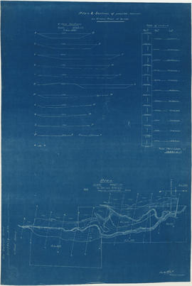
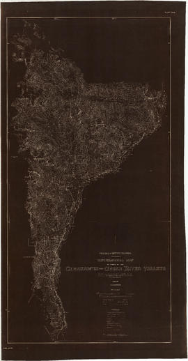
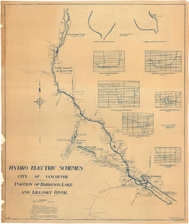
Item is a map sheet survey data from Lilloet Lake in the north to Harrison Lake in the south. The main map show potential dam sites, water levels, bridges and wagon roads. Significant bodies of water included on the map are Harrison Lake, Little Harrison Lake, Glacier Lake, Fire Lake, Lilloet lake, Little Lillooet or Tenas Lake, and Lillooet River. Also shown are Billy Goat Creek, 25 Mile Creek, Rogers Creek, Gowan Creek, Glacier Creek, Spriny Creek, Tipella Creek, Douglas Creek and 6 1/2 Mile Creek. The sheet includes two nautical charts showing depth soundings at the south end of Lillooet Lake and the south end of Tenas Lake. The six sections show depth measured along points on the Lillooet River.


![South Foot of Gladstone - Fraser River. Pe. [6 of 6]](/uploads/r/null/d/8/d8bf0e36d9422f4ba2a2e4909aee66ac86853b4a985089c8f82e09fe887aa908/15f96b9b-1e11-4f26-b546-f88eb7e29613-A66112_142.jpg)
![South Foot of Gladstone - Fraser River. Pe. [5 of 6]](/uploads/r/null/b/3/b3f83d66eddcf619f8295aedd235345e4b5db71a48ced9c626f69252ba21d064/e69ff05f-dced-4eaa-8157-14fec3cb3b95-A66111_142.jpg)
![South Foot of Gladstone - Fraser River. Pe. [4 of 6]](/uploads/r/null/7/f/7f1b88ad2ecb391ca4b36ebc14a93c8c2862ae4ef2cbd2977707fc22311946a1/a0add406-3d1b-4c9e-83dd-c8eb36ff715e-A66110_142.jpg)
![South Foot of Gladstone - Fraser River. Pe. [3 of 6]](/uploads/r/null/1/6/1638f456e571ed49d1a72a442d88284427ffba65adfe35fdd612dfeb2085b9dd/868f28ee-bfa4-4b8c-bc4d-14bdf8d5e864-A66109_142.jpg)
![South Foot of Gladstone - Fraser River. Pe. [2 of 6]](/uploads/r/null/1/8/18ab0dcb4667db381a4fe3432bf81e618ab99ca636681fe662613c88dd2c5678/d79fcf70-2a93-4d54-b48b-bcb2c911c860-A66108_142.jpg)
![South Foot of Gladstone - Fraser River. Pe. [1 of 6]](/uploads/r/null/e/9/e9301ed38f489df2140e46359e84eaa6e5f343c18a7a3b1564b5ec1ebdf27565/95a46084-de34-4a1a-98f3-318e52bb4cac-A66107_142.jpg)


![Rivers [3 of 3]](/uploads/r/null/2/2/22f9e1f2207335e27d02a704d8cc7f7f40b99734c6065a3261b1f9f743090885/326499ae-df91-47d3-91e5-ea5c1e0327ca-A64288_142.jpg)
![Rivers [2 of 3]](/uploads/r/null/1/1/112ea7005acea26763c0a65b7cdd5aa53822bc6ca6805830032bc17343033a81/43521d2b-17be-420f-91e4-5f2d57c80c9a-A64287_142.jpg)
![Rivers [1 of 3]](/uploads/r/null/8/8/88bfdb2f04e58a973344a89e5e8798f35ffcf5cd9b114555b49482957527fc3d/7efecb0e-07fc-42ff-a91a-083417003c18-A64286_142.jpg)


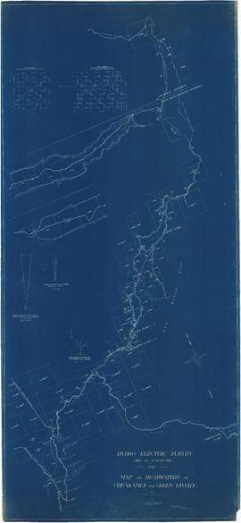
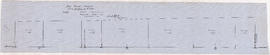
![Profile of Lillooet River between Lillooet & Tenasse [Tenas] Lake](/uploads/r/null/7/b/8/7b86c7530348c631fba136d04e4b31b414065b7e3f90c8000f45b0b3cc1242c8/bfb1c164-5e71-45ae-add4-e17ffd8c8272-MAP1140_142.jpg)


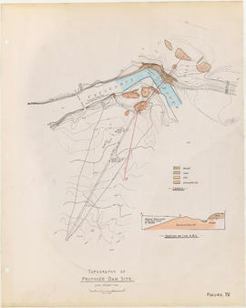
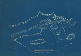
![Plan of fore bay [Nairn Falls hydro electric development]](/uploads/r/null/a/5/5/a55f94fc41cdf02e4a01434daeaf4b6c8715d61bd2a3842a95887e8c7f3371d0/29aba9ea-44a6-4453-9451-4896c8923762-MAP1099_142.jpg)