Wrigley's new revised map of Vancouver
- AM738-S1-: MAP 695
- Item
- 1947
Item is a street map of Vancouver, with a street index on the verso.
63 results with digital objects Show results with digital objects
Wrigley's new revised map of Vancouver
Item is a street map of Vancouver, with a street index on the verso.

Wrigley's new revised map of Vancouver
Part is the front side of a map, which shows proposed roads, street car lines, bus lines, railways, electric railways, golf courses, block numbers, parks, hospitals and schools
Item shows road names and block numbers.

Item is a map of Greater Vancouver showing streets, parks, schools and hospitals; includes street index.

Map shows a street plan in Vancouver according to the following: major streets of sufficient width, major streets to be widened, new major street connections, proposed express highways, scenic drives, boulevard drives, parkways and proposed major streets in the University Endowment Lands. The map also indicates the number of traffic lanes in each street.
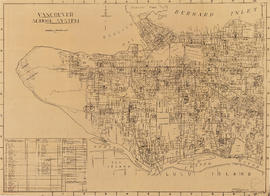
Item is a copy of a City of Vancouver Planning Department map showing the locations of schools in Vancouver's public school system.
Transit system map of Greater Vancouver, B.C.

Transit system map of Greater Vancouver, B.C.
Part consists of a map showing trolley coach lines, bus lines, street car lines, interurban lines, interurban stops, route numbers, B.C. Electric installations and block numbers in West Vancouver, North Vancouver, Vancouver, Burnaby and the University Endowment Lands.

Transit detail inset maps ; Street index ; Transit and tourist information
Part consists of three maps showing transit details in Richmond, New Westminster and downtown Vancouver, and descriptive information about B.C. Electric routes and services and Greater Vancouver attractions.
The District of West Vancouver [right half]
The District of West Vancouver [left half]
The District of West Vancouver
The District of West Vancouver
The District of West Vancouver
File consists of a map of West Vancouver copied in two parts.
The District of West Vancouver
The District of West Vancouver
The District of West Vancouver
Item shows contours, street names, and legal descriptions, including annotations.
Subdivision plan of parcel 'X' District Lot 278
Item is the subdivision plan for the area bounded by Victoria Drive, 55th Avenue, Argyle Street and 61st Avenue. The map shows subdivision of Fraserview lands owned by the Canadian Mortage and Housing Corporation.
Dominion Map Limited (Vancouver, B.C.)
Street map of Vancouver, New Westminster and surrounding area
Item is a street map for the sectional map and street directory of Vancouver, including inset map of Norgate Park.
Street map of the Fraser Valley
Item is a street map of the Lower Mainland and Fraser Valley from Vancouver to Chilliwack.
Street map of the City of Penticton

Street map of Richmond, Langley, Coquitlam, Delta, Surrey, Pitt Meadows and Maple Ridge
Part includes a small inset map showing the city of New Westminster.
Street map of Point Roberts, Washington
Street indexes for maps : Vancouver area
File consists of sectional map and street directories for Vancouver and adjacent areas.
Street indexes for maps : Fraser Valley
File consists of sectional map and street directories for the Fraser Valley.


Street index of Vancouver and Lower Mainland
Strait of Georgia and Strait of Juan de Fuca
Item is a rough sketch of streets in the area bounded by Trafalgar Street, 16th Avenue, the University Endowment Lands and the Fraser River.
Item is a site plan for the R.C.A.F site at Jericho Beach from English Bay in the north to 8th Avenue in the south and from Highbury in the east to Trimble in the west. The map contains a number of annotations (in red).
Canada. Department of National Defence
[Sheets : 1945 sectional map atlas of Vancouver]
File consists of copies of five sheets from the Vancouver 1945 sectional map atlas.
Sheet 19 : Kits Point - Davie Village
Item consists of a sectional map of Vancouver showing Kits Point from Maple to Granville Street including Vanier Park and Granville Island. Map also shows Davie Village between Bute Street and Homer Street.
Item consists of a sectional map of Vancouver from English Bay to West 3rd Avenue between Trutch Street and Maple Street.
Sheet 17 : Kitsilano - Greektown
Item consists of a sectional map of Vancouver from West 3rd Avenue and West 16th Avenue between Trutch Street and Maple Street.
Item consists of a sectional map of Vancouver from Great Northern Way to East 16th Avenue between Ontario Street and Clark Street.
Item is a sectional map of Vancouver from Quebec Street to Clark Street between Keefer Street and Great Northern Way.
Item is a sectional map of Vancouver from Keefer Street to Burrard Inlet between Carrall Street and Clark Drive.

Item is a copy of a sheet from a City of Vancouver Surveys Branch sectional map showing lot numbers, lot boundaries and streets in the area from Grandview Highway in the north to 22nd Avenue in the south and from Boundary Road in the east to Rupert Street in the west.
Item is a street map showing Vancouver, West Vancouver, North Vancouver and Burnaby on one side and the Lower Mainland from Vancouver to Chilliwack on the other. Item also includes information about bus services in Greater Vancouver and text advertising the products and services of the Dominion Map and Blueprint Company.
Item is a street map showing Vancouver, West Vancouver, North Vancouver, and Burnaby on one side and the Fraser Valley, New Westminster, and Greater Vancouver transit lines on the other. Item also includes text advertising the products and services of the Dominion Map and Blueprint Company.
Item is a street map showing Vancouver, West Vancouver, North Vancouver, and Burnaby on one side and the Lower Mainland from Vancouver to Chilliwack, Richmond, and New Westminster on the other. Item also includes text advertising the products and services of Dominion Map and Blueprint Ltd.
Item is a street map showing Vancouver, Burnaby, New Westminster, West Vancouver, and North Vancouver on one side and the Lower Mainland from Vancouver to Chilliwack on the other. Item includes lists of businesses, schools, public buildings, hospitals, bathing beaches, fire halls, and golf and country clubs, as well as text advertising the products and services of the Dominion Map and Blueprint Company.
Item is a street map showing Vancouver, West Vancouver, North Vancouver and Burnaby on one side and the Fraser Valley and New Westminster on the other.
Item is a street map showing Vancouver, West Vancouver, North Vancouver and Burnaby on one side and the Fraser Valley, New Westminster, Richmond, Delta, and Surrey on the other. Item also includes text advertising the products and services of the Dominion Map and Blueprint Company.
Item is a street map showing Vancouver, West Vancouver, North Vancouver and Burnaby on one side and the Lower Mainland from Vancouver to Chilliwack on the other. Item also includes information about bus services in Greater Vancouver and text advertising the products and services of the Dominion Map and Blueprint Company.