
V.E. Day - P.C.P.C. Headquarters
- AM1545-S3-: CVA 586-3833
- Item
- May 7, 1945
Group portrait showing Provincial Civilian Protection Committee members
32 results with digital objects Show results with digital objects
V.E. Day - P.C.P.C. Headquarters
Group portrait showing Provincial Civilian Protection Committee members

Vancouver Exhibition (copy of maps of grounds)

Vancouver Exhibition (copy of maps of grounds)
![P.C.P.C. - A.R.P. interior [at 650 Burrard Street]](/uploads/r/null/5/0/50edd7a8dab34c27d1e6c30bd80fc58c12358971e65c352db2ec54a3cbbe9352/670be5e7-4616-494f-93dc-b7187ea66748-A05354_142.jpg)
P.C.P.C. - A.R.P. interior [at 650 Burrard Street]
Photograph shows the Provincial Civilian Protection Committee building
![O'Brien Gourlay [promotion] "A Campaign is Born"](/uploads/r/null/9/8/98130411688b379e04be5033ae1c3ddbad844a4f46a55c81a59e6801bbaed929/f4b5c2b7-eb9d-4d97-93d1-dc90cd6599fd-A15170_142.jpg)
O'Brien Gourlay [promotion] "A Campaign is Born"
Photograph shows a man holding a Morrow Coal Company ad while examining a district map
![[Man with] map of Turner Valley](/uploads/r/null/f/f/ff4a5f7940217cea150f61a3ca9e4170508c9a8d31bd4c01f8b010d8f1a63768/15f0ecd5-e076-4051-a8d0-a741d298add9-A03349_142.jpg)
[Man with] map of Turner Valley
![Lipsett Museum [display] at the Vancouver Exhibition](/uploads/r/null/b/f/bf73df0a00efcd2138a7035f2f4222395db9ef1ae28d76d2f99c4e3dfa5b72fd/79d857dd-388a-48f5-a7bd-9d4b615fb1c6-A07340_142.jpg)
Lipsett Museum [display] at the Vancouver Exhibition
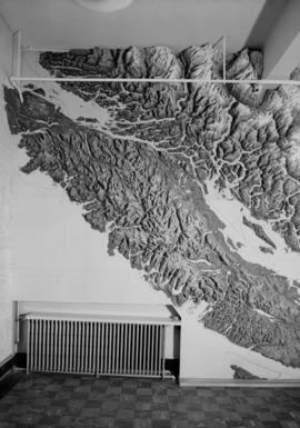
Photograph shows an ethnological map of British Columbia
![Hudson Bay Company Army [recruitmant campaign] window display](/uploads/r/null/2/e/2e4a1deaea587cf23de896ea458f508ecb3c965c3efee4f81c576f323b4677f7/dc9e1c4b-6631-4219-b3bf-a894292c174f-A03719_142.jpg)
Hudson Bay Company Army [recruitmant campaign] window display
![General Worthington's visit to the Province Building [and the] C.P.R.](/uploads/r/null/1/c/1c8ff01aa559723da33198464d5cc5791a1a18b221c1123c1d0d2b4bf34f9e5c/aedd2864-dca2-42e9-b6e9-9b7141f79879-A06248_142.jpg)
General Worthington's visit to the Province Building [and the] C.P.R.

Dept. of Trade and Industry display at P.N.E.

Dept. of Trade and Industry display at P.N.E.
![Civil defence first aid and wardens final [competitions]](/uploads/r/null/9/9/99c29b08980120828c0449431fb622e24888ede2f1d51c74926fe316af149bc7/e5c123f4-26cf-4ad4-bded-7593441be021-A06127_142.jpg)
Civil defence first aid and wardens final [competitions]
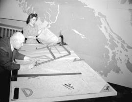
Photograph shows a three-dimensional map

A.R.P. W.C. Mainwaring and the Honourable Angus McDonald

Photograph shows three men looking at a three dimensional map


A.R.P. Port Alberni control room

A.R.P. Port Alberni control room

A.R.P. Port Alberni control room

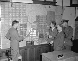
Photograph shows a local areas (communities) map
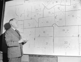
Photograph shows a man in front of a local areas (communities) map

A.R.P. Honourable Angus McDonald, W.C. Mainwaring and Commander Barrie
![A.R.P. first aid competition [at] Seaforth Armouries](/uploads/r/null/c/8/c82d4fae3ae0e078e194fc242d4763a367307d780d4f0c85028ba5fd6f194edb/940a3a91-b1ff-409f-8162-7403c780da1a-A06088_142.jpg)
A.R.P. first aid competition [at] Seaforth Armouries
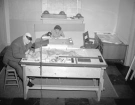
Photograph shows a three-dimensional street map
![A.R.P. first aid competition [at] Seaforth Armouries](/uploads/r/null/2/f/2fc1b74dd7e046f94d140b9dd0bdd0df49ffbe45d9684e64b6621ed3604dd6d6/9daf712b-285e-44e4-b94c-e50eece42385-A06075_142.jpg)
A.R.P. first aid competition [at] Seaforth Armouries
Photograph shows a man judging a three-dimensional street map
![A.R.P. first aid competition [at] Seaforth Armouries](/uploads/r/null/2/5/25929543d53336cd6b1cf824c48ad917349fb97f5482c26d1d63aa3cfe5b1667/1fbbcd48-c93f-4736-b82a-7bad8782339f-A06074_142.jpg)
A.R.P. first aid competition [at] Seaforth Armouries
Photograph shows a man judging a three-dimensional street map
![A.R.P. first aid competition [at] Seaforth Armouries](/uploads/r/null/6/e/6e91a813d6246d4ca0c595c4378757f0dd9d6d400ad607b0659456e0055f058b/687d06fb-f08d-4b06-92e5-96796af8da2d-A06085_142.jpg)
A.R.P. first aid competition [at] Seaforth Armouries
Photograph shows a three-dimensional street map

Photograph shows a three-dimensional street map

Group portrait showing a three-dimensional street map
