
- COV-S371-: MAP 367-: LEG1336.10
- Part
- Oct. 30, 1913
Part of City of Vancouver fonds
78 results with digital objects Show results with digital objects
Part of City of Vancouver fonds

Part of City of Vancouver fonds

Part of City of Vancouver fonds

Part of City of Vancouver fonds

Part of City of Vancouver fonds

Part of City of Vancouver fonds

Part of City of Vancouver fonds

Part of City of Vancouver fonds

Part of City of Vancouver fonds

Part of City of Vancouver fonds

Part of City of Vancouver fonds

Part of City of Vancouver fonds

Part of City of Vancouver fonds
Part of City of Vancouver fonds

Part of City of Vancouver fonds

Part of City of Vancouver fonds

Part of City of Vancouver fonds

Part of City of Vancouver fonds

Part of City of Vancouver fonds

Part of City of Vancouver fonds

Part of City of Vancouver fonds

Part of City of Vancouver fonds

Part of City of Vancouver fonds

Part of City of Vancouver fonds

Part of City of Vancouver fonds
Part of City of Vancouver fonds

Part of City of Vancouver fonds
Part of City of Vancouver fonds

Part of City of Vancouver fonds

Part of City of Vancouver fonds

Part of City of Vancouver fonds

Part of City of Vancouver fonds

Part of City of Vancouver fonds

Part of City of Vancouver fonds

Part of City of Vancouver fonds

Part of City of Vancouver fonds

Part of City of Vancouver fonds

Part of City of Vancouver fonds

Part of City of Vancouver fonds

Part of City of Vancouver fonds

Part of City of Vancouver fonds
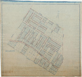
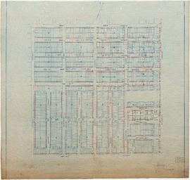
Water service map of South Vancouver
Part of City of Vancouver fonds
Item is a sectional map showing water services, streets, district lots, house numbers, and size of lots in South Vancouver. Map was used by the Water Works Department and the Engineering Department until about 1945, and has been annotated to show changes in street names and address block numbers.
![[View of the] Main St. bog [between 33rd Avenue and 41st Avenue]](/uploads/r/null/7/f/7fb80b09ebfd64e91e42bdfb033c7901f4187e4e47fb8a675f55ecce664255be/0d0df890-2794-44d1-b878-b21f154e60b1-A19256_142.jpg)
[View of the] Main St. bog [between 33rd Avenue and 41st Avenue]
Part of Major Matthews collection
![[View of the 3500 block Commercial Street looking north from 20th Avenue]](/uploads/r/null/f/1/f1b0bce3d006392eacb862cfcf2dcf83c3f8413c7c9f87b3a1112ba5d9f95899/45c4154f-fb02-4471-bfe7-f45508705373-A07869_142.jpg)
[View of the 3500 block Commercial Street looking north from 20th Avenue]
Part of Major Matthews collection
Photograph shows the Bank of Hamilton, Jackson Hardware Co. and the Bank of Vancouver.
![[View of streetcar, automobile, and businesses at] 25th and Fraser Avenue. S[outh] Vancouver, B.C.](/uploads/r/null/9/0/901e8753c8b56d423c574b4d67cb84c95748fc6eca91b25bb09f09dfd40eecc6/92a75128-a994-4238-8f0a-cbc46c8ab828-A04451_142.jpg)
[View of streetcar, automobile, and businesses at] 25th and Fraser Avenue. S[outh] Vancouver, B.C.
Part of Major Matthews collection
![[View of streetcar and businesses at] 49th and Fraser Aves. S[outh] Vancouver](/uploads/r/null/5/7/576330d6b9b9241916a75cabbb1b0f4006e91e6fa5e73dc92d69ed96e9d4b816/e8274e7d-e6c9-447a-80f1-7dda03a6d63f-A04452_142.jpg)
[View of streetcar and businesses at] 49th and Fraser Aves. S[outh] Vancouver
Part of Major Matthews collection
J.S. Matthews' notes with print or negative in Archives.
![[View of road paving at the] Intersection Main St. and 34th Ave. [now 33rd Avenue]](/uploads/r/null/e/b/eb7cbb6633178207f5f6cba577f32455439dead88a072ac334180ac063701e1a/ee3c2d88-476a-4a4c-b0c8-13120cd63792-A19287_142.jpg)
[View of road paving at the] Intersection Main St. and 34th Ave. [now 33rd Avenue]
Part of Major Matthews collection
![[View of Main Street, looking north from 26th Avenue]](/uploads/r/null/4/c/4cbdef125de15aa81c70e8709b292d5e4f274528f32b6cb2a2105258b3cafcb5/e6b7109b-66b4-4835-afc6-7609526820c9-A07868_142.jpg)
[View of Main Street, looking north from 26th Avenue]
Part of Major Matthews collection
J.S. Matthews' notes with print or negative in Archives.
![[View of Main Street looking north from the river bank]](/uploads/r/null/d/b/db98e883bbdc151f270cd3471629ad5f509b7c38028d1ca3c2913bfc7a2e6004/6ab1fd0d-8c7a-4104-a4f8-d74669739de2-A37158_142.jpg)
[View of Main Street looking north from the river bank]
Part of Major Matthews collection
![[View of Main Street looking north from about 64th Avenue]](/uploads/r/null/a/7/a731d8302c523c6979f46e7674ec30b321dcb3566a777e687c30268e03a6d0ca/2bcbccc2-7bc7-48f4-a4a8-bbafd71760c3-A37088_142.jpg)
[View of Main Street looking north from about 64th Avenue]
Part of Major Matthews collection