![](/images/icons-large/icon-archival.png)
Showing 84 results
Archival description83 results with digital objects Show results with digital objects
![Sectional map of Vancouver showing streets, block and lot outlines, and building perimeters: Map ...](/uploads/r/null/c/4/a/c4a2e45ed5e33ca8307ce70de5a2dfd6a1be456df93bbb30e545ad799e4ab5af/bb4a0073-fc1b-4005-9d9c-ecfacb77181a-LEG1376_142.jpg)
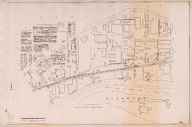
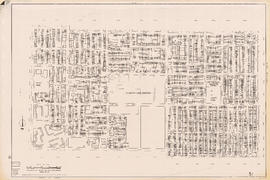
Sectional map of Vancouver showing streets, block and lot outlines, and building perimeters: Map 5 : Lagoon Street to Nicola Street and Robson Street to English Bay
![Sectional map of Vancouver showing streets, block and lot outlines, and building perimeters : Map...](/uploads/r/null/f/5/8/f58ae97591f3bd02d49a943edfbf155598e320d727000651c8edb06b620eb6ec/d9ab36fd-485d-481f-b478-982bb474140a-LEG1376_142.jpg)
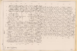
Sectional map of Vancouver showing streets, block and lot outlines, and building perimeters : Map 90 : Iona Island to Wood Island and Celtic Avenue to Sea Island
![Sectional map of Vancouver showing streets, block and lot outlines, and building perimeters : Map...](/uploads/r/null/2/d/c/2dcf7656e9d23458af92f0c0b9111b95f60b9b905170d8744c2c4b739e66f00b/85ba9133-8524-4536-8a3b-4ef39df88af8-LEG1376_142.jpg)
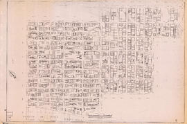
Sectional map of Vancouver showing streets, block and lot outlines, and building perimeters : Map 9 : Main Street to Clark Drive and Burrard Inlet to Prior Street
![Sectional map of Vancouver showing streets, block and lot outlines, and building perimeters : Map...](/uploads/r/null/a/c/5/ac5bead000304c7c485e9ff59565a3df8065d431a172a4c2f079adcd737cbacd/3918b2d0-c98c-4763-a37b-6a8643773c35-LEG1376_142.jpg)
Sectional map of Vancouver showing streets, block and lot outlines, and building perimeters : Map 89 : Area west of Angus Drive to Barnard Street and S.W. Marine Drive to the North Arm of the Fraser River
![Sectional map of Vancouver showing streets, block and lot outlines, and building perimeters : Map...](/uploads/r/null/7/8/7/787d6a324e6b37730f317e96af71cb4f427e0cb299754a3dbb474d9da1874502/c33260e9-5702-4a3c-bb28-7fe056dcc522-LEG1376_142.jpg)
Sectional map of Vancouver showing streets, block and lot outlines, and building perimeters : Map 88 : MacDonald Street to Laburnum Street/Angus Drive and 57th Avenue to the North Arm of the Fraser River
![Sectional map of Vancouver showing streets, block and lot outlines, and building perimeters : Map...](/uploads/r/null/a/4/b/a4b97c6d07cf70cd6fd6b1cdf2dd3d38bf32e3b5fe1747a557533438bc7bc0b6/3308c9f5-8a87-43b2-a716-c70f8e499b4d-LEG1376_142.jpg)
Sectional map of Vancouver showing streets, block and lot outlines, and building perimeters : Map 87 : Barnard Street to Heather Street and 75th Avenue/Kent Avenue South to the North Arm of the Fraser River
![Sectional map of Vancouver showing streets, block and lot outlines, and building perimeters : Map...](/uploads/r/null/9/c/3/9c3ba47778d9b465e565d59d0da8fc4d55738b9a6840c0318d0f0b57f047ba42/dc3f3b85-86c2-4aeb-8c3f-f01415abeefc-LEG1376_142.jpg)
Sectional map of Vancouver showing streets, block and lot outlines, and building perimeters : Map 86 : Angus Drive to Laurel Street and 68th Avenue/67th Avenue to the North Arm of the Fraser River
![Sectional map of Vancouver showing streets, block and lot outlines, and building perimeters : Map...](/uploads/r/null/6/4/0/640c418be50e5b1d5d6bcbbdfbf8b97a8dad04817ae6c0d99b7d5a7a4a5b94b4/f2f3e239-d872-44c3-8f59-b60ca5de8c7f-LEG1376_142.jpg)
Sectional map of Vancouver showing streets, block and lot outlines, and building perimeters : Map 85 : Laburnum Street to Fremlin Street and 57th Avenue to 68th Avenue/67th Avenue
![Sectional map of Vancouver showing streets, block and lot outlines, and building perimeters : Map...](/uploads/r/null/9/6/a/96ae0ac4b87faf63b3bdfcf4c630418331dc291c4b24306cbdfaef7175636edc/316c9f7e-f3a5-4f8f-b5b1-1bd0b3452e95-LEG1376_142.jpg)
Sectional map of Vancouver showing streets, block and lot outlines, and building perimeters : Map 84 : Laurel Street to Main Street and 67th Avenue/S.W. Marine Drive to the North Fork of the North Arm of the Fraser River
![Sectional map of Vancouver showing streets, block and lot outlines, and building perimeters : Map...](/uploads/r/null/0/b/0/0b0474e31252536e51f583f27862ec8638fc676b20088bba806a0b434d2d9e2f/42d3757e-6ba2-4157-8004-65e6b08b7065-LEG1376_142.jpg)
Sectional map of Vancouver showing streets, block and lot outlines, and building perimeters : Map 83 : Fremlin Street to Main Street and 57th Avenue to 67th Avenue/S.W. Marine Drive
![Sectional map of Vancouver showing streets, block and lot outlines, and building perimeters : Map...](/uploads/r/null/1/5/4/1542d2dd256070a784cf619271d75f7a77ba0b083e08e6b1b580cce1937f9216/dc245bbf-050a-447c-9c10-0449ff52ccaf-LEG1376_142.jpg)
Sectional map of Vancouver showing streets, block and lot outlines, and building perimeters : Map 82 : Main Street to Crompton Street and S.E. Marine Drive to the North Fork of the North Arm of the Fraser River
![Sectional map of Vancouver showing streets, block and lot outlines, and building perimeters : Map...](/uploads/r/null/9/c/b/9cb93c71fb197ada450d45b80adea88e38b150c536cad8ee70ce5c750fa0e58c/2a338b7a-d7b1-41f5-95ba-a5d009eb3cdd-LEG1376_142.jpg)
Sectional map of Vancouver showing streets, block and lot outlines, and building perimeters : Map 81 : Main Street to Inverness Street and 57th Avenue to S.E. Marine Drive
![Sectional map of Vancouver showing streets, block and lot outlines, and building perimeters : Map...](/uploads/r/null/3/c/1/3c10159a5164ef8aeb192d7961bda30751dee2981f708d4b8f13740343baf9cb/d63332ea-fd53-4e8c-8e5a-9dfc9f3596a7-LEG1376_142.jpg)
Sectional map of Vancouver showing streets, block and lot outlines, and building perimeters : Map 80 : Inverness Street to Gladstone Street/Nanaimo Street and 61st Avenue to the North Fork of the North Arm of the Fraser River
![Sectional map of Vancouver showing streets, block and lot outlines, and building perimeters : Map...](/uploads/r/null/0/4/f/04f9889616bdfdc635c0951241eb20a64d9a12c6fa651fefa6e814f426813db0/2c2ec541-4796-4811-8590-3e5511269766-LEG1376_142.jpg)
Sectional map of Vancouver showing streets, block and lot outlines, and building perimeters : Map 8 : Piers at Burrard Inlet between Main Street and Clark Drive
![Sectional map of Vancouver showing streets, block and lot outlines, and building perimeters : Map...](/uploads/r/null/d/3/2/d329e9043ff0e37c323d3d66d6d0c23fbae7799222cbb9b4ab10ae9975a51e72/394e276d-283d-4abd-aead-9b513f0dd3d6-LEG1376_142.jpg)
Sectional map of Vancouver showing streets, block and lot outlines, and building perimeters : Map 79 : Gladstone Street/Nanaimo Street to Kerr Street and Bobolink Avenue to the North Arm of the Fraser River
![Sectional map of Vancouver showing streets, block and lot outlines, and building perimeters : Map...](/uploads/r/null/9/3/3/933c3bb8b8f43990113588c8aa0fb191f5834dee4483013f34941fe252fc182e/89aab190-96f5-47bb-8b68-405e2cc469b8-LEG1376_142.jpg)
Sectional map of Vancouver showing streets, block and lot outlines, and building perimeters : Map 78 : Kerr Street to Boundary Road and S.E. Marine Drive to the North Arm of the Fraser River
![Sectional map of Vancouver showing streets, block and lot outlines, and building perimeters : Map...](/uploads/r/null/e/f/4/ef489909404ddb5c9430d44c509016c73afc5e157d81ab5decb01cffdf659691/5cb696d9-a8b2-4812-953f-4983824d0450-LEG1376_142.jpg)
Sectional map of Vancouver showing streets, block and lot outlines, and building perimeters : Map 76 : Kerr Street to Boundary Road and 49th Avenue/48th Avenue to Rosemont Drive
![Sectional map of Vancouver showing streets, block and lot outlines, and building perimeters : Map...](/uploads/r/null/c/8/0/c8064866d4371d220a781ccd6c74cb25683257f8318592a170ccb797ed6aefe3/241435c1-58cf-43b1-9563-b41361f561d9-LEG1376_142.jpg)
Sectional map of Vancouver showing streets, block and lot outlines, and building perimeters : Map 75 : Nanaimo Street to Kerr Street and 49th Avenue to Bobolink Avenue
![Sectional map of Vancouver showing streets, block and lot outlines, and building perimeters : Map...](/uploads/r/null/d/3/4/d345fc2af1afaedae31ad5cb68c2a52458f883c90e1f2a6f651c86781c1c2ff0/36940e0b-5ae4-4cc8-abec-bc7d7ff96a38-LEG1376_142.jpg)
Sectional map of Vancouver showing streets, block and lot outlines, and building perimeters : Map 74 : Inverness Street to Nanaimo Street and 49th Avenue to 61st Avenue
![Sectional map of Vancouver showing streets, block and lot outlines, and building perimeters : Map...](/uploads/r/null/2/9/4/294fe7f242cd7500d4c4bafe987c5692ef222dcab696e25471e91cc4872dece0/465f233d-3750-48ff-b48b-eed765090347-LEG1376_142.jpg)
Sectional map of Vancouver showing streets, block and lot outlines, and building perimeters : Map 73 : Quebec Street to Inverness Street and 47th Avenue to 57th Avenue
![Sectional map of Vancouver showing streets, block and lot outlines, and building perimeters : Map...](/uploads/r/null/b/3/6/b362c0a429519aa8b3f7d6fb52c6021c379a460af2f9db8f90327ce44a700e8a/24bb31e8-ebd1-4ef4-acd2-08923a27dc67-LEG1376_142.jpg)
Sectional map of Vancouver showing streets, block and lot outlines, and building perimeters : Map 72 : Oak Street to Quebec Street and 46th Avenue to 57th Avenue
![Sectional map of Vancouver showing streets, block and lot outlines, and building perimeters : Map...](/uploads/r/null/6/5/3/65383bd46e1870a5398065f25912104b37f9cade1c947cfd2bb80666adffc303/cd519c38-80f7-46de-a15d-80e8b50d0add-LEG1376_142.jpg)
Sectional map of Vancouver showing streets, block and lot outlines, and building perimeters : Map 71 : Cypress Street to Oak Street and 49th Avenue to 57th Avenue
![Sectional map of Vancouver showing streets, block and lot outlines, and building perimeters : Map...](/uploads/r/null/0/d/b/0dbb84951cfc13193e7c77a1a10440c22005b04dc9ff8e5f1102ee8a673f98fd/3dda75c9-b948-4fce-9daa-5826b3e4df6a-LEG1376_142.jpg)
Sectional map of Vancouver showing streets, block and lot outlines, and building perimeters : Map 70 : Macdonald Street to Cypress Street and 49th Avenue to 57th Avenue
![Sectional map of Vancouver showing streets, block and lot outlines, and building perimeters : Map...](/uploads/r/null/8/1/d/81d69190b8d735432d759dfd834354d4177fdf2a9830c3f49d17810dd1a57497/1c6ca772-67fd-448c-8259-eed4289d62d5-LEG1376_142.jpg)
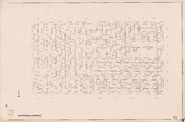
Sectional map of Vancouver showing streets, block and lot outlines, and building perimeters : Map 7 : Burrard Street to Main Street and Burrard Inlet to Georgia Street
![Sectional map of Vancouver showing streets, block and lot outlines, and building perimeters : Map...](/uploads/r/null/2/a/0/2a0f39927125f404af43951d20cd59897a600983aa165cac7ebd27ba2e7b21d4/0a2b19cb-ba6e-44c4-ba81-4f774852358b-LEG1376_142.jpg)
Sectional map of Vancouver showing streets, block and lot outlines, and building perimeters : Map 69 : Wallace Street to MacDonald Street and 49th Avenue to the North Arm of the Fraser River
![Sectional map of Vancouver showing streets, block and lot outlines, and building perimeters : Map...](/uploads/r/null/e/a/5/ea540b965ed02e335a86da3340aea1e3a42ba4e1009926e1747cfb32a79176e3/8b577e60-2dcc-4b78-a9e8-abdb742cc06f-LEG1376_142.jpg)
Sectional map of Vancouver showing streets, block and lot outlines, and building perimeters : Map 67 : Musqueam Indian Reserve and Shaughnessy Golf Course
![Sectional map of Vancouver showing streets, block and lot outlines, and building perimeters : Map...](/uploads/r/null/c/0/f/c0f84df75f51581eb146a63e81497481ba85af5bec4222d6085121a6e23568ce/156614fc-1985-4216-8add-751e054e636c-LEG1376_142.jpg)
Sectional map of Vancouver showing streets, block and lot outlines, and building perimeters : Map 66 : Crown Street to Balaclava Street and 41st Avenue to 49th Avenue
![Sectional map of Vancouver showing streets, block and lot outlines, and building perimeters : Map...](/uploads/r/null/7/4/c/74c884d41d18a77792e6b81e08fea6f626891abef3484dd80fda7b65b62bd0b0/440155f9-0ae1-48d6-9616-b47c8faf474f-LEG1376_142.jpg)
Sectional map of Vancouver showing streets, block and lot outlines, and building perimeters : Map 65 : Camosun Street to Carnarvon Street and 33rd Avenue to 41st Avenue
![Sectional map of Vancouver showing streets, block and lot outlines, and building perimeters : Map...](/uploads/r/null/c/8/9/c89f536cb90ca163ab0d43c175a959089ef275c618b72e89bcab0536839b123a/7ef64803-4945-4eed-9b76-387f43da0abf-LEG1376_142.jpg)
Sectional map of Vancouver showing streets, block and lot outlines, and building perimeters : Map 64 : Balaclava Street to Cypress Street and 41st Avenue to 49th Avenue
![Sectional map of Vancouver showing streets, block and lot outlines, and building perimeters : Map...](/uploads/r/null/b/3/4/b343ab94249396b5c4992c3cf77a3ed2558117e0da13ec600f50ebf180e48fc9/c88a934e-b043-4306-ad11-1b41eac02237-LEG1376_142.jpg)
Sectional map of Vancouver showing streets, block and lot outlines, and building perimeters : Map 63 : Carnarvon Street to Cypress Street and 33rd Avenue to 41st Avenue
![Sectional map of Vancouver showing streets, block and lot outlines, and building perimeters : Map...](/uploads/r/null/4/f/f/4ff61d78c18962f1f3963d01be25a867df7b5feb334276502d0deaff9baafee1/17b82cb6-bb49-44ce-b336-fb5546fa460f-LEG1376_142.jpg)
Sectional map of Vancouver showing streets, block and lot outlines, and building perimeters : Map 62 : Cypress Street to Oak Street and 41st Avenue to 49th Avenue
![Sectional map of Vancouver showing streets, block and lot outlines, and building perimeters : Map...](/uploads/r/null/4/8/9/4893dd1092cfd540330a7f0396f6eaad6b071d8e14ccb9738f1d05f4fb65dca4/6c00cfca-3fa8-41ce-9923-4c6464b4c91b-LEG1376_142.jpg)
Sectional map of Vancouver showing streets, block and lot outlines, and building perimeters : Map 61 : Cypress Street to Oak Street and 33rd Avenue to 41st Avenue
![Sectional map of Vancouver showing streets, block and lot outlines, and building perimeters : Map...](/uploads/r/null/9/f/1/9f169a32a546a2d841939a69076df5bd7ea91585b45ef650353cd83318f689a3/45b14e4e-de63-4502-81a2-b32e19ad340d-LEG1376_142.jpg)
Sectional map of Vancouver showing streets, block and lot outlines, and building perimeters : Map 60 : Oak Street to Quebec Street and 37th Avenue to 46th Avenue
![Sectional map of Vancouver showing streets, block and lot outlines, and building perimeters : Map...](/uploads/r/null/d/9/b/d9b5e26ac22c0f36f7f8339f64c1e5a38f61e1550cbd3b73fae0d48fa44eb54d/2b0363c5-363d-4f43-814a-7ef2cdbf559b-LEG1376_142.jpg)
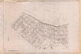
Sectional map of Vancouver showing streets, block and lot outlines, and building perimeters : Map 6 : Nicola Street to Beatty Street and Georgia Street to Beach Avenue/Drake Street
![Sectional map of Vancouver showing streets, block and lot outlines, and building perimeters : Map...](/uploads/r/null/4/5/e/45e0ba0cc2908c05620a9de99df25399f7ef195d354073966d2dca93dbffe697/191da5a5-2eda-4af5-a85b-0318a61ab372-LEG1376_142.jpg)
Sectional map of Vancouver showing streets, block and lot outlines, and building perimeters : Map 59 : Quebec Street to Inverness Street and 37th Avenue to 47th Avenue
![Sectional map of Vancouver showing streets, block and lot outlines, and building perimeters : Map...](/uploads/r/null/6/2/0/6206dd365ddeaa24424949b880704c1442d25bb6e79f4cda7dcce689952c098c/0fd99c3e-ebcc-4941-96bb-103b758a3a6a-LEG1376_142.jpg)
Sectional map of Vancouver showing streets, block and lot outlines, and building perimeters : Map 58 : Inverness Street to Berkley Street/Nanaimo Street and 41st Avenue to 49th Avenue
![Sectional map of Vancouver showing streets, block and lot outlines, and building perimeters : Map...](/uploads/r/null/2/7/3/27357b0204308088ac8a5b9571baa16a3842f4251ef0e3bf1abb69e02e9f0ca7/e36c4c40-631a-4c3e-a904-5d46d5aa8085-LEG1376_142.jpg)
Sectional map of Vancouver showing streets, block and lot outlines, and building perimeters : Map 57 : Berkley Street/Nanaimo Street to Joyce Street/Doman Street and 41st Avenue to 49th Avenue
![Sectional map of Vancouver showing streets, block and lot outlines, and building perimeters : Map...](/uploads/r/null/4/d/2/4d25e94f9fe1a907c9c633c103ecba980a85b188f687989d546bcc95216bfe11/f730a54d-e56e-432b-a95f-19a34f14f8f1-LEG1376_142.jpg)
Sectional map of Vancouver showing streets, block and lot outlines, and building perimeters : Map 56 : Joyce Street/Doman Street to Boundary Road and Kingsway to 49th Avenue
![Sectional map of Vancouver showing streets, block and lot outlines, and building perimeters : Map...](/uploads/r/null/4/1/e/41efe8b586d358a173461b77ca5164c83e320228ca5a7df370542b299b69e6cb/cf91a1c5-414f-4572-b2ba-29bc26701a2e-LEG1376_142.jpg)
Sectional map of Vancouver showing streets, block and lot outlines, and building perimeters : Map 55 : McHardy Street/Cecil Street to Boundary Road and Wellington Avenue/Monmouth Avenue to Kingsway
![Sectional map of Vancouver showing streets, block and lot outlines, and building perimeters : Map...](/uploads/r/null/5/d/b/5db39441b59b0ead9d41678e51f11017d25b8a70cc4087034cf5463ab961b4c3/d0f8f7e7-627e-4aae-af31-a50fcd8e68c9-LEG1376_142.jpg)
Sectional map of Vancouver showing streets, block and lot outlines, and building perimeters : Map 54 : Nanaimo Street to McHardy Street/Cecil Street/Joyce Street and Ward Street/Euclid Avenue/Vanness Avenue to 41st Avenue
![Sectional map of Vancouver showing streets, block and lot outlines, and building perimeters : Map...](/uploads/r/null/f/c/e/fce8d8b8b20a42c69cd83a9fd61e9e1ab87a28dc6116a42fe9a2c84480ecb747/ed383b62-7b74-45c0-8a99-a648d99af3d9-LEG1376_142.jpg)
Sectional map of Vancouver showing streets, block and lot outlines, and building perimeters : Map 53 : Inverness Street to Nanaimo Street and 32nd Avenue to 41st Avenue
![Sectional map of Vancouver showing streets, block and lot outlines, and building perimeters : Map...](/uploads/r/null/d/9/6/d96c8d3d686b17354158d518c48e1e55098d51615617664375f285d361567147/6b710cdc-b538-4c8b-b3f0-2f7cbf642585-LEG1376_142.jpg)
Sectional map of Vancouver showing streets, block and lot outlines, and building perimeters : Map 52 : Inverness Street to Nanaimo Street and 22nd Avenue/24th Avenue to 32nd Avenue
![Sectional map of Vancouver showing streets, block and lot outlines, and building perimeters : Map...](/uploads/r/null/3/3/e/33e8c5ed4d285d1a3a3b4630aae8c6df7c22203fa2cf81c5564d19b856f5945e/823b4bac-b620-4892-8b81-56be88e27963-LEG1376_142.jpg)
Sectional map of Vancouver showing streets, block and lot outlines, and building perimeters : Map 51 : Ontario Street to Inverness Street and 28th Avenue to 37th Avenue
![Sectional map of Vancouver showing streets, block and lot outlines, and building perimeters : Map...](/uploads/r/null/3/4/6/346495676b94e580427723a9ae4eedf8da519443120d3542995b0c634fd3214a/1670a517-b7f2-4bc6-b3f2-5b80d4079a3e-LEG1376_142.jpg)
Sectional map of Vancouver showing streets, block and lot outlines, and building perimeters : Map 50 : Oak Street to Ontario Street and 28th Avenue to 37th Avenue
![Sectional map of Vancouver showing streets, block and lot outlines, and building perimeters : Map...](/uploads/r/null/d/1/8/d1899726947a19206b3cbbf326f28378af9515b27d0b9fad60d72423b0069592/38136101-dff4-4bd7-bcda-ba0e56d2984d-LEG1376_142.jpg)
Sectional map of Vancouver showing streets, block and lot outlines, and building perimeters : Map 49 : Arbutus Street to Oak Street and Laurier Avenue to 33rd Avenue
![Sectional map of Vancouver showing streets, block and lot outlines, and building perimeters : Map...](/uploads/r/null/3/0/6/306482e06202727a2dbdf1c549a8181aa01e5440c05bc06764395aafebe0933a/5c0a6135-9d35-4fcd-8cd2-48805c400584-LEG1376_142.jpg)
Sectional map of Vancouver showing streets, block and lot outlines, and building perimeters : Map 48 : Blenheim Street to Arbutus Street King Edward Avenue/23rd Avenue ro 33rd Avenue
![Sectional map of Vancouver showing streets, block and lot outlines, and building perimeters : Map...](/uploads/r/null/6/7/0/670cda38db46ec51d72e2da749f12e0eecc69c8a78294e08fe97ffcc676774cc/c5f4c145-7d9a-43bc-b90f-8540d71eaa23-LEG1376_142.jpg)
Sectional map of Vancouver showing streets, block and lot outlines, and building perimeters : Map 47 : 29th Avenue at King Edward Avenue to Blenheim Street and King Edward Avenue to 33rd Avenue
![Sectional map of Vancouver showing streets, block and lot outlines, and building perimeters : Map...](/uploads/r/null/1/1/b/11b024e2cada01a18cc2d9218fc69b4692ca86ae9eda67fc6b210c62671ce78b/7dcb2e6a-8ec0-410c-ab61-c0fab8f5086f-LEG1376_142.jpg)
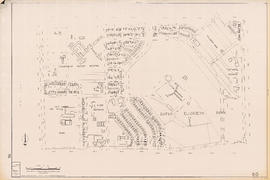
Sectional map of Vancouver showing streets, block and lot outlines, and building perimeters : Map 46 : Blanca Street to Discovery Street and 14th Avenue to 16th Avenue
Results 1 to 50 of 84